


Carlisle & Hadrian’s Wall (Western Frontier)
As the journey turns inland, the character of the landscape shifts once more — from open shoreline to one shaped by borders, defence and history. This final section moves away from the sea and into the western reaches of Hadrian’s Wall, where the coastline gives way to one of Britain’s most significant Roman frontiers.
Carlisle forms the gateway to this chapter, a historic border city whose streets reflect centuries of conflict, trade and strategic importance. Beyond the city, the line of Hadrian’s Wall stretches across the landscape, quieter here than in its central sections, but no less powerful. Forts, earthworks and open countryside reveal the scale of the Roman Empire’s northern boundary.
This is a fitting conclusion to the journey — where the story of Cumbria shifts from maritime routes and coastal settlements to the legacy of empire, bringing the road trip to a close at the meeting point of land, history and horizon.
How to Spend Your Time — Carlisle & Hadrian’s Wall
This final section moves inland from the coast to the Roman frontier, centred on Carlisle and the western and central stretches of Hadrian’s Wall.
It’s a shift in pace and atmosphere — from open coastline to historic landscapes shaped by forts, walls and centuries of border history.
A fitting end to the journey — where the landscape moves from sea to empire.
1 Day — Roman Highlights
Morning: Carlisle Castle → Tullie House Museum
Afternoon: Birdoswald Roman Fort → short Wall walk
Optional: Lanercost Priory
Best for: First visit • Key sites
2 Days — Add the Central Wall
Day 1: Carlisle → Birdoswald → Lanercost
Day 2: Roman Army Museum → Walltown Crags → Vindolanda
Best for: Variety • Landscape + history
3 Days — Full Frontier Experience
Day 1–2: As above with more time
Day 3: Housesteads → Sycamore Gap → longer walk
Best for: Walking • Immersive travel
Half-Day Scenic Drive — Western Hadrian’s Wall
A relaxed inland loop combining Roman ruins, quiet countryside and one of the best-preserved sections of Hadrian’s Wall.
Drive time: ~2 hours • Allow: 3–4 hours with stops
Carlisle → Lanercost Priory → Banks Turret → Birdoswald → return via Irthing Valley
Highlights:
Lanercost Priory • quiet Wall sections • panoramic valley views • longest surviving Wall stretch
Arriving from Silloth to Carlisle
Leaving Silloth, the route turns inland along the A595, moving away from the open shoreline of the Solway Coast. The wide views and sea air give way to flatter farmland and quieter countryside, with the sense of space still present but now shaped by fields, hedgerows and distant fells.
As you approach Carlisle, the landscape begins to tighten again, and the focus shifts from coast to history. The journey moves from open shoreline to one of the most important historic cities in northern England — and the gateway to Hadrian’s Wall.
Carlisle — Frontier city and Roman gateway


Carlisle is a city shaped by its position on the northern edge of England, where centuries of conflict, trade and movement have left a strong and layered identity. From Roman occupation to medieval border clashes, it has long stood as a strategic gateway between England and Scotland.
Today, that history is still visible, particularly in the compact historic quarter where castle, cathedral and museums sit within easy walking distance. As the final stage of this Cumbria coast road trip, Carlisle offers a clear shift in focus — from coastal landscapes to one of Britain’s most important historic frontiers.
• One of England’s most important historic border cities
• Direct access to Hadrian’s Wall and Roman heritage
• Compact historic centre with major attractions close together
What to See & Do
Carlisle Castle – A 900-year-old fortress with exhibitions, wall walks and historic rooms, including prisoner carvings and military displays.
Carlisle Cathedral – A striking medieval cathedral with detailed stonework and stained glass.
Tullie House Museum – A key museum for exploring Roman Britain and the wider history of the region.
Cumbria’s Museum of Military Life – Insight into the area’s military past, located within the castle complex.
Historic Quarter Walks – The castle, cathedral and museums are all within easy walking distance, making this one of the most accessible historic centres in Cumbria.
Check out the Guildhall Museum (April 2026 update - currently closed until further notice, check prior to visit), housed in a building believed to date from the late 14th century.
Solway Aviation Museum (nearby) – A collection of aircraft and aviation artefacts located at Carlisle Airport.
Settle-Carlisle Railway – One of England’s most scenic railway lines, ideal for combining with a day trip or walk.
Talkin Tarn Country Park (nearby) – A peaceful glacial lake set within woodland, offering walks and a quieter contrast to the city.
-
Getting Around – The historic centre is compact and best explored on foot.
Parking –
• City Centre Car Parks – Convenient for castle, cathedral and museums
• On-street Parking – Limited in central areasBest Time to Visit – Daytime for exploring historic sites; quieter outside peak summer.
Facilities – Full range of shops, cafés, restaurants and visitor services.
Carlisle & Hadrian’s Wall (Western Frontier)
Hadrian’s Wall — The Western Frontier of Roman Britain
The Journey from Carlisle — What to Expect
From Carlisle, follow the route toward Burgh-by-Sands and Bowness-on-Solway, where the wall once stretched to the coast.
The road itself is part of the experience.
You pass through open farmland and small villages, with occasional markers and fragments hinting at what once stood here. Unlike the more built-up sections further east, this stretch is defined by space and subtlety — a landscape where the history sits just beneath the surface.
At Burgh-by-Sands, you reach one of the key points along the western wall, where the Roman fort of Aballava once stood. From here, the route continues toward Bowness-on-Solway, widely recognised as the western end of Hadrian’s Wall.
What to See & Do
Burgh-by-Sands – A quiet village marking an important point along the wall, with visible earthworks and a strong sense of its Roman past.
Bowness-on-Solway – The recognised western end of Hadrian’s Wall, set beside the Solway Firth with wide coastal views.
Hadrian’s Wall Path (Western Section) – A flatter, more accessible stretch of the national trail, ideal for shorter walks.
Solway Firth Views – Open views across the estuary toward Scotland, reinforcing the sense of distance and frontier.
Roman Frontier Landscape – Less about ruins, more about understanding the scale and position of the wall within the landscape.
How to Visit — Getting the Most from This Section
Best Approach – Treat this as a short driving route with stops, rather than a single destination. The experience comes from moving through the landscape and understanding how the wall fits into it.
Suggested Route – Carlisle → Burgh-by-Sands → Bowness-on-Solway. This keeps the journey linear and mirrors the original line of the wall.
How Long to Allow –
• 1.5–2 hours – Drive and short stops
• Half day – Add walking sections and time at Bowness
• Full day – Combine with central Hadrian’s Wall sites further east
Walking Options – The western section is ideal for short, accessible walks rather than long hikes. Even a 20–30 minute walk along the Hadrian’s Wall Path gives a strong sense of place.
What Makes This Section Different – Unlike the central sections (with dramatic ruins and visitor centres), the western frontier is quieter and more atmospheric. You won’t see long stretches of standing wall — instead, you experience the landscape it once defined.
Beyond the Western Frontier — The Central Hadrian’s Wall Experience
Hadrian’s Wall emerges gradually — through place names, subtle earthworks and the sense that you are moving along a historic line rather than toward a single landmark. The western end feels quieter and less visited than the central sections, but no less significant. It’s here that the wall meets the Solway Firth, and where the idea of frontier becomes most tangible.
• UNESCO World Heritage Site marking the northern edge of the Roman Empire
• Quieter western sections with fewer crowds and wider landscapes
• A journey that unfolds gradually rather than all at once

While the western section offers a quieter and more atmospheric introduction to Hadrian’s Wall, the most recognisable and heavily visited sites lie further east, across the Northumberland landscape.
This is where the wall becomes more visible.
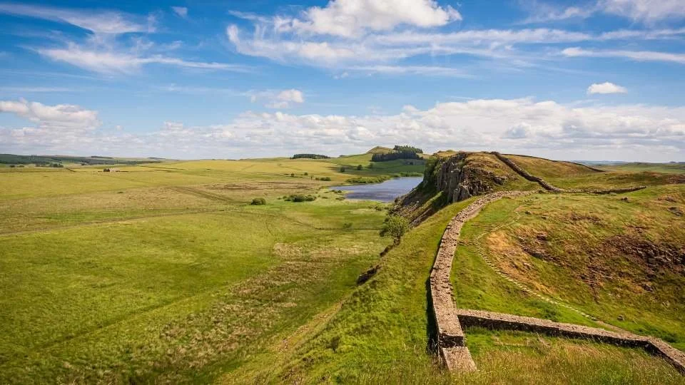
Stone remains rise clearly from the ground, following ridgelines and escarpments, with forts, milecastles and viewpoints spaced along the route. It’s the image most people associate with Hadrian’s Wall — and where some of the most photographed locations in England can be found.
Key sites include:
• Birdoswald Roman Fort – One of the best-preserved sections of the wall, closest to Carlisle
• Housesteads Roman Fort – The most complete and dramatic fort along the wall
• Steel Rigg & Sycamore Gap area – Iconic views along the wall’s ridgeline
A gap along the wall hosted the Sycamore Gap tree (shown). It was one of the most famous trees in the UK, the “Sycamore Gap tree” was named “English Tree of the Year” in 2016, by the conservation charity Woodland Trust. The tree was one of the most photographed trees in the United Kingdom and was also known as “the Robin Hood Tree” because it appeared in the 1991 film Robin Hood: Prince of Thieves. On Wednesday 27th September 2023, the 70ft sycamore was sadly reduced to a stump, by a vandal overnight. (Note the image shown shows the tree in its former glory).
For those wanting to explore further:
• Chesters Roman Fort – Well-preserved baths and riverside setting
• Corbridge Roman Town – A large Roman supply base with extensive remains
Across this central section, the wall itself survives in long, continuous stretches, particularly between Birdoswald and Housesteads. Locations such as Walltown Crags,Cawfields,Winshields and Sewingshields offer some of the most impressive walking and viewpoints along the route.
-
From Carlisle, you can follow the wall east via the B6318 (Military Road) — a scenic route that closely follows the line of the wall.
Allow:
• Half day – Visit Birdoswald and one additional site
• Full day – Explore multiple forts and walk sections of the wall
• Longer – Combine with Northumberland or continue further east
Explore Hadrian’s Wall with English Heritage
This section of the route reaches one of Britain’s most iconic historic landscapes — Hadrian’s Wall, where Roman forts, milecastles and frontier remains stretch across open countryside.
These are some of the best-preserved Roman sites anywhere in Europe — from the dramatic hilltop setting of Housesteads to the riverside remains at Chesters and the expansive ruins at Birdoswald.
Visiting even a couple of these sites individually can quickly add up — especially along this stretch where multiple major locations sit within a short distance.
Annual membership starts from £53 — with 15% off using code AFFEH1526 until 31.12.2026.
Membership often pays for itself in just 2–3 visits, making this one of the best-value sections of the entire route.
Get 15% Off MembershipEnd of Chapter 5 — Carlisle & Hadrian’s Wall (Western Frontier)
End of the Cumbria Coast Road Trip
Cumbrian Coastal Route Last updated: 27 April 2026
Some links may earn Uncover Britain a small commission at no extra cost to you. This helps support the ongoing creation, review and presentation of our road trip guides.
Route information and listings are provided for general guidance only. Always use your preferred navigation system and check official websites to confirm suitability, opening times and the latest details before travelling.
Our guides are reviewed regularly and supported by a mix of editorial research and digital tools to help keep content clear and up to date. If you spot anything that needs updating, we’re always glad to hear from you.