


West Cumbria Coast & St Bees Head
As the route continues north, the landscape begins to shift again — becoming wilder, more rugged and unmistakably coastal. This stretch of West Cumbria feels more remote, where long, open views give way to dramatic cliffs and a stronger connection to the sea.
Starting at Haverigg, the coastline opens out before narrowing toward Ravenglass, a small but historically significant settlement where estuaries meet and Roman history lingers. From here, the route traces the shoreline through Seascale toward St Bees, where the character changes completely. St Bees Head rises above the coast in red sandstone cliffs, marking Cumbria’s only Heritage Coast and one of the most striking sections of the entire journey.
The section culminates in Whitehaven, a historic harbour town with deep maritime roots, where Georgian streets, docks and waterfront views provide a natural pause. This is where the coastline feels most complete — a balance of wild landscape, history and human connection to the sea.
How to Spend Your Time — West Cumbria & St Bees
This section runs from Haverigg to Whitehaven, where estuaries give way to cliffs, seabirds and some of the most dramatic coastal scenery on the route.
If you're following the full journey, this is one of the standout sections. If not, it works as a compact and visually striking coastal trip.
1 Day — Coastal Highlights
Morning: Haverigg → Ravenglass Roman Bath House
Midday: Seascale → St Bees Head cliffs
Afternoon: Whitehaven harbour
Best for: Scenery • Key landmarks
2 Days — Add Depth
Day 1: Coastal route to St Bees
Day 2: Whitehaven + longer coastal walks
Best for: Walking • Coastal exploration
3 Days — Full Exploration
Day 1–2: As above
Day 3: Wasdale detour or extended cliff walks
Best for: Landscape contrast • Slower travel
Short on Time? Take the Scenic Drive Instead
If you’re not doing the full road trip, this is one of the most dramatic drives on the entire route — cliffs, estuaries and open sea views.
Drive time: ~2 hours • Allow: 3–4 hours
Haverigg → Ravenglass → Seascale → St Bees → Whitehaven
Highlights:
Roman Ravenglass • St Bees cliffs • seabirds • Georgian harbour
Arrival — Toward Haverigg and the West Coast
Leaving the Furness Peninsula behind, the route returns briefly inland before following the quieter road north. The landscape begins to open out again as it meets the edge of the Duddon Estuary, before gradually returning to the shoreline.
At Haverigg, the coast reappears more clearly — wider, simpler and more immediate — marking the start of a new stretch of the journey, where the focus shifts back to beaches, open sea and the more dramatic coastline that lies ahead.
Haverigg — Coastal village and open beach
Haverigg is a small coastal village set between the Duddon Estuary and the Irish Sea, where the landscape feels open and uncomplicated. With its marina, wide beach and views toward Black Combe, it offers a quieter introduction to this stretch of the west coast.
Less about major attractions and more about space and setting, Haverigg works as a gentle re-entry to the coastline — a place to pause, walk along the shore and take in the wider surroundings before continuing north.
• Wide, accessible beach with open coastal views
• Quiet village setting between estuary and sea
• Gateway to walking routes and the west coast
What to See & Do
Haverigg Beach – A long, open stretch of sand with views across the Irish Sea, ideal for walking and enjoying the coastal setting.
Haverigg Marina & Lagoon – A calm waterside area offering a contrast to the open sea, with space to pause and take in the surroundings.
Black Combe (nearby) – A prominent fell rising behind the coast, offering far-reaching views across the sea and surrounding landscape.
Haverigg & Whicham Valley Cycle Route – A quieter cycling route linking the coastal plain with inland valleys and open countryside.
Silecroft Beach (nearby) – A wide, less-visited beach backed by Black Combe, offering a more remote coastal feel.
The Eskdale Cycle Trail, 14 km (8.5 miles), goes from the foot of the Scafell range via riverside pastures, meadows, and historic oak woods of the Eskdale Valley down to Ravenglass on the Irish Sea.
-
Getting Around – Easily explored on foot once parked; nearby beaches and viewpoints are a short drive away.
Parking –
• Haverigg Beach Car Park – Main access point for the beach and marina
• Silecroft Beach Car Park (nearby) – For a quieter coastal stopBest Time to Visit – Clear days for views toward Black Combe and across the sea; quieter outside peak summer.
Facilities – Basic facilities including café and toilets near the beach.
Walking & Access – Flat, accessible beach and paths, with more challenging walking routes available on nearby fells.

Continuing the Journey — Toward Ravenglass & the Heritage Coast
From Haverigg, the route follows the shoreline north toward Ravenglass. The coastline begins to change again here, becoming more defined and dramatic, with historic sites and the first hints of the cliffs and heritage coast that lie ahead.
Ravenglass - Roman Roots, Coastal Views & Heritage Railways
Ravenglass sits at a unique meeting point where river, estuary and sea come together, creating a landscape that feels both open and contained. Surrounded by water on three sides and backed by the rising fells, it has a distinct sense of place that sets it apart from other coastal stops along the route.
Despite its small size, Ravenglass carries a deep historical significance, with Roman origins and long-standing connections to trade and transport. Today, it works as both a quiet coastal village and a natural gateway between the shoreline and the Eskdale Valley, where the character of the journey begins to shift once more.
• The Lake District’s only coastal village
• Roman history and medieval heritage
• Access point for Eskdale by heritage railway
• A contrast to the mountain scenery inland
What to See & Do
Muncaster Castle – A medieval castle set in extensive woodland gardens just outside the village. The on-site Hawk & Owl Centre, with regular flying displays, adds broader appeal, making this a rewarding 2–3 hour stop if you want to balance wild scenery with heritage and gardens.
Ravenglass & Eskdale Railway (La’al Ratty) – A narrow-gauge heritage railway running inland to Dalegarth in Eskdale. The journey is scenic and relaxed, passing rivers, woodland and open valley views.
Ravenglass Roman Bath House (Walls Castle) – The remains of a Roman fort bathhouse, surprisingly intact and freely accessible, reflecting the village’s ancient strategic importance.
Ravenglass Beach & Estuary Walks – Pebbled shoreline and tidal flats offering expansive views across the coast toward Black Combe. A good leg-stretch before returning to mountain roads.
-
Ravenglass is a small coastal village at the mouth of the Rivers Esk, Irt and Mite, where they meet the Irish Sea. It marks the western gateway to Eskdale and the Wrynose/Hardknott mountain passes.
The village itself is compact and walkable. Most key sights — the harbour, Ravenglass & Eskdale Railway (La’al Ratty), Roman Bath House and access to Muncaster Castle — are within a short distance of the main road (A595).
By Road
Ravenglass sits directly on the A595 coastal road, making it straightforward to reach from:
• Eskdale via minor valley roads
• Wasdale via Gosforth
• The western Cumbrian coast (Whitehaven / Millom)
• The Wrynose & Hardknott Pass route (more challenging)Roads approaching from Eskdale and the passes are narrow and twisting. Allow extra time and drive cautiously.
Car Parking
Main Village Car Park (CA18 1SD)
• Pay-and-display
• Closest to harbour and railway
• Public toilets nearbyRavenglass & Eskdale Railway Car Park
• Larger parking area
• Ideal if visiting La’al Ratty or starting a walkMuncaster Castle Car Park
• Signposted from A595
• Included with attraction entryParking can fill quickly in summer and during school holidays.
When to Visit
• Quieter than central Lake District villages
• Can feel exposed in strong coastal winds
• Very good shoulder-season stop (spring & autumn)
• Railway operates seasonally — check opening timesWalking & Coastal Access
• Short harbour walk with sea views
• Coastal path sections for longer walks
• Access to Eskdale via the railway or roadThe terrain is flat around the harbour but uneven on shingle.
Combining Ravenglass with the Loop
Ravenglass works best as:
• A break after descending from Wrynose/Hardknott
• A base before heading inland to Wasdale
• A coastal contrast before returning via the mountain passesIt provides a change of scale — from high mountain roads to open sea horizon — before the route turns inland again.
-
What It Is
The Ravenglass & Eskdale Railway is a narrow-gauge heritage steam railway running 7 miles from Ravenglass to Dalegarth near Boot in Eskdale.
Known locally as “La’al Ratty”, it’s one of the oldest and longest narrow-gauge railways in England and offers a completely different way to experience the valley.
Why It’s Worth Doing
• Scenic journey into Eskdale without driving narrow valley roads
• Ideal if you’re not tackling Hardknott or Wrynose
• Excellent in mixed weather
• Strong appeal for families and railway enthusiasts
• Connects directly to walking routes at DalegarthHow to Visit
Start point: Ravenglass Station (signposted from village car park)
Journey time: Approx. 40 minutes each way
Return options:
• Same train back
• Walk part-way and rejoin later service
• One-way if combining with car pickupTrains run seasonally, typically spring through autumn, with reduced winter service. Always check timetable in advance.
Parking & Access
• Dedicated railway car park next to Ravenglass station
• Toilets and café on site
• Level boarding — generally accessibleArrive early during school holidays or sunny weekends.
Coastal & Riverside Walks from Ravenglass
Ravenglass sits at the meeting point of the Rivers Esk, Mite and Irt, making it a natural starting point for a range of walks that combine coastline, estuary and inland valleys. This is where the Cumbria coast begins to connect more closely with the Lake District landscape.
Estuary & Coastal Walks
- Ravenglass Coastal Paths – Short walks along the shoreline and estuary edges, with changing views across water, sand and distant hills.
- Ravenglass to Muncaster Area – A scenic route linking the village to the Muncaster Estate through woodland, riverside and coastal scenery.
Riverside & Inland Routes
- Ravenglass to Eskdale – Gentle riverside walks following the River Esk inland, with quieter surroundings and views toward the fells.
- Eskdale Trail & Cycle Route – A longer inland route through the Eskdale Valley, passing woodland, meadows and historic sites.
Planning Tip: Ravenglass works particularly well as a transition point between coastal and inland walking. Even short walks here combine estuary, river and fell scenery without needing to travel far.
Ravenglass and Eskdale Railway

The Ravenglass and Eskdale Railway is a 7-mile line, a heritage railway that runs from Ravenglass to Dalegarth Station is affectionally known as La’al Ratty meaning “little railway“ in olde Cumbrian dialect. The line was built in 1915 and has a journey time of 40 minutes each.
Views include the estuaries and countryside with England’s highest mountains in the distance plus keep your eyes peeled for sea birds and red squirrels along the way. This journey was one of Alfred Wainwright's favorites. Alight at Dalegarth and take a short walk from Dalegarth Station to the 60-foot-high gorge of Stanley Ghyll to see the Stanley Ghyl Force, one of Lakeland's loveliest and much-photographed waterfalls. Starting from the car park at Dalegarth Station, take the turn to the falls marked after Eskdale Vicarage. Enter the wood about 1.5 miles along the lane, walk upstream, and then up the steps to the right. Not for the faint-hearted, enjoy the view from the viewing platform protruding from a rocky ledge. Image copyright: Ravenglass and Eskdale Railway.
From Ravenglass to Seascale
Leaving Ravenglass, the route continues north along a quieter stretch of coastline, where the landscape begins to open out again. The presence of the fells remains close, but the shoreline feels simpler and more direct as you approach Seascale.
Seascale — Open beach and coastal heritage
Following the coast north from Ravenglass, Seascale offers a simpler, more open stretch of shoreline, where the landscape feels broad and accessible. Once a popular Victorian seaside resort, the village still carries traces of that past, with its seafront, historic structures and long views out across the Irish Sea.
Today, Seascale is less about traditional resort activity and more about space and setting. The wide beach, open promenade and proximity to both coast and countryside make it an easy place to pause — whether for a short walk, time by the sea or as a base for exploring nearby coastal and inland routes.
• Wide, accessible beach with open coastal views
• Remnants of Victorian seaside heritage
• Easy stop between Ravenglass and St Bees

What to See & Do
Seascale Beach & Seafront – A long, open beach with views across the Irish Sea, ideal for walking, with space for activities such as beachcasting and watersports.
Seascale Jetty – Extending out from the shore, offering a simple focal point and views back along the coastline.
Seafront Features – Including a small fort, cannon and human sundial, adding character to the coastal setting.
Water Tower & Victorian Remains – Historic structures that reflect Seascale’s past as a seaside resort, including the listed Water Tower.
St Cuthbert’s Church – Built from local St Bees sandstone, with notable stained-glass windows and a quiet presence within the village.
Seascale Golf Course Walks – Footpaths crossing the course provide access to coastal and inland views.
Grey Croft Stone Circle (nearby) – A lesser-known prehistoric site, visible from nearby paths, with connections to Bronze Age activity in the area.
-
Getting There – From the A595, follow the B5344 into Seascale.
Getting Around – The village and seafront are compact and easy to explore on foot.
Parking –
• Seafront Parking Areas – Convenient for beach access
• Village Parking – Limited but available near key pointsBest Time to Visit – Clear days for coastal views; quieter outside peak summer.
Facilities – Basic amenities including cafés and local services within the village.
Walking & Access – Flat, accessible beach and paths, with additional routes linking to nearby coastal and inland areas.
Continuing the Journey — Toward St Bees Head
From Seascale, the route continues north as the coastline begins to change once more. The open shoreline gives way to rising cliffs and a more dramatic landscape, leading toward St Bees Head — one of the most striking sections of the entire journey.
St Bees Head — Red sandstone cliffs and heritage coastline

St. Bees marks one of the most dramatic shifts along the Cumbria coast. Here, the landscape rises sharply from open shoreline into red sandstone cliffs, forming the county’s only designated Heritage Coast and the most westerly point of northern England. The sense of scale, exposure and movement makes this one of the most memorable points in the journey.
The village itself has long been a coastal retreat, with a wide sandy beach and promenade that has attracted visitors for generations. It also holds a quiet significance as the starting point of the Coast to Coast Walk, linking this stretch of coastline to one of England’s most iconic long-distance routes. Combined with the England Coast Path, this makes St Bees not just a place to visit, but a point of departure.
• Cumbria’s only Heritage Coast with striking cliff scenery
• One of the most visually dramatic and significant points on the route
• Strong walking destination with coastal and long-distance paths
What to See & Do
St Bees Head Coastal Walk – A clifftop route offering wide views along the coastline, with a strong sense of height, exposure and movement.
Red Sandstone Cliffs – Formed over 240 million years ago, these distinctive cliffs rise to around 90–100 metres, creating one of the most recognisable coastal landscapes in the region.
St Bees Beach & Promenade – A long sandy beach with a simple promenade, reflecting the village’s history as a traditional seaside destination.
Coast to Coast Walk Start Point – The official beginning of Wainwright’s Coast to Coast route, running from St Bees to Robin Hood’s Bay.
England Coast Path – Part of the national coastal walking route, passing through St Bees and along the clifftop.
RSPB St Bees Head Nature Reserve – Home to the only cliff-nesting seabird colony in northwest England, with designated viewpoints overlooking the cliffs.
Seabird Viewing Points – Three main viewpoints offering opportunities to observe nesting birds, including kittiwakes, guillemots and razorbills.
Peregrine Falcons – Often seen hunting along the cliffs, particularly in the breeding season.
-
Getting There – From Seascale, continue north along the coast to St Bees village.
Getting Around – Best explored on foot once parked, particularly for accessing the clifftop paths and nature reserve.
Parking –
• St Bees Beach Car Park – Main access point for the beach and coastal walks
• Village Parking – Limited additional spaces availableAccess to RSPB Reserve – Via a footpath and metal footbridge at the north end of the promenade.
Best Time to Visit – Clear days for views; spring and early summer for seabird activity.
Facilities – Basic amenities including cafés and local services within the village.
Walking & Access – Coastal paths can be uneven and exposed; suitable footwear recommended.
Walking from St Bees — Coastal paths and long-distance routes
St Bees is one of the most important walking points along the Cumbria coast, where dramatic clifftop paths meet two of England’s best-known long-distance routes. Whether you’re looking for a short coastal walk or the start of a multi-day journey, this is one of the most rewarding places to explore on foot.
St Bees Head Coastal Walk – The most accessible and rewarding route, following the clifftop north from the village. Wide views open out along the coastline, with seabird colonies below and the lighthouse ahead. Even a short section of this walk gives a strong sense of the scale and drama of the landscape.
Wainwright Coast to Coast Walk (Start Point) – St Bees marks the official starting point of the Coast to Coast Walk, one of England’s most iconic long-distance routes. The walk begins at the beach before climbing steadily to the clifftop, setting the tone for the journey across the country.
England Coast Path (Cumbria Section) – This national trail passes directly through St Bees, following the cliffs and connecting to wider coastal routes. It’s well suited to shorter walks, allowing you to explore sections without committing to a full long-distance route.
RSPB Clifftop Routes – Paths across the headland lead to designated viewpoints overlooking the seabird colony. These routes are slightly uneven but offer some of the best vantage points along the coast.
Planning Tip
Even a short walk from St Bees — just 20–30 minutes along the clifftop — is enough to experience the scale of the cliffs and coastline. This is less about distance and more about stepping into one of the most distinctive landscapes on the route.
From St Bees to Whitehaven
From St Bees, the route continues north as the cliffs begin to soften and the coastline transitions back toward a more structured, urban setting. The approach to Whitehaven brings a return to harbour life and maritime history, providing a contrast to the wild openness of the cliffs.
Whitehaven — Georgian harbour and maritime history
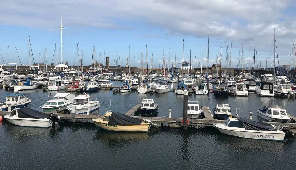
Arriving from the open cliffs of St Bees, Whitehaven feels immediately more structured and contained. Built around a planned Georgian harbour, the town’s layout, architecture and dockside setting create a clear sense of order — a contrast to the raw, natural coastline just passed.
Historically one of Britain’s most important ports, Whitehaven played a central role in trade across the Irish Sea and beyond. Today, its harbour, marina and surrounding streets reflect that past, offering a place where the story of Cumbria’s maritime connections becomes more visible and tangible.
• Historic Georgian harbour with a strong sense of place
• Key maritime centre with links to trade and industry
• Clear contrast to the surrounding natural coastline
What to See & Do
Whitehaven Harbour & Marina – The focal point of the town, with dockside walks, boats and views across the water.
Beacon Museum – A modern museum exploring the town’s maritime, industrial and social history, set overlooking the harbour.
Georgian Town Centre – Planned streets and historic buildings reflecting Whitehaven’s development as a major port.
Rum Story – A museum and visitor attraction exploring Whitehaven’s historic links to the rum trade.
Harbour Walks – Simple routes around the docks and waterfront, offering views across the marina and out to sea.
If you have time, a short inland detour from Whitehaven leads to Cockermouth (details included below), offering a different pace and a brief shift away from the coast before continuing north.
Explore Roman Britain on the West Cumbria Coast
This section of the route begins to reveal Cumbria’s Roman past, with key sites along the coast and just inland offering a glimpse into life on the western edge of the empire.
Ravenglass sits directly on the route and is one of the best-preserved Roman bath houses in northern England. From here, a short inland detour leads to Hardknott Roman Fort — dramatically positioned high in the mountains and one of the most striking Roman sites in the UK.
For this chapter, even visiting one or two of these sites can add real depth to your journey — and begins to highlight the value of an English Heritage membership as you continue north.
Annual membership starts from £53 — with 15% off using code AFFEH1526 until 31.12.2026.
Membership often pays for itself in just 2–3 visits, especially as you continue along the route.
Get 15% Off MembershipWest Cumbria & St Bees Head
Haverigg → Ravenglass → Seascale → St Bees → Whitehaven
Optional Detour — Cockermouth
If you have time, a short inland detour from the coastal route leads to Cockermouth, adding around 20–25 minutes of driving each way. It’s an easy diversion from the A595 and works well as a brief change of pace before continuing north.
Set at the meeting of two rivers, Cockermouth offers a more traditional market town feel, with historic streets, independent shops and a quieter, inland atmosphere that contrasts with the coast.
Cockermouth – Georgian Market Town & Wordsworth’s Birthplace
Cockermouthsits just beyond the western edge of the Lake District National Park, at the meeting of the Rivers Cocker and Derwent. Broader and more architectural than the mountain villages you’ve just passed through, it offers a shift in tone — Georgian streets, independent shops and a strong literary connection.
It works well as a pause point on this loop: for coffee, provisions, fuel or a short wander before returning south toward Crummock Water and Buttermere.
Birthplace of William Wordsworth
Elegant Georgian streets and riverside setting
Good cafés and independent shops
Useful stop for supplies before the quieter western lakes
Gateway to the Solway Coast (if extending the trip)
What to See and Do
Wordsworth House – The childhood home of William and Dorothy Wordsworth. Period interiors and riverside garden give context to the poet’s early life.
Cockermouth Castle (view only) – A dramatic 13th-century castle at the river confluence. Usually closed to the public but impressive from the outside.
Georgian Main Street – Independent shops, cafés and traditional façades make this one of the Lake District’s most attractive market towns.
Jennings Brewery (if open) – Local brewing heritage with tours and tastings (check availability).
Civic Trust’s town trail – Self-guided walk linking historic yards, bridges and river views.
J. B Banks Hardware store in Market Place with items depicting 200 years of history.
Lakes Distillery - A short drive away, find out how whisky is being made in a holistic way.
Kirkgate Centre - A popular arts and community centre hosting exhibitions, performances, and events.
-
Cockermouth lies along the A595, north-west of Crummock Water. The town centre is compact and easy to explore on foot.
By Road
From Whinlatter, descend to Lorton and continue north-west towards Cockermouth (approx. 20 minutes).
Car Parking
Town centre car parks are signposted on approach. Street parking is limited in peak times.
Time Needed
Coffee stop & short wander: 45–60 minutes
Wordsworth House visit: 1.5–2 hours
Full town exploration: Half day
-
William Wordsworth’s Birthplace
Cockermouth is the birthplace of William Wordsworth (1770–1850), one of the central figures of the Romantic movement and a defining voice of the Lake District.
He was born at Wordsworth House, a Georgian townhouse on Main Street, where he spent his early childhood overlooking the River Derwent. The house is now restored to reflect life in the 1770s and offers insight into his formative years.
Why It Matters
Although Wordsworth is most strongly associated with Grasmere and Rydal later in life, Cockermouth shaped his earliest memories of landscape and nature. The river, gardens and surrounding countryside influenced his lifelong fascination with childhood experience and the natural world.
His sister Dorothy Wordsworth, whose journals later documented Lakeland life in detail, was also born here.
Visiting Wordsworth House
Period rooms furnished in 18th-century style
Riverside garden recreated to reflect Georgian planting
Exhibits exploring Wordsworth’s early life
Typically 1–1.5 hours to visit
Check opening days and seasonal hours before travelling.
Cumbrian Coastal Route Last updated: 14 May 2026
Some links may earn Uncover Britain a small commission at no extra cost to you. This helps support the ongoing creation, review and presentation of our road trip guides.
Route information and listings are provided for general guidance only. Always use your preferred navigation system and check official websites to confirm suitability, opening times and the latest details before travelling.
Our guides are reviewed regularly and supported by a mix of editorial research and digital tools to help keep content clear and up to date. If you spot anything that needs updating, we’re always glad to hear from you.