Viewing as a member

Cambrian Way: Brecon Beacons
From Merthyr Tydfil: 36 miles (58 km) with drive time approx. 1 hour 20 minute
Customisable and Live Navigation via Google Maps –
click here:
Or use the link to jump to the destinations in the guide below
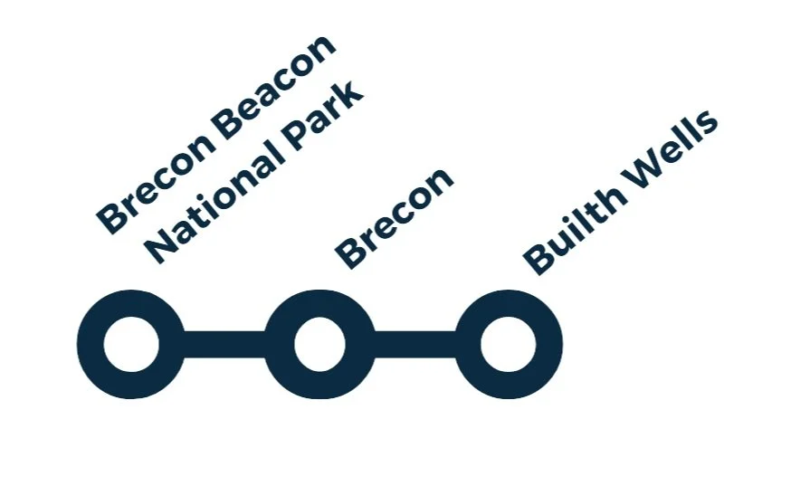
Brecon Beacons National Park →
Brecon →
Builth Wells
Part 2: The Brecon Beacons
Mountains, Market Towns & Open Skies
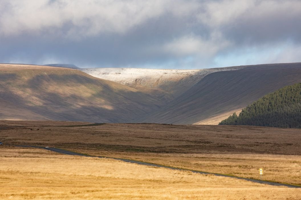
Beyond the valleys, the Cambrian Way rises into the wide, breathing spaces of the Brecon Beacons National Park. The sense of enclosure fades, replaced by long ridges, open moorland, and a landscape that feels older, calmer, and more elemental.
Here, the journey changes pace. Driving becomes more scenic, distances feel less important, and the temptation to stop — for viewpoints, short walks, and quiet exploration — becomes part of the experience. Towns like Brecon and Builth Wells sit gently within the landscape, acting as natural bases for exploring hills, rivers, and valleys rather than dominating them.
This is a section shaped by geology and water: escarpments, waterfalls, high passes, and wide skies. It’s also a place where military history, farming traditions, and outdoor culture meet. The Brecon Beacons form a natural transition zone on the Cambrian Way — leaving the industrial south behind and easing you into the deeper, wilder landscapes that lie ahead.
How to Spend Your Time
This part of your journey takes you through the rugged beauty and rich heritage of the Brecon Beacons — from windswept hilltops and shimmering reservoirs to welcoming towns filled with culture and character. Whether you're up for a full-day hike or a gentle towpath stroll, the National Park offers a wide range of ways to enjoy the outdoors.
In the historic town of Brecon, take time to explore its military past, canal walks, and peaceful cathedral. Further north, Builth Wells is a charming riverside stop with Welsh legends, craft centres, and a proud agricultural heritage at the Royal Welsh Showground.
-
Morning:
Start with a short walk or viewpoint stop in the Brecon Beacons National Park
(e.g. Storey Arms car park or Llyn y Fan Fach for a quick photo stop)Visit Carreg Cennen Castle — a spectacular hidden gem perched on a limestone cliff (allow 1–1.5 hrs)
Lunch:
Enjoy a pub lunch or picnic in the National Park, or head into Brecon town
Afternoon:
Explore Brecon Cathedral and the Canal Basin towpath (relaxing and scenic)
Optional visit to the Regimental Museum of the Royal Welsh
Evening Option:
Drive on to Builth Wells (40 mins), stopping at Llywelyn Memorial viewpoint en route
-
Day 1: Nature & Heritage in the National Park
Morning: Ride the Brecon Mountain Railway through scenic parkland
Afternoon: Enjoy a gentle walk — part of the Beacons Circuit or explore waterfalls near Pontneddfechan
Visit Carreg Cennen Castle in the late afternoon
Overnight in Brecon or a countryside inn nearby
Day 2: Discover Brecon & Builth Wells
Morning: Walk the Brecon Canal Towpath and visit Brecon Cathedral
Late morning: Stop at the Regimental Museum
Afternoon: Drive to Builth Wells, visit the Heritage Centre and Royal Welsh Showground
Enjoy riverside views or short trails before moving on or staying overnight
-
Day 1: Wild Landscapes & Hilltop Castles
Morning: Hike a section of the Beacons Circuit or enjoy a gentler trail at Craig-y-Nos Country Park
Afternoon: Discover Carreg Cennen Castle and nearby farm shop/café
Overnight in a rural cottage or Brecon
Day 2: Railways, Cathedrals & Canal Walks
Morning: Ride the Brecon Mountain Railway
Afternoon: Return to Brecon for a relaxed lunch, Cathedral visit, and towpath stroll
Optional: Evening meal by the canal or local pub stay
Day 3: Builth Wells & Hidden Heritage
Drive to Builth Wells (40 mins)
Visit the Heritage Centre, stop at Llywelyn Memorial, and explore the riverside walk
If time allows, check for events at the Royal Welsh Showground
Depart via scenic backroads or continue your route north
-
Route: Brecon → Llangorse Lake (optional detour) → Sennybridge → Upper Chapel → Builth Wells
Duration: 2–3 hours including stopsHighlights:
Stop at a scenic layby or picnic spot in the Beacons National Park
Drive past rolling hills and rural farmland through Sennybridge and Upper Chapel
Arrive in Builth Wells for a short walk or café break before continuing
This is an ideal route if you're passing through mid-Wales with limited time but still want to soak up the landscape.
How to Get There
Nestled in the foothills of the Brecon Beacons National Park, the town of Brecon offers the perfect blend of natural beauty, Welsh heritage, and small-town charm. While it feels delightfully off the beaten path, getting to Brecon is easier than you might expect — whether you're driving in from a major UK city, arriving by public transport, or flying into nearby airports.
Brecon makes a great base for exploring the national park, with hiking trails, heritage railways, and castles all within easy reach.
Although the town doesn’t have its own train station, nearby rail links combined with local buses make it accessible even if you're travelling without a car. Once you arrive, you'll find plenty of parking, a compact town centre that’s easy to explore on foot, and stunning countryside just minutes away.
-
Brecon is located just off the A470, which runs through the Brecon Beacons and connects it to the south and north of Wales. It’s a scenic drive with plenty of photo-worthy stops en route.
Approximate driving times from major hubs:
Cardiff – 1 hour 10 mins (via A470)
Bristol – 1 hr 40 mins (via M4 then A470)
Birmingham – 2 hrs 30 mins (via A40 and A438)
Manchester – 3 hrs 30 mins (via M6, A49, A40)
London – 3 hrs 30–4 hrs (via M4 then A470)
-
Brecon is a small, walkable town with plenty of public car parks, including:
Canal Road Car Park – large, central, ideal for canal walks
George Street Car Park – close to shops and cafes
Cathedral Car Park – convenient for visiting Brecon Cathedral
Rich Way Long Stay – good for full-day stops or campervans
Most car parks are pay-and-display, with coin or card options. Street parking is limited, especially in high season.
-
By Bus / Coach
National Express coaches serve Abergavenny and Merthyr Tydfil, from where you can connect to Brecon by local bus.
TrawsCymru bus services offer scenic, affordable travel across Wales:
T4 route: Cardiff → Merthyr Tydfil → Brecon → Builth Wells → Newtown
Frequent and great for road trippers without a car
Check timetables on the TrawsCymru or Transport for Wales websites.
-
Brecon does not have a train station, but you can travel to nearby stations and complete the journey by bus or taxi:
Abergavenny Station (approx. 50 mins by bus or 40 mins by taxi)
Direct trains from Cardiff, Newport, and Manchester
Merthyr Tydfil Station (approx. 45 mins by bus)
Connected to Cardiff Central by frequent local trains
Taxis are available from both stations, or combine with a scenic bus ride.
Trainline makes train and coach travel across the UK easy. Get the app to book tickets and get:
· Live times and disruptions info
· Split tickets price alerts for the cheapest tickets
· You won’t find cheaper same-day tickets than on our app or get the difference refunded.
-
Cardiff Airport (CWL) – Approx. 1 hr 20 mins by car
Domestic and European flights, car hire available on site.Bristol Airport (BRS) – Approx. 1 hr 45 mins by car
More international flights; connect via Abergavenny or Newport.Birmingham Airport (BHX) – Approx. 2.5–3 hrs by car
Ideal for northern connections and car hire.
You’ll need to hire a car or take train + bus combinations from all airports.
Brecon Beacons National Park (Bannau Brycheiniog)
Railways, Viewpoints & Easy Exploring
Brecon Mountain Railway – One of the most enjoyable ways to experience the landscape. Restored steam locomotives run from Pant (near Merthyr Tydfil), past Pontsticill Reservoir, and climb to Torpantau high in the Brecon Beacons. The return journey is around 9 miles / 14 km and offers wonderful views.
National Park Visitor Centre – Offers panoramic views, walking ideas, maps, and local information, plus tea rooms.
Walking Highlight
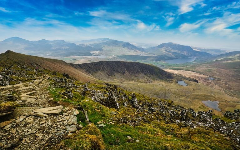
The Beacons Circuit – An 11-mile circular mountain walk taking in:
Corn Du (873m)
Pen y Fan (886m) (highest mountain in south Wales)
Cribyn (795m)
This is a classic ridge walk offering huge views, big skies, and a real sense of achievement.
Dark Sky Reserve & Stargazing
The Brecon Beacons National Park has been a Dark Sky Reserve since 2013, making it one of the best places in the UK for stargazing.
Outstanding stargazing locations include:
Llanthony Priory – A romantic ruin in a remote valley
Carreg Cennen Castle – Spectacularly positioned above a limestone cliff
Usk Reservoir – At the western end of the park beneath the Black Mountain range, offering wide open skies and minimal light pollution
On clear nights, the Milky Way, planets, and meteor showers can often be seen with the naked eye.
Overview
The Brecon Beacons National Park (Welsh: Bannau Brycheiniog) is one of the most beautiful and varied protected landscapes in the UK. It is a place of high mountains, open moorland, waterfalls, reservoirs, forests, and dark skies, offering some of the finest outdoor experiences in Wales.
The park is famous for its wide open spaces, dramatic scenery, and huge range of activities — from gentle walks and heritage railways to serious mountain hiking, climbing, and stargazing.
What to See & Do in the National Park
Outdoor Activities & Adventures
There are countless ways to enjoy the park, including:
Walking & hiking
Water sports such as kayaking, canoeing and sailing
Cantref Adventure Farm – Offers a variety of trekking experiences, including the half-day Brecon Beacons Explorer.
Parkwood Outdoors Dolygaer – An activity centre in the south of the park, about 15 minutes from Merthyr Tydfil, offering zip wire, caving and kayaking.
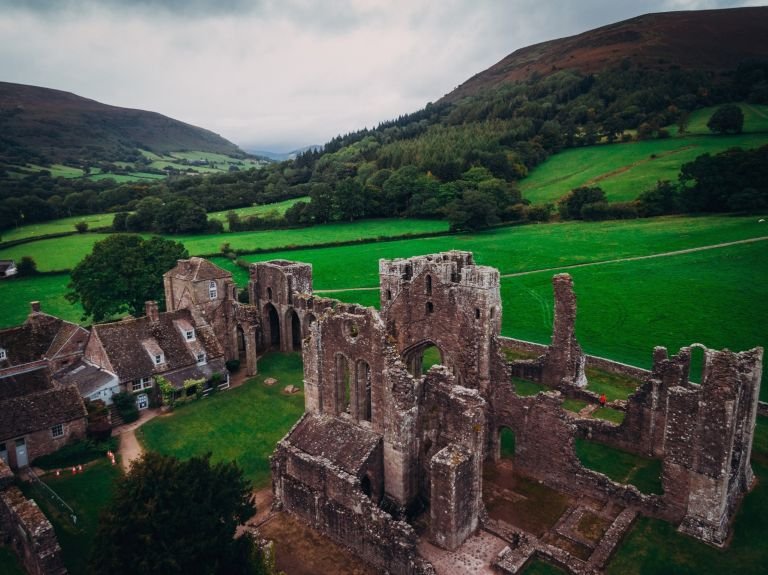
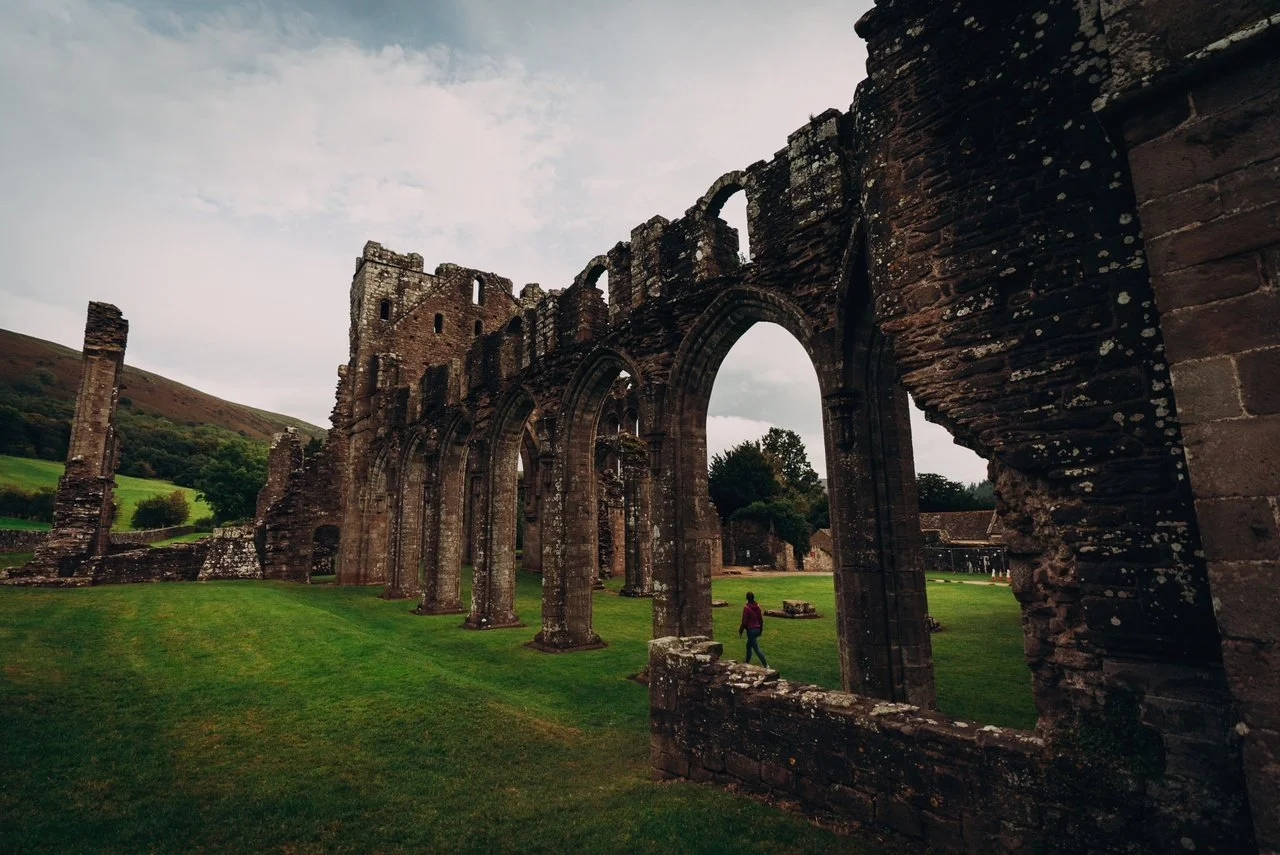
Detour to Llanthony Priory?
Llanthony Priory, lies in the remote Vale of Ewyas in the Black Mountains and is one of the most atmospheric monastic ruins in Wales. Founded in the 12th century by Augustinian monks under Walter de Lacy, it grew from a small religious cell into one of the wealthiest monastic houses in Wales.
Its isolated setting among mountains and open countryside is a huge part of its appeal.
⚠️ Important: Visiting Llanthony Priory adds around 55 miles if you then return to Brecon to rejoin the route.
What You’ll See
Visitors can explore the evocative ruins of:
The church
Cloister
Chapter house
Domestic buildings
Stars (hopefully, subject to weather and time of day!)
The site is especially popular with walkers, photographers, and history lovers.
© Crown Copyright
© Crown Copyright
-
Llanthony Priory was founded in the early 12th century by Augustinian monks, under the patronage of the Norman nobleman Walter de Lacy. Its location, deep in the remote Vale of Ewyas in the Black Mountains, was chosen for its isolation and spiritual atmosphere, but this same remoteness would also shape its turbulent history.
Originally established as a small religious community, the priory grew in wealth and importance over time and eventually became one of the more significant monastic houses in this part of Wales. However, its position close to the Welsh Marches made it vulnerable to border conflicts and raids, and the community suffered repeated attacks during periods of unrest.
Because of these difficulties, the monks at one point even abandoned the site temporarily and focused their efforts on a daughter house in Gloucester, before later returning to Llanthony.
Despite these setbacks, the priory continued to function for several centuries as a place of worship, learning, and administration, with monks engaged in prayer, study, and the management of surrounding lands.
Like many religious houses, Llanthony Priory was finally dissolved in the 16th century during the Dissolution of the Monasteries under Henry VIII. After that, the buildings fell into ruin, gradually becoming the atmospheric remains we see today.
Today, the priory is valued not only for its historical importance, but also for its extraordinary setting, which gives a powerful sense of the isolation, beauty, and hardship that shaped monastic life in medieval Wales.
-
Location:
Llanthony Priory is located in the Vale of Ewyas in the Black Mountains, on the western edge of the Brecon Beacons National Park.Important route note:
Visiting Llanthony Priory is a significant detour from the main route. If you plan to return to Brecon afterwards to continue your journey, allow for approximately an extra 55 miles of driving.Getting there:
The priory is best reached by car via narrow, scenic mountain roads.
The approach roads are steep and winding in places and form part of the experience, but take your time, especially in poor weather.
Parking:
There is parking near the priory ruins, from which it is a short walk to the site.
Access:
The site is in a remote rural setting.
Paths and ground around the ruins can be uneven and muddy, so good footwear is recommended.
Visiting time:
Allow at least 1 hour to explore the ruins, and longer if combining it with walking in the surrounding valley.
Brecon
Brecon (Welsh: Aberhonddu) is a historic market town in the heart of the national park, founded around a Roman fort (c. 75 AD) at the meeting point of the River Usk and River Honddu.
It developed into an important Norman stronghold with Brecon Castle and later grew through brewing, textiles, agriculture, and improved transport links via canal and railway.
Today, it is a lively and attractive base for exploring the Brecon Beacons.
© Crown Copyright
What to See & Do in Brecon
Brecon Beacons / Bannau Brycheiniog National Park Visitor Centre – Just outside town, with walking ideas, maps and park information.
Brecon Cathedral – Founded as a priory in the 11th century, with stained glass, medieval tombs and carved woodwork. The flag carried at Rorke’s Drift can be seen here.
The Military Museum of The Royal Welsh – Covers 400 years of military history, including the Zulu conflict and both World Wars, with over 33,000 objects.
Y Gaer Museum, Art Gallery & Library– A modern cultural centre combining the former Brecknock Museum & Art Gallery with the town library.
Monmouthshire and Brecon Canal – Walk, cycle or take boat trips from the Brecon Canal Basin.
Events include:
-
Location:
Brecon sits in the heart of the Brecon Beacons / Bannau Brycheiniog National Park, at the meeting point of the River Usk and River Honddu.Getting there:
Brecon is best reached by car via the A40 and A470, which link it to Abergavenny, Builth Wells, and Merthyr Tydfil.
There is no mainline railway station in Brecon, so driving or bus travel are the most practical options.
By bus:
Regular bus services connect Brecon with surrounding towns and cities, including Abergavenny, Merthyr Tydfil, and Builth Wells.
Using Brecon as a base:
Brecon works extremely well as a base for exploring the National Park, with shops, cafés, accommodation, and easy access to both mountain and valley scenery. -
Brecon has several convenient town-centre car parks, all within easy walking distance of the main sights, shops, and the canal basin.
Good options include:
Brecon Canal Basin car park – Ideal for visiting the Monmouthshire and Brecon Canal, canal walks, and the town centre.
Town centre car parks – There are multiple public car parks around the shopping streets, cathedral area, and market area, all well signposted on arrival.
Brecon Beacons Visitor Centre – Has its own on-site parking if you are visiting the centre and starting walks from there.
Tips:
If you plan to explore the town centre, cathedral, museums, and canal, use one of the central car parks and walk between sites.
If your focus is walking in the National Park, consider parking at the Visitor Centre or at specific trailhead car parks outside the town.
-
Brecon (Welsh: Aberhonddu) began life as a Roman settlement, built around a fort established around 75 AD to control routes through this part of Wales. The Romans chose the site because it sits at the strategic meeting point of the River Usk and the River Honddu, a natural crossroads for movement through the region.
After the Norman conquest, the town became an important border stronghold. Brecon Castle was built in the late 11th century to secure control of the area, and the town developed around it as a military, administrative, and trading centre. During the medieval period, Brecon grew into a significant market town serving the surrounding upland farming communities.
In the 18th and 19th centuries, Brecon’s role shifted again. Although it was never an industrial giant like Merthyr Tydfil, it became an important market, administrative, and transport hub, helped by the arrival of the canal and later the railway, which connected it to the wider Welsh and English economy.
Today, Brecon’s streets, cathedral, and mix of historic buildings reflect these many layers of history — from Roman frontier town, to Norman stronghold, to Georgian and Victorian market centre — making it one of the most characterful towns in the Brecon Beacons.
-
This gentle walking route introduces you to Brecon’s historic heart, cathedral, rivers, and canal, and works perfectly as a relaxed half-day activity.
1) Start: Brecon Cathedral
Begin at Brecon Cathedral, one of the town’s most important historic buildings. Take time to explore the interior, including the medieval tombs, stained glass, and the famous flag carried at Rorke’s Drift.
From here, walk down towards the town centre.
2) The Historic Town Centre & Market Area
Stroll through the town centre streets, taking in the mix of Georgian and Victorian buildings, small shops, cafés, and market spaces. This is the historic commercial heart of Brecon and still feels very much like a traditional market town.
If you wish, make a short detour to:
Y Gaer Museum, Art Gallery & Library – For a quick cultural stop
Or continue towards the canal
3) Monmouthshire & Brecon Canal Basin
Head to the Brecon Canal Basin, where the Monmouthshire and Brecon Canal ends. This is a peaceful and scenic area with narrowboats, towpaths, and waterside views.
You can walk a short stretch of the canal towpath, which is flat and very easy going, before looping back towards the river.
4) Riverside Walk Along the River Usk
From the canal area, pick up riverside paths along the River Usk. This is a lovely, quiet section of the walk, with open views and a strong sense of Brecon’s natural setting within the National Park.
Follow the riverside path back towards the cathedral area.
5) Finish: Back Near the Cathedral or Town Centre
The route naturally loops back towards the cathedral and town centre, where you’ll find plenty of cafés, pubs, and places for lunch or tea.
Practical Notes
Distance: Short and flexible — easily adjusted to suit your time and energy
Difficulty: Easy, mostly flat
Surface: Pavements, riverside paths, canal towpath
Best for: First-time visitors, gentle exploration, combining history and scenery
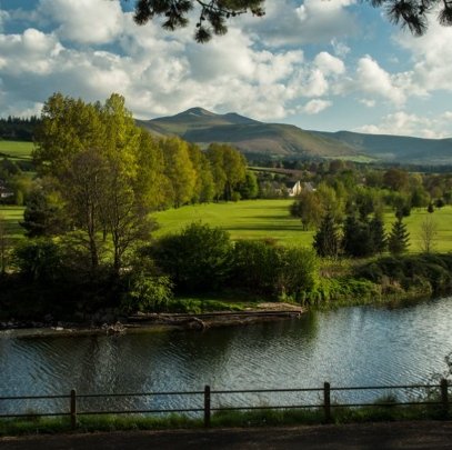
Builth Wells

© Crown Copyright
Builth Wells is best known as the home of the Royal Welsh Showground, one of the most important agricultural and events venues in the UK. Set on the River Wye in Mid Wales, the town combines a relaxed small-town feel with a surprisingly lively calendar of events and a beautiful countryside setting.
The town centre is compact and easy to explore, with independent shops, cafés, and regular markets creating a friendly and welcoming atmosphere. It also works well as a base for exploring the surrounding countryside, with riverside walks, cycling routes, and easy access to the wider landscapes of mid Wales.
What to See and Do in Builth Wells
Visit the Royal Welsh Showground (see below), famous for hosting the Royal Welsh Show as well as many other agricultural shows, exhibitions, festivals, and events throughout the year.
Explore the town centre and browse independent shops, cafés, and local markets.
Visit Builth Wells Heritage Centre to learn about the history of the town and surrounding area through interactive exhibits and displays.
Enjoy performances, cinema, and exhibitions at the Wyeside Arts Centre in the heart of town.
Visit Builth Wells Library. for a quiet break or to see local community exhibitions and events.
Discover traditional craft skills at the Alex Allpress Pottery School & Studio, which offers handmade stoneware and pottery courses.
Play a round at Builth Wells Golf Club, set in attractive countryside.
Walk along the River Wye, or enjoy fishing and gentle riverside walks in and around the town.
Royal Welsh Showground

© Crown Copyright
The Royal Welsh Showground is a 150-acre events complex located just outside Builth Wells and is one of the most important venues of its kind in Wales. It plays a major role in celebrating and promoting Welsh agriculture, rural life, and culture, and hosts a wide range of large-scale events throughout the year.
The showground is best known as the home of the Royal Welsh Show, one of the biggest and most prestigious agricultural shows in Europe, but it also hosts many other exhibitions, festivals, trade fairs, equestrian events, and concerts.
Rather than being a traditional visitor attraction, the site comes alive when events are taking place, drawing visitors from across Wales and the UK.
What to See and Do
Attend the world-famous Royal Welsh Show, featuring livestock competitions, forestry, horticulture, crafts, countryside sports, food, and entertainment.
Visit other major events throughout the year, including:
Agricultural and equestrian shows
Trade fairs and exhibitions
Festivals and concerts
Explore the exhibition halls, show rings, and outdoor display areas during events.
For multi-day shows, use the camping and caravan facilities and enjoy the full event atmosphere.
-
Location:
The showground is located just outside Builth Wells in mid Wales and is well signposted from the town and surrounding main roads.Getting there:
By car: The easiest way to reach the showground. Follow local and event signage rather than sat-nav during major events.
By train: The nearest station is Builth Road, a few miles from the site, with taxi and bus connections during major shows.
By bus: During large events such as the Royal Welsh Show, special shuttle services and extra local buses often operate from Builth Wells and nearby towns.
-
The showground has extensive on-site parking, opened and managed specifically for each event.
For major events, parking is clearly marshalled and well signposted on approach roads.
In many cases, parking is included in or managed alongside event tickets.
Tips:
Arrive early for major events to avoid queues.
Follow event signage and steward directions rather than sat-nav instructions.
Expect a lot of walking inside the showground — it covers around 150 acres, so comfortable footwear is recommended.
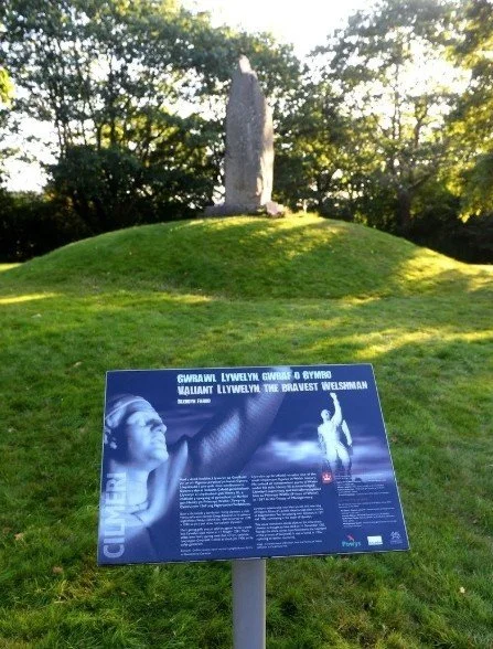
The Llywelyn Memorial
© Crown Copyright
-
Llywelyn ap Gruffudd (c. 1223–1282), often known as Llywelyn the Last, was the final native Prince of Wales and one of the most important figures in Welsh history.
He was the grandson of Llywelyn the Great and rose to power during a period of constant conflict between Welsh princes and the English crown. By 1258, he was styling himself Prince of Wales, and in 1267 the English king Henry III formally recognised his title in the Treaty of Montgomery, making Llywelyn the only Welsh ruler ever to be officially acknowledged as Prince of Wales by an English monarch.
Llywelyn spent much of his rule trying to unite Wales and defend its independence from English control. However, when Edward I came to the English throne, relations deteriorated rapidly. Edward launched a series of invasions of Wales, gradually stripping Llywelyn of territory and power.
In 1282, Llywelyn joined a renewed Welsh uprising led by his brother Dafydd ap Gruffudd. During the campaign, Llywelyn was betrayed and ambushed near Cilmeri, close to present-day Builth Wells. He was killed in the skirmish, and his head was sent to London as a warning to others.
His death marked the effective end of independent Welsh rule. Within a year, Edward I had completed the conquest of Wales, and the title Prince of Wales was later adopted by the English crown.
Today, Llywelyn is remembered as a symbol of Welsh independence and resistance, and the memorial at Cilmeri stands as one of the most poignant historical sites in Wales.
-
Location:
The Llywelyn Memorial is located at Cilmeri, a small village just west of Builth Wells, beside the River Wye.Getting there:
Best reached by car from Builth Wells — it is only a short drive.
Follow local signs for Cilmeri and the memorial site.
Parking:
There is parking near the memorial, with a short, easy walk to the monument.
On arrival:
The memorial is in a quiet, rural riverside setting.
Paths are generally easy and short, but may be muddy after wet weather.
Visiting time:
Allow 20–40 minutes for a visit, or longer if combining it with a walk along the river.
Good to know:
This is a place of reflection rather than a large attraction — there are no visitor facilities on site, so it’s best combined with a visit to Builth Wells.
Just west of Builth Wells is the The Llywelyn Memorial at Cilmeri, marking the place where Llywelyn ap Gruffudd, the last native Prince of Wales, was ambushed and killed in 1282. His death marked the end of Welsh independence and remains one of the most important symbolic sites in Welsh history.
The memorial is a quiet, reflective place to visit and adds an important historical dimension to any stay in the area.
Cycling Nearby: Sustrans Route 8
If you want to cycle, the Sustrans Route 8: Llanelwedd to Cardiff
For cyclists, Sustrans Route 8 passes close to Llanelwedd to Cardiff and forms the final southern section of the route, running south through the Brecon Beacons and the Valleys before continuing on to Cardiff. It’s a good option for linking Builth Wells into a longer-distance cycling journey.
Uncover More Map
The Uncover More map highlights key points of interest, scenic viewpoints, hidden gems, and much more along the recommended route. To make the most of it, use the map in conjunction with the destination information, and explore additional options in the area you’re visiting to discover even more experiences.
If your iPhone doesn’t load via the Google Map App via the button, check out the Help page for how to update your phone or copy and paste the link into your browser: bit.ly/Cambrian-uncover
Cambrian Way Last updated: 13 January 2026
Some links may earn Uncover Britain a small commission at no extra cost to you. This helps support the ongoing creation, review and presentation of our road trip guides.
Route information and listings are provided for general guidance only. Always use your preferred navigation system and check official websites to confirm suitability, opening times and the latest details before travelling.
Our guides are reviewed regularly and supported by a mix of editorial research and digital tools to help keep content clear and up to date. If you spot anything that needs updating, we’re always glad to hear from you.