
Cotswolds Road Trip Map
Cotswolds Road Trip Map: Explore Our Scenic Driving Route
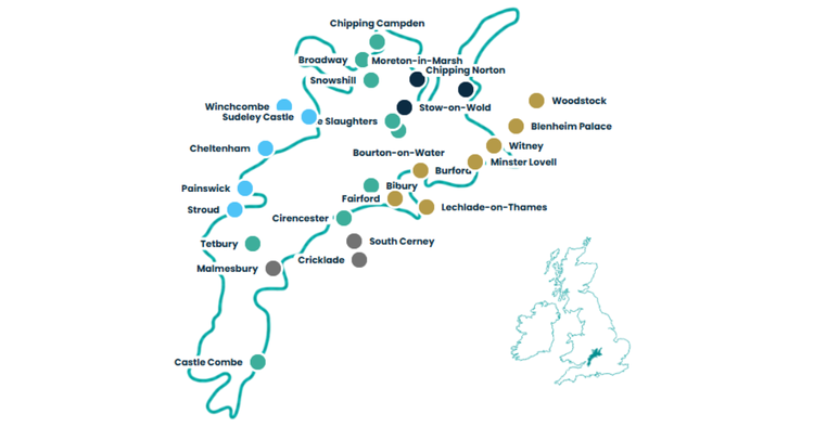
Looking for a Cotswolds road trip map? Our route connects famous villages, historic market towns, scenic valleys, country estates and quieter countryside through a Grand Spine and four flexible driving loops.
The route runs through the heart of the Cotswolds, linking places such as Chipping Campden, Broadway, Bourton-on-the-Water, Bibury, Cirencester and Castle Combe, with optional loops towards Blenheim Palace, Cheltenham, Stroud and riverside towns.
Use the map to understand how the region fits together, then use the full Uncover Britain guide to decide which villages, attractions, scenic roads and quieter stops are worth your time.
The route explained
What Does Our Cotswolds Road Trip Route Cover?
Our Cotswolds driving route is built around a north-to-south Grand Spine through some of the region’s best-known villages and landscapes.
It begins around Chipping Campden and Broadway, continues through the northern and central Cotswolds towards Bourton-on-the-Water, the Slaughters and Bibury, then travels south through Cirencester and Tetbury towards Castle Combe.
Four optional scenic loops branch away from that central route, opening up more of the Cotswolds around Moreton-in-Marsh and Chipping Norton, Burford and Blenheim Palace, Cheltenham and the western valleys, and the lakes and riverside towns of the south.
A Cotswolds route map makes it much easier to see how the famous villages and quieter areas fit together without treating each place as an isolated day trip.
Explore the journey
See How the Cotswolds Driving Route Fits Together
The journey combines one central route with four optional scenic loops, making it easy to adapt the trip around your available time and the parts of the Cotswolds you most want to explore.
What the full guide adds
Turn the map into a road trip with:
- Destination information
- Village highlights
- Scenic driving sections
- Country homes & gardens
- Places worth exploring
- Planning maps
- Optional scenic loops
- Flexible itinerary ideas
Five flexible sections
Explore the Cotswolds Road Trip Route
Follow the Grand Spine as the backbone of the journey, then add the scenic loops that best fit your time and interests.
The Grand Spine
The main north–south Cotswolds villages route, linking Chipping Campden, Broadway, Bourton-on-the-Water, Bibury, Cirencester, Tetbury and Castle Combe.
North Cotswolds Villages
Explore Moreton-in-Marsh, Chipping Norton, Stow-on-the-Wold and the honey-stone landscapes of the northern Cotswolds.
Thames & Blenheim Corridor
A riverside and heritage loop through Burford, Minster Lovell, Witney, Woodstock, Blenheim Palace, Fairford and Lechlade.
Regency & Hidden Valleys
Discover Cheltenham, Winchcombe, Sudeley Castle, Painswick, Stroud and the quieter roads of the western Cotswolds.
Roman, Lakes & Riverside Towns
A southern Cotswolds loop around Cirencester, South Cerney, Cricklade, Malmesbury and softer open countryside.
Beyond the map
The Map Tells You Where. The Guide Helps You Decide What Is Worth Your Time.
A map can show you where Bourton-on-the-Water, Bibury, Broadway and Castle Combe sit, but it cannot tell you how much time each place deserves or which quieter roads and stops are worth including between them.
The full guide helps you understand the character of each section, choose between famous villages and quieter discoveries, and shape the journey around scenic driving, country houses, gardens, market towns, walks and overnight stops.
Use the map to see how the Cotswolds fits together. Use the guide to decide how you want to experience it.
Classic Cotswolds Road Trip Guide
Discover the places behind the route
- Written route chapters
- Grand Spine route
- Four scenic loops
- Planning maps
- Village information
- Destination highlights
- Scenic road moments
- Country homes & gardens
- Itinerary ideas
- Quieter countryside stops
- Flexible trip planning
- Mobile-friendly access
Distance
How Long Is the Cotswolds Road Trip Route?
The complete Uncover Britain Cotswolds road trip covers approximately 233 miles, or 376 kilometres.
You do not need to drive the complete route in one trip. The Grand Spine creates the main structure, while the four optional loops let you build a shorter weekend road trip or a slower multi-day Cotswolds holiday.
The distances between villages can look short on a map, but narrow lanes, parking, scenic stops and time spent exploring villages mean that a relaxed pace usually works better than trying to cover too much in one day.
Choose your pace
How Many Days Do You Need for a Cotswolds Road Trip?
The route can be adapted from a single focused day to a slower week exploring villages, countryside and scenic loops.
1 day
Focus on one area, such as the northern villages or a selected section of the Grand Spine.
2–3 days
Follow the Grand Spine and add one or two scenic loops for a relaxed Cotswolds weekend.
4–5 days
Add Blenheim Palace, western valleys, southern towns, gardens and quieter countryside.
7+ days
Travel slowly, linger in villages and include more walks, attractions, gardens and scenic detours.
Route geography
Places on Our Cotswolds Road Trip Map
The route connects some of the best-known Cotswolds villages with market towns, historic estates and quieter countryside.
Before you go
Planning a Cotswolds Road Trip by Car
The Cotswolds is ideal for flexible self-drive travel, but realistic pacing makes the experience much better.
When planning your route, think about:
- how many days you have
- which famous villages matter most to you
- which scenic loops you want to add
- parking and busy village times
- country houses, gardens and attractions
- walks, pubs and scenic stops
- where you want to stay overnight
- whether you prefer highlights or quieter places
More Cotswolds inspiration
Continue Planning Your Cotswolds Road Trip
Quick answers
Cotswolds Road Trip Map FAQs
Can I see a Cotswolds road trip route on a map?
Yes. The map on this page shows the broad structure of our Cotswolds road trip, with a central Grand Spine and four optional scenic driving loops through villages, market towns, valleys and countryside.
What is the best driving route through the Cotswolds?
There is no single road through the whole region. Our route uses a north-to-south Grand Spine through key villages, with optional loops into the northern Cotswolds, Blenheim and the Thames corridor, western valleys and the southern Cotswolds.
Which villages are on the Cotswolds road trip map?
The route includes Chipping Campden, Broadway, Bourton-on-the-Water, the Slaughters, Bibury, Stow-on-the-Wold, Burford, Tetbury and Castle Combe, alongside market towns, estates and quieter countryside stops.
How long is the Cotswolds road trip?
The complete Uncover Britain route covers approximately 233 miles, or 376 kilometres, although you can use individual sections or loops for a much shorter trip.
How many days do you need for a Cotswolds road trip?
One day works for a focused section, while two to three days gives a better pace for the Grand Spine and one or two loops. Four to five days allows more time for scenic drives, gardens, Blenheim Palace, market towns and quieter valleys.
Is the Cotswolds best explored by car?
A car makes it much easier to connect the villages, scenic lanes, country estates and quieter valleys, particularly if you want to explore beyond the busiest destinations and travel at your own pace.
What does the full Cotswolds guide add to the map?
The map shows how the route fits together. The full guide adds destination information, route chapters, scenic driving sections, planning maps, village highlights, country homes, gardens, itinerary ideas and optional loops to help you decide what is worth including.
Turn the Cotswolds Map Into Your Road Trip
See how the villages and scenic loops fit together, then use the full Classic Cotswolds Road Trip Guide to choose the places, roads, attractions and quieter discoveries that make the journey your own.