Viewing as a member

Kent: White Cliffs, Castles & the Cinque Ports

Approx. 58 miles (93 km) with drive time approx. 2 hours 15 mins from Ramsgate
Sandwich > Deal > Dover > Dover Castle > White Cliffs > St Margaret’s Bay > Folkestone Harbour Arm > Dungeness
White Cliffs, Castles & the Cinque Ports
South of Thanet, the coastline becomes more elemental. Medieval Sandwich and Deal reflect the legacy of the Cinque Ports, once central to England’s coastal defence and trade. Tudor artillery forts stand directly on the shoreline, reminders that this stretch of coast has long been a frontier.
Then the land rises sharply at Dover. The White Cliffs dominate the skyline, and Dover Castle commands the heights above the Channel. The mood shifts from seaside charm to national symbolism and strategic history.
From there, the route gradually loosens again. Folkestone’s Harbour Arm introduces modern coastal reinvention, and the journey concludes at Dungeness — a vast shingle expanse of lighthouses, fishing boats and open sky that feels stark, quiet and almost otherworldly.
This final section adds scale and perspective. It moves from fortified coast to elemental landscape, ending the journey at the very edge of England.
How to Spend Your Time – White Cliffs, Castles & the Cinque Ports
This final stretch of the Kent Coast Road Trip carries more weight — historically and visually. The mood shifts from seaside energy to fortified coastline, rising cliffs and long Channel views. Towns feel older, the architecture more defensive, and the landscape increasingly symbolic.
Although the total drive time is only around 2 hours 15 minutes, this section should not be rushed. Dover Castle alone can take half a day. The White Cliffs demand walking time rather than a quick viewpoint stop. Dungeness at the southern end works best when you allow space to absorb its unusual, open landscape.
The chapter moves in a clear progression: medieval Sandwich, seafront Deal, commanding Dover, then onwards to exposed headlands and the stark shingle of Dungeness.
This section suits travellers who enjoy history, coastal walking, castles and wide, elemental scenery.
At a Glance
Driving time (without stops): around 2 hours 15 minutes
Distance: 58 miles (93 km)
Recommended time: 1–2 days
Best for: castles, clifftop walking, Tudor forts, maritime heritage, dramatic coastal landscapes
-
Start in Sandwich, allowing time to wander its medieval streets and riverside quays. Continue to Deal for a walk along the seafront and a short stop at Deal Castle.
Drive to Dover Castle, allowing at least 2–3 hours to explore the fortress, wartime tunnels and panoramic viewpoints.
Finish the day with a walk along the White Cliffs of Dover — even a short section from the visitor centre offers expansive views across the Channel.
This option covers the key historic landmarks but keeps the pace active.
-
Day 1 – Medieval & Maritime Kent
Explore Sandwich properly in the morning. Continue to Deal for seafront walking and castle visits. Spend the afternoon at Dover Castle, finishing with sunset views from the White Cliffs.Day 2 – Headlands & Open Horizons
Visit St Margaret’s Bay for a quieter cliffside pause, then continue to Folkestone Harbour Arm for lunch and sea views. End the journey at Dungeness, where the landscape flattens into vast shingle, lighthouses and open sky.This approach allows each landscape to breathe and avoids compressing too much into a single afternoon.
-
If time allows, consider:
Walking a longer section of the White Cliffs coastal path
Exploring all three Tudor artillery forts (Deal, Walmer and Sandown)
Visiting Dover’s Western Heights for additional defensive history
Timing Dungeness for late afternoon light, when the shingle landscape feels most atmospheric
The Cinque Ports - England’s Medieval Naval Powerhouse
Long before England had a standing navy, it relied on a powerful alliance of coastal towns to defend its shores. Known as the Cinque Ports, this medieval confederation formed the backbone of the kingdom’s maritime strength from the 11th century onwards.
The original five ports were:
Hastings
New Romney
Hythe
Dover
Sandwich
These towns were granted extraordinary privileges by the Crown in exchange for one essential duty: providing ships and crews for national defence. When the king called, they were required to supply fully equipped vessels within days. Before the Royal Navy existed, this system determined whether England could defend itself at all.
In return, the Cinque Ports enjoyed rare freedoms — tax exemptions, self-governance, their own courts, and representation in Parliament. They were not simply ports; they were semi-autonomous power centres controlling trade, taxation and naval response at the narrowest crossing to continental Europe.
Geography Changed Their Fate
The story of the Cinque Ports is also the story of a coastline that moved.
Silting rivers and shifting shorelines gradually altered their fortunes. Sandwich, once a major seaport, now lies inland. New Romney was once directly on the sea — today it sits miles from open water. Power ebbed not because of defeat, but because geography changed.
Strength, Smuggling & Sovereignty
The Cinque Ports were not always obedient defenders. Their naval strength gave them influence — and occasionally independence that bordered on defiance. Smuggling, privateering and selective loyalty to the Crown formed part of their character.
They were vital — but not always easily controlled.
The Cinque Ports on This Road Trip
This Kent Coast route passes through five towns connected to the Cinque Ports confederation:
Sandwich - Once among the most important ports in medieval England. Its preserved street plan reflects its former wealth and maritime prominence.
Deal - Developed as a defensive shoreline settlement, strengthened by Henry VIII’s artillery forts.
Dover - The most strategically dominant of all. Its castle, cliffs and harbour controlled the narrowest point of the Channel.
Margate - Originally a limb of Dover, later evolving from working port to seaside resort.
Folkestone - Another limb port, now balancing harbour heritage with modern coastal revival.
A Living Legacy
The title Lord Warden of the Cinque Ports still exists today, with the official residence at Walmer Castle near Deal. The role has been held by figures such as the Duke of Wellington and Winston Churchill — a reminder that this medieval alliance remains woven into Britain’s constitutional story.
Why This Matters on the Journey
Understanding the Cinque Ports transforms this stretch of coast.
Sandwich reveals medieval trade power.
Deal shows Tudor artillery defence.
Dover represents fortress-scale military dominance.
Margate and Folkestone show how naval towns evolved with time.
What appears at first glance to be a varied coastline of marshland, shingle and chalk cliffs is in fact the historic frontline of England’s maritime survival.
This is not simply a scenic coastal drive. It is the defensive backbone of medieval England — where geography, power and sea routes shaped the nation’s future.
Sandwich - Medieval Streets, River Quays & Cinque Ports Heritage
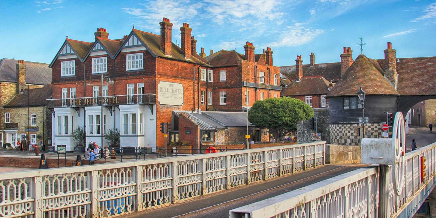
Image copyright SandwichIsOpen
Sandwich is one of the best-preserved medieval towns in Kent and one of the original Cinque Ports. Once a major trading harbour, it stood directly on the sea before the coastline gradually shifted. Today the River Stour winds quietly through the town, bordered by timber-framed houses, ancient gates and brick façades that feel largely unchanged for centuries.
The historic core is compact and atmospheric. Narrow streets lead to hidden courtyards, medieval churches and remnants of the old town walls. Unlike busier seaside resorts, Sandwich feels inward-looking and reflective — a place where the architecture tells the story.
Exceptionally well-preserved medieval street plan
Strong Cinque Ports and maritime heritage
Easy access to Sandwich Bay and coastal walking
What to See & Do
Wander through the historic centre around the Guildhall and St Peter’s Church, exploring narrow lanes lined with timber-framed buildings. Look out for Fisher Gate, one of the surviving medieval gateways.
Visit the Sandwich Guildhall Museum, housed in a 16th-century building, to understand the town’s role in trade, maritime defence and local industry. Step inside St. Peter's Church to see Norman and Gothic architectural features, medieval monuments and stained glass.
Walk along Sandwich Quay beside the River Stour, where boats still moor and the landscape opens towards the marshes. Boat trips occasionally operate along the river in season.
Just south of town, explore Sandwich Bay — a wide stretch of coastline backed by dunes and nature reserve. It offers expansive views towards the white cliffs and is popular for walking and birdwatching.
Golf enthusiasts may recognise Royal St. George's Golf Club, one of the world’s most prestigious links courses and host of multiple Open Championships.
If visiting in summer, the Sandwich Festival brings the town to life with live music, food stalls and heritage-themed events.
For longer walks, the Saxon Shore Way and the National Cycle Route 1 pass through the area, linking town, coast and countryside.
-
Location: East Kent, just inland between Ramsgate and Deal
Parking:
Gazen Salts car park (large riverside option)
Guildhall car park (central)
Additional smaller car parks and limited on-street parking (check restrictions)
Parking is generally easier here than in the coastal towns during peak season.
Access:
Compact and walkable historic centre
Mostly flat terrain, suitable for relaxed exploration
Facilities:
Public toilets near the town centre
Independent cafés, tearooms and pubs
Small shops and local businesses rather than large retail chains
Best Time to Visit:
Morning for quieter streets and museum access
Combine with Deal or Dover as part of a full-day exploration
Sandwich works best as a slower, architectural counterpoint to the White Cliffs and coastal fortresses further south — a medieval anchor point before the coastline begins to rise and harden into battlements and chalk cliffs.
-
Perfect for a morning or afternoon visit
Explore the medieval town centre – Walk the cobbled streets lined with half-timbered houses and crooked windows. Don’t miss King Street, Church Street, and Potter Street for classic photo spots.
Visit the Guildhall Museum to discover the town’s long maritime and civic history.
Take a riverside walk along the River Stour or around the old town walls and gates, some of which date back to the Norman period.
Pause for tea or lunch at a traditional café or pub, such as The King’s Arms, The Hop and Huffkin, or No Name Shop.
-
The most popular tourist attraction in Sandwich is the medieval town itself—its remarkably well-preserved historic centre is the main draw. Visitors come to wander the narrow lanes, admire the timber-framed buildings, and soak up the atmosphere of one of the best-kept medieval towns in England.
This self-guided walking route through Sandwich that highlights the timber-framed buildings, narrow medieval lanes, and includes a visit to the Guildhall Museum. The route is short and easy (about 1–1.5 hours at a gentle pace), perfect for a morning or afternoon stroll.
Timber Frames & Medieval Streets
Start: Guildhall Car Park or Sandwich Railway Station
Distance: ~1 mile circular loop
Time: 60–90 minutes at a relaxed pace1. Guildhall Museum (CT13 9AH)
Begin your walk at the Guildhall, a 16th-century timber-framed civic building at the heart of Sandwich.
Step inside the Guildhall Museum (allow 30–45 minutes) to explore Sandwich’s story—from its Roman origins to medieval trade, shipbuilding, and smuggling.
Don’t miss the Mayor’s Parlour, courtroom, and local artefacts like the Sandwich Magna Carta copy.
🡆 Exit the museum and turn onto Cattle Market.
2. King Street
Walk south along King Street, one of the most atmospheric roads in town.
Look out for half-timbered houses, overhanging jettied upper floors, and old shopfronts.
Many buildings date back to the 15th and 16th centuries—look for carved beams and crooked lines.
🡆 Continue to the end of King Street and turn left onto Strand Street.
3. Strand Street
This is one of the longest unbroken stretches of timber-framed houses in England.
Walk slowly and admire how the houses lean and bend—some are over 600 years old.
Look for number plaques and blue information signs, often with the building’s age or former use.
🡆 Turn left onto Potter Street, another charming lane with quirky cottages and hanging signs.
4. St Peter’s Church & Market Street
Potter Street leads you to St Peter’s Church, once used by Flemish refugees.
Climb the church tower (if open) for views across the town and surrounding marshes.
Explore the Market Street area for independent shops and small cafés tucked among the historic buildings.
🡆 Turn left onto No Name Street (yes, really!) and follow it to New Street.
5. Barbican Gate & Town Walls
End your loop by heading toward the Barbican Gate, one of the last surviving gateways into Sandwich.
From here, you can walk a short stretch of the old town walls and look out across the River Stour.
Optional Finish:
Enjoy a drink or cream tea.
Alternatively, head to the Quay for riverside views and pub lunches
From Sandwich to Deal
Leaving Sandwich, the road gradually returns you to the sea. Medieval brick and timber give way to open marshland, low skies and glimpses of distant coastline. The landscape flattens as you pass through countryside that once formed part of the town’s original harbour approach.
Within a few miles, the character shifts again. The inland quiet of Sandwich gives way to a linear seafront and wide shingle beach. Where Sandwich feels enclosed and historic, Deal feels open and outward-facing — its long promenade running parallel to the Channel, its Georgian terraces aligned confidently along the shoreline.
The transition is subtle but distinct. You move from medieval Cinque Port to coastal defence and Regency elegance. By the time you reach Deal’s seafront, the mood has changed from river quays and town gates to sea walls, artillery forts and uninterrupted views across the water.
Deal marks the point where the Kent coast begins to feel more strategic — a prelude to the White Cliffs rising further south.
Deal - Georgian Seafront, Tudor Castles & Unspoilt Coastal Character
Deal stretches along a wide shingle shoreline facing the Channel, its elegant Georgian terraces aligned confidently along the sea. Unlike larger resort towns, Deal feels refined and lived-in — a place where fishing boats still rest on the beach and the promenade remains the focal point rather than arcades or amusements.
Historically, Deal was a key defensive and maritime centre. Its position along the Cinque Ports coastline made it strategically important, and Henry VIII’s coastal fortifications still anchor the shoreline. Today, the town blends architecture, maritime heritage and independent character with open coastal views.
Long, uninterrupted seafront promenade and historic pier
Henry VIII’s Deal Castle and nearby Walmer Castle
Independent High Street with strong local identity
What to See & Do
Walk the length of Deal’s seafront promenade for expansive views across the Channel. On clear days you can see along the coast towards the White Cliffs. Stroll out along Deal Pier — one of the UK’s oldest surviving pleasure piers — for panoramic coastal views and a different perspective back towards the town.
Visit Deal Castle (see below), a striking Tudor artillery fort built in the 16th century as part of Henry VIII’s defensive chain. Continue south to Walmer Castle, once the residence of the Lord Warden of the Cinque Ports, with formal gardens softening its military architecture.
Wander Deal’s High Street, lined with historic buildings, antique shops, art galleries, traditional bakeries and independent cafés. The town rewards slow browsing rather than rushing between attractions.
Explore the Deal Maritime and Local History Museum to learn about fishing, smuggling and naval warfare, or visit the Deal Timeball Tower Museum, an important 19th-century maritime navigation landmark.
For outdoor exploration, follow sections of the Saxon Shore Way or the Viking Coastal Trail which pass through Deal and link it to neighbouring towns. Golfers may recognise Royal Cinque Ports Golf Club and Prince’s Golf Club — both renowned links courses with tournament history.
Visit the Deal Timeball Tower Museum, housed in a historic maritime tower dating back to 1820. Learn about the town's maritime history and the role of the timeball tower in maritime navigation.
Throughout the year, Deal hosts events including the Deal Festival of Music and the Arts and the annual Deal Carnival, adding cultural depth beyond its seafront setting.
-
Location: East Kent coast, between Sandwich and Dover
Parking:
Middle Street car park (central)
Deal Castle car park (close to seafront and castle)
South Street car park
Limited on-street parking (check restrictions)
Parking can be busy during summer and event weekends but is generally manageable outside peak periods.
Access:
Flat promenade suitable for easy walking
Shingle beach — sturdy footwear recommended if walking on the beach
Facilities:
Public toilets near the seafront
Wide range of independent cafés, pubs and restaurants
Shops concentrated along High Street
Best Time to Visit:
Clear days for uninterrupted Channel views
Late afternoon for softer light along the promenade
Check local events calendar if visiting in festival season
Deal works as a balanced coastal stop — offering architecture, fortifications, maritime heritage and simple seafront walking — before the coastline rises more dramatically towards Dover and the White Cliffs.
-
Perfect for a morning or afternoon visit
History & Harbourfront Charm
Start at Deal Castle – Explore the remarkable Tudor fortress by the sea. Wander its underground tunnels, climb the bastions, and admire the sea views. (Allow 1–1.5 hours)
Walk the Seafront Promenade – From the castle, stroll along the wide walkway toward Deal Pier.
Deal Pier – Take in the views or enjoy a coffee at the café at the end of the pier.
High Street Browsing – Spend a little time in Middle Street and the independent shops, antique stores, and delis on the high street.
Optional: Grab lunch, cake, or a pint at The Rose, The Black Douglas, or The No Name Shop.
-
Castles, Clifftops & Coastal Charm
Distance: ~1.5 miles (2.4 km)
Duration: ~1.5–2 hours
Start/End Point: Deal Castle or Middle Street Car Park
Best for: History lovers, architecture fans, and coastal walkers1. Deal Castle (CT14 7BA)
Start your tour at Deal Castle, built by Henry VIII. Walk around the moat to admire its rose-shaped design before heading inside to explore the gun bastions, ramparts, and tunnels. Allow 45 minutes if you plan to visit.
🡆 Exit via the seafront path.2. Deal Seafront & Promenade
Walk north along the wide promenade, passing colourful fishing boats and beach huts. Look back to see the castle’s rounded walls rising from the shingle.
🡆 Continue until you reach Deal Pier.
3. Deal Pier
Take a stroll along the modern concrete pier, built in the 1950s. At the end, stop at the Deal Pier Kitchen for a coffee with a panoramic view of the coast and town rooftops.
4. Beach Street & High Street
Turn inland at the foot of the pier and head onto Beach Street, where Georgian townhouses line the road. Then, explore High Street and Queen Street, filled with independent shops, galleries, antique stores, and bakeries.
Optional stop: Deal Timeball Tower Museum (if open), just off the promenade, tells the story of Deal’s maritime past.
5. Middle Street & Conservation Area
Head into the Middle Street Conservation Area, one of Deal’s most charming quarters. This warren of narrow lanes and brick-and-flint cottages reveals what Deal looked like in the 18th and 19th centuries. Look out for:
The Old Blue Plaques on former smugglers' houses
St George’s Church tower peeking above the rooftops
Hidden courtyards and maritime motifs
6. Local Pubs & Hidden Cafés
Pause at The King’s Head or The Bohemian for a drink, or find lunch at Frog & Scot, The Lane, or The Rose Hotel. Many places offer sea views or garden seating.
7. Deal Town Hall & Victoria Park (Optional Extension)
If you’d like to extend your walk, head inland to Deal Town Hall, then stroll through Victoria Park for a bit of greenery and local life.
🡆 Loop back to the seafront to end your walk where you began.
Want to Keep Going?
To Walmer Castle: Continue south along the promenade (30-minute seafront walk)
To Sandown or the countryside: Head inland for cycling paths and nature reserves
-
Saxon Shore Way
Type: Long-distance walking trail
Total Length: Approx. 163 miles (262 km)
Best for: Walkers interested in history and coastlineThe Saxon Shore Way follows the line of Roman-era coastal defences that once protected south-east England from seaborne raiders. From Deal, the route runs north towards Sandwich and Pegwell Bay, or south towards Dover and the White Cliffs.
From Deal, you can:
Walk north (towards Sandwich)
A flatter, marshland section with wide skies and estuary views. This links naturally back to Sandwich Quay and the River Stour.Walk south (towards Dover)
More dramatic. The path gradually climbs as it approaches the White Cliffs, offering increasingly expansive Channel views.This is a true walking trail rather than a casual promenade route. It suits those wanting longer-distance hiking or historical context layered into their coastal walking.
Viking Coastal Trail
Type: Circular walking & cycling route
Total Length: Approx. 32 miles (51 km) loop
Best for: Cycling, family rides, shorter scenic sectionsThe Viking Coastal Trail is a circular route around the Isle of Thanet and along the coast between Ramsgate, Broadstairs, Margate and back towards Reculver — extending south towards Deal.
From Deal, you can join it heading north towards Sandwich and then onwards to Ramsgate, effectively linking the Cinque Ports stretch with the Thanet coastline.
This route is:
More accessible for cyclists
Well signposted
Generally flatter and easier-going
It works well if you want to explore sections by bike rather than on foot.
Which Should You Choose from Deal?
For clifftop drama and historical depth: Saxon Shore Way (south towards Dover)
For cycling or linking back towards Thanet: Viking Coastal Trail
For a gentler riverside walk: Saxon Shore Way north towards Sandwich
Deal sits at a junction point between marshland, cliffs and peninsula — making it a practical place to branch into longer coastal exploration beyond the core road trip route.
Deal Castle - Henry VIII’s Tudor Coastal Fortress
Deal Castle is one of the finest surviving Tudor artillery forts in England. Built in 1539 on the order of Henry VIII, it formed part of a chain of coastal defences designed to protect England from invasion by France and the Holy Roman Empire.
Its distinctive circular design — with a central keep surrounded by concentric defensive walls and gun platforms — was built specifically to mount heavy cannon facing the Channel. Unlike many ruined coastal forts, Deal Castle remains remarkably intact, allowing visitors to explore multiple levels and understand how it functioned as a working fortress.
-
Deal Castle was built in 1539–1540 by order of King Henry VIII as part of a chain of coastal defences (known as the Device Forts) designed to protect England against invasion from France and the Holy Roman Empire.
It’s one of the finest and best-preserved examples of a Tudor artillery castle, along with nearby Walmer and Sandown (now lost). Its rose-shaped design is both beautiful and brutal—built low to the ground and designed to withstand cannon fire, with multiple tiers of gun ports to defend against land and sea attacks.
Though it never saw a major battle, Deal Castle has served military roles over centuries—from the English Civil War to World War II, when it was manned for coastal defence.
-
Explore the Castle’s Unique Design
Wander through the central keep and its six rounded bastions, laid out like a Tudor rose.
Look out over the sea from the gun platforms, and imagine the thundering cannons once mounted here.
Descend into the Dark Tunnels
The atmospheric basement-level gun gallery is a favourite feature—walk the narrow stone passages and defence tunnels that curve around the outer wall.
Kids and adults alike love the slightly eerie, immersive feel (bring a jumper—it’s cool down there!).
Step Inside the Story
The castle features interpretive displays and hands-on exhibits throughout the inner chambers. Learn about Henry VIII’s turbulent reign, the building of the Device Forts, and Deal’s strategic role over centuries.
There’s also a short audio-visual introduction to set the scene.
Walk the Ramparts
Take in panoramic views of the English Channel from the top level. On a clear day, you can spot shipping lanes and maybe even France.
The outer moat and grassy banks offer scenic spots to walk or sit—ideal for photos and a peaceful pause.
-
Location: Victoria Road, Deal, Kent, CT14 7BA
Managed by: English Heritage
Opening Hours:
Typically open daily from spring to autumn, 10am–5pm (check English Heritage website for seasonal updates).
Closed or reduced hours during winter.
Tickets:
Adults: ~£8–10
Children: Free with adult ticket
Free for English Heritage members
Tickets available on the day or online
♿ Accessibility:
Some areas are wheelchair accessible, but the tunnels and upper levels involve steps and uneven surfaces.
Accessible toilets available.
Tips for Visiting
Allow 1–1.5 hours for a full visit
Combine with a walk to Walmer Castle (~30 mins along the seafront)
Bring a torch or phone light for the tunnels if you want to explore thoroughly
Perfect for families, history buffs, or a coastal day out

Image copyright English Heritage
From Deal to the White Cliffs
Leaving Deal, the coastline gradually begins to rise. The long, level promenade gives way to a more exposed shoreline, and the sense of open sea becomes stronger. The road south follows the Channel closely, passing quieter stretches of beach before the land ahead begins to lift.
The change is unmistakable. What has been a horizontal coastline starts to tilt upward. Chalk becomes more visible. The air feels sharper, the views wider. This is the point where the Kent coast stops being simply scenic and becomes iconic.
The White Cliffs rise ahead — bright, sheer and unmistakable.
The White Cliffs of Dover - National Icon, Chalk Headland & Channel Views

The White Cliffs of Dover are more than a postcard image. Rising dramatically above the Channel, they form one of Britain’s most symbolic landscapes — a place of arrival, departure and defence for centuries.
The best way to experience them is not from a roadside pull-in, but on foot. The drama lies in walking the cliff-top paths, feeling the wind off the sea, and looking across the world’s busiest shipping lane towards France on clear days.
What to See & Do
Start at Langdon Cliffs Visitor Centre
Begin at the White Cliffs of Dover Visitor Centre on Langdon Cliffs. This is the main access point and the ideal place to orient yourself. From here, wide clifftop paths stretch east and west, with panoramic views over the English Channel.
Spend time simply watching the ferry and cargo traffic below — Dover’s strategic importance becomes immediately obvious.
Walk to South Foreland Lighthouse
Follow the clifftop path east towards South Foreland Lighthouse. The walk is one of the most rewarding stretches on the Kent coast.
The lighthouse itself is notable for being the first in the world to use electric light and for its role in early radio navigation experiments by Guglielmo Marconi. Visitors can climb the tower (seasonal opening) and enjoy tea in the cliff-top garden café.
Allow 60–90 minutes return walking time, longer if you stop frequently for views.
Visit the Fan Bay Deep Shelter
A short detour along the path leads to the Fan Bay Deep Shelter (seasonal opening). Guided tours take you down into a network of WWII tunnels carved directly into the chalk. Inside, bunks and interpretation panels tell the story of soldiers stationed beneath the cliffs during wartime.
This adds depth to the visit — transforming the cliffs from scenery into strategic defence.
Optional Detour: Samphire Hoe
For a completely different perspective, drive to Samphire Hoe, a nature reserve created from Channel Tunnel excavation spoil. Here you walk at sea level, looking up at the towering white cliffs from below.
It is flatter, quieter and more sheltered — ideal if the cliff-top winds are strong.
-
Main Access:
White Cliffs Visitor Centre (Langdon Cliffs)Parking:
National Trust car park (charges apply for non-members)
Parking fills quickly in summer and at weekends — arrive early
Terrain:
Well-maintained cliff-top paths
Some uneven surfaces and exposed edges
Not fully pushchair-friendly
Facilities:
Visitor centre café
Toilets
Gift shop
Time Needed:
Minimum: 1 hour
Ideal visit: 2–3 hours including lighthouse walk
Add 45–60 minutes if visiting Fan Bay ShelterSafety:
Stay well back from cliff edges. Chalk cliffs are unstable and subject to erosion.
From the White Cliffs into Dover
Leaving the open headland, the path and road begin to descend. The wide horizon narrows, the wind softens, and Dover town gradually comes into view below. From the cliff edge, the harbour appears first — ferries moving in and out, cranes and breakwaters shaping the shoreline.
Then, above it all, Dover Castle dominates the skyline.
Where the White Cliffs represent natural defence, Dover Castle represents engineered power. The transition feels intentional: from raw chalk escarpment to one of England’s most important fortresses. You move from symbolic landscape to strategic stronghold within a matter of minutes.
The cliffs give you perspective. Dover gives you context.
Together, they explain why this stretch of coast has mattered for centuries.
Dover - White Cliffs, Wartime Tunnels & England’s Strategic Frontier

Dover is far more than a ferry port. For over two millennia it has stood as Britain’s front line — a place of arrival, invasion, defence and departure. From Roman armies landing on its shores to medieval kings fortifying its heights, from Napoleonic anxieties to the evacuation of Dunkirk, Dover’s position facing continental Europe has shaped its identity at every stage of history.
Chalk cliffs rise sharply above the harbour, their brightness visible for miles out at sea. Above them, fortifications crown the hills — Dover Castle dominating the skyline, Western Heights stretching along the ridge, and hidden tunnels running beneath the chalk. The town below reflects this layered past, with Roman remains, medieval buildings and wartime infrastructure woven into its streets.
Whether you have a few hours or a full day, Dover rewards structured exploration rather than casual wandering. The key is to think in layers: begin with the cliffs for perspective, move to the castle for power and strategy, explore the town for Roman and civic history, and finish with the Western Heights for panoramic context. Seen this way, Dover is not just a stop on the coast — it is the strategic heart of the Kent shoreline.
-
Location: South-east Kent, directly on the A2 with strong road links from London and Canterbury
Parking
Dover is easier for parking than Thanet’s coastal towns, but planning ahead is useful, especially in summer.
For Dover Castle:
Dedicated Dover Castle car park (signposted from A2)
This is the most convenient option if visiting the castle first.
For White Cliffs (Langdon Cliffs):
National Trust car park (charges apply for non-members)
Arrive early in peak season — it fills quickly.
For Dover Town Centre & Museums:
Pencester Road car park
Bench Street car park
Marine Parade (near harbour)
For Western Heights:
Small roadside and Drop Redoubt car parks (limited capacity)
Getting Around
The castle and Western Heights are uphill from the town centre
White Cliffs access requires driving out of town
Walking between sites is possible but involves steep climbs
Many visitors choose to drive between the Cliffs, Castle and Western Heights rather than walk.
Suggested Visit Timing
Minimum: 3–4 hours
Ideal: Half to full dayDover works best when structured into zones — Cliffs, Castle, Town, Western Heights — rather than attempting everything in quick succession.
-
How to Spend a Half Day in Dover
Perfect for a quick visit or passing through
Castle & Cliffs (Choose One Main Highlight)
Option 1: Dover Castle Focus
Spend 2–3 hours exploring Dover Castle—the town’s most iconic site
See the medieval keep, WWII Secret Wartime Tunnels, and enjoy sweeping views across the Channel
Finish with lunch or tea at the on-site café
Option 2: White Cliffs & Walk
Walk part of the White Cliffs of Dover National Trust trail from the Visitor Centre
Stop at Fan Bay Deep Shelter if open (WWII tunnel system carved into the cliffs)
Enjoy clifftop views and watch ferries glide into the port
How to Spend a Full Day in Dover
Ideal for history lovers, walkers, and first-time visitors
Morning:
Arrive early at Dover Castle and allow 3+ hours to explore
Don’t miss: the Secret Wartime Tunnels, Roman Lighthouse, and medieval Great Tower
On a clear day, you can see France across the Channel
Lunch:
Grab a bite at the castle café, or head into town for lunch at Il Rustico, The White Horse, or Marine Court for sea views
Afternoon:
Head to the White Cliffs Visitor Centre (by car or short walk/drive)
Walk to South Foreland Lighthouse or St Margaret’s Bay
Optional stop at Fan Bay Deep Shelter (pre-book if possible)
Evening (optional):
Watch the sunset from the cliffs or enjoy a drink on Dover Marina
-
Dover is a town and major port in Kent, on the English Channel. It is the nearest port to mainland Europe and has been one of the most important ports in Britain since Roman times.
The town has a long and rich history, dating back to the Iron Age. It was a major trading port during the Roman Empire and was later used by the Saxons and the Vikings. In the Middle Ages, Dover was a major stronghold for the English crown and was besieged by the French on several occasions.
The town played an important role in the English Civil War and was captured by the Parliamentarians in 1642. It was later recaptured by the Royalists in 1648. Dover was also a major port during the Napoleonic Wars and was defended by a number of forts, including Dover Castle.
The town continued to be an important port during the Victorian era and was used to transport goods and people to and from Europe. Dover was also a major military base during the First and Second World Wars.
What To See & Do
Dover works best when approached in zones rather than rushing between sites.
Clifftop & Strategic Views - (See above) Experience the headland first — either before or after the castle — to understand Dover’s geographic importance.
Dover Castle (See Below) - Dover Castle deserves dedicated time. It contains, The Great Tower (medieval royal keep), Roman lighthouse (one of the oldest in Britain), Napoleonic tunnels, Wartime Tunnels Collection (Dunkirk evacuation operations) and PWRR & Queen’s Regiment Museum. Allow 2–4 hours minimum.
Roman & Medieval Dover - After the castle, walk into town to explore deeper history.
Roman Painted House - A remarkably preserved 3rd-century Roman building, believed to have served elite travellers arriving from the Continent.
Dover Museum - Home to the internationally significant Bronze Age Boat and artefacts spanning prehistoric to medieval Dover.
Maison Dieu Hall - Originally a medieval pilgrim hostel, later a Royal Navy victualling yard, now Dover’s civic hall — architecturally striking and historically layered.
Western Heights Fortifications - For those wanting fewer crowds and dramatic views:
Western Heights of Dover - These 18th–19th century defences were built to deter Napoleonic invasion. Explore moats, bastions and the Drop Redoubt while enjoying sweeping views over the port.
Further Interest (If You Have More Time)
Dover Transport Museum – nostalgic vintage vehicles and recreated streets
Kent Battle of Britain Museum Trust – world’s largest Battle of Britain collection
Dover Castle - Visiting the “Key to England”

Perched high above the White Cliffs with commanding views over the English Channel, Dover Castle is one of the most important and complete fortresses in England. Often called the “Key to England,” it has guarded this narrow stretch of sea for over 900 years — though the site itself has been defended for nearly two millennia.
The castle is not a single building but a vast complex. At its heart stands the Great Tower, a mighty Norman keep built for Henry II in the 12th century. Around it lie medieval curtain walls, gun batteries, underground tunnels, and even a Roman lighthouse — one of the oldest surviving in Britain.
What makes Dover Castle exceptional is the layering. You can walk through Roman history, medieval power, Napoleonic military planning and World War II command operations in one continuous visit. Beneath the castle, the Wartime Tunnels reveal how the site served as a military command centre during the Dunkirk evacuation and throughout the Second World War.
This is not a quick photo stop. Dover Castle demands time. The grounds are expansive, the interiors immersive, and the views across the Channel are as much part of the experience as the stone walls themselves.
Allow at least 2–3 hours for a meaningful visit — longer if you wish to explore the tunnels, museums and defensive earthworks fully.
Dover Castle is the strategic and architectural climax of the Kent Coast Road Trip — where natural defence meets engineered power, and centuries of history stand visibly layered above the sea.
-
Dover Castle stands as one of the most iconic and strategically important fortresses in England. Perched high on the White Cliffs, it has guarded the narrowest part of the English Channel for nearly 1,000 years. Its commanding position earned it the nickname “The Key to England.”
Construction began in the 11th century, shortly after William the Conqueror’s victory in 1066. The site had long been a place of military significance—Roman and Saxon remains can still be seen today. The castle was later transformed by King Henry II in the 12th century, who built the impressive Great Tower (or Keep), designed as a symbol of royal authority and a comfortable royal palace.
Over the centuries, Dover Castle evolved in response to new threats:
During the Napoleonic Wars, engineers dug a vast network of tunnels into the cliffs for troops and supplies.
In World War II, these tunnels were repurposed as a secret wartime command centre, playing a vital role in Operation Dynamo, the Dunkirk evacuation in 1940.
Dover Castle has also captured imaginations through the screen, featuring in films such as The Other Boleyn Girl and Into the Woods.
-
The Great Tower
Step into the richly furnished medieval Great Tower to explore the world of King Henry II. Actors in period costume bring history to life, and the rooms are set as they might have been in the 12th century.Secret Wartime Tunnels
A highlight of any visit – descend into the cliffs and tour the atmospheric tunnels.Napoleonic Tunnels: Originally dug to house soldiers in the 18th century.
WWII Tunnels: Discover command rooms, a military hospital, and soundscapes that recreate the tension of wartime decision-making.
Battlements & Views
Walk the castle walls and take in sweeping views across the English Channel—on a clear day, you can even spot France.Roman Lighthouse & Saxon Church
Don’t miss the Roman Pharos, the oldest standing Roman building in Britain, and the Saxon Church of St Mary in Castro, both located within the castle grounds.Interactive Exhibits & Events
English Heritage runs exhibitions, children’s trails, and seasonal reenactments. There’s something for every age and interest. -
Location: Castle Hill Road, Dover CT16 1HU
Managed by: English HeritageOpening Times:
Seasonal hours apply – typically open daily from 10am to 5pm. Closed on select holidays. Always check the website before visiting.Admission:
Ticketed entry – English Heritage members go free. Pre-booking recommended during weekends and holidays.Facilities:
Café and picnic areas
Gift shop
Toilets and baby changing
Parking available (fee may apply)
Dogs not permitted in most buildings (except assistance dogs)
Access Tips:
The site is large and on uneven terrain—allow at least 2–3 hours for your visit.
There are steps in many areas, though accessible paths and shuttle options are available for visitors with mobility needs.
From Dover to St Margaret’s Bay
Leaving Dover, the road climbs once more. Harbour cranes and ferry terminals fall behind, and the landscape opens back out into chalk headland and rolling coastal downs. The sense of urban defence softens, replaced by open grassland and quieter lanes winding along the cliff edge.
Within a short distance, the scale changes again. The fortress dominance of Dover gives way to something more secluded. The cliffs remain high, the sea just as close, but the atmosphere becomes calmer and more residential. St Margaret’s Bay sits tucked into a natural curve of the coastline, sheltered beneath steep chalk slopes and reached by a narrow descent towards the shore.
Where Dover feels strategic and monumental, St Margaret’s feels intimate. It is still part of the same dramatic chalk coastline, but here the emphasis shifts from battlements and battalions to quiet shoreline, sea views and a gentler pace.
This short stretch marks a subtle but important shift — from national symbol to hidden coastal cove — before the journey continues west towards Folkestone and, eventually, the wide shingle expanse of Dungeness.
Dover & the White Cliffs: England’s Most Iconic Castle
This section of the journey centres on Dover — home to one of the largest and most historically important castles in England, overlooking the White Cliffs and the English Channel.
Dover Castle alone typically costs £25+ per person, with its medieval fortress, wartime tunnels and panoramic coastal views.
Adding nearby sites such as Richborough Roman Fort makes membership one of the most cost-effective ways to explore this part of Kent.
Annual membership starts from £53 — with 15% off using code AFFEH1526 until 31.12.2026.
Membership often pays for itself in just 2–3 visits.
Get 15% Off MembershipSt Margaret’s Bay - Sheltered Cove Beneath the White Cliffs

St. Margaret’s Bay sits quietly between Dover and Folkestone, tucked into a natural curve of chalk cliffs just below South Foreland. Smaller and more secluded than the White Cliffs viewpoint, it offers a gentler perspective on this dramatic coastline — less symbolic, more personal.
The bay has long attracted writers, artists and high-profile residents seeking privacy and inspiration. During World War II it was known as “Hellfire Corner” because of its proximity to the Channel front line. Among its most famous former residents was Ian Fleming, creator of James Bond, who lived nearby and drew inspiration from the coastal setting.
St Margaret’s is not about grand landmarks. It is about atmosphere — chalk slopes rising behind you, sea stretching ahead, and a sense of being slightly removed from the busier world above.
Sheltered pebble bay beneath high chalk cliffs
Direct access to dramatic clifftop walking
Strong wartime and literary connections
What to See & Do
Walk along the pebble shoreline and take in views across the Channel — on clear days, the French coastline is visible. The setting feels enclosed yet expansive, with chalk cliffs framing both sides of the bay.
Climb or follow the paths towards the clifftops, where you can join the coastal trail linking back towards the White Cliffs or onward to South Foreland. The headland walks here are some of the most dramatic on the Kent coast, with open skies and constant sea views.
Visit St Margaret’s Museum (small but worthwhile), with displays on local history and the area’s links to notable residents including Ian Fleming and Noël Coward.
Look out for remnants of wartime defences scattered along the cliffs — quiet reminders of the area’s frontline role during World War II.
Above the bay stands South Foreland Lighthouse — the first lighthouse in the world to use electric light and an important site in early radio transmission experiments by Marconi. The lighthouse offers guided tours (seasonal) and a tearoom with cliff-edge views.
-
By Car
St Margaret’s Bay is just 10–15 minutes from Dover by car via the A258, a winding coastal road that offers glimpses of countryside and sea along the way. If you're travelling from Deal, the bay is about 20 minutes away via the same route in the opposite direction.
The final approach is a steep descent into the bay area—take care, especially in wet weather.
By Bus
Regular Stagecoach bus services run between Dover and Deal, stopping at St Margaret’s at Cliffe village. From there, it’s a 15–20-minute downhill walk to the bay.
Buses such as the 80 and 81 operate most days, though timetables may vary on weekends and holidays.
Be prepared for an uphill return walk or time your visit with return bus services.
On Foot
For keen walkers, St Margaret’s Bay is accessible via the White Cliffs walking trail from Dover or South Foreland Lighthouse.
The coastal walk from Dover takes about 1.5 to 2 hours, passing dramatic chalk cliffs and sea views along the way.
From South Foreland Lighthouse, it’s a 15–20-minute walk down into the bay via a steep footpath.
By Bike
Cyclists can reach the bay from either Dover or Deal via local roads and lanes, though the final descent is steep. It’s a popular stop on longer cycling routes along the Kent coast or National Cycle Network paths.
-
Practical Information for Visiting
Location: East of Dover, between Dover and Folkestone
Parking:
St Margaret’s Bay car park (National Trust)
Limited roadside parking in the village (check restrictions)
Parking is limited and fills quickly in summer.
Access:
Steep road descent into the bay
Pebble beach — sturdy footwear recommended
Cliff paths exposed in windy conditions
Facilities:
Public toilets (seasonal)
Beach café (seasonal opening)
Additional facilities in nearby Dover
Best Time to Visit:
Clear days for Channel views
Quieter mornings or late afternoons
St Margaret’s Bay works best as a slower, atmospheric pause after Dover’s scale and symbolism — a sheltered cove that brings the dramatic chalk coastline down to human level before the journey continues towards Folkestone and the wide horizons beyond.
From St Margaret’s Bay to Folkestone
Leaving St Margaret’s Bay, the road climbs steadily back onto the chalk ridge. The enclosed cove disappears behind you, replaced once again by open headland and long Channel views. This stretch feels less fortified than Dover and less secluded than St Margaret’s — the coastline begins to broaden, and the sense of exposure softens.
As you continue west, the cliffs gradually lower and the landscape shifts from raw chalk to a more settled coastal edge. Housing appears along the slopes, the seafront widens, and Folkestone begins to take shape ahead — its harbour arm projecting into the sea.
Where St Margaret’s feels tucked away and reflective, Folkestone feels outward-looking and re-energised. The mood transitions from wartime memory and hidden bays to creative revival and contemporary coastal life.
This short drive marks another subtle evolution along the Kent coast — from defensive headland to working harbour reinvented for a new era.
Folkestone - Harbour Arm Revival, Creative Quarter & Channel Views

-
Folkestone is a town, located on the English Channel, about 10 miles (16 km) from Dover. Folkestone has a long and rich history. It was founded by the Romans in the 1st century AD, and was later used by the Saxons and the Vikings. In the Middle Ages, Folkestone was a major port and trading centre. The town was also a popular destination for pilgrims, who would come to visit the shrine of Saint Eanswythe.
Folkestone continued to be an important port during the Tudor and Stuart periods. Folkestone was once a favourite of King Edward VII, this formerly grand seaside resort. The town was also a popular resort for wealthy Londoners. In the 18th century, Folkestone became a fashionable seaside resort. The town was home to several elegant hotels and guesthouses and was a popular destination for bathing, boating, and fishing.
Folkestone's fortunes declined in the 19th century, as the town was bypassed by the railway. However, the town's fortunes revived in the 20th century, as Folkestone became a popular destination for day-trippers from London. The town was also home to many military installations and was heavily bombed during the Second World War.
After the war, Folkestone underwent a period of regeneration. The town's seafront was rebuilt, and several new hotels and guesthouses were opened. Folkestone also became a popular destination for artists and writers.
-
Folkestone has several convenient car parks near the town centre, seafront, and key attractions.
🔹 Best Car Parks:
Leas Cliff Hall Car Park (CT20 2DZ)
Ideal for visiting The Leas Promenade, Lower Leas Coastal Park, and the clifftop area.Harbour Arm Car Park (CT20 1QH)
Closest to Folkestone Harbour, Sunny Sands Beach, and the Harbour Arm dining and event spaces.Payers Park (CT20 1BT)
Central and a good option for the Creative Quarter, High Street, and Folkestone Museum.Pleydell Gardens Car Park (CT20 2DN)
A quieter option, just a short walk from the town centre.
🅿️ Blue Badge parking is available at all council-run car parks. On-street pay-and-display spaces are available near The Leas and in the Creative Quarter, though they fill quickly in summer.
-
Distance: ~2 miles (3.2 km)
Duration: ~1.5 to 2 hours
Best for: First-time visitors, casual walkers, photographers, and art loversRoute Overview:
Start at The Leas Promenade
Begin your walk at this beautiful Victorian promenade designed by Decimus Burton, with benches, flower beds, and sweeping views over the English Channel.Descend into the Lower Leas Coastal Park
Take one of the zig-zag paths down to the gardens, playground, and seaside café. Pause for a coffee or stroll along the coastal trail.Continue along the seafront to Sunny Sands Beach
Follow the seafront path to Sunny Sands, Folkestone’s main sandy beach, great for paddling and photography.Explore the Harbour and Harbour Arm
Wander along the marina, then head onto the Harbour Arm, now home to street food, bars, and pop-ups inside converted railway buildings. Look out for murals, live music, and art installations.Head into the Creative Quarter
Climb the steps from the Harbour to Tontine Street and The Old High Street, where you’ll find art galleries, quirky shops, and artist studios. Pop into a gallery or stop for a snack at one of the cafés.Optional Stop: Folkestone Museum
Finish your walk with a visit to Folkestone Museum, where you can learn about the town’s fishing heritage, wartime history, and its evolution into a cultural hub.
-
Perfect for a morning or afternoon visit
Start at The Leas Promenade for sea views and a gentle walk
Visit the Lower Leas Coastal Park – explore the gardens or let children play
Stroll to the Harbour and Harbour Arm for a bite to eat or coffee by the sea
Wander through the Creative Quarter and browse local shops and galleries
Optional: Relax at Sunny Sands Beach or enjoy ice cream on the seafront
Seafront Strolls & Coastal Views
Start with a walk along The Leas Promenade, a sweeping clifftop path offering panoramic views over the English Channel. Designed in the mid-1800s by Decimus Burton, this elegant promenade is perfect for a relaxed stroll, with plenty of benches and gardens along the way.
Just below, the Lower Leas Coastal Park offers a lush, family-friendly retreat featuring landscaped gardens, a café, picnic spots, and the southeast’s largest free adventure playground. Public art installations and coastal trails make it a peaceful yet playful place to explore.
For more natural beauty, head to The Warren, a dramatic coastal nature reserve of chalk cliffs, woodlands, and secluded beaches. It’s a haven for walkers, birdwatchers, and those looking to escape into nature just minutes from the town.
Beaches & Water Activities
Sunny Sands Beach is Folkestone’s popular town beach, ideal for families and sunseekers. Located near the harbour, it’s one of the few sandy beaches in the area and is backed by cafés, shops, pubs, and convenient facilities—making it a great spot for a full beach day.
Adventure seekers can try kayaking, paddleboarding, or cycling along the scenic coastal trails, with equipment hire and guided tours available locally.
Harbour Life & The Harbour Arm
Folkestone Harbour has been transformed from a historic ferry port into a charming marina and cultural destination. Stroll along the waterfront to see moored boats and watch the tide ebb and flow.
Don’t miss the Harbour Arm, a vibrant hub of converted railway buildings now home to independent eateries, bars, pop-ups, and event spaces. Once the departure point for soldiers heading to the Western Front during WWI, the Arm is now a place to enjoy street food, live music, and sunsets over the sea.
The Creative Quarter & Arts Scene
Folkestone is known for its artistic energy, best experienced in the Creative Quarter, a lively neighbourhood of colourful shopfronts, studios, and galleries. Browse independent boutiques, discover local makers, and take in the town’s quirky, imaginative atmosphere.
Visit the Folkestone Creative Foundation to see contemporary exhibitions and learn about the town’s ambitious arts initiatives. If you're in town during the Folkestone Triennial, look out for large-scale public art installations and sculptures scattered across parks, buildings, and even the beach.
History & Heritage
Dive into Folkestone’s past at the Folkestone Museum, located in the former town hall. Through interactive exhibits and fascinating artefacts, you’ll discover the town’s evolution from a humble fishing village to a strategic coastal town during World War II.
Battle of Britain Memorial - Clifftop Tribute Above the Channel
Located at Capel-le-Ferne just outside Folkestone, the Battle of Britain Memorial stands high above the Channel on the white cliffs, marking one of the most strategic stretches of coastline in 1940. From here, RAF pilots flew daily to defend Britain during the Battle of Britain — one of the defining air campaigns of the Second World War.
The memorial is centred around a striking statue of a seated pilot, helmet resting beside him, gazing out across the sea towards France. The setting is deliberate and powerful: the Channel directly below, shipping lanes beyond, and the same horizon once crossed by enemy aircraft.
Unlike a conventional museum, this is first and foremost a place of reflection.
Dramatic clifftop setting overlooking the Channel
Moving tribute to “The Few” who fought in 1940
Combined memorial garden and exhibition space
-
Location: Capel-le-Ferne, between Folkestone and Dover
Parking:
Dedicated on-site car park (free, donations encouraged)
Access:
Mostly flat memorial grounds
Cliff-edge paths — exposed in strong winds
Facilities:
Visitor centre and exhibition space
Café (seasonal hours may vary)
Toilets on site
Time Needed:
45 minutes to 1.5 hoursThe Battle of Britain Memorial works particularly well when combined with Folkestone or Dover. It adds a deeply human layer to the defensive story already told by the White Cliffs and Dover Castle — moving the narrative from fortresses and tunnels to the young airmen who defended the skies above them.
From Folkestone to Dungeness
Leaving Folkestone, the coastline begins to open and flatten. The chalk cliffs that have dominated the horizon for miles gradually lower, and the landscape shifts from headland and harbour to wide, exposed shoreline. The road turns west, following the edge of Romney Marsh — a broad, low-lying expanse that feels markedly different from the fortified heights of Dover.
This stretch of the journey is quieter and more spacious. The sea remains constant, but the scenery becomes more elemental. Fewer terraces cling to the cliffs, fewer fortifications crown the hills. Instead, long horizons and open skies take over.
As you approach Dungeness, the transformation is complete. The dramatic white cliffs of east Kent give way to one of the most unusual coastal landscapes in Britain — a vast shingle headland scattered with fishing boats, lighthouses and weathered cottages. The scale feels horizontal rather than vertical, stark rather than grand.
Where Dover represented strategic dominance and Folkestone creative revival, Dungeness offers something entirely different: space, silence and the raw edge of land meeting sea.
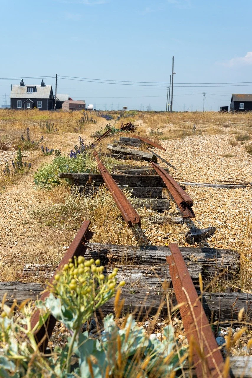
Dungeness - Shingle Headland, Lighthouses & England’s Strangest Shoreline
-
Practical Information for Visiting
Location: Southern Kent coast, at the edge of Romney Marsh
Parking:
Multiple informal roadside parking areas along the shingle road
Lighthouse car park (seasonal charges may apply)
Parking near the railway station and nature reserve
Spaces are generally easier to find than at other Kent coastal hotspots.
Access:
Mostly flat terrain
Shingle surface can be uneven — sturdy footwear recommended
Exposed to wind in all seasons
Facilities:
Lighthouse (seasonal opening)
Snack Shack and The Pilot Inn
Limited public toilets (check seasonal availability)
Best Time to Visit:
Clear days for expansive Channel views
Late afternoon for dramatic light
Quieter weekdays for a more atmospheric experience
Dungeness closes the Kent Coast Road Trip with something entirely different from what came before. After fortified cliffs and historic towns, this is open horizon and raw coastline — a place where nature, industry and art coexist in one of the most distinctive landscapes in England.
-
Distance: ~1.5 miles (2.4 km) loop
Duration: 1.5–2 hours at a slow pace
Best for: Nature lovers, photographers, and those seeking a truly unusual coastal walkRoute Overview:
Start at Dungeness Old Lighthouse – Climb to the top for 360° views across the shingle landscape, sea, and nuclear power station.
Walk along the shingle to the beach – Explore the expansive shoreline, dotted with old boats, fishermen’s huts, and artful flotsam.
Pass by Prospect Cottage – Admire the late Derek Jarman’s iconic black cottage and garden from the lane.
Continue toward Dungeness Nature Reserve – Follow a marked trail into the RSPB reserve, spotting birds, rare plants, and expansive saltmarshes.
Loop back past The Pilot Inn – Enjoy lunch, or stop at the Dungeness Snack Shack for fresh seafood with a sea breeze.
Finish at Dungeness Railway Station – Catch a miniature steam train or simply admire the quaint terminus of the Romney, Hythe & Dymchurch Railway.
-
Perfect for a quick visit or stop on a Kent coastal road trip
Climb the Dungeness Lighthouse for panoramic views
Take a short beach walk and enjoy the rugged coastal scenery
Admire Prospect Cottage and visit the nearby seafood shack or Pilot Inn for lunch
Stop by the Dungeness Railway Station for a photo or short ride (check timetable)
-
Ideal for slow travel, nature, and photography lovers
Morning:
Start at the Old Lighthouse and explore the beach
Walk to Prospect Cottage and take time to photograph the surreal landscape
Explore the RSPB Nature Reserve – follow the shingle trails and bird hides
Lunch:
Enjoy fresh seafood from the Snack Shack, or a hearty meal at The Pilot Inn
Afternoon:
Visit Dungeness Railway Station and take a miniature steam train ride
Wander further into the reserve, or explore the beach’s scattered sculptures and boat wrecks
Enjoy a sunset walk or photo session with the Power Station silhouette in the background
Dungeness does not feel like the rest of the Kent coast. After cliffs, castles and harbour towns, the land suddenly flattens into a vast, exposed shingle headland stretching out into the Channel. Bleak and beautiful in equal measure, it feels elemental — shaped by wind, tide and time rather than terraces or battlements.
This is one of the largest expanses of shingle in Europe. Fishing boats sit tilted on the stones, rusted winches rest where they were last hauled, and weathered wooden sheds punctuate the horizon. The light here is different — sharper, wider, cinematic. It is a landscape that has long attracted artists, photographers and writers seeking something raw and unfiltered.
In the distance, the stark silhouette of Dungeness Power Station rises above the shingle — a powerful industrial presence that defines the skyline and heightens the landscape’s strange, cinematic character.
Vast shingle shoreline unlike anywhere else in England
Historic lighthouse and panoramic Channel views
Unique blend of nature reserve, fishing community and industrial backdrop
What to See & Do
Walk across the shingle beach and absorb the scale of the landscape. The sea feels both close and distant, with long uninterrupted horizons. Beachcombers and photographers will find endless textures — driftwood, fishing gear, wildflowers pushing through stone.
Climb the 1904 Dungeness Lighthouse (seasonal opening) for panoramic views across the English Channel, the Romney Marsh and the stark silhouettes of the power stations that define the skyline.
Explore the Dungeness Nature Reserve, an internationally important habitat of shingle ridges, freshwater pools and salt marsh. Boardwalks and paths lead through an unusual ecosystem home to rare birds and hardy coastal plants.
Visit Prospect Cottage, former home of filmmaker and artist Derek Jarman. The black-painted cottage with yellow window frames and sculptural driftwood garden remains one of Dungeness’s most photographed landmarks (viewable from the lane; not open to the public).
Ride or visit the terminus of the Romney, Hythe & Dymchurch Railway a miniature steam railway linking Dungeness to the marshland towns beyond.
Dungeness Sound Mirrors — Hidden on the edge of Romney Marsh, these vast concrete acoustic mirrors were built in the 1920s as early-warning devices to detect incoming aircraft before the invention of radar. Stark, sculptural and slightly surreal, they sit in open grassland not far from the shingle headland. Access is by guided tour only, which adds to their intrigue. They are one of the most unusual and photogenic pieces of pre-radar military engineering in Britain.
For food, the Dungeness Snack Shack offers fresh crab rolls, lobster and seafood eaten at simple picnic tables, while The Pilot Inn provides a more traditional pub setting.
End of Chapter — White Cliffs, Castles & the Cinque Ports
This final stretch of the Kent Coast road trip brings together everything that has defined the journey so far — maritime power, shifting geography and landscapes shaped by defence.
From the medieval street plan of Sandwich to the artillery forts of Deal, from the monumental scale of Dover Castle to the exposed chalk headlands at St Margaret’s, this chapter has traced England’s historic frontline. These were not simply seaside settlements. They were fortified ports, naval providers and guardians of the narrowest crossing to continental Europe.
The coastline gradually softened as the journey moved west — from battlements and battlegrounds to harbour revival in Folkestone — before dissolving into the raw openness of Dungeness. The cliffs gave way to shingle. The vertical drama of chalk became the horizontal vastness of Romney Marsh. Power shifted from fortress to horizon.
Together, this chapter completes the historic and geographical arc of the Kent coast.
End of Road Trip — The Kent Coast
This road trip began in Canterbury, where pilgrimage, cathedral authority and medieval streets shaped the identity of the county. It followed the oyster shores of Whitstable, the creative revival of Margate, the cliff-framed bays of Broadstairs and Ramsgate, and then turned towards England’s defensive heartland.
What makes the Kent Coast distinctive is not simply its scenery, but its strategic position. For centuries this was the threshold between England and the Continent — a coastline of arrival, invasion, defence and departure. The Cinque Ports, the White Cliffs, the castle at Dover and the wartime memorials all speak to that role.
And yet the journey ends not with a fortress, but with open space.
At Dungeness, the landscape becomes elemental. Sea, sky and shingle stretch outward without walls or towers. It is a fitting conclusion — the coast laid bare, shaped by time rather than conflict.
From cathedral city to coastal headland, from oyster beds to nuclear skyline, this route reveals Kent as both gateway and frontier.
The Kent Coast is not a single seaside story.
It is England’s edge — layered, resilient and constantly changing.
Extending the Journey — Continue into Sussex
If you’re not ready to finish at Dungeness, the coastline continues seamlessly into Sussex — and the landscape changes once again.
Just beyond the Kent border lies Rye, one of the most atmospheric Cinque Port towns. From there, the coast begins to rise dramatically towards Hastings and the chalk headlands of Beachy Head.
Our Sussex Coast Road Trip picks up where Kent leaves off. Add to your account here.
While the Kent route is defined by naval power, fortifications and shifting medieval harbours, Sussex tells a broader coastal story — from Norman conquest and battlefield history to Regency elegance and open South Downs landscapes.
The Sussex Coast road trip covers approximately 140 miles (225 km) and unfolds in three distinct stages:
1066 Coast & Seven Sisters — medieval streets, battlefield heritage and bold white cliffs
Brighton & the South Downs — Regency architecture, river valleys and castle skylines
Chichester Harbour & The Witterings — tidal creeks, saltmarsh and wide sandy beaches
Where Kent feels like England’s defensive edge, Sussex feels more expansive and varied — dramatic cliffs giving way to cultured seafront towns and calmer western shores.
Together, the Kent and Sussex routes create one of the most coherent coastal journeys in southern England.
From Canterbury to West Wittering, you follow a continuous story of invasion, trade, seaside reinvention and landscape change — a coastline shaped as much by history as by tide.
Uncover More Map
The Uncover More map highlights key points of interest, scenic viewpoints, hidden gems, and much more along the recommended route. To make the most of it, use the map in conjunction with the destination information, and explore additional options in the area you’re visiting to discover even more experiences.
If your iPhone doesn’t load via the Google Map App via the button, check out the Help page for how to update your phone or copy and paste the link into your browser: https://bit.ly/kent-uncover
Kent Coast Last updated: 21 February 2026
Some links may earn Uncover Britain a small commission at no extra cost to you. This helps support the ongoing creation, review and presentation of our road trip guides.
Route information and listings are provided for general guidance only. Always use your preferred navigation system and check official websites to confirm suitability, opening times and the latest details before travelling.
Our guides are reviewed regularly and supported by a mix of editorial research and digital tools to help keep content clear and up to date. If you spot anything that needs updating, we’re always glad to hear from you.