
Cumbria coastal driving inspiration
Best Scenic Drives on the Cumbrian Coast
Explore some of the best scenic drives on the Cumbrian Coast, from Morecambe Bay and the Furness Peninsula to St Bees Head, historic harbours and the wide-open Solway Coast.
These routes reveal a quieter side of Cumbria, where tidal estuaries, sea cliffs, beaches, industrial heritage and western approaches to the Lake District create a varied self-drive journey.
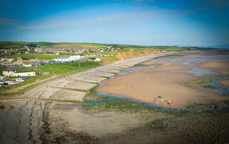
While millions of visitors head for the lakes, mountains and famous passes of the Lake District National Park, Cumbria’s western coastline remains one of England’s most rewarding places to explore by car.
Stretching from the tidal landscapes of Morecambe Bay to the expansive beaches of the Solway Coast, the Cumbrian coast offers a completely different experience. Historic harbours replace busy tourist centres, dramatic sea cliffs stand where mountain passes might normally dominate the view, and peaceful estuaries, nature reserves and coastal villages create a slower, more relaxed style of road trip.
Many travellers know parts of this coastline through the wider Cumbria Coastal Route 200, but one of its greatest attractions is how easily you can tailor your own journey. Some sections work well as a leisurely half-day drive, while others deserve a full day with time to wander around harbours, enjoy short walks or stop beside the Irish Sea.
Whether you are planning a dedicated Cumbria Coast road trip or simply adding a coastal section to a Lake District holiday, these are some of the most rewarding scenic drives along England’s north-west coast.
How many scenic sections should you drive in one day? One larger section or two shorter neighbouring sections usually creates a more enjoyable day than trying to cover the whole coastline at once.
Plan a complete Cumbria Coast road trip
Cumbria Coast Road Trip Guide
Our Cumbria Coast Road Trip Guide follows around 173 miles (278 km) through five connected sections: Morecambe Bay and the southern estuaries, Furness Peninsula and island coast, West Cumbria and St Bees Head, Solway Coast and northern shores, and Carlisle and Hadrian’s Wall.
The guide helps you understand how Cumbria’s western shoreline fits together, with written route chapters, planning maps, mapped destinations and stops, coastal scenery, heritage, wildlife and flexible trip-planning ideas.
It is an independent self-drive journey inspired by the wider Cumbria Coastal Route 200, giving you a structured route that can be adapted to your time, interests and travel style.
- A carefully planned 173-mile coastal journey
- Five connected route sections
- Written route chapters
- Planning maps
- Mapped destinations and stops
- Coastal and heritage highlights
- Scenic stops and walking ideas
- Flexible 2–14+ day pacing
- Browser-based, mobile-friendly access
- One-off purchase with 12 months’ access
 Complete digital road trip guide
Follow Cumbria’s western edge from Morecambe Bay through Furness, St Bees, the Solway Coast and Carlisle, with five flexible sections and mapped planning support.
Buy the guide — £10.99This free article provides additional scenic-driving inspiration. Not every road, stop or detour mentioned on this page is necessarily included in the paid guide. Please check the product page for the confirmed route structure and guide contents.
Morecambe Bay and the Cartmel Peninsula
Best for: estuary scenery, historic villages and relaxed coastal driving
The southern gateway to the Cumbrian coast begins beside one of Britain’s most fascinating tidal landscapes. Rather than dramatic cliffs, this section is defined by broad estuaries, changing light and peaceful roads linking elegant seaside towns with historic villages.
Beginning around Grange-over-Sands, the route follows the northern edge of Morecambe Bay before exploring the Cartmel Peninsula. Historic buildings, traditional pubs and quiet country lanes combine with sea views to create a relaxed introduction to the coast.
Drive details
- Approx. 28 miles / 45 km
- Allow half a day
- Generally suitable for most vehicles
- Some narrower lanes near Cartmel
Highlights
- Grange-over-Sands promenade
- Cartmel village
- Cartmel Priory
- Morecambe Bay viewpoints
Furness Peninsula and Roa Island
Best for: maritime heritage, sea views and hidden coastal corners
The Furness Peninsula feels completely different from the landscapes most people associate with Cumbria. This is a coast shaped by shipping, industry and the sea, yet it also offers peaceful beaches, small villages and far-reaching views across Morecambe Bay.
Driving towards Roa Island introduces one of the area’s most distinctive landscapes. Causeways, tidal waters and small harbours give this section a character unlike anywhere else in northern England.
Drive details
- Approx. 35 miles / 56 km
- Allow one day
- Exposed in poor weather
- Generally straightforward parking
Highlights
- Ulverston
- Barrow-in-Furness
- Roa Island
- Walney Channel
Duddon Estuary to Ravenglass
Best for: peaceful scenery, wildlife and estuary views
Leaving the Furness Peninsula behind, the road follows the Duddon Estuary before continuing north towards Ravenglass. It is a landscape of salt marshes, broad skies and constantly changing tidal scenery, with the western Lake District fells often forming a dramatic inland backdrop.
Millom adds industrial heritage before the route reaches Ravenglass, where three rivers meet the sea. The village’s Roman history, heritage railway and estuary setting make it one of the most rewarding stops on the whole coastline.
Drive details
- Approx. 25 miles / 40 km
- Allow half to three-quarters of a day
- Good for wildlife and photography
- Some seasonal parking restrictions
Highlights
- Duddon Estuary
- Millom
- Ravenglass
- Western Lake District access
Ravenglass to St Bees Head
Best for: dramatic coastal scenery, cliffs, walking and photography
This is one of the most memorable scenic sections on the Cumbrian coast. The road passes through quieter western landscapes before reaching St Bees, where red sandstone cliffs rise above the Irish Sea.
St Bees Head is the only Heritage Coast between Wales and Scotland. Its cliffs, seabirds and coastal paths make it an excellent place to break the drive with a short walk.
Drive details
- Approx. 22 miles / 35 km
- Allow half to a full day
- Parking available in St Bees
- Clifftop walking can be exposed
Highlights
- Ravenglass
- Muncaster area
- St Bees village
- St Bees Head Heritage Coast
Whitehaven to Maryport
Best for: historic harbours, maritime heritage and coastal towns
North of St Bees, the coastline reflects centuries of maritime trade, coal mining and shipbuilding. Whitehaven is one of England’s finest planned Georgian harbour towns, with attractive streets and a strong maritime story.
Continuing north towards Maryport reveals another historic harbour with Roman connections and an increasingly open coastal landscape.
Drive details
- Approx. 18 miles / 29 km
- Allow half a day
- Good town-centre facilities
- Useful lunch-stop section
Highlights
- Whitehaven Harbour
- Georgian architecture
- Maryport
- Roman and maritime heritage
The Solway Coast
Best for: quiet beaches, wildlife and wide-open coastal scenery
The Solway Coast feels broader and quieter than the southern sections, with salt marshes, beaches and wide views towards Scotland across the Solway Firth.
Traffic is generally light, making this one of the most relaxed scenic drives in northern England. Small villages and long stretches of open shoreline make it especially rewarding for slower travel, birdwatching and photography.
Drive details
- Approx. 38 miles / 61 km
- Allow one day
- Exposed to changing weather
- Well suited to a slower pace
Highlights
- Solway Coast National Landscape
- Long sandy beaches
- Salt marshes
- Views towards Scotland
Carlisle and the Western End of Hadrian’s Wall
Best for: Roman history, castles and completing the journey
Although the main coastal scenery ends before Carlisle, finishing the journey here gives the route a strong conclusion. Carlisle links Cumbria’s shoreline with border history and the western end of Hadrian’s Wall.
The city’s castle, cathedral and Roman connections show how the coast and frontier landscapes have shaped this part of Britain for centuries.
Drive details
- Approx. 20 miles / 32 km
- Allow half to a full day
- Good city parking and facilities
- Convenient overnight stop
Highlights
- Carlisle Castle
- Carlisle Cathedral
- Hadrian’s Wall
- Roman frontier heritage
The strongest Cumbrian Coast road trips combine one scenic driving section with time to explore on foot. Distances may look short, but estuary viewpoints, beaches, harbours and heritage stops can easily turn a brief drive into a full day.
Choose your scenic section
Which Cumbrian Coast drive should you choose?
Each section offers a different combination of scenery, history and road-trip character.
Best for dramatic cliffs
Ravenglass to St Bees Head gives the strongest combination of red sandstone cliffs, coastal walks and Irish Sea views.
Best for quiet coastal scenery
The Solway Coast offers long beaches, salt marshes, broad skies and some of the lightest traffic on the route.
Best for estuaries
Morecambe Bay and the Duddon Estuary provide constantly changing tidal landscapes and excellent photography.
Best for maritime heritage
Furness, Whitehaven and Maryport reveal the working, industrial and trading history of Cumbria’s western coast.
Best for wildlife
Duddon Estuary, St Bees Head and the Solway Coast are especially rewarding for birdwatching and nature-focused stops.
Best first-time combination
Combine Morecambe Bay, Ravenglass to St Bees and one Solway Coast section for a varied introduction to the region.
Practical coastal driving
Driving, parking and seasonal tips
The main route is straightforward, but minor roads, weather and coastal stopping places can add time.
Allow more time than the mileage suggests
Coastal viewpoints, harbours, short walks and tidal landscapes make frequent stops part of the experience.
Check tides and weather
Estuaries, beaches and exposed headlands can look very different according to tide, wind and visibility.
Use designated parking
Village streets and smaller coastal roads can be narrow, so public car parks are usually the simplest option.
Plan fuel stops
Fuel stations become less frequent on quieter western and northern sections, so do not leave refuelling too late.
Take care in larger vehicles
Most main roads suit campervans and motorhomes, but some minor lanes and small parking areas need extra care.
Choose the best season for you
Spring and autumn bring quieter roads and wildlife, while summer offers the longest days for walks and beach stops.
Continue planning
More Cumbria Coast and Lake District inspiration
Combine coastal drives with quieter discoveries, national park scenery and wider UK road-trip planning.
Continue the scenic-drives journey
Explore more scenic drives around Britain
Compare the Cumbrian Coast with national, coastal and regional Scenic Drives guides.
Top 10 Scenic Drives in the UK
Compare some of Britain’s strongest scenic-driving regions in one national guide.
Explore UK scenic drivesBritain’s Great Coastal & Atlantic Drives
Compare Cumbria’s west coast with wider island and coastal routes around Britain.
Explore coastal drivesNamed Road Trips in the UK
Understand famous touring routes, branded loops and historic driving corridors.
Explore named road tripsLake District Scenic Drives
Explore mountain passes, lakeside roads and scenic loops inland.
Explore Lake District scenic drivesScotland Scenic Drives
Continue north through sea lochs, peninsulas, islands and Highland roads.
Explore Scotland scenic drivesCornwall Scenic Drives
Compare Atlantic roads, estuaries, moorland and harbour routes.
Explore Cornwall scenic drivesViewpoints and journey hubs
Connect Cumbrian Coast scenic drives with viewpoints and quieter places
Use the Viewpoints, Hidden Gems and journey hubs to turn individual coastal sections into a fuller route.
Best Scenic Viewpoints in the UK
Find coastal panoramas, roadside viewpoints and memorable scenic stops.
Explore the Viewpoints hubHidden Gems on the Cumbrian Coast
Add quieter beaches, estuaries, harbours and lesser-known stops.
Explore Cumbrian Coast hidden gemsUK Hidden Gems
Find quieter landscapes and worthwhile detours around Britain.
Explore UK hidden gemsChoose Your Journey
Find a route by landscape, coast, history, touring style or trip length.
Choose your journeyEngland Road Trips
Compare coast, countryside, national parks and heritage routes across England.
Explore England road tripsRoad Trip Inspiration
Browse scenic drives, itineraries, viewpoints and wider destination ideas.
Visit the inspiration hubPractical road trip planning
Plan a Cumbrian Coast scenic drive properly
Short distances can still involve tides, exposed weather, parking, fuel stops and slow coastal roads.
How to Plan a Road Trip in the UK
Build realistic driving days, route sections and overnight bases.
Plan your road tripDriving in the UK
Review practical road guidance before using unfamiliar rural and coastal roads.
Read the driving guideUK Road Trip Costs and Budgeting
Plan for fuel, accommodation, parking, food and attractions.
Plan your budgetWhat to Pack
Prepare for exposed coastal weather, beaches and short walks.
See the packing guideRoad Trip Recipes
Find picnic and touring-food ideas for longer coastal route days.
See road trip recipesRoad Trip Playlist
Create a soundtrack for estuary roads, harbours and the Solway Coast.
Explore playlist ideasChoose a suitable vehicle
Explore the Cumbrian Coast by campervan, motorhome or car
Vehicle choice affects narrow lanes, village parking and access to smaller coastal stopping places.
Hire a Campervan or Motorhome
Combine transport and accommodation while checking smaller roads and parking carefully.
Explore campervan and motorhome hireHire a Car
Choose a practical vehicle for village streets, coastal parking and scenic detours.
Explore car hireBuy a Motorhome or Campervan
Explore ownership options for regular touring holidays around Britain.
Explore buying a touring vehicleCumbrian Coast vehicle reminder: Most main roads suit larger vehicles, but minor lanes, village streets and small coastal car parks may require extra care. Check restrictions and current conditions before travelling.
Continue north with a west-coast bundle
West Coast Horizons
Connect Cumbria’s quieter shoreline with Scotland’s sea lochs, peninsulas and island scenery.
West Coast Horizons
A complementary west-coast trio connecting Cumbria’s quiet shoreline with Scotland’s sea lochs, peninsulas and island scenery.
- Cumbrian Coast Road Trip
- West Coast of Scotland Road Trip
- Isle of Skye Road Trip
Frequently asked questions
Scenic driving on the Cumbrian Coast
What are the best scenic drives on the Cumbrian Coast?
Some of the strongest scenic sections include Morecambe Bay and Cartmel, Furness and Roa Island, the Duddon Estuary, Ravenglass to St Bees Head, Whitehaven to Maryport and the Solway Coast.
How long does it take to drive the Cumbrian Coast?
The full coastline can be driven quickly, but most visitors will enjoy it far more by allowing at least three to five days. A week or longer gives time for walks, wildlife, heritage stops and quieter detours.
Is the Cumbrian Coast different from the Lake District?
Yes. The Lake District is best known for lakes, mountain passes and valleys, while the Cumbrian Coast offers estuaries, beaches, sea cliffs, historic harbours, maritime heritage and quieter western landscapes.
Are these scenic drives suitable for campervans and motorhomes?
Most main roads can be used by campervans and motorhomes, although minor lanes, village streets and smaller parking areas may require extra care. Always check local restrictions and current road conditions.
Is the Cumbria Coast worth driving?
Yes, especially for travellers who enjoy quieter roads, varied coastal landscapes, wildlife, maritime history and places beyond the busiest Lake District destinations.
Are all of these scenic sections included in the paid guide?
Not necessarily in exactly the same form or order. This free page provides broader scenic-driving inspiration, while the paid guide follows its own carefully planned 173-mile route. Check the product page for the confirmed structure and contents.
Plan your complete Cumbria Coast journey
Follow around 173 miles through Morecambe Bay, Furness, St Bees Head, the Solway Coast, Carlisle and the western Roman frontier, using five connected sections and flexible digital planning support.
Buy the Cumbria Coast Road Trip Guide — £10.99