


38 miles (61 km) with a drive time of around 1 hour and 15 mins.
Customisable and Live Navigation via Google Maps –
click here:
Or use the link to jump to the destinations in the guide below
Falmouth →
Truro →
Bodmin
The Fal River & Central Cornwall Corridor
From Falmouth to Bodmin
The Fal River & Central Cornwall Corridor forms the final chapter of the Cornwall Coastal Road Trip, shifting the journey away from exposed headlands and into sheltered estuaries, historic towns and inland moorland.
Running from Falmouth through Truro and on to Bodmin, this section explores a very different side of Cornwall — maritime rather than Atlantic-facing, slower paced, and shaped by rivers, trade and industry rather than cliffs and surf.
At around 38 miles (61 km) with a drive time of roughly 1 hour 15 minutes, this is the shortest section of the route in distance, but one that rewards lingering. It works equally well as a gentle finale to the wider journey or as a standalone short break focused on culture, history and landscape.
Where the earlier sections are defined by coastal drama, this corridor is about transition — following the Fal River inland, passing through Cornwall’s administrative and cultural centre, before climbing gently towards the granite uplands around Bodmin.
How to use this section
This part of the route is deliberately flexible. You can:
Travel it as a single unhurried day, or
Slow it down with time in Falmouth, Truro or the surrounding countryside
It also provides a natural link for those continuing inland or returning north, rounding off the Cornwall Coastal Road Trip with a calmer, more reflective stretch.
How long to allow for the Fal River & Central Cornwall Corridor
The Fal River & Central Cornwall Corridor, from Falmouth through Truro to Bodmin, is short in distance but deliberately slower in feel. While the driving itself is straightforward, this section is about estuaries, towns and inland landscapes, rather than covering ground.
At a glance
Driving time (without stops): around 1 hour 15 minutes
Recommended time: 1–2 days
-
1 day: gentle finale
This works well if you’re continuing straight on from the Penwith section and want a calm end to the journey.
Morning in Falmouth, exploring the harbour and waterfront
Midday stop in Truro for the cathedral, shops or riverside walks
Afternoon drive towards Bodmin, with time to explore the town or nearby countryside
Expect a relaxed pace, short walks and minimal driving.
2 days: unhurried and balanced
With an extra day, this section opens up considerably.
Day 1
Falmouth and the Fal River — harbour walks, ferries or coastal paths
Evening in or near Truro
Day 2
Explore Truro more fully, then continue inland towards Bodmin
Time for Bodmin’s heritage sites or short moorland walks
This pacing suits travellers who prefer culture, history and landscape over constant movement.
If you have more time
Additional time is best spent basing yourself rather than adding distance.
Use extra days to:
Explore the Fal River by foot or ferry
Take short inland walks or scenic drives around central Cornwall
Slow the journey down before heading home or continuing elsewhere
Planning tip
This section works particularly well as a soft landing after the Atlantic-facing coast. Many travellers choose to ease the pace here, making it an ideal place to pause before returning north, heading east, or finishing the Cornwall Coastal Road Trip.
From the Lizard Peninsula to Falmouth
Leaving the Lizard Peninsula, the route turns north and inland, moving away from exposed cliff edges and into a gentler, greener landscape. Narrow coastal lanes give way to broader roads, and the sense of isolation gradually eases as the journey follows valleys and rivers back towards settled harbours.
By road: around 20 miles / 40–50 minutes, depending on route
Character: rural countryside, wooded valleys and tidal waterways
As you approach Falmouth, the coastline changes again. Open sea is replaced by one of the deepest natural harbours in the world, and Cornwall’s maritime story comes to the fore — sailing, trade and naval history rather than surf and cliffs.
This transition marks the final shift of the journey: from wild, outward-facing coast to sheltered waters and inland routes, setting the tone for the calmer, more reflective chapter that follows in the Fal River & Central Cornwall Corridor.
Falmouth - A maritime harbour town and natural pause point on the Fal

Falmouth sits on the River Fal, opening into Carrick Roads, one of the deepest natural harbours in the world. After the exposed headlands of Penwith and the Lizard, the mood shifts here: sheltered waters, sailing masts, ferries and waterfront promenades replace cliffs and surf.
It’s a place to base yourself, not rush through — ideal for boat trips, coastal walking, galleries and time by the water.
Falmouth grew around one of the deepest natural harbours in Europe, known as Carrick Roads. Its position on the River Fal made it a strategic port for trade, shipbuilding and naval activity from the 17th century onwards. Today, that maritime character still defines the town — from sailing boats and ferry routes to its working docks and waterfront promenades.
What to see and do in Falmouth
Harbour & waterfront – The harbour is the town’s focal point, busy with sailing boats, fishing vessels and ferries. Promenade walks offer constant views across the water towards Pendennis Castle and St Mawes Castle.
Pendennis Castle - A Tudor fortress overlooking Falmouth Harbour, you can learn about its role in defending the coastline from invasion over the centuries. (Read more below)
On the water – Sheltered conditions make this an excellent place for kayaking, paddleboarding and sailing. Boat trips and sea safaris depart regularly, and ferries link Falmouth with St Mawes and villages around the Fal.
Falmouth Week Regatta - Held each August, Falmouth Week is one of the UK’s major sailing festivals, combining competitive racing with concerts, parades and waterfront events. Even non-sailors enjoy the atmosphere, with excellent viewing points around the harbour and a lively programme of onshore celebrations.
National Maritime Museum Cornwall – A standout attraction telling Cornwall’s maritime story through boats, exhibitions and hands-on displays. It anchors Falmouth’s identity as a seafaring town.
Gyllyngvase Beach – A sandy, south-facing beach just a short walk from the centre, popular for swimming and relaxed beach time.
Arts & culture – Falmouth Art Gallery holds an impressive collection in a Grade II listed building, while festivals and events keep the town lively year-round.
Jacob's Ladder – Climb the 111 historic steps from the Moor for elevated views back across the town and harbour.
-
Getting there by road
Falmouth is well signposted from Truro via the A39. Roads are generally straightforward compared to earlier coastal sections.
By train
A branch line connects Falmouth with Truro, making rail travel easy if you’re mixing driving and trains.
Parking
Town-centre and waterfront pay-and-display car parks
Park-and-walk works well, as the centre is compact
Getting around
Falmouth is easy on foot. Ferries provide a scenic way to explore the Fal without driving.
-
Pendennis Castle: Defending the Harbour
Built by Henry VIII in the 1540s, Pendennis Castle guards the entrance to Falmouth Harbour alongside St Mawes Castle on the opposite shore. Its strategic position made it one of England’s most important coastal fortresses, active from the Tudor period through the English Civil War and into World War II.Visitors can explore artillery batteries, underground tunnels and panoramic viewpoints that explain how the harbour was protected across centuries. Pendennis works best as a half-day visit, easily combined with coastal walking or ferry trips across the Fal.
-
During World War II, Falmouth was a major staging point for Allied forces preparing for the D-Day landings. Troops, vehicles and supplies departed from the harbour, while naval operations supported the crossing to Normandy. The town’s docks and defences played a crucial logistical role in one of the defining moments of the 20th century.
South West Coast Path in Falmouth
The South West Coast Path runs directly through Falmouth, but here it follows sheltered estuary edges and harbour headlands, rather than high Atlantic cliffs.
This makes the walking easier, greener and more varied, with frequent access points, cafés and ferry crossings.
Key Coast Path walks from Falmouth
Falmouth → Pendennis Point - A short, rewarding walk along the harbour edge to Pendennis Castle, with wide views across Carrick Roads and St Mawes. Ideal if you want a coastal walk without committing to a full day.
Falmouth → Maenporth & Swanpool - Heading south, the path links beaches, wooded sections and headlands. This stretch feels coastal but calm, with regular swimming spots and cafés.
Falmouth → Helford River (longer section) - For those with more time, the Coast Path continues south-east towards the Helford estuary — one of Cornwall’s most peaceful river landscapes, where woodland replaces cliffs.
Ferries as part of the walk
One of Falmouth’s advantages is that harbour ferries integrate naturally with the Coast Path. Walk one way, return by boat — especially useful between Falmouth, St Mawes and villages around the Fal.
Falmouth & Bodmin: Cornwall’s Castles & Coastal Defences
This part of the journey brings together some of Cornwall’s most impressive historic sites — from coastal fortresses guarding the Fal Estuary to the perfectly preserved circular ruins of Restormel Castle.
Visiting Pendennis and St Mawes together makes for an easy and rewarding day, with both castles positioned on opposite sides of the estuary.
Adding Restormel Castle near Bodmin — one of the best-preserved circular castles in England — creates a strong cluster of sites within this section of the route.
Individual entry to just two of these sites can quickly add up, making membership a practical option if you plan to explore more than one.
Annual membership starts from £53 — with 15% off using code AFFEH1526 until 31.12.2026.
Membership often pays for itself in just 2–3 visits in this part of Cornwall.
Get 15% Off MembershipFrom Falmouth to Truro
Leaving Falmouth, the route turns inland, following the sheltered waters of the Fal rather than the open sea. The landscape shifts quickly — from busy harbour edges and beaches to wooded creeks, tidal inlets and rolling countryside.
This is a short but characterful stretch. The road traces Cornwall’s historic trading artery, once used to move goods between port and county town, and the sense of maritime Cornwall remains present even as the coastline slips from view.
By road: around 12 miles / 25–30 minutes
By train: direct services run between Falmouth and Truro, following the estuary and offering one of Cornwall’s most scenic short rail journeys
Arriving in Truro, the journey pauses again — this time in Cornwall’s cultural and administrative heart, where rivers, history and city life intersect before the route continues north towards Bodmin.
Slower route option – via the Fal creeks
If you have time to linger, consider slowing this section down by staying closer to the water. Instead of heading straight inland, detours around the upper reaches of the Fal reveal wooded creeks, tidal inlets and quiet waterside villages that feel far removed from the Atlantic coast you’ve just left behind.
A popular option is to cross the river using the King Harry Ferry, which links the Roseland Peninsula with the Truro side of the estuary. It’s a short crossing but a memorable one, and reinforces the sense that this part of Cornwall is shaped by water rather than open sea.
Creekside lanes, riverside pubs and short estuary walks make this an easy way to turn a simple transfer into half a day’s exploration — particularly rewarding if you’re transitioning from the energy of Falmouth into the calmer pace of Truro.

Truro – Cathedral City on the Fal
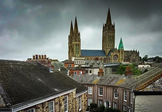
Truro, Cornwall’s only city and its administrative heart, sits at the head of the River Fal, where tidal creeks narrow and the landscape begins to turn inland. It’s a compact, walkable place that works well as a gentle contrast to the coast — cultural rather than scenic, but still closely tied to the waterways that shaped Cornwall’s trade and identity.
What to see and do in Truro
Truro Cathedral – Cornwall’s most striking landmark, completed in 1910 and one of the few UK cathedrals with three spires. Step inside to see the stained glass, carved stonework and vaulted interior.
Suggested time: 45 minutes–1 hour | Entry: Free (donations welcomed)Lemon Street Market – A restored Victorian arcade housing independent shops, galleries, cafés and small restaurants. A good place to browse or pause for coffee.
Victoria Gardens, – A peaceful green space just off the city centre, ideal for a short break or picnic.
Truro City Market – Held regularly in the centre, showcasing local produce, food stalls and Cornish crafts.
Royal Cornwall Museum – Explores Cornwall’s archaeology, art and social history, including mining, maritime trade and regional identity.
Riverside walks – Flat, scenic paths follow the Truro, Kenwyn and Allen rivers, offering a quieter way to explore the city’s edges and estuary setting.
-
Truro, the "capital city" of Cornwall, is located in the scenic River Fal valley, approximately 20 miles (32 km) west of Plymouth. The city's name, Truro, comes from the Cornish term "Tri-veru," which means "three rivers," reflecting its position at the confluence of the Truro, Kenwyn, and Allen rivers. This strategic location has played a key role in the city's development throughout history.
Truro's origins trace back to the Roman era, when it was founded as Treveris in the 1st century AD. Over time, the city was influenced by a variety of cultures, including the Saxons and the Vikings. By the early 13th century, Truro had become an established settlement and was granted a charter by King John in 1201, marking the beginning of its formal status as a town.
During the 16th century, Truro began to flourish as a vital port, especially as Cornwall became known for its tin mining industry. The city played a key role in the export of tin, which was in high demand throughout Europe. This economic boom helped Truro grow and become an important trading hub.
In the 18th and 19th centuries, Truro saw significant expansion, becoming a major center of commerce and industry. As a key port for exporting goods such as tin, copper, and other minerals, the city attracted traders, merchants, and industries, further boosting its economic stature. This era also saw the construction of elegant Georgian and Victorian buildings, many of which still define the architectural character of the city center today.
Truro's Victorian growth was also spurred by the expansion of its rail network in the 19th century, which connected the city to larger cities and boosted both trade and tourism. The impressive Truro Cathedral, built in the late 19th century, is a testament to the city’s growth and ambition during this period. Today, Truro remains an important cultural, commercial, and administrative hub in Cornwall, with a rich history that continues to influence its vibrant present.
-
Truro's historic port and tin mining industry played a crucial role in the city’s development, particularly during the 16th century. Cornwall, known for its rich deposits of tin, became a key location for mining and trade. Truro's location along the River Fal made it an ideal port for the transportation of tin and other minerals, helping it to grow into a prosperous commercial centre. During this time, the city became a vital point for both domestic and international trade, particularly with countries across Europe.
Tin mining in Cornwall was an important industry that fueled the local economy, with the Cornish tin mines being some of the richest in Europe. As the industry grew, towns like Truro became hubs for the exchange of goods, including the export of tin to markets around the world.
In Poldark, the popular television series based on the books by Winston Graham, the depiction of Cornwall’s tin mining heritage is central to the storyline. Although Truro is not a primary location in the series, the Poldark story revolves around the lives of those involved in the Cornish mining industry, and the real-life towns of Charlestown, St. Just, and Penwith are often referenced. The series highlights the hardships and significance of tin mining in Cornwall, with references to how towns like Truro supported the industry and how the mining wealth and struggles shaped the region.
The period portrayed in Poldark reflects Cornwall's industrial past, where mining was central to the economy, and many aspects of Truro’s history—from its role as a port to its involvement in tin production—are mirrored in the show's narrative. The Poldark series helped bring renewed attention to Cornwall’s industrial history, including its tin mining roots, even if Truro itself is not often shown directly on screen.
-
Truro’s location offers easy access to some of Cornwall’s most breathtaking landscapes, making it a perfect base for exploring the natural beauty that the region is renowned for. Situated near the Roseland Peninsula, Truro provides visitors with a gateway to one of Cornwall's most picturesque areas. The Roseland Peninsula is characterised by rolling hills, rugged cliffs, and charming coves, offering a mix of coastal and countryside beauty that makes it a must-see for nature lovers.
The peninsula is known for its stunning beaches, such as Pendower Beach and Towan Beach, where visitors can enjoy the serene coastal environment and take in views of the Atlantic Ocean. In addition to its beaches, the Roseland Peninsula is home to the South West Coast Path, a long-distance trail that winds along dramatic cliffs, offering panoramic views of the coastline. The area’s wildflower-rich meadows, hidden valleys, and peaceful estuaries also contribute to its idyllic charm.
Beyond the Roseland, Truro’s central position makes it a perfect base for accessing a variety of other Cornish natural attractions. To the north, the North Coast offers sweeping beaches like St Agnes and Porthtowan, as well as the wild beauty of Gwithian Towans. To the south, you can easily explore The Lizard Peninsula, home to Kynance Cove, one of Cornwall's most famous beaches, with its turquoise waters and dramatic rock formations.
Truro itself is surrounded by lush countryside, with the Tamar Valley to the east and the Fal River meandering through the city. The nearby Boscawen Park and Victoria Gardens offer green spaces for relaxation and scenic walks, while the Penrose Estate, located just outside the city, provides access to tranquil lakes, woodlands, and open fields.
With its easy access to the Roseland Peninsula and its proximity to both Cornwall's stunning coastal areas and tranquil rural landscapes, Truro serves as an ideal location for anyone looking to immerse themselves in the natural beauty of the region. Whether you're interested in coastal hikes, exploring quiet coves, or simply enjoying the fresh air and scenic views, Truro offers the perfect gateway to Cornwall's incredible outdoor wonders.
-
Truro offers a variety of scenic walks along the riverside paths of the Truro, Kenwyn, and Allen rivers, each providing a unique perspective of the city and its surrounding natural beauty. These riverside trails wind through tranquil landscapes, offering peaceful escapes from the urban environment while showcasing some of Cornwall’s most picturesque countryside.
Starting with the Truro River, the Truro River Walk takes you along the water’s edge, with views of the historic city, its quay, and the estuary. The path meanders through areas of natural beauty, including woodlands and fields, and offers a chance to observe local wildlife, such as birds and waterfowl. Walking along the river, you’ll enjoy ever-changing views of the city’s skyline, the old harbour, and glimpses of traditional Cornish cottages dotted along the riverbank. The walk can also lead to the village of Malpas, which sits at the confluence of the Truro River and Tamar River, providing scenic vistas and a peaceful setting.
The Kenwyn River, which flows through the city, offers a more intimate walk. The Kenwyn River Walk takes you through peaceful woodlands and meadowlands, with the sound of the river creating a serene atmosphere. This walk showcases the green heart of Truro, with the city’s lush countryside providing a backdrop to the bubbling river. As you walk along this path, you may encounter quaint bridges, ancient trees, and the occasional glimpse of local wildlife. The route leads you towards the Kenwyn Valley, where the river’s meandering flow and verdant surroundings offer an immersive experience in nature.
On the opposite side of the city, the Allen River Walk offers a more rural and tranquil path. The Allen River, a smaller tributary, winds through quiet farmland, making it an excellent route for those who want to experience the peace and quiet of Cornwall’s rural countryside. The path takes you along the riverbank, through lush vegetation and traditional Cornish hedgerows. The area is known for its biodiversity, so keep an eye out for local flora and fauna. As the walk progresses, you’ll be treated to views of the surrounding hills and valleys, creating a sense of seclusion and natural beauty.
Each of these riverside walks provides a chance to connect with Cornwall’s natural environment while exploring Truro’s beautiful landscape. Whether you’re looking for a short stroll or a longer, more immersive walk, these paths offer an easy way to enjoy the tranquility of the rivers and surrounding countryside. They also provide opportunities for birdwatching, photography, and simply enjoying the fresh air in one of the most scenic areas of Cornwall. Whether you’re a local resident or a visitor, these walks offer a peaceful way to experience the beauty of Truro’s rivers and the natural wonders of the area.
From Truro to Bodmin (via the Eden Project, optional)
Leaving Truro, the route turns inland through rolling Cornish countryside, following the upper reaches of the Fal before climbing gently towards central Cornwall.
For those wanting a distinctive stop along the way, a short detour leads to the Eden Project, set in a reclaimed clay pit near St Austell. It’s an easy diversion from the main route and works well as a half-day pause, especially if you’re travelling at a slower pace or want a change from coastal scenery.
Continuing on, the road rises towards Bodmin, where estuaries give way to open uplands and the granite landscape of Bodmin Moor comes into view — marking the final shift from river and harbour to Cornwall’s inland heart.
The Eden Project – An Inland Detour into Cornwall’s Living Landscapes
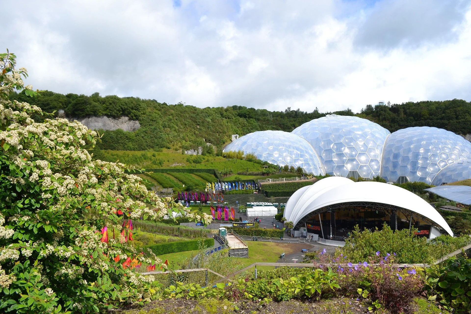
The Eden Project The Eden Project is one of Cornwall’s most distinctive inland stops, created within a reclaimed china clay pit near St Austell. What was once an industrial landscape has been transformed into a vast global garden, exploring the relationship between people, plants and the natural world.
At its heart are the iconic Biomes — enormous covered structures housing contrasting climates. Inside, you can walk through one of the world’s largest indoor rainforests, explore Mediterranean landscapes, and discover plants from across the globe, from arid regions to temperate zones.
Beyond the Biomes, outdoor gardens and trails explore wild and cultivated landscapes, sustainability, and conservation in a way that’s accessible without being didactic. Temporary exhibitions, seasonal installations and family-friendly activities add variety throughout the year.
For those wanting something more active, Eden also offers optional adventure experiences, including a zip wire, aerial assault course and giant swing — though these are very much add-ons rather than the core experience.
How it fits the route:
Eden works best as a half-day detour between Truro and Bodmin, offering a clear contrast to Cornwall’s coastal scenery before the journey continues inland towards Bodmin Moor.
Getting there by road
The Eden Project is located near St Austell in mid-Cornwall. From Truro, allow around 45–50 minutes by car. From Bodmin, the drive is typically 35–40 minutes. The final approach is well signposted from the A390 and A391.
Parking
On-site parking is available and included with entry. The car parks are large but can involve a short walk or shuttle, depending on how busy it is.
From the Eden Project to Bodmin
Leaving the Eden Project, the route turns decisively inland. The lush, carefully managed landscapes around St Austell give way to higher ground and a more elemental feel as the road climbs towards Bodmin Moor.
This short final stretch marks a clear change of mood — away from coastal towns and estuaries, and into Cornwall’s granite heart. Hedgerows thin, views widen, and the sense of scale returns, preparing you for the wilder landscapes around Bodmin and the quieter conclusion of the journey.
By road, the drive from Eden to Bodmin takes around 35–40 minutes, making it an easy final leg after a half-day inland detour.
For travellers finishing the route here, Bodmin works as a natural pause point — well connected, historically rich, and well placed for exploring the moor or beginning the journey home.
Bodmin – Cornwall’s Historic Heart
Set just south-west of Bodmin Moor, Bodmin is one of Cornwall’s oldest towns and was once its administrative centre. The town’s imposing granite buildings reflect its importance during the tin-mining boom of the 18th and 19th centuries, when Bodmin sat at the centre of Cornwall’s legal, civic and industrial life.
Bodmin also played a pivotal role in Cornish history. In 1497, it was the starting point of the Cornish Rebellion, when around 15,000 Cornishmen marched on London in protest against heavy taxation — a defining moment in Cornwall’s identity.
A short walk through the town reveals layers of this past, from medieval churches to austere civic buildings.
What to see and do in Bodmin
Bodmin Jail - One of Cornwall’s most atmospheric landmarks. Built in the 18th century, the former prison is known for its stark architecture, turbulent history and ghost stories. Today it’s a major visitor attraction exploring crime, punishment and social history.
Church of St Petroc - The largest parish church in Cornwall, dating largely from the 15th century. Dedicated to St Petroc — Cornwall’s patron saint — it stands on the site of one of the earliest Christian settlements in the region.
Bodmin Shire Hall (Old County Courthouse) - Once the centre of Cornwall’s judicial system, now a visitor attraction offering insight into law, justice and local governance.
Bodmin Keep, Cornwall's Army Museum - Cornwall’s Army Museum, telling the stories of local regiments and soldiers through a substantial collection of artefacts and exhibitions.
Bodmin works well as a short cultural stop or an overnight base before heading onto the moor.
-
Bodmin is a historic town in Cornwall, England, with a rich heritage that dates back to Roman times. It was originally known as a Roman settlement, with the town's name believed to be derived from the Cornish word "Bodmyn," meaning "house of the monks" due to its association with an early Christian monastery.
In the Middle Ages, Bodmin was an important religious center. It became a thriving market town and gained prominence as a hub for the Cornish tin mining industry. The town also became known for its Bodmin Abbey, which was founded in the 6th century by Saint Petroc, a key figure in Cornish Christianity.
During the 14th century, Bodmin played a notable role in the Cornish Rebellion of 1497. It was one of the major centers of the Cornish uprising, and the Bodmin Jail was later established to imprison criminals.
By the 19th century, Bodmin continued to prosper, particularly with the arrival of the railway, which facilitated further development and connected the town to other parts of Cornwall and beyond. Today, Bodmin maintains its historical charm while being a popular base for exploring the surrounding area, including Bodmin Moor and the Camel Trail.
The town's Bodmin Jail, Bodmin Beacon, and St. Petroc’s Church are just some of the historical landmarks that reflect the town’s rich past.
-
Bodmin Moor is a vast and rugged expanse of moorland located in Cornwall, offering visitors a glimpse into the region's natural beauty, history, and folklore. Known for its dramatic landscape, Bodmin Moor is a popular destination for outdoor enthusiasts, nature lovers, and those interested in Cornwall's rich heritage.
Things to Do and See on Bodmin Moor:
Rough Terrain and Scenic Walks:
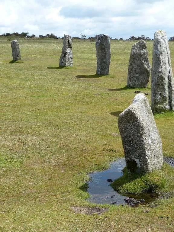
Bodmin Moor is perfect for hiking and walking with its open, expansive moorland and scenic views. There are numerous footpaths and trails, including routes that take you through heather-covered hills, ancient stone circles, and dramatic granite outcrops.
Popular walks include the Bodmin Moor Walking Trail, which takes you through areas like Brown Willy (Cornwall’s highest point) and Roughtor, providing panoramic views of the moorland and beyond.
Historical and Archaeological Sites:
King Arthur’s Hall: An ancient stone circle believed to be linked to the Arthurian legends.
The Hurlers: A prehistoric stone circle located near Minions on the moor, dating back to around 1500 BC. The circle is associated with local legends of cursed figures turned to stone.
Bodmin Jail: A historic prison, now a museum, that was once used to imprison criminals in the 18th and 19th centuries. It’s also reputed to be one of Cornwall’s most haunted sites.
Wildlife and Nature:
Bodmin Moor is a haven for wildlife, including a variety of bird species, wild ponies, and deer. The area is part of the Bodmin Moor Special Area of Conservation, making it a protected natural space. Visitors may also spot rare plants and enjoy the peace and tranquility of the open moorland.
Camel Trail:
The Camel Trail, a well-known cycling and walking route, runs along the River Camel. While the trail itself doesn’t cross Bodmin Moor directly, it passes through parts of the moorland, offering a beautiful view of the area’s countryside and valleys.
Bodmin Moor in Folklore:
Bodmin Moor is steeped in local myths, legends, and tales. The Beast of Bodmin, a creature said to resemble a panther, has been part of the area’s folklore for decades, with sightings occasionally reported. It is thought to be an escaped big cat from a private collection, though some believe it to be a supernatural being.
How to Get to Bodmin Moor:
By Road:
Bodmin Moor is easily accessible from major towns in Cornwall, such as Bodmin, Liskeard, and Camelford, via the A30 and A38 roads. The moor is located a short drive from these towns, making it a great day-trip destination from many areas in Cornwall.By Train:
The nearest train station to Bodmin Moor is Bodmin Parkway, which is about 5 miles from the moor. From there, you can take a bus or drive to the moorland.By Bus:
First Kernow operates bus services that connect towns like Bodmin, Liskeard, and Camelford to the moor. However, public transport options can be limited in some areas, so driving is often the most convenient way to access the moor.
Parking at Bodmin Moor:
There are several parking areas near popular landmarks such as Roughtor, Brown Willy, and Minions.
Minions Car Park: This car park provides access to many of the popular walking trails and stone circles on the moor.
There are also some free parking spots at the start of walking trails in the area, but be aware that some parking areas may be more limited during peak seasons.
Best Time to Visit:
The best time to visit Bodmin Moor is during the spring and summer months when the weather is milder and the moorland is at its most vibrant. However, autumn can also be a beautiful time to explore, with the landscape covered in rich golden hues. Winter can be rugged and cold, but also provides a peaceful atmosphere with fewer visitors. Be prepared for variable weather, and check forecasts before heading out.
Tips for Visiting:
Wear sturdy footwear: The terrain on Bodmin Moor can be uneven and boggy, so appropriate hiking boots are recommended.
Bring a map or GPS: While the area is well signposted, it’s always wise to have a map or GPS for navigation, especially if venturing off the main trails.
Respect nature: Bodmin Moor is a protected site, so it’s essential to stick to marked paths and respect wildlife and heritage sites.
Visiting Bodmin Moor offers a peaceful and immersive experience in one of Cornwall’s most captivating natural areas, filled with history, legend, and remarkable scenery.
-
Bodmin Jail is a historic former prison that dates back to the 18th century. Originally built in 1779, the jail served as a county prison for Cornwall and was known for its imposing granite facade and formidable reputation.
Throughout its history, Bodmin Jail housed a variety of prisoners, including debtors, criminals, and accused witches. The conditions within the prison were harsh, with overcrowding, poor sanitation, and inadequate provisions being common issues. The famous prisoners held were Elizabeth Osbourne, Sarah Polgrean and the Lightfoot Brothers.
One of the most infamous aspects of Bodmin Jail's history is its role as the site of numerous executions. Over the years, a significant number of prisoners were sentenced to death at Bodmin Jail, with hangings taking place within the prison walls. The last execution at Bodmin Jail occurred in 1909, after which the prison continued to operate until its closure in 1927.
Today, Bodmin Jail stands as an attraction, offering visitors the opportunity to explore its eerie corridors and learn about its fascinating and often grim history. The museum features interactive exhibits, historical displays, and guided tours that provide insight into life within the prison and the stories of the individuals who were incarcerated there.
In addition to its historical significance, Bodmin Jail is reputed to be one of Cornwall's most haunted locations, with numerous reports of paranormal activity within its walls. As such, the jail has become a popular destination for ghost hunters and paranormal enthusiasts.
-
The Jamaica Inn, located on the desolate expanse of Bodmin Moor, was built in 1750 as a coaching inn along the turnpike road, Jamaica Inn served as a resting place for travellers journeying across the moor. The inn gained notoriety in the 19th century for its association with smuggling activities, which were rampant along the Cornish coast. Its remote location made it an ideal hub for smugglers to store contraband goods such as brandy, tobacco, and tea, avoiding customs duties and taxes. Despite numerous raids by revenue officers and law enforcement, the smugglers often outmanoeuvred them, thanks to the treacherous terrain and their intimate knowledge of the area.
Pirate Connections
Legend has it that the inn's name, "Jamaica," reflects its ties to piracy, as it was believed to have been frequented by pirates who roamed the Caribbean seas. While there is little concrete evidence to support this claim, the inn's association with smuggling adds to its mysterious allure.
Folklore
The inn's association with smuggling and its remote location have inspired numerous tales of intrigue and mystery. It is said to be haunted by the ghosts of smugglers, revenue officers, and travellers who met untimely ends on Bodmin Moor.
Daphne du Maurier's novel "Jamaica Inn," published in 1936, further popularised the inn and its eerie reputation. The novel, set in the early 19th century, weaves a tale of smuggling, betrayal, and suspense, adding to the inn's folklore.
Today, Jamaica Inn continues to welcome visitors, offering accommodation, dining, and a museum dedicated to its history and folklore. Whether you're drawn by its pirate connections, intrigued by its ghostly tales, or simply seeking to experience the rugged beauty of Bodmin Moor, Jamaica Inn remains an iconic landmark that captures the imagination of all who visit.

Bodmin Moor – Granite, Space and Myth
Rising immediately north-east of the town, Bodmin Moor is one of Cornwall’s designated Areas of Outstanding Natural Beauty. This is a vast, open granite landscape of tors, prehistoric sites, winding lanes and high, windswept plateaus — a sharp contrast to the coast you’ve been following for most of the journey.
The moor feels remote and elemental, shaped by ancient geology and long human history rather than tourism infrastructure. It’s a place for slowing down, walking, and absorbing a very different sense of Cornwall.
Highlights around Bodmin Moor
Jamaica Inn - A legendary coaching inn, long associated with smugglers, ghost stories and Daphne du Maurier’s novel. It makes a classic stopping point on the moor.
Lanhydrock House and Garden - Just south of the moor, this National Trust estate offers a gentler counterpoint: an elegant country house with extensive gardens and woodland walks.
Camel Valley Vineyard - Located near the edge of the moor, producing award-winning English sparkling wines. Tastings and tours add a relaxed, unexpected note to the inland landscape.
Walking & open landscapes - Bodmin Moor is rich in prehistoric remains, stone circles and ancient routes. Even short walks reveal wide skies, silence and long views — ideal if you want a final reset before heading home.
Closing the Fal River & Central Cornwall Corridor
From the sheltered waters of the Fal to the granite uplands around Bodmin, this final section draws the journey inward. After days shaped by headlands, beaches and open horizons, the landscape softens — becoming quieter, greener and more reflective.
Falmouth and Truro offer Cornwall at its most civic and maritime, shaped by trade, defence and rivers rather than surf and exposure. Bodmin and the moor beyond strip things back further still, revealing a deeper, older Cornwall — one defined by stone, weather and long human memory.
It’s a natural slowing point. Distances are short, but the sense of space returns, making this an ideal place to pause, walk, or simply let the journey settle.
The End of the Cornwall Coastal Road Trip
This road trip traces Cornwall not as a single coastline, but as a series of connected landscapes — each with its own rhythm.
The Atlantic Way delivers scale, surf and exposure, using the A39 as a spine and detours to reach the places that define the north coast.
The Penwith & West Cornwall Loop slows the pace, circling Cornwall’s most elemental peninsula, where walking, light and time matter as much as distance.
The Fal River & Central Cornwall Corridor brings the journey inland, trading drama for depth, and coast for context.
Taken together, the route is less about ticking landmarks and more about understanding how Cornwall changes — mile by mile, coast by coast, inland and back again.
You don’t need to rush it. Each section works on its own, and many travellers will leave with unfinished threads — villages not visited, paths not walked, detours saved for another time. That’s part of the appeal.
Cornwall rewards return journeys.
Whether this is where you turn for home, or simply where one chapter closes before another begins, this is a fitting place to stop — grounded, spacious, and quietly complete.
Continuing Your Journey — Now or Another Time
If this road trip has left you wanting to explore more of Britain, Cornwall connects naturally with several other journeys — whether you’re travelling on from here, heading home by a different route, or planning a future return.
On the way east or north-east
If you’re leaving Cornwall inland, our Stonehenge & Ancient Wessex route is a natural continuation covers big-hitters in Wiltshire, exploring prehistoric landscapes, cathedral cities and downland scenery — from Stonehenge and Avebury. The Mendips and North East Somerset covers Cheddar Gorge and the limestone hills beyond Bath.
Through central southern England
For travellers drawn to classic towns, countryside and slower-paced exploration, the Cotswolds offers a very different rhythm. Market towns, rolling valleys and historic houses provide a gentler counterpoint to Cornwall’s coast, working well as either a short break or a longer, layered journey.
Approaching from the east or south-east
If your journey into Cornwall began from London or the Channel coast, the Sussex Heritage Coast pairs naturally with this route. Covering Seven Sisters, historic ports and 1066 Country, it shares Cornwall’s sense of layered history — but with chalk cliffs, open downland and a very different coastal character.
Across England, Wales and Scotland, our road trips are designed in the same way as this one — structured, flexible, and built around how people actually travel rather than rigid start-to-finish routes.
Whether you link journeys together, travel them separately, or return later to explore a different region, each route stands on its own — while quietly connecting to the next.
Cornwall may be the end of this road trip, but it doesn’t have to be the end of the journey.
Classic Cornwall Coast Last updated: 5 February 2026
Some links may earn Uncover Britain a small commission at no extra cost to you. This helps support the ongoing creation, review and presentation of our road trip guides.
Route information and listings are provided for general guidance only. Always use your preferred navigation system and check official websites to confirm suitability, opening times and the latest details before travelling.
Our guides are reviewed regularly and supported by a mix of editorial research and digital tools to help keep content clear and up to date. If you spot anything that needs updating, we’re always glad to hear from you.