


42 miles (68 km) with a drive time of around 1 hour and 50 mins.
Customisable and Live Navigation via Google Maps –
click here:
Or use the link to jump to the destinations in the guide below
Sennen Cove →
Land’s End →
Porthcurno →
Penzance →
St. Michael’s Mount →
Lizard Peninsula
The Penwith & West Cornwall Loop
From Sennen Cove to the Lizard Peninsula
The Penwith & West Cornwall Loop explores Cornwall at its most elemental — granite headlands, tidal islands and exposed Atlantic cliffs — before turning south around Mount’s Bay and into the warmer, greener landscapes of the Lizard Peninsula.
Beginning near Sennen Cove and Land’s End, the route traces the far western edge of Britain, passing Porthcurno, Penzance and St Michael’s Mount along the sheltered arc of Mount’s Bay.
If you’re exploring west Cornwall on its own, this section naturally works as a loop, returning north through the interior of the peninsula or along the coast. If you’re continuing the wider Cornwall Coastal Road Trip, the route instead flows south towards Falmouth, where the landscape and pace shift again in the Fal River & Central Cornwall Corridor.
Unlike the Atlantic Way, this section is less about a single touring road and more about circling a distinctive landscape. Distances are short, but progress is slow, shaped by coastal walks, viewpoints and time spent off the road — making this one of the most immersive sections of the journey.
How long to allow for the Penwith & West Cornwall Loop
The Penwith & West Cornwall Loop, from Sennen Cove around Land’s End, through Mount’s Bay and on towards the Lizard Peninsula, is compact in distance but slow by nature. Roads are narrow, viewpoints frequent, and many of the highlights sit just off the road.
While the driving itself is short, this is a section where time is shaped by walking, tides and stopping often.
At a glance
Driving time (without stops): around 3–4 hours
Recommended time: 2–4 days
-
2 days: highlights-focused
This works if you want to experience the drama of west Cornwall without lingering too long in each place.
Day 1
Sennen Cove and the Land’s End headlands
Porthcurno and the Minack Theatre area
Evening in or around Penzance
Day 2
St Michael’s Mount and Mount’s Bay
Southward drive towards the Lizard Peninsula
Short coastal walks or beach time on the Lizard
Expect busy days, limited longer walks, and a focus on Cornwall’s most iconic landmarks.
3 days: balanced and immersive
This is the ideal pace for most travellers and allows the landscape to breathe.
Day 1
Sennen Cove, Land’s End and coastal walking
Porthcurno and cliff-top viewpoints
Day 2
Mount’s Bay: St Michael’s Mount, Penzance, and surrounding coastline
Time for galleries, harbour walks or boat trips
Day 3
Explore the Lizard Peninsula more fully, with time for beaches, short hikes and quieter coves
This pace allows flexibility around tides, weather and crowds, and avoids rushing Cornwall’s most dramatic scenery.
4 days or more: slow travel
With extra time, this section becomes one of the most rewarding parts of the whole journey.
Use additional days to:
Walk longer sections of the South West Coast Path
Spend unhurried time on the Lizard Peninsula
Base yourself in one place and explore on foot rather than driving
At this pace, the Penwith section feels less like a route and more like settling into a landscape.
Loop or onward journey
If you’re travelling west Cornwall as a standalone trip, this section naturally works as a loop, returning north through the interior of the peninsula. If you’re continuing the full Cornwall Coastal Road Trip, allow an extra half day to transition south towards Falmouth, where the journey shifts into the calmer rhythm of the Fal River & Central Cornwall Corridor.
From St Ives to Sennen Cove
Leaving St Ives, the route turns south and inland across west Cornwall, crossing the spine of the peninsula rather than clinging to the coast. This short drive marks a clear shift in mood: the softer beaches and artistic atmosphere of St Ives give way to open moorland, stone-walled fields and an increasing sense of exposure as you approach the far western edge of Britain.
By road: around 15 miles / 35–45 minutes via local roads and the A30
Character: rolling interior landscapes followed by a sudden return to the Atlantic
As you descend towards Sennen Cove, the land opens out again and the full force of the Atlantic reasserts itself — wider skies, stronger winds and one of the most dramatic beach settings in west Cornwall.
Sennen Cove – Atlantic Sands at England’s Edge

Sennen Cove sits just a mile from Land’s End and feels every inch like the edge of the country. Sheltered slightly by the granite bulk of the headland, the village wraps around a small harbour and lifeboat station, backed by one of the finest sandy beaches in west Cornwall.
This is a place shaped by the sea: powerful surf, working rescue crews and a long tradition of fishing, folklore and Atlantic weather.
What to see and do in Sennen Cove
Sennen Beach & Surfing – The wide, golden sands face directly into the Atlantic and are among the most reliable surf beaches in Cornwall. The Sennen Surfing Centre, one of the longest-running surf schools in the UK, operates directly on the beach.
RNLI Sennen Cove Lifeboat Station – One of the most important lifeboat stations in Cornwall, protecting a busy stretch of shipping lanes around Land’s End. The station is operated by volunteer crews and offers insight into the lifesaving work of the RNLI. Open days and guided visits are sometimes available.
The Harbour & Old Success Inn – A compact harbour with fishing boats, slipways and coastal views. The Old Success Inn sits just above the beach and is a classic stop for food or a drink overlooking the sand.
Roundhouse Capstan Gallery – A small but characterful gallery built around an original 18th-century capstan, now showcasing local art and crafts.
St Sennen Church – A simple medieval church set slightly inland, with evidence of worship here dating back to at least the 15th century.
-
Getting there by road
Sennen Cove is accessed via local roads from the A30, signposted from Land’s End and Penzance.
Parking
Pay-and-display car parks near the beach and harbour
Spaces are limited in summer — arrive early on busy days
Facilities
Small shops, cafés and a pub
Seasonal surf hire and lessons
Public toilets near the beach
Visiting tips
Best visited early morning or late afternoon to avoid crowds
Check surf and tide conditions if swimming
Highly exposed — expect wind even on sunny days
-
The area of Sennen is steeped in folklore, with tales of giants, faeries, and the mysterious Lost Land of Lyonesse captivating the imagination. One of the most intriguing legends is that of Lyonesse, a mythical land steeped in Arthurian lore, said to be submerged beneath the waters surrounding the Isles of Scilly. According to legend, Lyonesse was the homeland of Tristan, a central figure in the romantic saga of Tristan and Iseult. This Celtic legend thought to be influenced by the tales of Lancelot and Guinevere, adds to the mystique of the region and inspires wonder and fascination among those who explore the stories of Sennen.
Legend speaks of the Sennen Whopper, a mystical spirit with the ability to foretell storms, preventing fishermen from venturing out to sea when danger loomed. However, one fateful night, two fishermen defied the Whopper's warning, embarking on a perilous journey against the tide through the mist. Tragically, they never returned, and neither did the enigmatic Whopper, leaving behind a tale shrouded in mystery and maritime lore.
South West Coast Path at Sennen Cove
The South West Coast Path passes directly through Sennen Cove, offering some of the most dramatic walking of the entire route.
Walk north towards Cape Cornwall for wide Atlantic views and quieter headlands
Walk south towards Land’s End for exposed cliffs, seabirds and powerful seascapes
These paths are rugged and exposed, with uneven ground and strong winds — sturdy footwear and weather layers are essential.
From Sennen Cove to Land’s End
Leaving Sennen Cove, the road hugs the far western edge of Cornwall, skirting low granite headlands and open farmland before narrowing as it approaches Land’s End. The drive is short but atmospheric, with a growing sense that you are travelling towards a geographical threshold rather than simply another village.
By road: approx. 1.5 miles / 5 minutes
On foot: around 1 hour via the South West Coast Path, with exposed cliffs and Atlantic views
Many travellers choose to walk at least part of this stretch, as it captures the raw, elemental character of Penwith better than driving alone.
Land’s End - Britain’s Atlantic edge
Land’s End sits at the westernmost tip of mainland England and has long been regarded as a symbolic edge of the country. While the site includes visitor facilities, it is the coastline itself — wind-carved cliffs, offshore rocks and wide Atlantic horizons — that gives the place its power.
This is not a place to rush. Even a short wander away from the central area reveals quieter paths and far-reaching views reminding you just how exposed this corner of Britain really is.
What to see and do at Land’s End
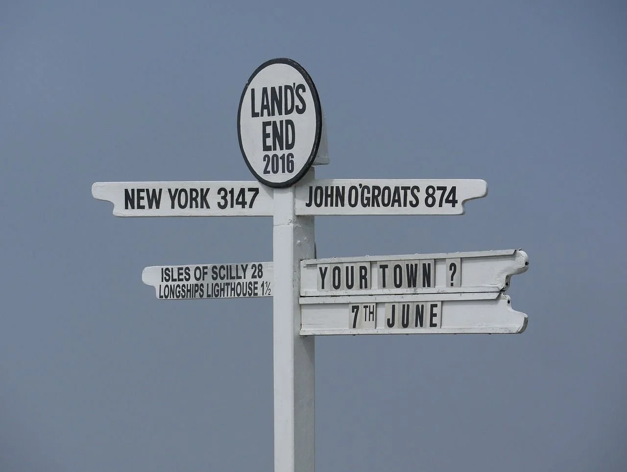
Land's End signpost, – The famous signpost marking distances to John o’ Groats and destinations around the world is a classic photo stop. It’s undeniably touristy, but it’s also part of the tradition of visiting Land’s End.
Explore the First and Last House, a visitor centre offering shops, cafes, and exhibitions showcasing the history and culture of the area.
Clifftop walks – Step away from the central complex and follow the coastal paths in either direction for dramatic scenery, seabirds and uninterrupted Atlantic views.
Land's End Heritage Trail - Offers panoramic views of the Atlantic Ocean and rugged cliffs.
Enys Dodnan Arch & The Armed Knight – These striking natural rock formations lie just offshore and along the cliffs, sculpted by centuries of wave action. They’re best appreciated from the coastal paths, especially in good light or rough seas.
Sunset over the Atlantic – On a clear evening, Land’s End is one of the most memorable sunset spots in Cornwall, with the sun sinking directly into the ocean.
Wildlife spotting – Seals are often seen below the cliffs, and seabirds nest along the rock faces. Offshore, dolphins and basking sharks are occasionally spotted in season.
-
Getting there by road
Land’s End is well signposted from Penzance and Sennen via local roads.
Parking
Large pay-and-display car park on site
Charges apply year-round
Quieter early morning and late afternoon
Facilities
Visitor centre with cafés and shops
Toilets available
Fully accessible main viewing areas
Visiting tips
Walk beyond the main complex for the best experience
Expect strong winds — even on sunny days
Combine with a coastal walk rather than a brief stop
Brief history
Land’s End has been inhabited since prehistoric times, with evidence of Mesolithic activity in the surrounding landscape. For centuries it was regarded as the edge of the known world, a place wrapped in myth and maritime danger.
Its position on busy shipping routes led to countless shipwrecks and tales of piracy, while the Victorian era saw Land’s End emerge as a destination for travellers drawn by its dramatic setting and symbolic status.
-
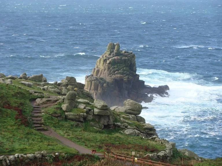
Land’s End is renowned for its dramatic granite formations, shaped by relentless Atlantic weather over millennia.
The Armed Knight – A tall granite stack rising from the sea, resembling a sentinel guarding the coast. Particularly striking when silhouetted against the horizon.
Enys Dodnan Arch – A natural sea arch carved by wave action, framing the Atlantic beyond and one of the most recognisable features along this coast.
The Longships Rocks – A jagged offshore reef supporting Longships Lighthouse, vital for navigation in these hazardous waters.
Dr Syntax’s Head – A playful rock formation said to resemble a human profile when viewed from the right angle.
These formations also support rich wildlife, including nesting seabirds and seals resting on the rocks below.
South West Coast Path at Land’s End
The South West Coast Path passes directly through Land’s End, and walking even a short stretch in either direction transforms the experience from a brief stop into something far more immersive.
Walking north towards Sennen Cove
This is one of the most dramatic short walks in Cornwall. The path follows exposed granite cliffs with uninterrupted Atlantic views, passing sea stacks and blowholes shaped by constant wave action. It’s rugged, windswept and feels unmistakably like the edge of the country.
Character: wild, exposed, elemental
Highlights: Armed Knight rock, Enys Dodnan Arch, seabirds and crashing surf
Effort: moderate, uneven ground and strong winds
Walking south towards Porthcurno
Heading south, the path begins to soften as the coastline curves into Mount’s Bay. Cliffs remain dramatic, but the sense of exposure gradually eases, offering a clear contrast to the raw Atlantic edge you’ve just left behind.
Character: transitional, scenic, slightly more sheltered
Highlights: wide coastal views, quieter paths, changing light
Practical walking tips
Even short walks here feel committing — allow at least 30–60 minutes
Sturdy footwear is essential
Wind can be strong in all seasons
Walking from Sennen Cove to Land’s End is often more rewarding than driving
Land’s End marks the turning point of the Penwith journey. From here, the route begins to curve eastwards along the more sheltered arc of Mount’s Bay, towards Porthcurno, Penzance and St Michael’s Mount — where the mood shifts again from raw exposure to coastal intimacy.
From Land’s End to Porthcurno
Leaving Land’s End, the road turns south and begins to drop into a greener, more sheltered landscape as the coast curves into Mount’s Bay. The shift is immediate: exposed granite headlands soften into deep valleys, streams, and beaches enclosed by steep cliffs.
By road: approx. 7 miles / 15–20 minutes via local coastal roads
On foot: a longer but spectacular South West Coast Path walk, best broken into sections
This short journey marks a clear change in character — from raw Atlantic exposure to one of Cornwall’s most intimate and dramatic beach settings.
Porthcurno - Cliff-ringed beaches and global connections
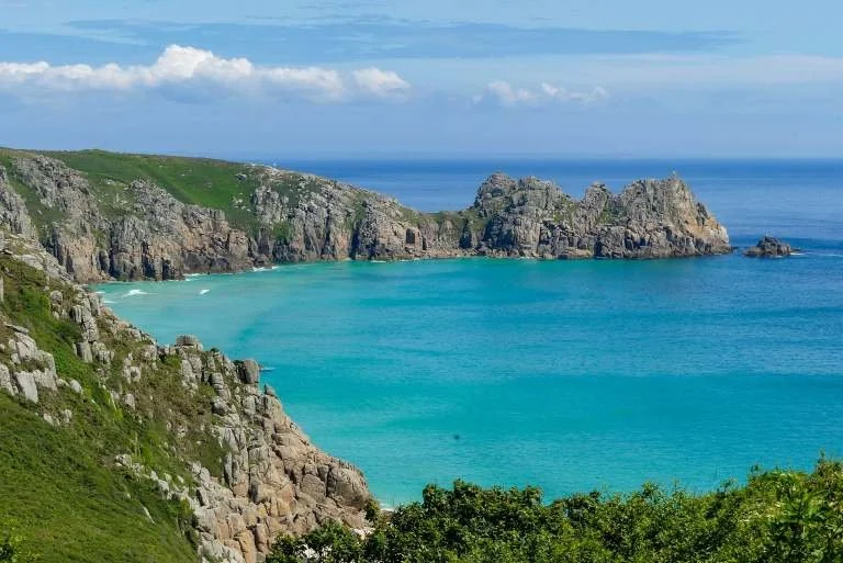
Porthcurno is a small coastal valley opening onto one of Cornwall’s most striking beaches. Sheltered by towering cliffs and fed by a freshwater stream, it feels worlds away from the Atlantic edge you’ve just left — calmer, greener, and intensely scenic.
Despite its quiet scale, Porthcurno has played an outsized role in global history.
What to see and do in Porthcurno
Porthcurno Beach – A wide sweep of fine, pale sand backed by steep cliffs, with clear water and a stream running down one side, ideal for paddling. Sheltered conditions make it popular for swimming and snorkelling, though tides and waves should always be respected.
Minack Theatre – Carved directly into the granite cliffside above the beach, the Minack Theatre is one of Cornwall’s most extraordinary sights. Even outside performance times, the setting alone is worth the visit. (See below for more information)
PK Porthcurno – Museum of Global Communications – Once the landing point for international telegraph cables, Porthcurno connected Britain to the wider world. The museum tells this remarkable story through interactive exhibits, historic cable huts and wartime bunkers.
Logan Rock (nearby) – A dramatic coastal viewpoint and geological curiosity, reached via clifftop paths, offering expansive views across Mount’s Bay.
-
Getting there by road
Porthcurno is reached via narrow local roads from Penzance and Land’s End. Access drops steeply into the valley.
Parking
Pay-and-display car park above the beach
Spaces are limited and fill quickly in summer
Steep walk down to the beach — allow time and energy for the return climb
Public transport
Bus: seasonal services link Penzance, Land’s End and Porthcurno
Train: nearest station is Penzance, with onward bus or taxi
Visiting tips
Arrive early in peak season
Check tide times — the beach changes dramatically
Combine beach time with Minack Theatre or coastal walking
South West Coast Path
The South West Coast Path passes directly above Porthcurno, linking Land’s End with Mount’s Bay.
From Land’s End: exposed cliffs gradually giving way to more sheltered coves
Towards Penzance: dramatic but gentler walking with wide bay views
This is one of the most rewarding stretches of the path, combining height, colour and constant changes in perspective.
Visiting the Minack Theatre
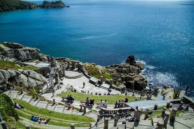
Perched high above Porthcurno Beach, the Minack Theatre is one of the most extraordinary performance spaces in the world. Carved directly into the granite cliffs, it combines theatre, landscape and Atlantic drama in a way that feels inseparable from its setting.
A brief history
The Minack Theatre was the vision of Rowena Cade who began carving the theatre into the cliff in the early 1930s with little more than hand tools and determination. The first performance took place in 1932, and over time the site evolved into a fully functioning open-air amphitheatre, built stone by stone into the rock.
Today, it remains a working theatre while also welcoming visitors outside performance times.
What you can do at the Minack
Visit during the day – Even without a ticket, daytime visits allow you to explore the terraces, gardens and viewpoints. The scale of the theatre and the views across Porthcurno are often just as impressive as during a performance.
Attend a performance – The Minack hosts a varied programme, including Shakespeare, drama, musicals and concerts. Performances are weather-dependent and feel completely different from conventional indoor theatre.
Explore the exhibition – An on-site exhibition explains the theatre’s construction, Rowena Cade’s life and the site’s cultural significance, with photographs and original artefacts.
-
Tickets and access
Daytime visits require a timed entry ticket
Performance tickets should be booked well in advance in peak season
Seating is stone — cushions or layers are strongly recommended
Getting there
Accessed via steep, narrow roads from Porthcurno
Follow signs specifically for the Minack Theatre
Parking
Dedicated car park above the theatre
Short but steep walk down to the entrance
What to bring
Warm layers, even in summer
Sun protection — the seating is exposed
Sensible footwear for uneven stone steps
Good to know
Performances continue in most weather conditions
Photography is usually restricted during performances
Allow extra time to explore the viewpoints and gardens

From Porthcurno to Penzance
Leaving Porthcurno, the route continues east along the south coast, where steep valleys gradually open out and the Atlantic edge begins to soften. The road follows the curve of Mount’s Bay, trading exposed cliffs for gentler coastal scenery, wider horizons and a growing sense of settlement.
By road: around 8 miles / 20–25 minutes
Character: sheltered coastline, working harbours and calmer seas
Between Porthcurno and Penzance, the road passes close to small harbour villages like Mousehole and Newlyn. These make easy, optional detours if you want a slower afternoon or an unplanned supper by the water — but they’re just as easily left for another visit.
As you approach Penzance, the journey shifts again. Fishing coves and beaches give way to a larger harbour town, where maritime history, promenades and cultural life come together — setting up a natural pause point before exploring St Michael’s Mount and continuing south towards the Lizard.
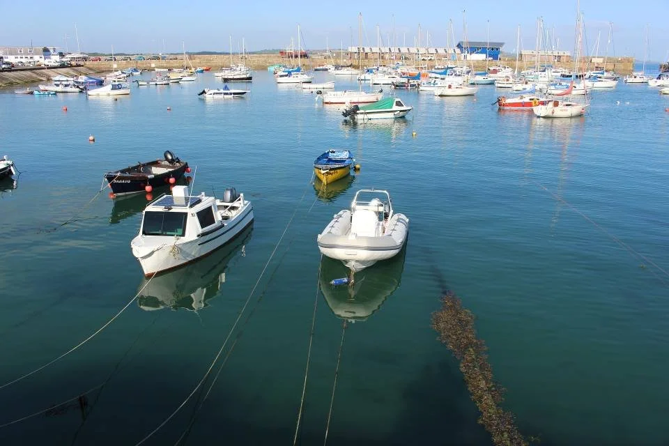
Penzance - Maritime heritage, culture and the gateway to Mount’s Bay
Penzance is a lively coastal town set along the sheltered curve of Mount’s Bay, where Cornwall’s Atlantic drama softens into promenades, harbours and historic streets. It works well as a base rather than a brief stop — a place to pause, walk, eat well and explore on foot before continuing to St Michael’s Mount and the Lizard.
What to see and do in Penzance
Harbour & seafront – The working harbour is still central to daily life. Boat trips, sea safaris and fishing excursions depart from here, while the promenade offers open views across the bay towards St Michael’s Mount.
Promenade walks – A long, level seafront connects Wherrytown, the harbour and Long Rock, ideal for gentle walking with constant sea views.
Chapel Street – Penzance’s most historic street, lined with 17th- and 18th-century buildings, independent shops and galleries. Highlights include:
Egyptian House – a rare example of Egyptian Revival architectur
Admiral Benbow Inn – a characterful, nautical pub
Union Hotel – central to the town’s naval history
Art & culture – Penzance has a strong artistic identity, shaped by its proximity to Newlyn and west Cornwall’s long artistic tradition. Key stops include Penlee House Gallery and Museum which explores Cornish art and social history, alongside contemporary galleries in town. The Exchange Gallery and the Newlyn Art Gallery, both of which feature contemporary art exhibitions.
Gardens & green spaces – Morrab Garden offers a surprisingly lush retreat, filled with Mediterranean and sub-tropical planting.
Beaches – Wherrytown Beach and Long Rock Beach provide calm waters and long, open sands, well suited to swimming and relaxed beach time.
-
Getting there by road
Penzance sits at the western end of the A30 and is well signposted. It’s a natural hub for exploring Mount’s Bay and west Cornwall.
Parking
Several pay-and-display car parks near the seafront and town centre
On-street parking is limited in peak season
By train
Penzance is the terminus of the mainline railway, with direct services from London and across the south west — making it one of Cornwall’s easiest towns to reach without a car.
Getting around
The town is compact and best explored on foot. Local buses connect Penzance with Marazion, Mousehole, Newlyn and Land’s End.
Brief overview & history
Penzance developed as a fishing port and trading town, growing in importance through maritime commerce and coastal defence. Its position on Mount’s Bay made it a natural point of exchange between Cornwall and the wider world.
In the 18th and 19th centuries, Penzance also became a cultural centre, attracting artists, writers and travellers — a legacy that continues today.
-
Although Horatio Nelson never visited Penzance, the town holds a unique place in British naval history.
The news of Nelson’s victory — and death — at the Battle of Trafalgar (1805) was first announced in Penzance at the Union Hotel on Chapel Street. The hotel’s ballroom later hosted Cornwall’s first recorded performance of Rule Britannia, marking the moment with both celebration and mourning.
This moment cemented Penzance’s place in the national story, and the Union Hotel remains one of the town’s most historically resonant landmarks.
South West Coast Path at Penzance
The South West Coast Path passes directly through Penzance, following the promenade and coastline around Mount’s Bay. This is one of the gentler stretches of the path, with level walking, wide views across the bay and frequent places to stop for food or rest. Many visitors use this section to walk between Penzance and Marazion, combining coastal scenery with easy access to St Michael’s Mount.
From Penzance to St Michael’s Mount
Leaving Penzance, the route follows the coast east around Mount’s Bay to Marazion, the mainland crossing point for St Michael’s Mount. Unlike most stops on this journey, visiting the Mount is shaped by the tides, making timing part of the experience.
By road: approx. 3 miles / 10 minutes to Marazion
By train or bus: frequent local services connect Penzance and Marazion
At low tide, a historic stone causeway is revealed, allowing you to walk across to the island — a memorable approach that emphasises the Mount’s tidal setting. At high tide, access is by small boat from Marazion harbour, offering a different but equally atmospheric arrival.
Whichever way you cross, the Mount rises dramatically from the bay, marking a clear shift from the urban energy of Penzance to one of Cornwall’s most iconic and carefully preserved landmarks.
St Michael’s Mount - A tidal island of legend, history and gardens

What to see and do
The Castle & Historic Rooms – Enter an ancient fortress that is also a lived-in family home. Interiors reveal layers of medieval, Tudor and later history, with commanding views across the bay.
Terraced Gardens – Sheltered stone terraces support subtropical planting rarely seen at this latitude. The gardens are a highlight in their own right, especially in spring and early summer.
The Causeway Walk – Crossing on foot at low tide is a defining experience: a slow, deliberate approach that emphasises the Mount’s island character.
The Harbour Village – A small cluster of historic buildings around the harbour includes shops, cafés and the sense of a working island community.
St Michael’s Mount rises dramatically from Mount’s Bay, linked to the mainland town of Marazion by a man-made stone causeway that appears and disappears with the tide. For over 1,400 years, the Mount has been a place of religious devotion, defence and family life — and today it remains one of Cornwall’s most evocative landmarks.
A chapel dedicated to St Michael stood here by the 5th century. In the 12th century, a Benedictine priory was founded, later dissolved in the 16th century. The island has been home to the St Aubyn family since the 17th century, who built the present castle and continue to live here today, alongside stewardship by the National Trust.
-
Crossing to the Mount
Low tide: walk across the stone causeway from Marazion
High tide: small boats operate from Marazion harbour
Tide times vary daily — check in advance and plan your arrival accordingly.
Getting there
By road: short drive from Penzance to Marazion
By train or bus: frequent local services connect Penzance and Marazion
On foot: an easy coastal walk from Penzance along the promenade and coast path
Tickets & access
Entry to the island village is usually free
Castle and gardens require a timed ticket
Numbers are limited — booking ahead is strongly recommended in peak season
Visiting tips
Allow 2–3 hours for a relaxed visit
Wear comfortable shoes — cobbles, steps and slopes
Arrive early or late in the day for a quieter experience
Why St Michael’s Mount matters on this journey
After the exposed cliffs of Land’s End and the intimacy of Porthcurno, St Michael’s Mount introduces a different kind of drama — tidal, ceremonial and deeply historic. It’s a moment where the journey pauses again, shaped by water and time rather than distance, before the route turns south towards the wider landscapes of the Lizard Peninsula.
From St Michael’s Mount to the Lizard Peninsula
Leaving Mount’s Bay, the route turns decisively south, moving away from tidal islands and promenades into a broader, more rural landscape. The road climbs gently inland before descending again towards the Lizard, and with it the mood shifts once more — from ceremonial and historic to open, windswept and elemental.
By road: around 25–35 miles depending on route and first stop on the peninsula
Character: quieter roads, heathland, open skies and long coastal edges
This transition is less about hugging the shoreline and more about crossing into a different peninsula altogether. Fields replace harbours, traffic thins, and the sense of being on a distinct landmass becomes clear.
By the time you reach the Lizard Peninsula, Cornwall feels different again: greener in places, wilder in others, and edged by cliffs that face both the Atlantic and the English Channel. It’s the final major landscape shift of the journey — and one that rewards slowing down.
From here, exploration becomes looser and more immersive, shaped by short drives, coastal walks and standout coves such as Mullion and Kynance, before the route eventually curves back north towards Falmouth and the Fal River Corridor.
Lizard Peninsula - Cliff edges, rare landscapes and the southernmost edge of Britain
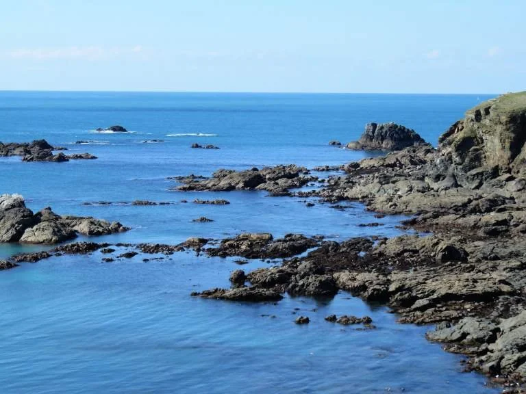
The Lizard Peninsula forms the southernmost part of mainland Britain, stretching south from Mount’s Bay to Lizard Point. Distinct from the rest of Cornwall in both geology and feel, it is a place of wide skies, heathland, exposed cliffs and secluded coves — and a fitting final landscape in this coastal journey.
Designated a Natural Character Area, the peninsula is defined by its serpentine rock, rare wildlife and long, uninterrupted stretches of coast. Exploration here is best done slowly, with short drives linked by walking and time spent off the road.
What to see and do on the Lizard Peninsula
Lizard Point & Lighthouse - At the southernmost tip of Britain, Lizard Lighthouse stands above busy shipping lanes. Clifftop paths here offer expansive views across both the Atlantic Ocean and the English Channel, with frequent wildlife sightings offshore.
Kynance Cove - One of Cornwall’s most recognisable beaches, Kynance Cove lies just north of Lizard Point. Reached via a steep coastal path, it’s a tidal cove famed for turquoise water, pale sand and dramatic rock stacks. Visit at low tide for the fullest experience and allow time for the climb back up.
Mullion Cove - Mullion Cove is one of the peninsula’s most photographed spots — a small, stone-built harbour tucked beneath steep cliffs on the west coast. It works best as a short stop or coastal walk rather than a long visit, and pairs well with nearby clifftop paths.
Coastal walking & wildlife - Large stretches of the peninsula are protected by the National Trust, with excellent walking along the South West Coast Path. Seals are regularly seen below the cliffs, and dolphins are occasionally spotted offshore. The area is also home to rare plants, including the Lizard orchid.
-
Getting there by road
The peninsula is reached via local roads south of Helston. Roads are generally quiet but narrow, and progress is slower than distances suggest.
By train
The nearest mainline stations are Penzance and Camborne, with onward bus connections.
Parking
Small car parks near Lizard Point, Kynance Cove and Mullion Cove
Many are pay-and-display and fill quickly in summer
Some involve steep walks to the coast
Visiting tips
Allow at least a full day, ideally longer
Check tide times for Kynance Cove
Expect wind — even in settled weather
Distances are short but walking is often steep
South West Coast Path — the Lizard
The South West Coast Path along the on the Lizard Peninsula, becomes immersive again, threading together coves like Kynance and Mullion, with quieter stretches where wildlife sightings are common and the sense of being on a distinct peninsula is unmistakable.
You don’t need to commit to long-distance hiking to enjoy it. Many of the most rewarding sections work as short, out-and-back walks or point-to-point strolls, easily combined with driving — and they add depth, scale and perspective to this part of the journey before the route turns inland towards Falmouth.
Closing the Penwith & West Cornwall Loop
From the wide Atlantic sands of Sennen Cove to the tidal drama of St Michael’s Mount and the exposed cliffs of the Lizard Peninsula, this section of the journey explores Cornwall at its most elemental. Progress here is measured less in miles than in moments — coastal walks, shifting light, sheltered coves and places shaped by wind, sea and deep history.
Unlike the Atlantic Way, this loop rewards slowing down. Short distances hide steep paths, narrow lanes and viewpoints that invite lingering. It’s a section defined by immersion rather than momentum, where the landscape changes subtly from stop to stop but always remains close to the sea.
By the time you leave the Lizard, the tone begins to soften again.
Continuing to the Fal River & Central Cornwall Corridor
The next chapter turns north towards Falmouth, where Cornwall’s character shifts once more — from exposed headlands to sheltered waters, deep harbours and a stronger maritime rhythm. Here, estuaries replace cliffs, sailing boats replace surf, and the pace becomes calmer and more reflective.
It’s a natural final movement in the journey, closing the coastal loop through the Fal River & Central Cornwall Corridor.
Classic Cornwall Coast Last updated: 4 February 2026
Some links may earn Uncover Britain a small commission at no extra cost to you. This helps support the ongoing creation, review and presentation of our road trip guides.
Route information and listings are provided for general guidance only. Always use your preferred navigation system and check official websites to confirm suitability, opening times and the latest details before travelling.
Our guides are reviewed regularly and supported by a mix of editorial research and digital tools to help keep content clear and up to date. If you spot anything that needs updating, we’re always glad to hear from you.