

93 miles (149 km) with a drive time of around 2 hours and 10 mins.
The Atlantic Highway (A39): England’s Atlantic Coast Route
The Atlantic Highway is the name given to the A39 corridor running from Barnstaple in North Devon to the A30 junction near Newquay, forming the main touring spine along the north coast of Devon and Cornwall. This stretch of road is approximately 70 miles long and is widely regarded as one of the most scenic long-distance routes in southern England.
Despite its name, the Atlantic Highway does not hug the coastline throughout. Instead, it winds through rolling farmland, wooded valleys and traditional market towns, with regular spurs and short detours leading to the coast. These side routes reveal the dramatic landscapes travellers associate with the north Cornish coast — deep-cut harbours, high cliffs, exposed headlands and long Atlantic-facing beaches.
In Cornwall, the Atlantic Highway serves as the backbone for exploring places such as Bude, Camelford and Wadebridge, from which some of the county’s most iconic coastal locations are reached. Rather than a single continuous coastal drive, the Atlantic Highway is best understood as a touring corridor — a practical, scenic route that links together Cornwall’s north coast highlights. It rewards a slower pace, with time to leave the main road, explore the coast, and return to the A39 to continue the journey.
Within this road trip, the Atlantic Highway forms the opening chapter, setting the tone for Cornwall’s wilder Atlantic edge before the route continues into West Cornwall and the calmer landscapes of the Fal River and central Cornwall.
How this guide uses the Atlantic Highway
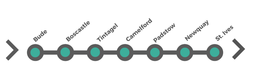
In this guide, the Atlantic Highway (A39) is the main touring spine along Cornwall’s north coast, with short detours to Boscastle and Tintagel, and onward to Padstow on the Camel Estuary. The route then continues west to St Ives, extending the journey beyond the A39 itself. Together, these stops reflect how the Atlantic Highway is most often experienced in practice — using the main road to link Cornwall’s most iconic north-coast destinations rather than following it end to end.
How long to allow for the Atlantic Way
The Atlantic Way, from Bude to St Ives (via Boscastle, Tintagel, Padstow and Newquay), works best when it’s treated as a journey rather than a drive. While the total driving distance is manageable, the real value lies in the detours, coastal walks and time spent off the main road.
At a glance
Driving time (without stops): around 4.5–5 hours
Recommended time: 2–4 days, depending on pace
-
2 days: highlights-focused
This suits travellers short on time who want to experience the character of the north coast without lingering too long in each place.
Day 1: Bude → Boscastle → Tintagel → Camelford
Day 2: Padstow → Newquay → St Ives
Expect fuller days, limited walking, and a focus on the most recognisable landmarks.
3 days: balanced and unhurried
This is the sweet spot for most travellers and works particularly well if you enjoy mixing short walks with driving.
Time for harbour exploration in Boscastle
Space for Tintagel and an inland stop such as Delabole
A relaxed estuary day around Padstow
Coastal time before and after Newquay
Driving days stay comfortable, and there’s room to adapt plans around weather and tides.
4 days or more: slow travel
If you have extra time, the Atlantic Way rewards slowing down.
Use additional days to:
Walk longer sections of the South West Coast Path
Spend more time in the Camel Valley or on quieter beaches
Break the journey with shorter driving days and more local exploration
At this pace, the Atlantic Way becomes less about covering ground and more about settling into the rhythm of the north Cornish coast.
Planning tip
If you’re continuing into the Penwith & West Cornwall Loop, finishing the Atlantic Way in St Ives makes a natural pause point. Many travellers choose to slow down here before turning south, using St Ives as a bridge between the wild Atlantic coast and the more intimate landscapes of west Cornwall.
The Atlantic Highway: Official Starting Point
The official starting point of the Atlantic Highway (A39) is Barnstaple, North Devon’s main market town and transport hub. This is where the A39 branches west from the North Devon Link Road (A361) and begins its long, scenic journey towards Cornwall and the Atlantic-facing coast.
Barnstaple is a practical and logical place to begin the route. It’s easily reached from the M5, well served by rail, and has plenty of accommodation, fuel and food options — making it ideal as either a first overnight stop or a last chance to stock up before heading into more rural stretches of the journey.
What to do in Barnstaple before setting off
Barnstaple sits on the River Taw, and a short walk along the quay gives a gentle introduction to the landscapes that follow — wide skies, tidal rivers and open countryside rather than immediate cliff-top drama.
Key things worth doing before you start the Atlantic Highway include:
Explore the town centre and Pannier Market – one of the oldest markets in England, good for local produce, baked goods and quick lunch stops.
Walk the River Taw waterfront – an easy, flat stroll to stretch your legs before driving.
Join the Tarka Trail – even briefly, this well-known walking and cycling route begins near the town and follows the estuary and coastline.
Eat well before you go – Barnstaple has a strong café and pub scene, making it a good place for a relaxed start rather than rushing straight onto the road.
Setting off on the Atlantic Highway
Leaving Barnstaple westbound, the A39 quickly becomes more rural. The road passes through rolling farmland and wooded valleys before reaching Bideford, after which the landscape gradually opens out towards the coast and the Cornwall border. From here, the Atlantic Highway begins to function as a true touring spine — a practical main road with increasingly frequent opportunities to detour towards the sea.
This stretch sets expectations clearly: the Atlantic Highway is not a constant coastal drive, but a scenic corridor linking towns, estuaries and coastal access points — a pattern that continues all the way through north Cornwall.
From Barnstaple to Bideford
Leaving Barnstaple, the Atlantic Highway quickly sheds its town edges and settles into a gentler rhythm. The road follows rolling farmland and wooded valleys, tracking the tidal reaches of the River Taw before swinging west towards the Torridge estuary. It’s a short, unhurried drive, and an easy way to ease into the character of the A39 — practical, scenic, and quietly rural rather than overtly coastal.
Within a few miles, the route brings you to Bideford, the final significant town before the road begins to feel more remote and the pull of Cornwall becomes stronger.
Bideford
Bideford is a traditional estuary town with deep maritime roots, set on the River Torridge. It’s best known for its long stone bridge — one of the oldest in England — which still carries traffic across the river and gives the town a strong sense of arrival.
This is a good place to pause before crossing into Cornwall. Bideford feels more outward-looking and coastal than Barnstaple, but without the crowds of the beaches further west.
What to see and do in Bideford
Walk Bideford Long Bridge – the views up and down the Torridge are a reminder of how important river trade once was to the town.
Explore the heritage trail, quay and town centre – independent shops, cafés and riverside pubs make this a relaxed lunch stop.
Join the Tarka Trail – Bideford sits directly on this well-known walking and cycling route, with flat, traffic-free paths along the estuary.
Detour to Westward Ho! – a short drive brings you to one of North Devon’s best-known beaches, with wide sands and strong Atlantic surf.
Continuing south towards Cornwall
Beyond Bideford, the Atlantic Highway becomes quieter and more rural. The road rises and falls gently through open countryside before crossing the county boundary into Cornwall, where Bude marks the first major coastal stop and the true beginning of the Cornish section of the Atlantic Way.
Bude - Gateway to the Atlantic Highway
-
Getting there by road
Bude is easily reached via the Atlantic Highway, making it a natural first stop when entering Cornwall from the north. The A39 connects Bude with North Devon, Camelford, Wadebridge and the wider north Cornwall coast. Driving distances between stops on this section of the route are relatively short, and the road is well suited to steady, scenic touring.
Parking
Bude has several convenient car parks within walking distance of the town centre and beaches, including:
Central town car parks close to shops and cafés
Beach-adjacent parking near Summerleaze Beach and Crooklets Beach
Pay-and-display is standard, and spaces can fill quickly on busy summer days, particularly near the beaches.
Getting there by train
Bude does not have its own railway station. The nearest stations are:
Exeter St Davids – mainline services, around 1 hour 45 minutes by road
Bodmin Parkway – around 1 hour 15 minutes by road
Okehampton – useful for parts of Devon, around 1 hour 20 minutes by road
From these stations, onward travel to Bude is by bus or car.
Bus connections
Bude is well connected by bus to other parts of north Cornwall and North Devon. Regular services link the town with Boscastle, Tintagel, Wadebridge and Launceston, making it possible to explore parts of the Atlantic Way without a car if needed.
Getting around on foot
Bude is compact and easy to explore on foot. The town centre, canal, beaches and sea pool are all within a short walking distance of one another, and access to the South West Coast Path is straightforward from multiple points.
Useful to know
Bude works well as an overnight stop at the start of the Atlantic Way
Facilities are good, with supermarkets, cafés, fuel and outdoor shops available
Tides affect beach conditions and the sea pool, particularly if you’re planning swims or coastal walks
Bude is a relaxed Atlantic-facing town with a long history shaped by fishing, farming and trade. Its development accelerated in the 19th century with the arrival of the Bude Canal and later the railway, transforming it into a popular Victorian seaside resort. Today, Bude retains that easygoing character, combining wide beaches, historic waterways and direct access to Cornwall’s wild north coast.
As the first major Cornish stop on the Atlantic Highway, Bude works equally well as a short pause or an overnight base before continuing south towards Boscastle and Tintagel.
What to see and do in Bude
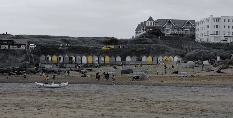
Bude Sea Pool & Summerleaze Beach – The Bude Sea Pool, set beneath the cliffs at Summerleaze Beach, is one of Bude’s defining landmarks. This semi-natural tidal pool offers a sheltered swimming spot protected from Atlantic swell, making it popular with families and cold-water swimmers alike.
Bude Canal – Running quietly through the town, the Bude Canal is a reminder of the town’s trading past. Today it provides flat, scenic walking and cycling routes, offering a peaceful contrast to the exposed coastline.
Castle Bude Museum & Heritage Centre – Castle Bude houses the town’s heritage centre and museum, with exhibitions covering maritime history, local life and coastal change. The surrounding grounds are also worth visiting for elevated views across the beach and sea.
Watersports
Bude is a well-established watersports hub, with opportunities for surfing, kayaking and stand-up paddleboarding. Local schools and hire centres cater for beginners and experienced paddlers alike, making it easy to get out on the water if conditions are right.
Beaches around Bude
Bude is particularly well placed for beach-hopping, with options ranging from family-friendly sands to remote, rugged coves.
In and around town
Summerleaze Beach – wide sands with easy access from the town and the sea pool
Crooklets Beach – popular with surfers, with reliable Atlantic waves
Nearby beaches
Widemouth Bay – a long, open bay just south of Bude, well known for surfing and coastal walks
Wilder and National Trust beaches
Sandymouth Beach – dramatic cliffs, rock formations and a mix of sand and shingle at low tide
Duckpool Beach – a remote, rocky beach backed by high cliffs, around six miles north
Northcott Mouth Beach – rugged and atmospheric, just over two miles north of town
South West Coast Path – Bude sits directly on the South West Coast Path, with clifftop walks leading north and south to dramatic headlands, secluded coves and wide Atlantic views. Routes range from short, scenic strolls to longer coastal hikes, making Bude a good base for exploring this section of the north Cornish coast.
From Bude to Boscastle
Leaving Bude, the Atlantic Highway begins to feel more enclosed as the road threads south through rolling farmland and wooded valleys. Just beyond Camelford, a short but scenic detour leaves the main route and drops towards the coast, leading into the steep-sided valley that hides Boscastle from view until the final approach.
By road: around 14 miles / 30–35 minutes, following the A39 before turning onto minor coastal roads
By bus: regular services link Bude and Boscastle, though journey times are slower and timetables can be seasonal
This short diversion marks the first real shift in character along the Atlantic Way — from open beaches and broad horizons to tight harbour villages, narrow valleys and dramatic cliff-backed coastline, setting the tone for the legendary stops that follow.
Boscastle - A dramatic harbour village carved into the cliffs
-
Getting there by road
Boscastle is reached via minor roads from the Atlantic Highway, turning off near Camelford. Roads are narrow and winding on the approach, adding to the sense of arrival but requiring slow, careful driving.
Parking
Parking in Boscastle is limited and tightly managed. The main car park sits above the village, with a steep walk down to the harbour. Arriving early or later in the afternoon is advisable in peak season.
Getting there by train
Boscastle does not have a railway station. The nearest stations are Bodmin Parkway and Exeter St Davids, with onward travel by bus or car.
Bus connections
Regular bus services link Boscastle with Bude, Tintagel and Wadebridge, making it one of the more accessible villages on this stretch of coast for walkers using public transport.
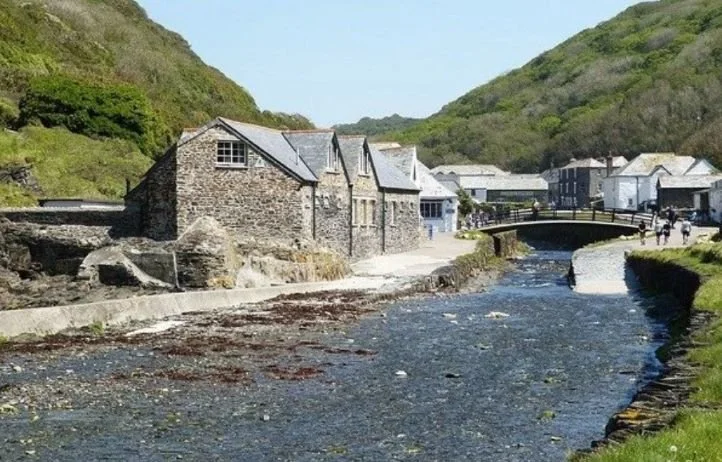
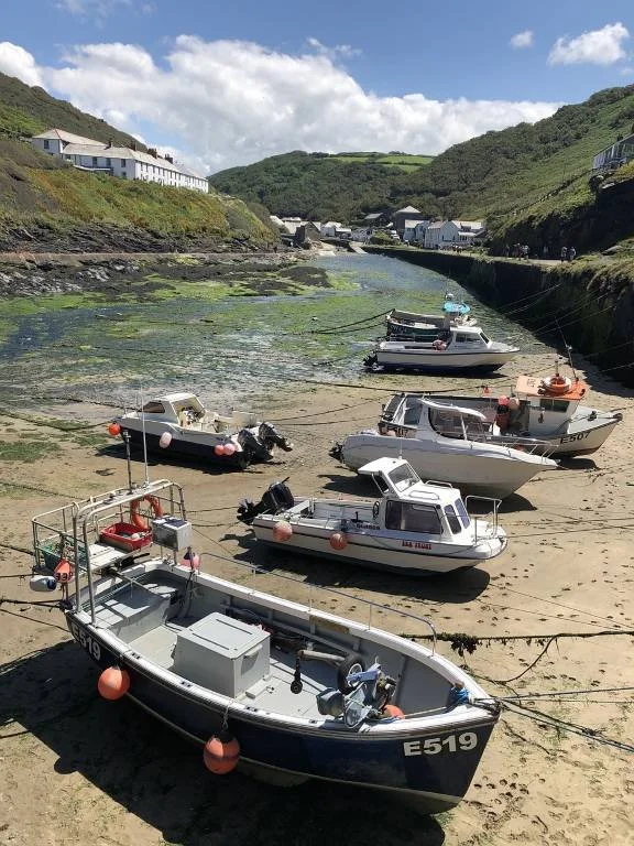
Boscastle is one of the most striking villages on Cornwall’s north coast, set deep within a narrow ravine where the River Valency meets the sea. Whitewashed cottages, slate roofs and a tightly enclosed harbour give the village a timeless feel, while the surrounding cliffs emphasise just how exposed and elemental this coastline can be.
Now cared for in large part by the National Trust, Boscastle rewards slow exploration — wandering the harbour, climbing to viewpoints, and following footpaths that reveal the scale of the landscape beyond the village.
What to see and do in Boscastle
The harbour & quay – The heart of the village, where fishing boats still shelter in the medieval harbour. It’s a compact area, best explored on foot, with cafés, galleries and small shops lining the approach.
The Lookout at Willapark – Identified by its white coastguard tower, this viewpoint above the harbour provides a classic perspective back over Boscastle and out to sea.
Witchcraft Museum – Home to the world’s largest collection of witchcraft artefacts, with more than 2,000 objects exploring folklore, ritual and belief. One of Cornwall’s most distinctive small museums.
Boscastle Pottery – Located close to the harbour, this historic workshop showcases locally made ceramics. Visitors can watch pottery being made and browse a wide range of handcrafted pieces.
Boat trips – In suitable conditions, short trips operate from the harbour, offering a chance to see the coastline from the water and spot wildlife such as seals and seabirds.
Hidden gem
The Devil’s Bellows (Boscastle Blowhole) – Beneath Penally Point, this natural blowhole sends a horizontal waterspout across the harbour entrance when conditions are right. The effect is most dramatic around an hour either side of low tide and makes for striking photographs.
Literary connections
Boscastle and the nearby Valency Valley have long inspired writers and artists. The area is closely linked with Thomas Hardy, who met his first wife Emma at St Juliot Church in 1870. The wild valleys, cliffs and coastal meadows surrounding Boscastle influenced several of Hardy’s works and remain a powerful part of the landscape today. St Juliot Church is where the poet Alfred, Lord Tennyson is buried.
South West Coast Path – The South West Coast Path runs directly through Boscastle, climbing steeply from the harbour in both directions. Heading north, the path rises to Penally Point, where a short but energetic climb rewards you with wide views back over the harbour and along the Atlantic coast. Heading south, the route leads to Willapark and its white lookout tower, offering one of the best viewpoints on this stretch of the coast. Both walks are relatively short but involve sustained climbs and uneven ground, making sturdy footwear essential.
From Boscastle to Tintagel
Leaving Boscastle, the route climbs steeply out of the harbour valley before rejoining the Atlantic Highway near Camelford. From here, a second short detour turns west towards the cliffs, leading to Tintagel and one of the most dramatic stretches of coastline on the north Cornish coast.
By road: around 5 miles / 15–20 minutes, using minor roads between Boscastle, the A39 and Tintagel
By bus: regular local services link Boscastle and Tintagel, though services can be limited outside peak season
This brief deviation takes you from a sheltered harbour village to exposed clifftops and wide Atlantic views, marking a shift from intimate, enclosed landscapes to one of Cornwall’s most legendary coastal settings.
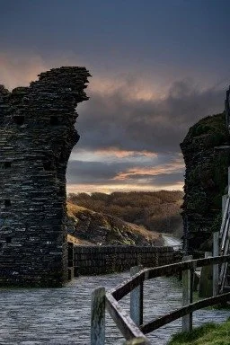
Tintagel - Legend, cliffs and one of Cornwall’s most dramatic historic sites

Tintagel is one of the most evocative places on the north Cornish coast, best known for its association with King Arthur and the spectacular ruins of Tintagel Castle. Set high above the Atlantic, the village combines powerful legend with dramatic coastal scenery, historic buildings and a lively high street of independent shops, galleries and cafés.
Reaching Tintagel involves a short detour from the Atlantic Highway, but the reward is one of the most memorable stops on the entire route.
The village is picturesque and located in a stunning beauty spot and houses galleries, gift shops and potteries to browse. Wander through Tintagel's charming streets and explore its eclectic mix of independent shops, galleries, and cafés. Pick up unique souvenirs, artisanal crafts, and locally-made products, and sample delicious Cornish treats at the town's eateries.
What to see and do in Tintagel
Tintagel Castle – One of Cornwall’s most iconic historic sites, dramatically split between the mainland and Tintagel Island. Access is via a striking footbridge spanning the chasm between land and headland. The ruins include remains of early medieval structures dating from the 5th–7th centuries, as well as later Norman fortifications. Below the cliffs lies Merlin’s Cave, accessible only at low tide.
Tintagel village – Beyond the castle, the village itself is worth time. Independent shops, galleries and cafés line the main street, offering locally made crafts, Cornish produce and Arthurian-themed curios.
National Trust’s Old Post Office – The Old Post Office Tintagel is a beautifully preserved 14th-century house cared for by the National Trust, with traditional interiors and a small medicinal garden.
St. Materiana's Church – Set on the cliffs above the castle, St Materiana’s Church is an ancient parish church with wide coastal views. Inside, look for the Roman inscribed milestone dating from the early 4th century.
King Arthur's Great Halls – A striking Victorian building celebrating Arthurian legend, with stained glass, carved panels and themed interiors.
Tintagel Toy Museum – A smaller, nostalgic stop showcasing vintage toys and games from across the 20th century.
-
Getting there by road
Tintagel is reached via minor roads branching off the Atlantic Highway near Camelford. Roads are narrow on the final approach, particularly busy in summer, and progress can be slow.
Parking
Parking is limited and well managed. Car parks are located on the edge of the village and near the castle approach, with steep walks involved. Arriving early or later in the afternoon helps avoid queues.
Getting there by train
Tintagel does not have a railway station. The nearest mainline station is Bodmin Parkway, with onward travel by bus or car.
Bus connections
Regular bus services link Tintagel with Boscastle, Camelford, Wadebridge and Bude, making it accessible for walkers and those combining driving with public transport.
Visiting tips
Allow at least half a day if visiting Tintagel Castle
Check tide times if you want to see Merlin’s Cave
Expect steep climbs between village, castle and coast path
The village is busiest late morning to mid-afternoon in peak season
-
Condolden Barrow & literary connections
Just above Tintagel Island lies Condolden Barrow, a Bronze Age burial mound around 26 metres in diameter. It features in Thomas Hardy’s The Queen of Cornwall, where Hardy imagines it as the grave of Cornwall’s queen. Historians suggest it is more likely linked to a high-status burial, possibly associated with early Cornish rulers.
South West Coast Path
South West Coast Path – Tintagel sits directly on the South West Coast Path, with cliff-top routes heading towards Boscastle in one direction and Trebarwith Strand in the other. Walks here are dramatic but involve steep ascents and uneven ground, so allow time and wear sturdy footwear.
From Tintagel to Camelford
(via Delabole Slate Quarry – optional detour)
Leaving Tintagel, the route turns inland, climbing away from the cliffs and rejoining the Atlantic Highway near Camelford. Before returning fully to the main road, a short inland detour leads to Delabole Slate Quarry, the largest working slate quarry in England and a fascinating insight into Cornwall’s industrial past.
Tintagel → Delabole: around 5 miles / 15 minutes
Delabole → Camelford: around 7 miles / 15 minutes
For those interested in geology or industrial heritage, Delabole offers a striking contrast to the coast — vast slate workings, viewing platforms and an on-site exhibition explaining how Cornish slate shaped towns and buildings across Britain.
Continuing on to Camelford, the landscape softens into rolling farmland and river valleys, and the Atlantic Way resumes its role as the main touring spine. Camelford works as a practical regrouping point on the route — a place to refuel, stock up, or decide which coastal detours to take next.
Delabole Slate Quarry: The Oldest and largest working slate quarry in England
-
The Delabole Slate Quarry holds the distinction of being one of the oldest working slate quarries in the world, with a history dating back to at least the 15th century. The quarry, in some guise, was recorded in the Domesday Book of 1086. At almost 500 feet deep and over 1.5 miles around, the quarry is one of the largest man-made holes in Europe - it is a fantastic site to visit. This historic quarry has played a significant role in the local economy and has been instrumental in shaping the landscape and architectural heritage of the region.
At its peak, the Delabole Quarry was a bustling centre of slate production, supplying roofing slate for buildings across the United Kingdom and beyond. The distinctive blue-grey slate extracted from the quarry was prized for its durability, weather resistance, and attractive appearance, making it a popular choice for both domestic and commercial construction projects.
-
Today, the Delabole Quarry continues to operate, albeit on a smaller scale, producing high-quality slate for a variety of applications, including roofing, flooring, and landscaping. Visitors to the quarry can take guided tours to learn about its history, geology, and the traditional methods used to extract and process the slate.
In addition to its industrial significance, the Delabole Quarry is also appreciated for its natural beauty and geological interest. The rugged landscape surrounding the quarry provides opportunities for hiking and exploring, with panoramic views of the Cornish coastline and countryside.
Visitors can observe the quarry from the pit viewing platform on a Quarry Tour.
Camelford - A historic market town and inland pause point on the Atlantic Way
Camelford sits just inland from Cornwall’s north coast, close to where the route rejoins the Atlantic Highway after the coastal detours to Boscastle and Tintagel. It works less as a headline destination and more as a practical regrouping point — a place to refuel, explore a little local history, or decide which direction to take next.
The compact town centre has a traditional Cornish feel, with small shops, cafés and historic buildings clustered around the main street.
What to see and do in Camelford
Camelford Town Centre & Town Hall – A short walk around the centre reveals Camelford’s historic role as a market town. The Town Hall, built in 1806, is a local landmark with its clock tower and distinctive golden camel weathervane. The building now serves as the town’s public library.
North Cornwall Museum building – Housed in a former coach and wagon workshop, this historic building reflects Camelford’s trading past. While the museum itself is now closed, the structure remains part of the town’s heritage streetscape.
River Camel & surrounding countryside – Camelford lies close to the upper reaches of the River Camel, with gentle walking routes leading out towards open moorland and farmland.
The Camel Trail
The Camel Trail – One of Cornwall’s most popular traffic-free walking and cycling routes, the Camel Trail follows a former railway line for around 18 miles, linking Bodmin, Wadebridge and Padstow.
While the main trail begins further south, Camelford sits close to the upper Camel Valley, where quieter riverside paths and short off-road sections allow you to sample the landscape without committing to the full route. For many travellers, this is the point where the Atlantic coast gives way to estuary and inland Cornwall, making the Camel Valley a natural transition.
Bodmin Moor - Alternative onward option from Camelford
If you’re not continuing south into the Fal River & Central Cornwall Corridor, Camelford also works as a natural gateway to Bodmin Moor. From here, short inland drives lead to open moorland, prehistoric sites and high granite tors such as Roughtor and Brown Willy.
This option suits travellers who prefer upland walking, archaeology and wide, empty landscapes, offering a quieter counterpoint to the busier coastal sections earlier in the route.
-
Camelford shows evidence of human settlement dating back to the Neolithic period, with nearby sites such as Roughtor and Brown Willy pointing to early habitation on Bodmin Moor.
The town developed as a medieval market centre, benefiting from its position near the River Camel and key inland routes. During the 19th century, Camelford played a supporting role in Cornwall’s mining industries, with tin, copper and slate extracted nearby — including slate from Delabole Slate Quarry, used on many local buildings.
-
Arthurian legend & Camelford
Camelford is often linked with the legends of King Arthur, partly due to its proximity to Tintagel and partly because of the similarity between the names Camelford and Camelot. In reality, the town’s name derives from the nearby River Camel, rather than legend.Those wishing to explore the Arthurian tradition further can visit the Arthurian Centre at Slaughterbridge, just outside Camelford, which focuses on storytelling, myth and the historic battle traditions associated with the area.
-
Getting there by road
Camelford sits directly on the A39, making it one of the easiest stops on the Atlantic Way to reach. It works well as a short pause between coastal detours.
Parking
Public car parks are available close to the town centre, generally easier to use than those in coastal villages.
Getting there by train
Camelford does not have a railway station. The nearest mainline station is Bodmin Parkway, with onward travel by bus or car.
Bus connections
Regular bus services link Camelford with Tintagel, Boscastle, Wadebridge, Padstow and Bodmin, making it a useful hub for travellers mixing driving and public transport.
From Camelford to Padstow
(with optional Camel Valley detour)
From Camelford, the route continues south on the Atlantic Highway, leaving the higher ground of north Cornwall and descending gradually towards the Camel Valley. This is a gentler stretch of the Atlantic Way, with broader roads, rolling farmland and long views replacing the tight coastal lanes of the earlier detours.
By road (direct): around 16 miles / 30–35 minutes via the A39 and local roads
By bus: regular services link Camelford, Wadebridge and Padstow, with longer journey times
Optional detour: the Camel Valley
Before reaching Padstow, you can detour into the Camel Valley, following the River Camel through wooded slopes, farmland and estuary landscapes. This area offers a slower, greener counterpoint to the coast, with opportunities for riverside walks, cycling and wildlife spotting.
Many travellers choose to join sections of the Camel Trail near Wadebridge, continuing towards the estuary before crossing to Padstow itself — a relaxed approach that contrasts nicely with the more exposed Atlantic-facing sections earlier in the journey.
Arriving in Padstow, the route shifts again in character: from inland valley to busy harbour town, marking the Atlantic Way’s transition from wild coastline to estuary and maritime life.
Explore the Camel Valley - A slower, greener detour between coast and countryside
-
For centuries, the Camel Valley was one of north Cornwall’s most important trading corridors. Tin, copper and agricultural goods once moved down the valley from inland settlements to coastal ports, particularly during the medieval tin trade. Farming communities thrived on the fertile riverbanks, shaping the patchwork landscape you see today.
Although its role as a transport route declined with modern roads, the valley’s history is still visible in old bridges, embankments and riverside settlements — now repurposed as walking and cycling routes rather than trade arteries.
-
Best for: walking, cycling, wildlife spotting, slower travel
Time needed: half a day for a short section, a full day for the Camel Trail highlights
Getting there: easiest access points are Wadebridge and Padstow
Terrain: flat along the Camel Trail; gentler than coastal paths
Good to know: tidal changes affect the estuary scenery but not trail access
When to include it in your itinerary
The Camel Valley works particularly well:
between Camelford and Padstow on the Atlantic Way
as a calmer alternative to a full coastal day
if you’re travelling with bikes or prefer level walking
It also acts as a natural transition point — easing the journey from wild north-coast cliffs into the more sheltered landscapes of central Cornwall.
The Camel Valley offers a complete change of pace from Cornwall’s exposed Atlantic coast. Following the gentle curves of the River Camel, the valley is characterised by wooded slopes, riverside meadows and estuary views, making it ideal for walking, cycling and unhurried exploration.
This is not a place to rush through. The Camel Valley works best as a half-day or full-day detour, particularly if you want a break from cliff paths and busy harbour towns.
How to experience the Camel Valley
The Camel Trail – The most accessible way to explore the valley is via the Camel Trail, an 18-mile traffic-free route following a former railway line between Bodmin, Wadebridge and Padstow. Flat and well surfaced, it suits walkers, cyclists and families, with bike hire available near Wadebridge and Padstow. For self-guided walking routes in the area, visit iwalk Cornwall.
Riverside walks – Shorter, quieter paths branch away from the main trail, especially in the upper valley closer to Camelford. These are ideal for peaceful walks with birdsong, woodland shade and frequent river views.
Estuary landscapes – As the river widens towards Padstow, the scenery opens out into saltmarsh and tidal creeks, with changing light and wildlife depending on the tide.
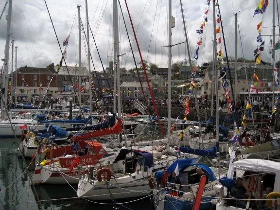
Padstow - Harbour life, food culture and the Camel Estuary
What to see and do in Padstow
Padstow Harbour & waterfront – The focus of the town, where fishing boats, pleasure craft and ferries move constantly across the estuary. It’s an easy place to spend time watching harbour life and soaking up the maritime atmosphere.
The Padstow–Rock ferry – The Padstow ferry runs frequently between Padstow and Rock, usually every 20 minutes during the day. It’s a simple way to explore both sides of the estuary without driving.
Padstow Museum – A compact but engaging museum covering the town’s fishing heritage, maritime history and everyday life along the estuary.
St. Petroc's Church – A historic parish church dating back to the 12th century, with a distinctive 15th-century tower and a peaceful churchyard.
Prideaux Place – An Elizabethan manor house completed in 1592, located just outside the centre. Visits focus on the house interiors and the surrounding grounds, once part of a deer park.
National Lobster Hatchery – A conservation and education centre working to protect lobster populations. Visits are short but informative and suit all ages.
Food & shops – Padstow is famous for its food culture, with seafood restaurants, bakeries and pasty shops clustered around the harbour. Alongside this are classic seaside shops selling ice cream, beach gear and souvenirs.
Rick Stein Restaurant - The Rick Stein restaurant was opened by Rick Stein and Jill Stein in 1975. The Seafood Restaurant is the place where his fame started. Known for serving the freshest fish and shellfish, sourced locally to make basic fish dishes with amazing flavours.
Hidden detail
Doom Bar – Just offshore lies the Doom Bar, a shifting sandbank at the mouth of the Camel Estuary that has been responsible for numerous shipwrecks over the centuries. While invisible at high tide, it’s an important part of Padstow’s maritime story.
The Camel Trail
Camel Trail – Padstow marks the coastal end of the Camel Trail, an 18-mile, largely flat route following a former railway line through Wadebridge to Bodmin. It’s ideal for walking and cycling (bike hire available on link), and provides one of the easiest ways to explore the Camel Valley at a relaxed pace.
Padstow is one of Cornwall’s best-known harbour towns, set on the north shore of the Camel Estuary. Long associated with fishing and trade, it’s now equally known for its food scene, lively waterfront and easy access to estuary walks and cycling routes.
The harbour sits at the heart of the town, framed by cafés, small shops and seafood restaurants, with steep streets rising behind it. Padstow works well as both a base for exploring the Camel Valley and a natural pause point on the Atlantic Way.
-
Getting there by road
Padstow is reached via local roads branching off the Atlantic Highway near Wadebridge. Roads narrow as you approach the town, and traffic can be heavy in peak season.
Parking
Parking is limited and well controlled. Main car parks sit on the edge of town, with a walk down to the harbour. Arriving early or later in the afternoon helps avoid queues in summer.
Getting there by train
Padstow does not have a railway station. The nearest mainline station is Bodmin Parkway, with onward travel by bus or car.
Bus connections
Regular bus services link Padstow with Wadebridge, Camelford, Tintagel and Newquay, making it a practical stop for those combining driving with public transport.
Visiting tips
Allow half a day to a full day, depending on whether you walk or cycle the Camel Trail
The harbour area is busiest late morning to mid-afternoon
Tides affect estuary views but not ferry crossings
Padstow works particularly well as an overnight stop on the Atlantic Way
-
History of Padstow
Padstow’s history stretches back to at least the Iron Age. In the 6th century it was associated with Saint Petroc, who founded a monastery here. The settlement later developed into an important medieval port and fishing centre, receiving a royal charter in the 13th century.The town experienced attacks during the 16th century and later declined as a major port, but reinvented itself in the 19th and 20th centuries as a seaside resort. Today, Padstow balances its fishing heritage with tourism and food culture, remaining one of Cornwall’s most recognisable harbour towns.
From Padstow to Newquay
Leaving Padstow, the route follows the Atlantic Highway south through the open landscapes of mid-Cornwall. This stretch is broader and more flowing than earlier sections, passing farmland and low hills as the coastline briefly pulls away before reasserting itself closer to Newquay.
By road: around 18 miles / 35–40 minutes, primarily via the A39
By bus: regular services connect Padstow, Wadebridge and Newquay, though journey times are longer
Along the way, short coastal detours lead to some of the north coast’s most recognisable scenery, including the dramatic sea stacks and clifftop viewpoints at Bedruthan Steps, as well as the broader, less crowded sands of Mawgan Porth. These quieter stops offer a more contemplative counterpoint before reaching Newquay.
As you approach Newquay, the Atlantic Way returns to the coast in a big way. Clifftop roads, wide sandy beaches and long surf lines replace the sheltered estuary of Padstow, marking a clear shift from tidal calm to one of Cornwall’s most energetic Atlantic-facing towns.
South West Coast Path – While the path does not pass directly through Padstow harbour, it can be joined just outside town at Hawker’s Cove, where the route leaves the Camel Estuary and follows the headlands north and south. Walks here are generally gentler than on the exposed north coast, offering wide views across the estuary mouth and out to the Atlantic.
Newquay - Surf beaches, coastal walking and Cornwall’s most energetic seaside town
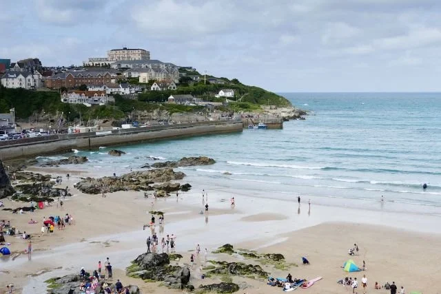
Newquay Newquay sits on Cornwall’s north coast at the mouth of the River Gannel, marking a clear shift in pace along the Atlantic Way. Where Padstow is shaped by estuary calm, Newquay faces the full force of the Atlantic — wider beaches, stronger swell and a livelier, more youthful atmosphere.
It’s best known for surfing, but Newquay also works as a base for coastal walks, family attractions and access to some of the county’s most expansive beaches.
What to see and do in Newquay
Beaches & surfing – Newquay is famous for its beaches, particularly Fistral Beach, one of the UK’s best-known surf beaches. Watergate Bay offers a long, open stretch of sand, while Lusty Glaze provides a more sheltered cove setting. Surf schools and board hire are widely available for all levels. See the accordion below for more.
Newquay Harbour – A smaller, working harbour where fishing boats still land their catch. It’s a good spot for a quieter wander, boat trips or seafood restaurants away from the main beaches.
Family attractions – Newquay Zoo is home to over 1,000 animals across themed habitats, while Blue Reef Aquarium offers an underwater tunnel and marine exhibits. Trenance Gardens provides a greener, calmer space with boating lakes and family activities. Lappa Valley is a world of play and trains where you can take a ride on the Woodland Railway, play golf and explore open-air play regions.
Nearby detours – Just north of town, Watergate Bay Hotel offers wide sands and a more open, less built-up feel, with coastal cafés and hotel viewpoints overlooking the Atlantic.
-
Getting there by road
Newquay is well connected by the A39 and A30, making it one of the easiest coastal towns to reach on this route. Expect heavier traffic in summer and at weekends.
Parking
Parking is available in multiple town-centre and beachside car parks, though they can fill quickly in peak season. Using peripheral car parks and walking in can be easier.
Getting there by train
Newquay has its own railway station with branch-line services connecting to Par and onward mainline routes.
Bus connections
Regular bus services link Newquay with Padstow, Wadebridge, Truro and St Ives, making it a practical stop for those combining driving with public transport.
Visiting tips
Allow half a day to two days, depending on whether you surf or walk
Beaches are busiest late morning to afternoon in summer
Early mornings and evenings offer a calmer coastal experience
Newquay works well as a short overnight stop before continuing west
-
Newquay’s reputation is built on its beaches. Facing directly onto the Atlantic, the coastline here offers a mix of high-energy surf beaches, sheltered town sands and quieter bays just beyond the main centre.
Fistral Beach – Widely regarded as the home of British surfing, Fistral Beach is known for the consistency and quality of its waves. It hosts national and international surf competitions and has surf schools, board hire and clifftop viewpoints overlooking the bay.
Towan Beach – Newquay’s central beach, easily accessed from the town centre. Towan is backed by cafés and shops and is best known for Towan Island, reached by a footbridge. At low tide, rock pools appear and the beach links with neighbouring sands.
Harbour Beach Newquay – A small, sheltered beach beside the harbour, ideal for calmer swimming and families. Its location makes it a good stop for a short beach break while exploring the harbour and town.
Tolcarne Beach – Set in a steep-sided cove below the cliffs, Tolcarne has a more enclosed feel. At low tide it connects with Great Western and Lusty Glaze, creating a longer stretch of sand for walking.
Lusty Glaze – A sheltered, horseshoe-shaped cove backed by high cliffs. Lusty Glaze is popular for swimming and events and was named Beach of the Year by The Times and The Sunday Times. Despite private ownership, it remains open to the public.
Polly Joke – A smaller, quieter bay north of Newquay, known for its wildflowers in late spring and early summer. It’s less developed than the town beaches and suits those seeking a calmer coastal walk or swim.
Penhale Sands – Located around 5 miles southwest of Newquay, this is one of Cornwall’s largest dune systems, stretching from Perranporth to Holywell. Backed by rolling dunes and wide open sands, it feels far removed from the town and is ideal for long walks and expansive beach days.
Choosing the right beach
For surfing: Fistral, Watergate Bay
For town access: Towan, Harbour Beach
For sheltered swimming: Lusty Glaze, Tolcarne
For space and quiet: Polly Joke, Penhale Sands
Together, these beaches show why Newquay remains the most varied and energetic beach destination on the Atlantic Way — offering everything from competition surf to wide, dune-backed sands just minutes apart.

South West Coast Path – Newquay sits directly on the South West Coast Path, with clifftop walks heading north towards Watergate Bay and south towards Crantock. This stretch offers dramatic views, sandy bays and a mix of easy promenades and more exposed headland walking.
From Newquay to St Ives
Leaving Newquay, the Atlantic Way gradually loosens its grip on the A39 and the route turns west, skirting the coast before cutting inland across the spine of west Cornwall. This final stretch of the Atlantic Way is less about dramatic detours and more about moving between landscapes — from surf beaches and exposed headlands to softer farmland and wide coastal bays.
By road: around 30 miles / 55–65 minutes, using a mix of A-roads and coastal routes
By train: the scenic branch line from St Erth to St Ives offers a relaxed alternative for part of the journey
By bus: services run between Newquay and St Ives, though travel times are longer than by car
While the Atlantic Highway officially ends near Newquay, many travellers continue west to St Ives, which works as a natural finishing point for the Atlantic Way before the route turns south into the Penwith Peninsula.
As you approach St Ives, the Atlantic Way gives way to a more intimate coastline — smaller bays, sheltered beaches and a town shaped as much by art and light as by the sea. This marks a natural pause point at the western end of the Atlantic Way, before the journey turns south into the Penwith & West Cornwall Loop.
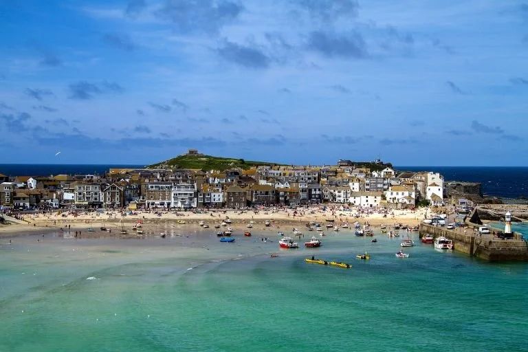
St Ives - Art, light and beaches at the western end of the Atlantic Way
What to see and do in St Ives
St Ives Harbour – The historic harbour remains the heart of the town, with fishing boats, galleries and cafés clustered around the water. A walk along the quayside offers classic views back across the bay and into the narrow streets behind.
St Ives Bay - A beautiful 6-mile crescent bay that stretches around to Godrevy Head.
Porthmeor Beach – St Ives’ most famous beach, popular for swimming, surfing and sunsets. Backed by the Tate St Ives, it offers wide sands and strong Atlantic views.
Porthminster Beach – More sheltered than Porthmeor, with calmer waters suited to swimming, kayaking and paddleboarding. It’s one of the town’s most accessible beaches.
Tate St Ives – One of Cornwall’s major cultural landmarks, Tate St Ives focuses on modern and contemporary art inspired by landscape, light and place.
Barbara Hepworth Museum and Sculpture Garden. – The former studio of Barbara Hepworth, now preserved as a museum, displaying sculptures in a tranquil garden setting.
St. Ives Museum – A small local museum near the harbour exploring the town’s maritime history, fishing heritage and artistic past.
St. Ives is one of Cornwall’s most distinctive seaside towns, celebrated for its exceptional light, artistic heritage and beautiful beaches. Set on a headland overlooking the sweeping curve of St Ives Bay, the town feels both intimate and expansive — a fitting finale to the Atlantic Way before the route turns south into Penwith.
Once a working fishing port, St Ives later became one of Britain’s most important artistic centres, a legacy that still shapes the town today.
South West Coast Path – St Ives sits directly on the South West Coast Path, with coastal walks leading east around the bay and towards headlands overlooking Godrevy Lighthouse. This stretch combines gentler gradients with wide, open views across sand and sea.
-
Getting there by road
St Ives is reached via local roads from the A30. Traffic restrictions operate in peak season, and driving into the centre is discouraged.
Parking
Parking is limited in town. The main visitor car park is at St Erth, where a park-and-ride train service runs directly into St Ives. This is the easiest option during busy periods.
Getting there by train
The scenic branch line from St Erth to St Ives is one of the most beautiful short rail journeys in the UK, running alongside the bay for much of the route.
Visiting tips
Allow at least half a day, ideally a full day or overnight
Arrive early or use park-and-ride in summer
Evenings are quieter and ideal for harbour walks
St Ives works well as a natural pause point before continuing south
-
Why artists came to St Ives
St Ives’ reputation as an artistic centre stems from its unique quality of light, coastal setting and sense of creative freedom. Clear skies, reflective sands and open horizons produce constantly shifting colour and shadow, long prized by painters and sculptors.The St Ives School of Artists
During the 20th century, St Ives became home to a loose collective of modernist artists known as the St Ives School. Figures such as Ben Nicholson, Patrick Heron, Terry Frost and Roger Hilton helped define modern British art through their work here.Institutions and legacy
The opening of Tate St Ives in 1993 cemented the town’s artistic reputation, while the Barbara Hepworth Museum preserves the working environment of one of Britain’s most influential sculptors. Together, they ensure St Ives remains both a place of inspiration and a living artistic community.
Godrevy Lighthouse

St Ives Bay is a beautiful 6-mile crescent bay that stretches around to Godrevy Head with the Godrevy Lighthouse - known as the motivation for the Virginia Woolf novel, To the Lighthouse.
You cannot visit Godrevy Lighthouse itself. The lighthouse stands on Godrevy Island, just offshore from Godrevy Head, and is not open to the public. There is no bridge or boat access for visitors.
What you can do — and what makes Godrevy special — is enjoy some of the best lighthouse views in Cornwall, combined with an excellent coastal walk.
The best way to experience Godrevy Lighthouse - From Godrevy Head (recommended)
The classic viewpoint is from Godrevy Head, where the lighthouse sits dramatically offshore across a narrow channel. This is the view most people recognise — waves breaking below, wide sands stretching across St Ives Bay, and the lighthouse framed against the Atlantic.
Access: short, mostly level walks from the National Trust car park
Surface: well-maintained coastal paths
Views: lighthouse, dunes, seals offshore on calm days
This area is managed by the National Trust.
Walk: South West Coast Path: St Ives → Godrevy
The South West Coast Path runs directly past Godrevy Head and connects naturally with St Ives.
Distance: approx. 3–4 miles one way (depending on route)
Difficulty: moderate, with gentle gradients compared to the north coast
Scenery: dunes, wide beaches, headlands and uninterrupted bay views
Many people walk one way and return by train from nearby stations, or simply walk a shorter out-and-back section from Godrevy.
Beaches and viewpoints nearby
Godrevy Beach – A wide, sandy beach backed by dunes, popular for walking and wildlife spotting rather than swimming. At low tide, the scale of the bay becomes especially apparent.
Dune paths & headland viewpoints – Multiple short paths branch from the main car park, making it easy to tailor the walk to your time and energy levels.
-
Getting there by road
Godrevy Head is accessed via local roads from Hayle and St Ives, well signposted for Godrevy and the National Trust site.
Parking
National Trust car park at Godrevy Head
Pay-and-display for non-members
Toilets available near the car park
Public transport
The closest stations are St Erth and Hayle, both on the St Ives Bay rail line. From there, walks or local buses connect to coastal paths.
Best time to visit
Clear days: best for lighthouse views
Rough seas: dramatic wave action around the island
Early morning or evening: quieter and great light for photography
Good to know
Dogs are often restricted on parts of the dunes seasonally
No access to the lighthouse itself
Exposed headland — bring windproof layers
Closing the Atlantic Way
From the wide beaches of Bude to the light-filled bays of St Ives, the Atlantic Way follows Cornwall’s north coast at its most open and exposed. Along the way, the route uses the Atlantic Highway as a backbone, branching off to harbour villages, clifftop landmarks and estuary towns that define this stretch of coast.
What begins as long horizons and surf-washed beaches gradually becomes more intimate. Harbours replace headlands, estuaries soften the coastline, and by the time you reach St Ives the journey has slowed — shaped as much by light, culture and walking as by driving.
St Ives works as a natural pause point. Some travellers choose to linger here, exploring beaches, galleries and coastal paths. Others continue south, where the character of the landscape shifts again.
Continuing into the Penwith & West Cornwall Loop
Leaving St Ives, the route turns away from the Atlantic spine and into Penwith, Cornwall’s most elemental peninsula. Here, granite headlands, tidal islands and exposed cliffs dominate, before the journey curves around Mount’s Bay and on towards the Lizard Peninsula.
Where the Atlantic Way is defined by distance and detours, the Penwith & West Cornwall Loop is about circling a landscape — slower, shorter in miles, but deeper in immersion. It’s a change of pace, and a reminder that Cornwall’s most dramatic scenery often rewards those willing to move more slowly.
Classic Cornwall Coast Last updated: 4 February 2026
Some links may earn Uncover Britain a small commission at no extra cost to you. This helps support the ongoing creation, review and presentation of our road trip guides.
Route information and listings are provided for general guidance only. Always use your preferred navigation system and check official websites to confirm suitability, opening times and the latest details before travelling.
Our guides are reviewed regularly and supported by a mix of editorial research and digital tools to help keep content clear and up to date. If you spot anything that needs updating, we’re always glad to hear from you.