


Customisable and Live Navigation via Google Maps –
click here:
Or use the links to jump to the destinations in the guide below
Glencoe →
Fort William →
Isle of Skye →
Plockton
Glencoe → Fort William → Isle of Skye → Plockton Approx distance: 289 miles (465 km), approx drivetime: 8 hours 15 mins
Chapter 3: Skye & the West Highlands - Mountains, Passes & the Big Landscapes
Whether you arrive here direct from Oban or emerge from the long, quiet roads of Ardnamurchan, this part of the journey feels like a return to something bigger, steeper and more vertical.
After the broken coast and outward-looking detours of the previous chapter, the road gathers itself again and turns inland. The sea falls away. Valleys narrow. The landscape begins to rise — first gently, then with sudden, unmistakable force.
For those coming from Ardnamurchan, this section marks a rejoining with the main Highland spine. For those who chose to bypass the islands, it is the moment when the west coast road trip truly becomes mountainous.
This is where the journey reaches its most dramatic landscapes.
Beyond the great passes of Glencoe and the shadow of Ben Nevis, the scenery becomes bolder, steeper and more elemental. Mountains rise more sharply from the land and the sea, the light becomes more theatrical, and the sense of scale grows again.
The Isle of Skye is the heart of this chapter — a place of extraordinary geological drama, where ridges, cliffs and vast open spaces seem to collide. The Cuillin mountains, the Trotternish peninsula and Skye’s long, broken coastline create some of the most powerful scenery in Britain, but also some of its quietest and emptiest roads.
The journey finishes in Plockton, where the landscape softens again and the sea becomes calm and reflective. It is a fitting end to a route that has moved steadily from sheltered lochs to the full scale of the western Highlands — a place where land, sea and sky feel inseparable.
How to Spend Your Time
From a whirlwind day trip to a relaxed seven-day immersion, these Isle of Skye itineraries cover all the essentials. Travel via ferry or bridge to discover iconic sights like the Old Man of Storr and Fairy Pools, explore historic castles such as Dunvegan, and admire sweeping vistas from the Quiraing to Neist Point. Whether you’re drawn to vibrant Portree, the secluded beauty of the Sleat Peninsula, or the rugged Cuillin mountains, Skye offers a rich tapestry of landscapes and cultural experiences.
-
Morning: Arrive via Skye Bridge or Ferry
Kyle of Lochalsh / Armadale: If coming by bridge, cross at Kyle of Lochalsh. If by ferry from Mallaig to Armadale, keep an eye on schedules.
Broadford: Quick coffee stop. Pick up snacks or supplies for the road.
Midday: Portree & Old Man of Storr
Portree: The island’s main town; stroll around the picturesque harbour and grab lunch.
Old Man of Storr: Short but steep hike for iconic rock pinnacles and sweeping views over the Sound of Raasay.
Afternoon: Kilt Rock & Quiraing (Optional)
Kilt Rock & Mealt Falls: A quick roadside viewpoint with waterfalls plunging into the sea.
Quiraing: A rugged landscape of pinnacles and plateaus. If time is tight, even a short walk from the car park offers dramatic scenery.
Evening: Depart or Optional Stop
Eilean Donan Castle (if returning via the bridge), or an evening ferry back to Mallaig.
Note: This 1-day plan is extremely packed. You’ll be moving quickly with minimal time at each site.
-
3-Day Itinerary
Day 1: Southern Skye & Sleat Peninsula
Morning:
Arrive via Mallaig–Armadale ferry or Skye Bridge.
Explore the Sleat Peninsula, often called the “Garden of Skye.” Possible stops include the Clan Donald Skye Visitor Centre at Armadale Castle.
Afternoon:
Drive to Broadford for lunch. Enjoy views over Broadford Bay.
Optional walk to the Kylerhea Otter Hide or a scenic drive along the narrow road to Kylerhea.
Evening:
Overnight in Broadford area, relaxing at a local inn.
Day 2: Cuillin Mountains & Portree
Morning:
Short hike near the Fairy Pools (Glen Brittle) or Sligachan for views of the Cuillin range. If you have time, a guided walk is available for more serious hikers.
Afternoon:
Head north to Portree, the island’s largest town. Check out shops, cafés, and harbour views.
Possible boat tour from Portree harbour to spot seals or sea eagles (in season).
Evening:
Stay in Portree, sampling local seafood and maybe catching live music at a pub.
Day 3: Trotternish Highlights
Morning:
Old Man of Storr hike. Start early to avoid crowds.
Midday:
Kilt Rock & Lealt Falls. Pack snacks or picnic for scenic stops.
Afternoon:
Quiraing: Walk part or all of the loop for jaw-dropping rock formations.
If time permits, visit the Museum of Island Life near Kilmuir or the Fairy Glen near Uig.
Evening:
Return to Portree or stay near Uig if departing by ferry to the Outer Hebrides the next day.
-
5-Day Itinerary
Day 1: Armadale & Sleat Peninsula
Morning:
Ferry from Mallaig to Armadale. Explore Armadale Castle & Gardens and the Clan Donald Skye Visitor Centre.
Afternoon:
Check out Sleat (pronounced “Slate”), known for its lush landscapes. Possible walk around Knock Castle ruins.
Evening:
Overnight in the Sleat Peninsula or Broadford area.
Day 2: Broadford & Elgol
Morning:
Drive to Elgol for a boat trip on Loch Coruisk (in season). The Cuillin mountains will loom dramatically over the loch.
Afternoon:
Return to Broadford, explore local craft shops or the Skye Serpentarium (small reptile exhibit).
Evening:
Stay in Broadford or move northward to Portree.
Day 3: Cuillin Mountains & Fairy Pools
Morning:
Go to Glen Brittle for the Fairy Pools. Enjoy the series of waterfalls and crystal-clear pools beneath the Cuillin range.
Afternoon:
Option for a longer hike in Sligachan if you’re an experienced walker. Alternatively, head to Portree to relax.
Evening:
Overnight in Portree.
Day 4: Trotternish Loop
All Day:
Focus on the Trotternish Peninsula. Stops include the Old Man of Storr, Lealt Falls, Kilt Rock, Quiraing, Staffin, and perhaps the Museum of Island Life.
Evening:
Return to Portree or stay in Uig.
Day 5: Dunvegan & Depart
Morning:
Head to Dunvegan Castle, seat of Clan MacLeod. Tour the castle, boat trip to see seals if time allows.
Afternoon:
Drive to Neist Point lighthouse for iconic coastal vistas (weather permitting).
Evening:
Return to your departure point—via Skye Bridge or Armadale ferry.
-
7-Day Itinerary
Day 1: Armadale & Sleat Peninsula
Morning:
Ferry crossing from Mallaig. Spend extra time at Armadale Castle & Gardens.
Afternoon:
Leisurely drive through Sleat, known for scenic forests and lochs. Possible stop at Sabhal Mòr Ostaig (Gaelic college) for cultural interest.
Evening:
Overnight in Sleat or Broadford.
Day 2: Elgol & Loch Coruisk
All Day:
Morning drive to Elgol. Take a boat trip (e.g., Bella Jane or Misty Isle) across Loch Scavaig to Loch Coruisk, a freshwater loch nestled among the Cuillin. Enjoy a short hike in this remote wilderness.
Evening:
Return to Broadford or Glen Brittle for the night.
Day 3: Glen Brittle & Fairy Pools
Morning:
Explore the Fairy Pools, take your time photographing or taking a dip if you’re brave.
Afternoon:
Possible trek or guided walk in the Cuillin foothills. Alternate: relax in Broadford, maybe visiting local art galleries.
Evening:
Travel north to Portree for a multi-night base.
Day 4: Portree Exploration
Morning:
Stroll through Portree’s colourful harbour. Consider a boat cruise to spot wildlife or simply browse local shops, cafés, and the Portree Art Centre.
Afternoon:
Take in the Aros Centre for cultural exhibitions or catch a local performance if available.
Evening:
Stay in Portree. Enjoy live music at a traditional pub.
Day 5: Trotternish Loop
All Day:
Visit the Old Man of Storr, Kilt Rock, Lealt Falls, the Quiraing, Staffin, and perhaps Uig. Allocate enough time for short hikes and scenic detours.
Evening:
Return to Portree or stay in Uig.
Day 6: Dunvegan & Neist Point
Morning:
Drive west to Dunvegan Castle, seat of Clan MacLeod. Tour the gardens, possibly take the seal boat trip.
Afternoon:
Continue to Neist Point for dramatic cliffs and lighthouse views. If time, explore the Coral Beach near Dunvegan.
Evening:
Overnight in Dunvegan area or return to Portree.
Day 7: Depart
Morning:
Any final stops—like Talisker Distillery near Carbost—if you haven’t visited yet.
Afternoon:
Drive back via Skye Bridge or ferry at Armadale.
Evening:
Conclude your 7-day adventure on Skye.
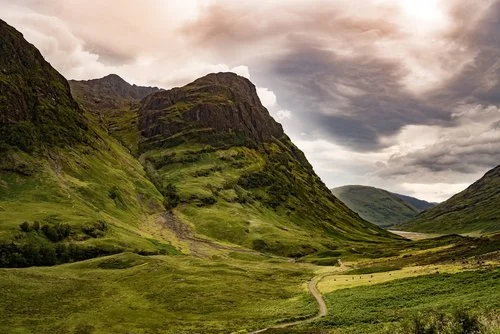
Glencoe - The Gateway to the Great Mountains
Glencoe is one of the most powerful and recognisable landscapes in Scotland — a vast, steep-sided glen where mountains rise abruptly from the valley floor and the road threads its way through a scene that feels both monumental and solemn.
This is the point in the journey where the west coast road trip truly enters the high mountains. Coming from the gentler lochs and broken coast, the change in scale is immediate and dramatic. The walls of the glen close in, the peaks grow sharper, and the sense of space becomes vertical rather than wide.
Glencoe is not just famous for its scenery. It is also one of the most emotionally charged places in the Highlands, shaped as much by history and memory as by ice and geology. The combination of natural grandeur and human tragedy gives the glen a depth and atmosphere that few places can match.
Whether you stop for a short walk, a viewpoint, or a longer hike, Glencoe is a place that demands time and attention rather than a quick drive-through.
One of the most dramatic mountain landscapes in Britain
The great gateway into the heart of the West Highlands
A place of powerful history and atmosphere
Outstanding short walks, viewpoints and serious mountain hikes
A world-famous scenic drive along the A82 through the glen
What to See & Do
Three Sisters of Glencoe – Three great ridges descending from Bidean nam Bian, forming the most iconic view in the glen and one of the most photographed mountain scenes in Scotland.
Buachaille Etive Mor – The great pyramid-shaped mountain that stands guard at the eastern entrance to Glencoe and signals the start of the high mountain country.
Lost Valley trail (Coire Gabhail) – A classic half-day walk into a hidden hanging valley once used by the MacDonalds to hide stolen cattle, combining history with spectacular scenery.
Scenic Drive on the A82 – The road through Glencoe is one of the most dramatic drives in Scotland, with frequent lay-bys and viewpoints where the scale of the landscape really hits home.
Glencoe Visitor Centre – A good place to learn about the glen’s geology, wildlife and history, and to get oriented before walking or driving deeper into the area.
Glencoe Mountain Resort - Is situated in an area of outstanding natural beauty on Rannoch Moor, with sweeping views of Buachaille Etive Mor.
Wildlife Watching – Red deer are commonly seen on the hillsides, and golden eagles, ravens and mountain hares are often spotted in the surrounding peaks.
Glencoe Massacre Monument - Commemorates the tragic events of 1692, and the ruins of Kilchurn Castle, a picturesque medieval fortress on the shores of Loch Awe.
Glencoe Folk Museum - Provides insight into local heritage and the Glencoe massacre of 1692, set within traditional 18th-century heather-thatched cottages.
-
Access:
Glencoe lies directly on the A82 between Tyndrum and Fort William, making it an unavoidable and natural stop on this route.Parking & Viewpoints:
There are numerous signed lay-bys and viewpoints along the glen, including at the Three Sisters and Buachaille Etive Mòr.Time Needed:
Allow 1–2 hours for a scenic drive and short stops, or half a day or more if you plan to walk.Safety:
Weather can change very quickly in the mountains. Good footwear, waterproofs and caution are essential even for short walks. -
For centuries, Glencoe was the territory of Clan MacDonald of Glencoe, one of the most important branches of the wider Clan Donald. The glen was shaped by a harsh mountain life based on cattle, kinship and survival, and by a clan system that dominated Highland society.
In the late 17th century, Scotland was caught up in political upheaval following the overthrow of King James VII and the rise of King William III. Clan loyalties were divided during the Jacobite period, and the MacDonalds of Glencoe became entangled in this dangerous uncertainty.
In 1692, government troops who had been quartered among the clan for nearly two weeks turned on their hosts, killing men, women and children in what became known as the Massacre of Glencoe. The event shocked Scotland and Europe, and has remained one of the most infamous episodes in Highland history.
Today, the story of the massacre gives Glencoe much of its haunting, solemn character — a place where extraordinary natural beauty and deep historical tragedy are inseparable.
Leaving Glencoe, the road continues north towards Fort William and Ben Nevis, where the journey shifts from passing through mountains to living among them for a while.
Fort William - Ben Nevis, the Great Glen & the Outdoor Capital of the Highlands
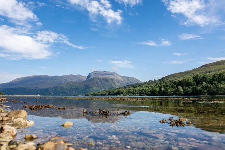
Fort William sits at a strategic crossroads where mountains, sea lochs and the Great Glen all meet. After the raw drama of Glencoe, it feels like a return to civilisation — but one that is still completely shaped by the surrounding landscape.
This is the outdoor capital of the Highlands and the natural base for exploring Ben Nevis, the Nevis Range and Glen Nevis. It is also a place with deep historical roots, tied to the control of the Great Glen and the turbulent aftermath of the Jacobite period.
Where Glencoe is about passing through a monumental landscape, Fort William is about staying, provisioning, and choosing your next direction — whether that’s west towards Skye, north into the Great Glen, or back into the mountains.
The main base town for Ben Nevis and the Nevis Range
Excellent access to Glen Nevis, Steall Falls and mountain walks
A hub for outdoor activities and Highland exploration
Strong Jacobite and military history
The point where the route turns west towards Skye
What to See & Do
Ben Nevis – At 1,345 metres, the highest mountain in the UK. A major undertaking to climb, but even from the lower slopes and visitor areas it dominates the entire region.
Glen Nevis & Steall Falls – One of the most beautiful glens in Scotland, with a superb walk to Steall Falls, one of the country’s highest waterfalls.
Nevis Range Mountain Resort – A year-round mountain area with a gondola lift offering spectacular views, plus walking, biking and winter snowsports.
Old Inverlochy Castle – Atmospheric ruins of a 13th-century castle near the River Lochy, tied to some of the most important battles in Highland history.
West Highland Museum – A small but excellent museum covering the history and culture of the West Highlands, including the Jacobite period.
Caledonian Canal – A 60-mile canal linking east and west Scotland through the Great Glen. Fort William is a great place for a short walk along the towpath or to watch boats pass through the locks.
Loch Linnhe Boat Trips – A chance to see the surrounding mountains and coast from the water, often with wildlife sightings along the way.
Highland Folk Museum is located about an hour's drive from Fort William, towards the Cairngorms if you are heading that way. It is an outdoor museum that depicts traditional Highland life through historic buildings and exhibitions.
-
Fort William grew around a government garrison built to control the Great Glen following the Jacobite uprisings. The original fortifications were part of a chain of strongholds designed to impose order on the Highlands. The town became an important military and administrative centre, and later a transport hub with the arrival of canals and railways. Although today it is best known for outdoor adventure, Fort William’s position and purpose have always been shaped by strategy, movement and control of the landscape.
-
Parking:
Fort William has several public car parks that are convenient for different parts of town and nearby attractions:Lynch’s Castle Car Park — Large, centrally located and close to the West Highland Museum, shops and cafés.
Corrie Park Car Park — Walkable to the waterfront, restaurants and boat trip departures on Loch Linnhe.
Old Station Garage / Glen Nevis Road Parking — Good for accessing Glen Nevis and Steall Falls walks.
Caledonian Canal Car Park (behind Neptune’s Staircase) — Ideal for canal-side walks and watching boats navigate the locks.
Nevis Range Car Park — At the base of the mountain gondola; best for mountain access but can fill early in summer and winter seasons.
Most of these are short walking distances from key town sights, and many offer free or low-cost parking (check local signage).
Time Needed:
Allow half a day to explore town and nearby attractions, or a full day if walking in Glen Nevis, visiting the Nevis Range, or taking a boat trip on Loch Linnhe.Facilities:
Fort William has a full range of supermarkets, cafés, restaurants, outdoor gear shops, toilets and accommodation options. It’s the most comprehensive service hub between Oban/Argyll and the Isle of Skye.Fuel & Supplies:
This is the last major service centre before crossing west towards Glenfinnan and Skye: a good place to top up fuel, food, outdoor essentials, and maps before heading into longer stretches of remote road. -
At 1,345 metres (4,413 ft), Ben Nevis is the highest mountain in the United Kingdom and one of the great landmarks of the Scottish Highlands. It dominates the landscape around Fort William and shapes both the town’s identity and its outdoor culture.
The most popular route to the summit is the Mountain Track (formerly the Tourist Path), which starts near the Glen Nevis Visitor Centre and climbs steadily for around 7–9 hours return. While it does not require technical climbing skills in good conditions, it is still a serious mountain walk that demands good fitness, navigation skills, proper clothing and careful attention to weather.
Even if you don’t plan to climb to the top, Ben Nevis is still very much part of the experience here. The lower glens, viewpoints, and surrounding paths offer superb scenery, and the mountain’s vast north face and cliffs can be appreciated from many points around Fort William and Glen Nevis.
In winter, conditions can be alpine and dangerous, and only experienced, well-equipped walkers and climbers should attempt the upper slopes. For many travellers, simply seeing Ben Nevis up close — and understanding its scale — is more than enough.
From Fort William, the journey turns decisively west. The road leaves the Great Glen, follows the shores of Loch Eil, and heads towards Glenfinnan and the crossing into Skye country — a shift from mountain strongholds to sea lochs, islands and broken coast once again.
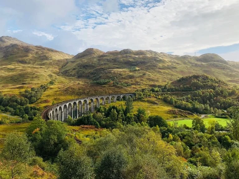
Glenfinnan - The Crossing West
Leaving Fort William, the road begins to follow the long, narrowing waters of Loch Eil before turning into a landscape shaped by lochs, hills and deepening silence. This is the point where the journey starts to feel more remote again — where towns thin out and the road begins to lean decisively towards the Atlantic.
Glenfinnan is not a town in the usual sense. It is a place of passage and memory, defined by two powerful landmarks: the Glenfinnan Viaduct and the Glenfinnan Monument. Together, they mark both a geographical crossing and a historical one — a threshold between the central Highlands and the western seaboard. There is a visitor centre near the viaduct that provides information about the history of the area, the construction of the viaduct, and its cinematic fame. There are several vantage points and hiking trails around the Glenfinnan Viaduct that allow visitors to capture the viaduct's beauty from different angles.
For many travellers, this is the moment when the west coast road trip truly turns towards islands, sea lochs and broken coastlines.
Home to the world-famous Glenfinnan Viaduct
Starting point of the Jacobite story in the west Highlands
A dramatic landscape of lochs and mountains
A key psychological and geographical gateway towards Skye and the west coast
One of the most photographed places in Scotland
-
Parking:
Glenfinnan Visitor Centre Car Park — Main car park with toilets, café and direct access to viewpoints and monument.
Viaduct Viewpoint Parking (Roadside Lay-bys) — Smaller informal spaces along the road for quick stops.
Time Needed:
Allow 45 minutes to 1.5 hours depending on whether you walk to the viewpoints and visit the monument.Best Time to Visit:
If you want to see the steam train, check the Jacobite Steam Train timetable in advance. Arrive early in peak season — it gets very busy.Facilities:
Visitor centre with café, toilets and small exhibition. -
Glenfinnan occupies a special place in Scottish history. In 1745, Bonnie Prince Charlie landed on the west coast and gathered Highland support for his attempt to reclaim the British throne. At Glenfinnan, he raised his standard at the head of Loch Shiel, formally launching the Jacobite Rising. Although the rebellion would ultimately end in defeat at Culloden, Glenfinnan remains a powerful symbol of Highland loyalty, loss and resistance. The monument standing today was erected in the 19th century to commemorate those who fought and died for the Jacobite cause.
-
Glenfinnan Viaduct – The iconic 21-arch railway bridge carrying the West Highland Line across the valley. It is famous worldwide as part of the route of the Jacobite Steam Train (often called the Hogwarts Express in the Harry Potter films).
The Jacobite Steam Train – Running between Fort William and Mallaig in season, this is one of the great scenic railway journeys in the world. Even if you’re not riding it, watching it cross the viaduct is a memorable sight.
Glenfinnan Monument – Standing at the head of Loch Shiel, this monument marks the spot where Bonnie Prince Charlie raised his standard in 1745, beginning the last Jacobite uprising.
Viewpoint Walks – Several short paths lead to elevated viewpoints overlooking the viaduct and Loch Shiel, perfect for photography and a short leg-stretch.
Crossing to Skye — Or Staying on the Mainland
Choosing Your Route West
From Glenfinnan, the journey reaches a natural fork in the road.
Up to this point, the route has flowed in a single, inevitable direction — but here, you have a choice:
Turn west and cross to the Isle of Skye, committing to one of the most dramatic island landscapes in Britain
Or stay on the mainland, following quieter roads through sea lochs and coastal mountains towards Plockton.
Both options are outstanding. The difference is not quality, but time, pace and character.
Option 1: Cross to the Isle of Skye (The Full Experience)
Choose this if you have time and want the most spectacular and iconic landscapes of the west coast.
From Glenfinnan, you head west and north through a landscape of long sea lochs and mountain walls towards Kyle of Lochalsh or Glenelg, depending on your chosen crossing.
Before you even reach Skye itself, the journey gives you two of the great threshold moments of the Highlands:
Eilean Donan Castle — the most famous castle in Scotland, standing where three sea lochs meet
The crossing itself — either by bridge or by ferry
Two Ways to Reach Skye
The Skye Bridge (via Kyle of Lochalsh)
The fastest and simplest route. You cross directly onto Skye at Kyleakin and continue your journey without delay.
The Glenelg–Kylerhea Ferry
A slower, more atmospheric crossing on the world’s last turntable ferry. This route brings you onto Skye at Kylerhea and offers one of the best chances to see otters, seals and sea eagles. It also allows a visit to the Kylerhea Otter Hide immediately after landing.
Both routes lead you onto Skye — the choice is between speed and simplicity or character and wildlife.
Option 2: Stay on the Mainland (The Quieter Alternative)
If time is short, or you prefer a calmer, less crowded route, you can skip Skye entirely and stay on the mainland.
From Glenfinnan, you continue north-west through a beautiful sequence of sea lochs, mountain passes and empty roads, heading towards:
Plockton (click to jump to Plockton) — one of the prettiest villages in the Highlands, which marks the end of this road trip guide.
The Applecross Peninsula (if continuing further)
Or onward into the far northwest Highlands
This route still delivers big scenery and coastal landscapes, but without the ferry queues, bridge crossings or Skye crowds.
It is not a compromise — just a different style of journey.
How to Choose
Choose Skye if:
You have at least 3–5 days for this part of the trip
You want the most dramatic landscapes
You don’t mind busier roads and popular sights
Choose Mainland Only if:
You are short on time
You prefer quieter roads and fewer people
You want a smoother, more relaxed pace
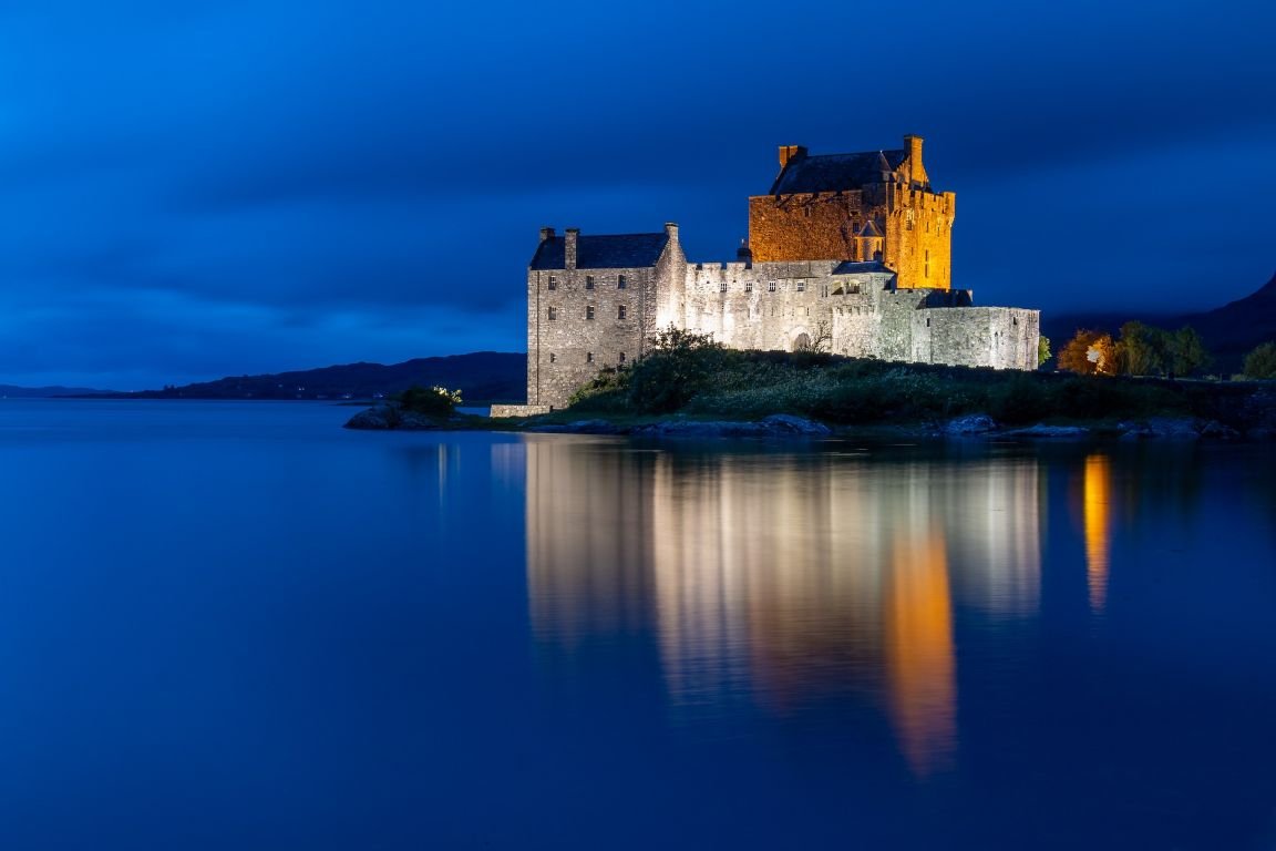
Eilean Donan Castle (Kyle of Lochalsh)- The Gateway to Skye
Eilean Donan Castle is one of the most recognisable and photographed castles in Scotland, standing on a small tidal island where three sea lochs meet — Loch Duich, Loch Long and Loch Alsh — framed by the mountains of the west Highlands.
For most travellers heading towards Skye, this is the great threshold moment: the point where the mainland begins to give way to islands, sea crossings and more broken, dramatic landscapes. Whether you cross to Skye by bridge or ferry, Eilean Donan feels like the ceremonial gateway to that world.
The castle’s setting is as powerful as its history. Mountains rise behind it, water surrounds it, and the changing light constantly transforms the scene. Even for visitors who don’t go inside, it is an unforgettable place to stop, walk, and take in the scale and atmosphere of the west Highlands.
One of the most iconic castles in Scotland
Dramatic tidal island setting at the meeting point of three sea lochs
A perfect photography stop and short walk
A powerful symbolic gateway to Skye and the northwest
Easy to visit directly from the main road west
Access: Reached via a stone footbridge from the mainland; parking is close by.
Best time to visit: Early morning or late afternoon for quieter conditions and the best light for photos.
Allow time for: Exploring the interior rooms, coastal viewpoints, and short walks around the shoreline.
-
The Castle Exterior & Causeway – Walk across the stone bridge to the island and explore the shoreline viewpoints around the castle for classic photographs.
The Interior Rooms – The restored interior includes furnished rooms, exhibitions and artefacts that bring the castle’s long history to life.
Loch & Mountain Views – The surrounding landscape is a constant interplay of water, peaks and sky, making this one of the most visually dramatic stops on the entire route.
Short Walks Around the Shore – Easy paths and viewpoints nearby offer quieter angles and wider views than the main approach.
-
Access:
Reached by a stone footbridge from the mainland.Parking:
Large, well-signposted Eilean Donan Visitor Car Park beside the road, with visitor facilities and a short walk to the castle.Time Needed:
Allow 30–45 minutes for exterior views and photos, or 1.5–2 hours if visiting the interior.Best Time to Visit:
Early morning or late afternoon offers quieter conditions and the best light for photography.Facilities:
Visitor centre, café, shop and toilets on site. -
The site has been fortified since at least the 13th century, originally built to guard the lands of Kintail against Viking raids. Over the centuries it became associated with Clan Mackenzie and later Clan MacRae. The castle was badly damaged during Jacobite-related conflicts in the early 18th century and lay in ruins for nearly 200 years before being carefully rebuilt in the early 20th century. Today’s castle is a sensitive reconstruction that combines medieval origins with later Highland history, creating the iconic landmark seen today.
From Eilean Donan, the journey reaches its final choice point:
Continue a short distance to Kyle of Lochalsh and cross the Skye Bridge, or
Turn south-west towards Glenelg and take the Kylerhea ferry for a slower, more atmospheric crossing.
Either way, the next chapter of the journey lies across the water.
Crossing to Skye
Bridge or Ferry?
From Eilean Donan Castle, the road gives you one last choice before the island world begins.
Skye is close now — but how you reach it changes the character of the journey.
You can cross quickly and simply by bridge, or you can take one of the most atmospheric short ferry crossings in Scotland. Both get you to Skye. The difference is speed versus experience.
Option 1: The Skye Bridge (Fast & Direct)
The most straightforward route is to continue north to Kyle of Lochalsh and cross the Skye Bridge at Kyleakin.
No ferry schedules
No waiting times
Open 24/7
The fastest and most reliable option in all weather
This is the best choice if:
You’re short on time
You’re travelling outside the main season
You want to get straight onto Skye and begin exploring
Once across, you are immediately on the southeastern edge of Skye and can begin heading north or west across the island.
Option 2: The Glenelg–Kylerhea Ferry (Slow & Scenic)
For a much more characterful approach, turn south-west from Eilean Donan towards Glenelg and take the Glenelg–Kylerhea ferry.
This is the world’s last manually operated turntable ferry, carrying a small number of vehicles across the narrow strait to Kylerhea on Skye.
Short crossing, but very atmospheric
Excellent chances of seeing seals, otters and sea eagles
Feels like a true island arrival, not just a road crossing
This is the best choice if:
You have a bit more time
You enjoy quieter, slower travel
You want wildlife and a sense of occasion when arriving on Skye
If you arrive on Skye via the Glenelg ferry, you’re just a short walk from the Kylerhea Otter Hide.
-
A Quiet Welcome to Skye
Tucked away on the narrow strait between the mainland and Skye, the Kylerhea Otter Hide is one of the most peaceful and rewarding wildlife stops on the entire west coast journey.
If you arrive on Skye via the Glenelg–Kylerhea ferry, this is quite literally your first step onto the island — and it couldn’t be more fitting. The hide overlooks a sheltered stretch of shoreline where otters regularly hunt along the rocks and kelp beds, often in the soft light of early morning or late afternoon.
This is not a busy attraction or a guaranteed sighting. It’s a place for patience, quiet and watching the tide line, and it perfectly sets the tone for the slower, more observant pace of travel that Skye rewards.
Why Stop at Kylerhea Otter Hide
One of the best places in Scotland to spot wild otters
A peaceful, low-effort walk right after arriving on Skye
Binoculars provided in the hide
Excellent chances of seeing seals and seabirds as well
A perfect slow, wildlife-focused introduction to the island
What to See & Do
Wildlife Watching from the Hide – Settle in and scan the shoreline and tidal currents for otters, seals and seabirds. The hide is well-positioned and sheltered, making it comfortable even in cooler weather.
Coastal Woodland Walk – The walk to the hide passes through quiet woodland and along the shore, adding to the sense of stepping away from roads and into nature.
Photography & Quiet Time – Even if otters don’t appear, the setting is beautiful and calm, with constantly changing light and water.
-
Location:
Near Kylerhea, on the Skye side of the Glenelg–Kylerhea ferry crossing.Parking:
Small parking area near the ferry slipway on the Skye side.Walk:
Around 2 km return, taking about 30–40 minutes in total. The first section climbs steeply uphill before easing into a gentler woodland path.Best Time to Visit:
Early morning or late afternoon offer the best chance of seeing otters.What to Bring:
Sturdy shoes (the path can be muddy), patience, and quiet voices.Facilities:
None at the hide — bring everything you need with you.
Once you arrive on Skye, the journey shifts again — into a landscape of ridges, cliffs, long coastlines and extraordinary geology. The road no longer follows simple corridors, but breaks into loops, peninsulas and dead ends.
Isle of Skye (West Coast Edition)
Skye does not ease you in.
After the long road through the west Highlands, the island rises out of the sea in a sudden collision of ridges, cliffs and vast open spaces. The light feels sharper here. The distances feel bigger. The landscape seems less settled, more elemental, and constantly in motion.
This is not a place you can “do” properly in a day or two — Skye deserves a journey of its own. But as part of the west coast route, it offers something extraordinary: a concentrated encounter with some of the most dramatic scenery in Britain.
In this guide, Skye is a deliberate, curated interlude — a two-day loop that focuses on its most immediately powerful landscapes before the road turns back towards quieter shores and softer light.
Think of it not as trying to understand Skye, but as meeting it properly for the first time.
Two-Day Taste of Skye
Day 1 – The Trotternish Peninsula
If you only see one part of Skye on a short visit, it should be the Trotternish Peninsula.
This long, rugged finger of land on the island’s northern edge is a landscape shaped by ancient landslips and collapsing cliffs, where the earth seems to have folded, buckled and broken in slow motion. The result is one of the strangest and most powerful geological landscapes in Europe — a place of sudden escarpments, isolated rock towers and vast, empty views over sea and sky.
Day 1 is not about ticking off attractions. It’s about driving slowly through a landscape that looks and feels like nowhere else.
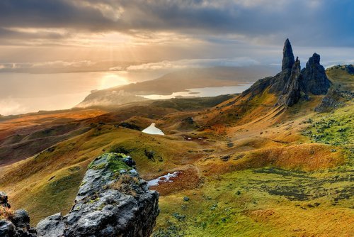
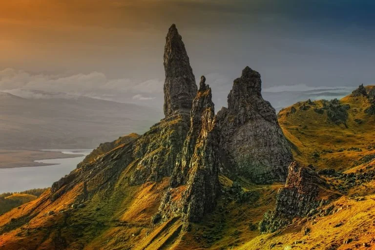
Old Man of Storr - The First Shock of Scale
The Old Man of Storr is Skye’s most famous landmark — a huge rock pinnacle standing on the edge of the Trotternish escarpment, visible from miles away.
Even if you don’t do the full walk, the sense of scale here is immediate and overwhelming. The cliffs drop away beneath you, the Sound of Raasay opens out to the east, and the spine of the island stretches away into the distance.
For those who do walk, the well-made path climbs steadily to a viewpoint where the full drama of the formation and the surrounding cliffs really reveals itself. It’s a demanding but achievable walk in good conditions — and one of the great classic viewpoints in Scotland.
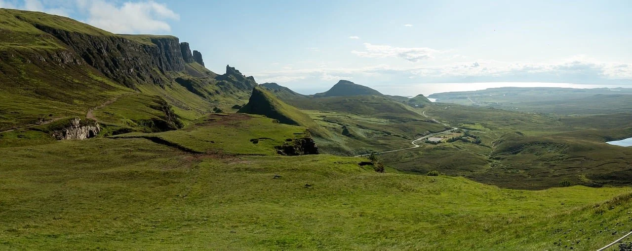
The Quiraing - A Landscape That Shouldn’t Exist
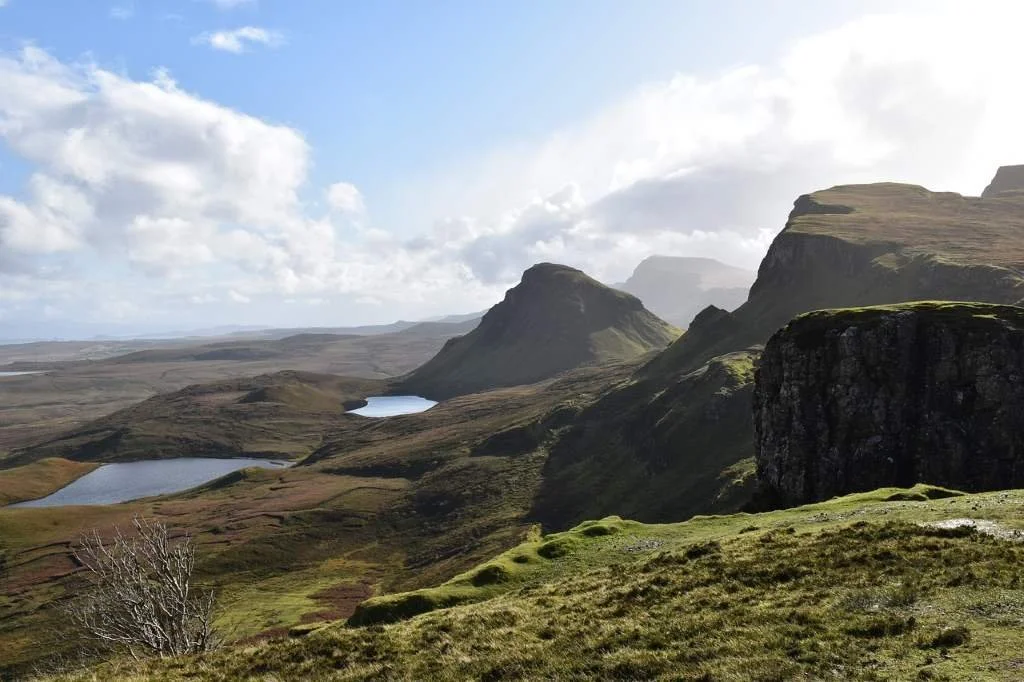
Further north, the road climbs into the Quiraing , a place that feels less like scenery and more like a rupture in the surface of the world.
Here, vast slabs of land have slipped and twisted, creating a labyrinth of pinnacles, hidden plateaus, sheer drops and strange, isolated hills. The views stretch across the north of Skye to the Outer Hebrides, and in changing light the whole landscape seems to shift and reassemble itself.
You don’t need to walk far to feel the impact of this place. Simply driving into the Quiraing and stopping at a few viewpoints is enough to understand why this is one of the most photographed — and most unsettling — landscapes in Scotland.
The Trotternish Ridge Drive
A Day of Big Landscapes, Not Small Stops
What ties Day 1 together is not individual sights, but the journey itself.
The road around the Trotternish Peninsula is one of the great scenic drives of the Highlands: a constant sequence of cliffs, open moorland, sudden drops to the sea and vast skies. It’s a day to go slowly, to stop often, and to let the scale of the place do the work.
By the end of the day, Skye will already have changed the way the west coast journey feels.
Where to Stay
For this two-day loop, it makes sense to base yourself around Portree or northern Skye, keeping driving distances manageable and allowing a relaxed pace.
After a day spent in Skye’s most extreme landscapes, the journey shifts again — away from pure geology and back towards history, human stories and the Atlantic edge on the island’s western side.
Day 2 – Castles, Cliffs & the Atlantic Edge
After the raw, geological drama of Trotternish, Day 2 brings a change of tone.
The road turns west across the island, and the landscape begins to open out into long sea views, gentler slopes and wide Atlantic horizons. This is a day about contrast — pairing Skye’s human history with one final, unforgettable coastal edge before the journey turns back to the mainland.
Dunvegan Castle - Skye’s Great Stronghold
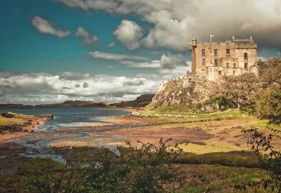
Dunvegan Castle & Gardens is the ancestral home of MacLeod Clan and has been occupied by the same family for over 800 years, making it one of the longest continuously inhabited castles in Scotland.
Standing above Loch Dunvegan, it feels less like a romantic ruin and more like a working stronghold — a reminder that Skye’s history is not just geological, but deeply human. Inside, you’ll find historic rooms, clan relics and stories that bring centuries of island life and conflict into focus.
Even if you don’t tour the interior, the setting alone — water, hills and shifting light — makes Dunvegan a rewarding stop and a perfect counterpoint to the wild landscapes of Day 1.
Neist Point - The Edge of the Island
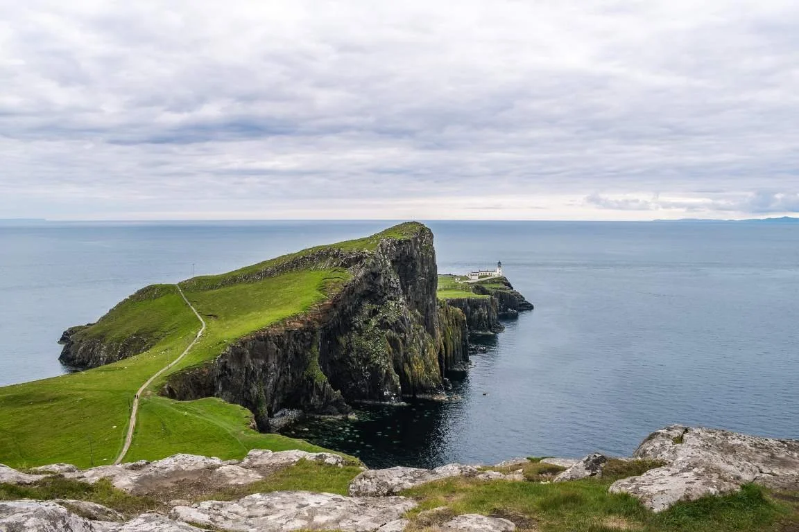
rom Dunvegan, the road continues west to Neist Point, where Skye ends in a dramatic sweep of cliffs and open Atlantic.
The lighthouse stands on a headland that feels properly exposed — a place of wind, space and huge skies. The walk down to the viewpoint is steep but short, and the reward is one of the most powerful coastal views on the island.
On a clear day, you can see far out into the Atlantic, and the sense of standing at the very edge of land and road is unmistakable. It’s a fitting final Skye moment before the journey begins to turn away from the island.
Optional Detour: Armadale Castle & the Museum of the Isles
If you are arriving on Skye from Mallaig or leaving by ferry, Armadale Castle makes an excellent first or last stop on the island.
Set in sheltered gardens near the southern tip of Skye, Armadale was once the seat of the Macdonalds of Sleat and is now home to the Museum of the Isles, which tells the story of Clan Donald and the wider history of the Highlands and Islands.
However, Armadale is well away from the Trotternish and Dunvegan loop, and visiting it as part of a short two-day Skye itinerary involves a significant detour. It’s best included only if you have extra time, or if your route already takes you through southern Skye.
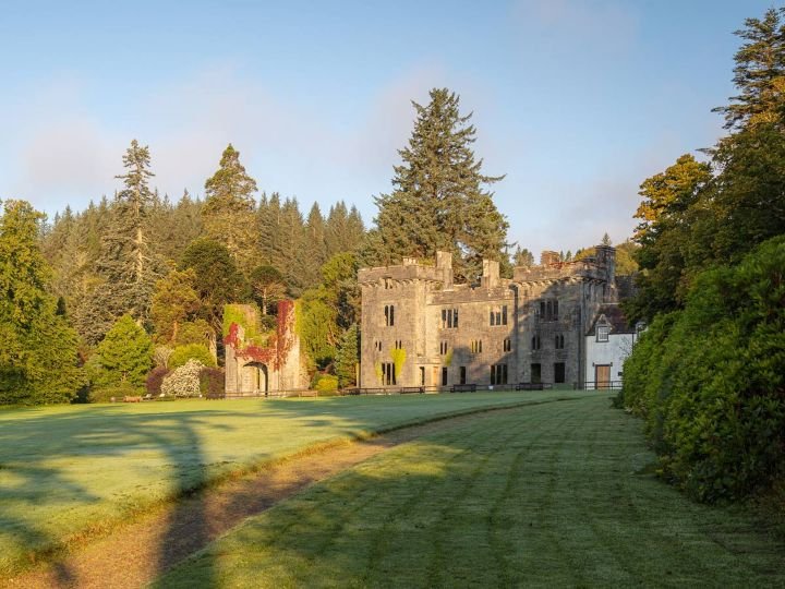
Image copyright: Armdale Castle
The historic Armadale Castle was once the seat of the Macdonalds of Sleat, part of the strong Clan Donald. The gardens were initially spread out by Lord Macdonald in the mid-19th century, where you can wander 40 acres of woodland, bushes, and blossoms, in a shielded microclimate.
In the award-winning Museum, discover the history of the Highlands and Islands through the account of Clan Donald, its most powerful family. Learn about 1500 years of history.
The Museum, Gardens, and Bothy Blend outdoor café are open from Wednesday to Sunday. Tickets are available at the gate, rather in advance.
-
Armadale Castle stands on the historic lands of Clan Donald, one of the most powerful and influential clans in Highland history. For centuries, the Macdonalds were not just local chiefs but Lords of the Isles, ruling much of western Scotland from the Hebrides to the mainland coast, often as semi-independent rulers in their own right.
The site at Armadale has been associated with the Macdonalds since at least the 15th century, although the present ruins belong to a much later mansion house built in the early 19th century. By this time, the political power of the Lords of the Isles had long been broken by the Scottish Crown, but the Macdonalds of Sleat remained one of the most important branches of the clan.
The 19th-century Armadale House was intended as a grand family seat, reflecting the clan’s status and heritage. However, like many Highland estates, it became increasingly expensive to maintain, and parts of the building fell into disuse. Today, the romantic ruins stand as a reminder of both the ambition and the later decline of the great Highland clan houses.
The wider story told here goes far beyond one building. The Museum of the Isles traces over 1,500 years of Highland and Island history, including:
The rise and fall of the Lords of the Isles
Clan warfare and shifting alliances
The impact of the Jacobite rebellions
The devastating social changes of the Highland Clearances
Emigration and the Highland diaspora across the world
This makes Armadale not just a castle visit, but one of the best places on Skye to understand the human history of the Highlands.
The surrounding gardens and woodland, laid out in the 19th century, benefit from a sheltered coastal climate and now form one of the richest and most peaceful walking areas in southern Skye, combining coastal views, mature trees and carefully curated plantings.
Today, Armadale Castle is less about battlements and interiors, and more about landscape, memory, and identity — a place where the story of Clan Donald and the wider Highlands is told in depth and with context.
A Lighter Touch on Skye
In this West Coast of Scotland road trip, the Isle of Skye is included as a highlight rather than the main focus. This guide gives you a carefully chosen, easy-to-follow 2-day route across Skye, designed to fit naturally into a much longer west coast journey without overwhelming the rest of the trip.
If you want to explore Skye in much greater depth, we also offer a dedicated Isle of Skye Road Trip Guide, which:
Covers 204 miles (331 km) around the island
Includes 25 key destinations and hundreds of detailed references
Explores the Sleat Peninsula, the full Trotternish loop, and far more beyond
You can add the full Skye guide to your account at any time, and access in the same way for an additional cost and turn this short Skye section into a complete, in-depth island adventure.
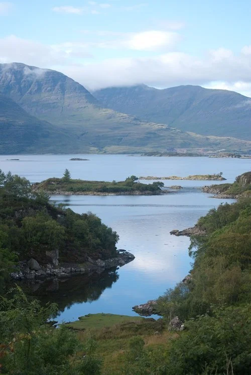
Plockton
Plockton sits in a sheltered bay on the edge of Loch Carron, facing across calm water to the Applecross mountains. After the scale and drama of Skye and the western Highlands, it feels like a place where the journey exhales.
Often described as one of the prettiest villages in Scotland, Plockton is known for its palm trees, white cottages, and peaceful waterfront, all made possible by the warming influence of the Gulf Stream. The setting is unexpectedly gentle: a quiet harbour, still water, and long views rather than cliffs and peaks.
It’s a perfect place to slow down, walk by the shore, have a good meal, and reflect on the journey you’ve just completed — and a fitting end to a route that began among lochs and grew steadily wilder and more dramatic.
One of Scotland’s most scenic and tranquil harbour villages
A complete contrast to Skye’s wild landscapes and mountain drama
Beautiful waterfront walks with views to Applecross and Loch Carron
Excellent seafood and relaxed places to eat and stay
A calm, graceful place to end a big west coast journey
What to See & Do
Plockton Harbour – A sheltered, palm-lined harbour with colourful boats, reflections in still water, and benches for simply sitting and watching the light change across the loch.
Harbour & Coastal Walks – Easy, level walks around the shoreline and out towards the edges of the bay, perfect for stretching your legs without committing to a hike.
Boat Trips on Loch Carron – Local boat trips explore the sheltered waters of the loch and often spot seals and seabirds.
Seafood & Local Restaurants – Plockton is known for its seafood, especially fresh shellfish, and makes a great place for a final celebratory meal.
Kyle of Lochalsh (nearby) – If you need supplies, fuel or onward connections, Kyle is just a short drive away.
Balmacara Estate - A beautiful National Trust for Scotland estate overlooking Loch Alsh, with peaceful woodland and shoreline walks plus wide views towards Skye.
Lochalsh Woodland Garden - specialises in Himalayan and far eastern plants and has views of Skye.
Craig Highland Farm - midway between Plockton and Stromeferry, is a conservation centre with 17 acres, rare breeds of Scottish sheep, llamas and peacocks.
A Journey That Stays With You
The West Coast of Scotland is not a place you simply pass through. It’s a landscape that unfolds slowly and deliberately — from sheltered lochs and wooded glens, to broken coastlines, mountain passes, islands, and finally back to calm water and quiet harbours.
Over the course of this journey, you’ve followed roads shaped by geography rather than convenience, crossed seas instead of valleys, and watched the country change in scale, mood and light. You’ve moved from gentle beginnings at Loch Lomond, through the islands and peninsulas of the west, into the great mountain spaces of Glencoe and Skye — and finally into the soft, reflective calm of Plockton.
This is a route about distance, space, and transition. It rewards patience, curiosity, and the willingness to take the slower road. And long after the driving ends, it’s the feeling of the journey — not just the places — that tends to stay with you.
Continuing Your Journey Around Scotland
If this road trip has left you wanting to explore more of Scotland, there are several natural ways to continue.
If Skye captured your imagination, our Isle of Skye Road Trip offers a much more in-depth journey around the island, covering the Sleat Peninsula, the full Trotternish loop, and many quieter corners that reward a slower, more immersive visit.
If you’re heading north, the North Coast 500 begins in Inverness and traces a spectacular loop around Scotland’s far north — a route of wild cliffs, empty beaches, great headlands and some of the most remote driving in Britain.
If you’re travelling south or east instead, Edinburgh & the Borders offers a softer, more historical journey through castles, abbeys, rolling hills and some of Scotland’s most story-rich landscapes. And if you’re returning down the east coast, the Kingdom of Fife makes a beautiful final chapter — a coastline of fishing villages, golf links, beaches and historic towns, crowned by the old royal capital of St Andrews.
Together, these routes let you explore Scotland not as a checklist, but as a series of journeys — each with its own character, rhythm and sense of place.
On Your Way To or From Scotland
If you’re building a longer journey from England, several routes connect beautifully into this west coast adventure:
Northumberland Castles & Coast — A dramatic frontier coastline of castles, wide beaches and big skies
North Yorkshire Moors & Coast — Moorland landscapes, steam railways and classic seaside towns
Yorkshire Dales & West Yorkshire — Limestone valleys, Pennine hills, literary towns, industrial heritage and big, open moorland landscapes
Peak District — England’s first national park, with dales, ridges, caves and historic villages
Cumbria Coast — A quieter, wilder edge of England with sea views and industrial heritage
Lake District — Britain’s most famous mountain landscape of lakes, passes and valleys
Together, these routes let you explore Britain not as a checklist, but as a series of connected journeys — each with its own character, rhythm and sense of place.
Uncover More Map
The Uncover More map highlights key points of interest, scenic viewpoints, hidden gems, and much more along the recommended route. To make the most of it, use the map in conjunction with the destination information, and explore additional options in the area you’re visiting to discover even more experiences.
If your iPhone doesn’t load via the Google Map App via the button, check out the Help page for how to update your phone or copy and paste the link into your browser: https://bit.ly/WCScotland-uncover
West Coast of Scotland Last updated: 26 January 2026
Some links may earn Uncover Britain a small commission at no extra cost to you. This helps support the ongoing creation, review and presentation of our road trip guides.
Route information and listings are provided for general guidance only. Always use your preferred navigation system and check official websites to confirm suitability, opening times and the latest details before travelling.
Our guides are reviewed regularly and supported by a mix of editorial research and digital tools to help keep content clear and up to date. If you spot anything that needs updating, we’re always glad to hear from you.