
 Inverness
Black Isle Peninsula
Dunbeath
Lybster
Wick
John O’Groats
Orkney Islands
Inverness
Black Isle Peninsula
Dunbeath
Lybster
Wick
John O’Groats
Orkney Islands
The East — Inverness to John O’Groats

This first section is the natural beginning of the journey and the most gentle introduction to the far north of Scotland.
Starting in Inverness, the informal capital of the Highlands, the route begins by easing you away from the city and into the fertile landscapes of the Black Isle — a peninsula that feels almost unexpectedly mild and cultivated compared to what lies ahead. Here, farmland meets the sea, and the coast is shaped by sheltered firths, quiet villages and long, open views.
As the road turns north and follows the coast through Easter Ross and Caithness, the character of the landscape begins to change. The fields give way to wider skies, the settlements grow smaller and further apart, and the influence of the North Sea becomes more obvious. This is a coastline shaped by fishing, trade and weather, where harbours, cliffs and long beaches define the rhythm of travel.
owns like Dunbeath, Lybster and Wick tell the story of the north’s maritime past, with harbours, stone buildings and reminders of herring fleets and coastal industry. But alongside this history, the sense of space steadily grows. The land feels more open, the light more dramatic, and the horizon begins to dominate the experience.
By the time you reach John O’Groats, you are firmly in “edge of the map” territory — a place of big skies, sea stacks, seabird colonies and vast seascapes. For many travellers, this feels like a destination in its own right; for others, it is also the gateway to a remarkable extension of the journey: the Orkney Islands, whose prehistoric sites and island landscapes add an entirely different dimension to the far north.
This eastern section is about arrival and transition — moving from the settled Highlands into the wider, wilder spaces that define the rest of the route. It is rich in history, open coastal scenery, and a growing sense of remoteness, without yet feeling truly wild.
Character: Coastal, historic, open, and steadily growing wilder
Drive time: 2h40–3h30 (without stops)
Distance: ~121 miles / 194 km
How to Spend Your Time on the East Section
A journey to the East Section—stretching from Inverness up to John O’ Groats—offers plenty of opportunities to explore Scotland’s rugged coastline, charming Highland villages, and ancient heritage sites. As you wind your way through places like the Black Isle, Dunbeath, Wick, and Lybster, you’ll discover a land steeped in history and natural beauty. This part of the journey also puts you within reach of the Orkney Islands, a short ferry ride away, allowing for an unforgettable day trip or overnight adventure. Whether you’re in search of dramatic sea cliffs, centuries-old castles, or iconic landmarks like the John O’ Groats signpost, the East Section sets the stage for your Scottish road trip in grand style.
-
Day 1: Inverness → Wick/Lybster
Morning: Inverness
Explore the town center briefly: Inverness Castle (exterior), Old High Church, or a riverside stroll.
If time allows, visit the Victorian Market for local crafts and snacks.
Late Morning/Early Afternoon: Black Isle
Drive to Chanonry Point (near Fortrose) to spot dolphins, especially at rising tide.
Quick lunch in Rosemarkie or Fortrose.
Afternoon Drive North
Head up the A9, pausing at Dornoch (optional) or continuing on to the dramatic Caithness coast.
Consider a short stop at Dunbeath or Lybster to stretch your legs and enjoy coastal views.
Evening: Wick/Lybster
Overnight in or near Wick to break up the journey. If time permits, visit Wick Heritage Museum or stroll around the harbour.
-
Day 1: Inverness & Black Isle
Morning: Take a walking tour of Inverness. Check out Inverness Castle (exterior), Inverness Museum & Art Gallery, or the charming Victorian Market.
Afternoon: Drive to the Black Isle—stop at Chanonry Point for dolphin-spotting, or explore Fortrose Cathedral. Enjoy a late lunch in Cromarty or Rosemarkie, sampling local seafood.
Evening: Drive north toward Dornoch or Golspie for an overnight stay. If time allows, visit Dornoch Cathedral or walk the sandy beach.
Day 2: Caithness Coast (Wick & Surroundings)
Morning: Continue north, making a quick stop at Dunrobin Castle (just north of Golspie) to admire its fairy-tale spires and gardens (if timing permits).
Midday: Arrive in Wick for lunch. Explore the Wick Heritage Museum to learn about the town’s fishing history, or wander around the harbour.
Afternoon: Head to Old Wick Castle for panoramic coastal views. Drive onward to Lybster or Dunbeath if you want a scenic detour.
Evening: Stay in Wick or continue to John O’ Groats for an overnight. Relax in a cosy pub or B&B.
Day 3: John O’ Groats & Optional Orkney Trip
Morning: Arrive at John O’ Groats—take the obligatory photo at the iconic signpost, then head to Duncansby Head for sea stacks and coastal walks.
Afternoon:
Option 1: Orkney
Ferry ride to Orkney for a short day tour, possibly visiting Kirkwall or the Italian Chapel, then return in the evening.
Option 2: Local Exploration
Explore the coastline, see the Castle of Mey (about 20 minutes away), or simply enjoy a relaxed lunch in John O’ Groats.
Evening: Depart or stay one more night in the area, ready to continue your northward journey or switch to the next section of your trip.
-
Day 1: Inverness (Local Exploration)
Morning: Stroll the River Ness islands, visit the Inverness Museum & Art Gallery, and soak up local history.
Afternoon: Drive to the Black Isle; stop at Fortrose Cathedral and Chanonry Point for dolphin-watching.
Evening: Overnight in Cromarty, a village with Georgian architecture and a charming harbour.
Day 2: Northward to Caithness
Morning: Depart the Black Isle, visiting Glenmorangie Distillery near Tain, if you’re interested in whisky.
Afternoon: Pause at Dornoch for lunch and a beach walk. Continue on the A9, possibly stopping at Dunbeath for the harbour views or the Dunbeath Heritage Centre.
Evening: Arrive in Wick for a comfortable stay. Consider a stroll around the harbour or an evening meal in a local restaurant.
Day 3: Wick & Surrounding Villages
Morning: Dive into Caithness culture at the Wick Heritage Museum.
Afternoon: Head to Lybster, exploring its small harbour and scenic coastal paths. If you have time, see the Whaligoe Steps near Ulbster for a dramatic descent to a secluded harbour.
Evening: Return to Wick or stay in Lybster for a quieter evening.
Day 4: John O’ Groats & Orkney
Morning: Drive to John O’ Groats. Take photos, then proceed to Duncansby Head to watch seabirds and admire the sea stacks.
Afternoon: Ferry to Orkney (if pre-booked). Explore highlights such as Kirkwall or the Italian Chapel.
Evening: Return to the mainland; stay overnight near John O’ Groats or in Mey/Canisbay for a rural retreat.
Day 5: Final Exploration / Departure
Morning: Visit the Castle of Mey, beloved by the late Queen Mother, or any local craft shops you might have missed.
Afternoon: Embark on a final scenic drive, or head west toward your next destination (perhaps on to the North Section of your trip).
Evening: End your 5-day exploration of the East Section with a sense of Caithness’s distinct identity and rugged beauty.
Section: Inverness, Loch Ness & Black Isle -Gateway to the Highlands
Inverness is the natural gateway to the Highlands and the most logical starting point for any journey into the far north of Scotland. Set at the northern end of the Great Glen, where the River Ness flows into the Moray Firth, it has long been a crossroads between Lowland Scotland and the Highland world beyond.
This is where the journey begins gently. Around Inverness, the land is still relatively settled and fertile, shaped by rivers, canals and sheltered firths. But just to the south-west lies Loch Ness and the Great Glen — a dramatic geological fault line that cuts right across Scotland and leads straight into the heart of the Highlands.
Together, Inverness and Loch Ness provide the perfect orientation zone: rich in history, easy to explore, and full of iconic Highland scenery, without yet feeling remote or wild. It’s a place to adjust your pace, stock up, explore on foot, and ease into the scale of the landscapes that lie ahead.
Inverness – Capital of the Highlands
-
Inverness has a rich history dating back thousands of years. The area around Inverness has been inhabited since ancient times, with evidence of human settlement dating back to the Mesolithic period (around 8000 BC). The earliest known inhabitants were likely hunter-gatherers who relied on the abundant natural resources of the region.
By the 6th century AD, the Picts, a confederation of Celtic-speaking peoples, had established themselves in what is now Scotland, including the Inverness area. Pictish influence persisted in the region until the arrival of the Gaelic-speaking Scots from Ireland in the late 6th and early 7th centuries.
Inverness became a royal burgh in the 12th century during the reign of King David I of Scotland. This granted the town certain privileges and rights, including the ability to hold markets and collect taxes.
Throughout the Middle Ages, Inverness was a site of strategic importance and was frequently embroiled in conflicts between Scottish clans and with invading forces, including the Norse and English.
In the 17th and 18th centuries, Inverness played a role in the Jacobite uprisings, particularly during the Jacobite Risings of 1715 and 1745. The latter, led by Bonnie Prince Charlie, culminated in the Battle of Culloden in 1746, just outside Inverness, which marked the end of Jacobite hopes for the restoration of the Stuart monarchy. Read more below.
In the 19th century, Inverness experienced significant growth and development, particularly with the arrival of the railway in 1862, which connected the town to the rest of Scotland. This facilitated trade and tourism in the region.
Today, it serves as the administrative capital of the Highland Council area and is known for its scenic beauty, and historical sites, and as a gateway to the Scottish Highlands.
-
Perched above the River Ness, Inverness Castle is one of the most iconic landmarks in the Highlands. The current structure, built in 1836, is a red sandstone fortress designed by architect William Burn. While it serves a civic function today, it stands on the site of multiple earlier castles that played significant roles in Scotland’s turbulent past.
The first recorded castle at this location dates back to the 11th century, possibly built by King Malcolm III after he destroyed an earlier stronghold associated with Macbeth, the 11th-century King of Scotland. Over the centuries, the castle was repeatedly attacked and rebuilt.
In the 14th century, Robert the Bruce controlled Inverness Castle during the Wars of Scottish Independence.
In the 16th century, it was a stronghold for Mary, Queen of Scots, who was denied entry in 1562 by a pro-English governor. She later took it by force.
During the Jacobite Risings, the castle was occupied by Jacobite forces in 1746 before being blown up by retreating government troops to prevent its use by the rebels.
The modern Victorian-era structure, which housed the Sheriff Court until 2020, is currently undergoing redevelopment to become a major visitor attraction celebrating the history and culture of the Highlands.
What to See and Do
1. Inverness Castle Viewpoint
The castle grounds offer some of the best panoramic views over Inverness and the River Ness.
The North Tower, open to visitors, provides a 360-degree observation deck with stunning scenery of the city and beyond.
2. Inverness Castle Experience (Opening 2025)
A new visitor attraction will showcase immersive exhibits on Highland history, legends, and famous figures.
The museum will include interactive displays exploring the history of the castle and its connections to figures like Macbeth, Mary, Queen of Scots, and the Jacobites.
Art exhibitions and cultural spaces will highlight the traditions of the Highlands.
3. The Castle Grounds and River Ness Walks
Even before the full opening of the visitor attraction, the castle grounds are accessible and provide a scenic starting point for walks along the River Ness and Ness Islands.
4. Inverness Museum and Art Gallery (Nearby)
Located a short walk from the castle, the museum provides an excellent introduction to Highland history, including exhibits on Jacobite history, Pictish stones, and clan heritage.
Visiting Guide
Location and Getting There
Address: Inverness Castle, Inverness, IV2 3EG, Scotland
Walking: The castle is located in the city centre and is easily accessible on foot.
By Car: Parking is available nearby at Castle Street Car Park and Eastgate Centre.
By Bus: Local buses stop at Inverness Bus Station, a short walk from the castle.
By Train: Inverness Train Station is a 10-minute walk from the castle.
Opening Hours and Entry Fees
The North Tower viewpoint is open to visitors, but the full Inverness Castle Experience is under redevelopment and expected to open in 2025.
The castle grounds remain open to the public.
Ticket prices for the new attraction will be announced closer to its opening date.
Best Time to Visit
Spring and Summer (April – September): The best time for clear views and extended daylight hours.
Autumn and Winter: Fewer crowds and a more atmospheric experience, especially with the mist over the River Ness.
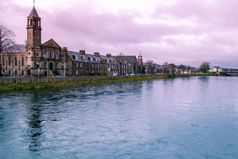
Inverness is a compact, walkable city with a strong sense of place and a surprisingly relaxed atmosphere. It works equally well as a short stay, a first-night stop, or a base for exploring the surrounding area.
What to See and Do
Inverness Castle (exterior & viewpoint) – Overlooking the River Ness, the castle hill offers excellent views across the city and surrounding countryside.
Old Town of Inverness & Victorian Market – Small streets, local shops, cafés and traditional pubs in the historic heart of the city.
St. Andrew's Cathedral – A striking Gothic Revival cathedral beside the river.
Riverside & Ness Islands – Peaceful walking routes along the River Ness and through wooded islands linked by footbridges.
Inverness Museum & Art Gallery – Good introduction to Highland history, archaeology and culture.
Caledonian Canal– Walk or cycle along the towpath, or watch boats pass through the locks at Dochgarroch.
Inverness Botanic Gardens – A small but pleasant stop, especially if you want something relaxed and easy.
Whisky Distillery Visits (nearby) – Options such as Singleton Distillery or The Tomatin Distillery Visitor Centre offer classic Highland distillery tours.
Dolphin Watching (Inner Moray Firth) – Boat trips and shoreline viewing for the famous bottlenose dolphins. Exploring the Inner Moray Firth with Dolphin Spirit
Highland Archive Centre - Explore historical records and resources related to the Highlands and Islands of Scotland.
-
Start/End: Inverness Castle Viewpoint
Duration: ~2 hours
Distance: ~2.5–3 km
Pace: Leisurely with photo and short viewing stops
Highlights: Castle views, riverside walk, cathedral, historic Old Town, and the Ness Islands.1. Inverness Castle Viewpoint (Start Point)
Start at the Castle Viewpoint Terrace for sweeping views over the River Ness and city rooftops.
Though the castle itself is currently under redevelopment, the exterior and viewpoint remain impressive.
Optional: Small fee to access the viewing platform if open.
Time here: 10 mins
2. Castle Street & Old High Street
Walk down Castle Street into the heart of the Old Town.
Pass by Inverness Town House, a striking Gothic Revival civic building.
Turn onto Church Street, one of the city’s oldest, lined with historic architecture and local shops.
Time here: 10–15 mins
3. Old High Church & Church StreetStop at the Old High Church (St Stephen’s), said to stand on the site of a Celtic church and used during the Jacobite period.
The graveyard is evocative and peaceful, offering a moment of reflection and local history.
Time here: 10 mins
4. Inverness Cathedral (St Andrew’s)Cross the pedestrian Greig Street Bridge to reach the Cathedral, the northernmost in mainland Britain.
Marvel at its red sandstone architecture and twin towers. Free to enter and explore the interior if time permits.
Time here: 10–15 mins
5. River Ness Riverside Walk
Follow the riverside path southwards along the tree-lined promenade.
Peaceful walking route with benches, views of local birdlife, and distant glimpses of the castle and hills.
Time here: 10 mins walking
6. Ness IslandsCross via one of the small suspension bridges onto the Ness Islands – a chain of wooded river islets.
The paths are flat and shaded, great for quiet walking or a short pause among nature.
Time here: 15–20 mins
7. Back to the Castle via Bishops RoadWalk back along the east side of the river, past Eden Court Theatre and the Cathedral again.
Ascend Bishops Road to return to the castle viewpoint or the town centre.
Time here: 15 mins walk
Optional Stops (If Time Allows)
Victorian Market: Covered shopping arcade with independent shops and a great local vibe.
Inverness Museum & Art Gallery: Located near the castle, worth a quick 10–15 min browse.
Leakey’s Bookshop: Iconic second-hand bookshop in a converted church on Church Street.
-
Getting Around
Inverness is compact and easy to explore on foot, especially around the river, Old Town and castle area.
Parking
Rose Street Car Park (central, multi-storey)
Eastgate Centre Car Park
Old Town Rose Street / Chapel Street area
Longer-stay options around the edges of the centre
Park and Ride
Inverness has Park and Ride sites on the outskirts of the city, which are useful if you don’t want to drive into the centre:
Inshes Park and Ride (east side, near A9)
Longman Park and Ride (north side)
These are especially useful in busy seasons.
Good to Know
The city is a good place to stock up on supplies before heading north.
Fuel, supermarkets, outdoor shops and pharmacies are all easy to find here.
Experiences In and Around Inverness
Trips from Inverness
Loch Ness & the Great Glen

No visit to Inverness is complete without venturing into the Great Glen and along the shores of Loch Ness — one of Scotland’s most famous and dramatic landscapes.
Stretching for 23 miles (37 km) and reaching depths of over 230 metres, Loch Ness is the largest freshwater loch in Scotland by volume. While its global fame comes from the legend of “Nessie”, the real appeal lies in the scale of the landscape: steep wooded slopes, long empty waters, ruined castles and ever-changing light.
This is also one of Scotland’s great natural corridors, shaped by ancient geological forces and later used for roads, canals and military routes.
Key Places Along Loch Ness
Urquhart Castle (see below) – Dramatically positioned on a rocky promontory above the loch; one of the most atmospheric castle ruins in Scotland.
Loch Ness Shores & Viewpoints – Numerous lay-bys and short walks along the A82 and quieter side roads.
Boat Trips on Loch Ness – Several operators run cruises from different points along the loch.
-
The mystery of Nessie dates back centuries, with early references appearing in ancient Scottish folklore. One of the oldest recorded accounts comes from the 6th century, when Saint Columba, an Irish missionary, is said to have encountered a mysterious beast in the River Ness. However, the modern legend gained significant attention in 1933, when a couple claimed to have seen a large, unknown creature crossing the road near the loch. This sighting sparked global curiosity, leading to numerous investigations, expeditions, and sonar studies attempting to uncover the truth behind the myth.
-
1. Discover the Legend at the Loch Ness Centre
Located in Drumnadrochit, The Loch Ness Centre is the perfect place to delve into the history, geology, and mystery of the loch.
The interactive exhibits explore the scientific investigations into Nessie, the natural history of Loch Ness, and the various hoaxes and photographs that have fueled the legend.
A visit here provides an engaging introduction before exploring the loch itself.
2. Explore Urquhart Castle
Urquhart Castle, perched on the western shore of Loch Ness, is one of Scotland’s most iconic medieval fortresses.
Dating back to the 13th century, the castle played a significant role in the Wars of Scottish Independence and was later destroyed to prevent it from falling into Jacobite hands.
Visitors can explore the ruined towers, great hall, and defensive walls, while enjoying breathtaking views of the loch from the Grant Tower.
The castle is managed by Historic Scotland, with an on-site visitor centre and café.
3. Take a Boat Cruise on Loch Ness
Several tour companies operate boat cruises on Loch Ness, offering a unique perspective of the vast waters and the surrounding landscape.
Many tours depart from Inverness, Drumnadrochit, and Fort Augustus. Some feature sonar scans of the loch, adding to the thrill of searching for Nessie.
Recommended operators:
Jacobite Cruises (departing from Inverness)
Cruise Loch Ness (Fort Augustus)
Loch Ness by Jacobite (Drumnadrochit)
4. Enjoy Outdoor Activities on the Loch
Kayaking and Paddleboarding: Several rental companies offer guided kayak and paddleboarding experiences, allowing visitors to enjoy the tranquil waters of the loch up close.
Wild Swimming: While the water remains cold year-round, wild swimming is an option for adventurous visitors (with caution due to the depth and temperature).
5. Walk the Scenic Trails Around Loch Ness
The Great Glen Way follows the northern shore of Loch Ness, offering stunning viewpoints along the way.
South Loch Ness Trail is a quieter alternative, running along the less-visited southern side of the loch.
Other notable walks include:
Divach Falls Trail – A short woodland walk leading to a scenic waterfall near Drumnadrochit.
Invermoriston Bridge and Falls – A beautiful spot for a short walk and photo opportunity.
6. Visit Charming Villages and Towns
Drumnadrochit – A lively village known as the gateway to Loch Ness, home to The Loch Ness Centre and several Nessie-themed attractions.
Fort Augustus – Located at the southern tip of the loch, this picturesque town features canal locks on the Caledonian Canal, riverside walks, and Cruise Loch Ness tours.
Invermoriston – A small, peaceful village known for the Invermoriston Falls and Old Telford Bridge.
7. Take a Scenic Drive Along the Loch
The A82 road runs along the northern shore of Loch Ness, offering some of Scotland’s most scenic driving routes.
There are several viewpoints and picnic spots along the way, making it ideal for road trips and photography.
The quieter southern route along the B852 provides a more remote and less touristy experience.
-
Location and Accessibility
Distance from Inverness: ~14 miles (23 km) southwest
By Car:
Loch Ness is easily accessible from Inverness via the A82. The drive to Drumnadrochit takes about 25 minutes, and to Fort Augustus about 50 minutes.
There are multiple parking areas at visitor attractions such as Urquhart Castle, Fort Augustus, and Drumnadrochit.
By Bus:
Buses run between Inverness and Fort Augustus, stopping at Drumnadrochit and Urquhart Castle.
Services are operated by Stagecoach and Citylink.
By Boat:
Some Loch Ness cruises depart directly from Inverness, combining transport with a scenic tour.
Urquhart Castle
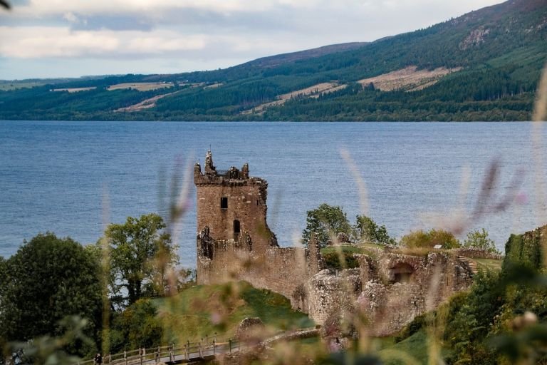
Standing on a rocky promontory overlooking Loch Ness, Urquhart Castle is one of Scotland’s most iconic medieval fortresses. Once a mighty stronghold, the castle played a pivotal role in Scotland’s turbulent history, witnessing centuries of clan battles, wars of independence, and Jacobite conflicts. Though now a ruin, it remains a powerful symbol of the Highlands’ resilience and offers visitors stunning views, rich history, and a connection to Scotland’s past. Whether approached by land or boat, Urquhart Castle is a must-visit destination for anyone exploring Loch Ness and the Scottish Highlands.
-
Perched on the western shore of Loch Ness, Urquhart Castle is one of Scotland’s most dramatic and historically significant fortresses. Though now a picturesque ruin, the castle has a rich history filled with battles, sieges, and power struggles that shaped the Highlands.
The site has been occupied for over 1,500 years, with evidence suggesting a Pictish fort once stood here. However, Urquhart Castle as we know it was built in the 13th century, becoming a key stronghold during the medieval Wars of Scottish Independence. Over the centuries, the castle played a vital role in conflicts between the Scots and English, as well as the clan feuds of the Highlands.
Some of its most significant historical moments include:
The Wars of Scottish Independence (13th–14th Century) – The castle was captured and held by English forces under Edward I but later retaken by Robert the Bruce in 1307.
The Clan MacDonald Raids (15th Century) – The castle was frequently attacked by the MacDonalds of the Isles, earning it a reputation as one of the most fought-over castles in Scotland.
The Jacobite Era and its Destruction (17th Century) – In 1692, government forces blew up the castle to prevent its use by Jacobite rebels. This act left Urquhart in ruins, and it was never rebuilt.
Today, the ruins of Urquhart Castle remain an iconic symbol of Highland resilience and provide visitors with breathtaking views of Loch Ness.
-
1. Explore the Castle Ruins
Walk through the Great Hall, where medieval banquets were once held.
Climb the Grant Tower, the tallest surviving structure, for panoramic views of Loch Ness.
See the remains of a medieval prison cell, once used to hold enemy warriors and prisoners.
Discover the former chapel and gatehouse, which offer insights into daily life in the castle.
2. Enjoy Stunning Views of Loch Ness
The castle is one of the best viewpoints for taking in the vastness of Loch Ness.
Visit in the early morning or late afternoon for the most atmospheric lighting.
3. Learn the Castle’s History at the Visitor Centre
Watch a short film about Urquhart Castle’s turbulent history.
See artifacts discovered at the site, including medieval weapons and pottery.
Browse the gift shop, which offers Highland souvenirs and history books.
4. Take a Loch Ness Boat Tour to the Castle
Several boat companies operate cruises that stop at Urquhart Castle, offering a unique approach from the water.
Popular operators include:
Jacobite Cruises (departing from Inverness)
Cruise Loch Ness (from Fort Augustus)
5. Picnic with a View
The castle grounds offer scenic picnic areas overlooking Loch Ness, perfect for a break during your visit.
-
Location and Accessibility
Address: Urquhart Castle, Drumnadrochit, Inverness IV63 6XJ, Scotland
Distance from Inverness: ~21 km (~13 miles) southwest
Time Required: ~1.5 to 2 hours for a full visit
Getting There
By Car:
Follow the A82 south from Inverness (about a 30-minute drive).
Free on-site parking is available.
By Bus:
Stagecoach Bus 919 runs between Inverness and Fort Augustus, stopping at Urquhart Castle.
By Boat:
Jacobite Cruises and other operators offer tours that include a boat trip across Loch Ness with a stop at the castle.
Opening Hours and Entry Fees
Opening Hours:
April – September: 9:30 AM – 6:00 PM
October – March: 10:00 AM – 4:00 PM
Closed December 25 & 26, January 1 & 2
Entry Fees:
Adults: ~£14
Children (5-15): ~£8.50
Free for Historic Scotland members
Nearby: Around Inverness and the Great Glen
The landscape around Inverness is one of the most historically rich parts of the Highlands. Within a short drive of the city and Loch Ness, you can explore battlefields, prehistoric monuments, great fortresses and aristocratic houses that together tell the story of Scotland from the Bronze Age to the Jacobite era and beyond.
These places are not just “nearby stops” — they form the historical and cultural hinterland of Inverness and the Great Glen. Visiting even one or two adds real depth and context to the start of your journey north, helping you understand both the ancient roots and the more turbulent recent history of the Highlands.
All of the following can be easily visited as short half-day or day-trip excursions from Inverness or as natural stops before continuing further north.
Culloden Battlefield & Visitor Centre (see below) – The site of the final Jacobite battle in 1746.
Clava Cairns (see below) – A remarkable Bronze Age burial complex aligned to the winter solstice.
Fort George – An immense 18th-century military fortress overlooking the Moray Firth.
Brodie Castle – A historic castle and estate with strong Jacobite connections and fine gardens.
How to Combine These Sites into a Great Day Out
If you’d like to visit more than one of these places, they fit together naturally into a very rewarding day out from Inverness.
A good way to do it is to start with Clava Cairns, just outside the city. It’s a quiet, atmospheric introduction to the deep past of the Highlands, dating back over 4,000 years. From here, it’s a short drive to Culloden Battlefield and Visitor Centre, where the story jumps forward to the dramatic events of 1746.
From Culloden, continue east towards the Moray Firth to Fort George, a vast 18th-century fortress built in the aftermath of the Jacobite rising. If you still have time, finish at Brodie Castle, which makes a lighter and more relaxed final stop with its gardens and café.
Taken together, this route follows both the landscape and the historical timeline, and works well as a full day out or split into two shorter half-day trips.
The Jacobite Risings and the Battle of Culloden
-
The Jacobite Risings were a series of uprisings in the 17th and 18th centuries, driven by the goal of restoring the House of Stuart to the British throne. Rooted in political, religious, and dynastic conflicts, these rebellions were largely supported by Highland clans and loyalists who opposed the ruling Hanoverian monarchy. The movement took its name from the Latin for James—*"Jacobus"—*in reference to James II and his descendants, whom the Jacobites sought to reinstate as rightful rulers.
The most well-known of these uprisings was the Jacobite Rising of 1745, led by Charles Edward Stuart, better known as Bonnie Prince Charlie. The rebellion saw Jacobite forces advancing as far south as Derby before retreating northward, ultimately culminating in the Battle of Culloden on April 16, 1746. This final, brutal confrontation, fought on Drumossie Moor near Inverness, resulted in a crushing defeat for the Jacobites at the hands of the Duke of Cumberland’s government army. It marked the definitive end of the Jacobite cause, leading to harsh reprisals, the dismantling of Highland clan structures, and the suppression of Gaelic culture.
-
Visiting Culloden Battlefield and Visitor Centre
Overview
Culloden Battlefield is one of Scotland’s most historically significant sites. It was here, on April 16, 1746, that the final and most decisive battle of the Jacobite Risings took place. The clash between Bonnie Prince Charlie’s Jacobite army and the government forces led by the Duke of Cumberland resulted in a swift and devastating defeat for the Jacobites. This battle effectively ended the Jacobite cause, led to harsh reprisals against Highland culture, and changed Scotland’s history forever.
Today, the battlefield is preserved by the National Trust for Scotland and includes a Visitor Centre, offering an in-depth look at the events leading up to the battle, the key figures involved, and the wider impact on Scotland’s history.
How to Get There
Location: Culloden Moor, Inverness IV2 5EU, Scotland
Distance from Inverness: ~5 miles east
Transport Options:By Car: 15-minute drive from Inverness, with free parking available.
By Bus: Bus 5A from Inverness city centre stops near the battlefield.
By Taxi: A taxi ride from Inverness costs approximately £15–£20.
What to See and Do
Culloden Visitor Centre
Exhibits: Interactive displays, original weapons, personal letters, and artifacts from both Jacobite and government soldiers.
Battle Experience Room: A 360-degree immersive film places visitors in the middle of the battle.
Timeline Galleries: Dual perspectives allow visitors to follow the campaign from both Jacobite and government viewpoints.
Cafe and Gift Shop: Offers local produce and souvenirs related to Scottish history and the Jacobite era.
The Battlefield
Marked Graves: Stone markers indicate the mass graves of fallen Jacobite soldiers, grouped by clan.
Memorial Cairn: A 20-foot stone monument erected in 1881 to honor the Jacobites.
Government Redoubt: A defensive position built by government forces.
Culloden Cottage: A historic building used as a field hospital after the battle.
Battlefield Walks: Guided tours are available, or visitors can explore at their own pace using the Culloden Battlefield Trail.
When to Visit
Opening Hours: Typically 10:00 AM – 4:00 PM (hours vary seasonally).
Best Time to Visit: Spring and summer for clearer weather, though autumn and winter offer a more atmospheric experience.
Special Events: Anniversary events in April often include reenactments and special talks.
Tips for Visitors
Allow 2-3 hours to fully explore the site and visitor centre.
Wear sturdy footwear, as the battlefield trails can be uneven and muddy.
Check the weather, as Culloden Moor is exposed and can be windy.
Join a guided tour for deeper insights into the battlefield’s history.
Visit nearby Clava Cairns, a prehistoric site just a short drive from Culloden.
-
Culloden Battlefield & Visitor Centre
Location: ~5 miles east of Inverness
Why Visit?
The site of the Battle of Culloden is one of Scotland’s most significant historical locations. Today, it is managed by the National Trust for Scotland, offering a preserved battlefield with markers indicating the positions of Jacobite and government forces. The Culloden Battlefield and Visitor Centre provides an immersive experience with artifacts, interactive displays, and an audio-visual recreation of the battle. Visitors can walk the battlefield trails and reflect on the pivotal moment that ended the Jacobite dream.
Glenfinnan Monument & Viaduct
Location: Glenfinnan, on the shores of Loch Shiel
Why Visit?
Glenfinnan is where Bonnie Prince Charlie first raised the Jacobite standard on August 19, 1745, marking the beginning of the Rising. The Glenfinnan Monument, erected in 1815, stands as a tribute to the fallen Jacobite clansmen. The site offers stunning views across Loch Shiel and is also famous for the Glenfinnan Viaduct, an iconic railway bridge known from the Harry Potter films.
The Jacobite Trail
Why Visit?
The The Jacobite Trail is a self-guided route connecting key locations from the 1745 Rising. Significant stops include:Ruthven Barracks – A government stronghold burned by the Jacobites after Culloden.
Dalwhinnie – A strategic route used during the Jacobite march south.
Falkirk Muir – The site of a Jacobite victory before their retreat.
This route allows visitors to follow in the footsteps of the Jacobites and explore the landscapes that shaped their campaign.
Urquhart Castle
Location: Loch Ness, ~30 minutes southwest of Inverness
Why Visit?
Though not directly linked to the 1745 Rising, Urquhart Castle played a role in earlier Jacobite conflicts. This medieval fortress was a key defensive stronghold on Loch Ness and was seized by government forces during the 1715 Jacobite Rising before being deliberately destroyed to prevent its use by rebels. The castle ruins, set against the backdrop of Loch Ness, offer a glimpse into Scotland’s turbulent past.
Ruthven Barracks
Location: Near Kingussie, ~45 miles south of Inverness
Why Visit?
Ruthven Barracks was a government garrison built after the 1715 Jacobite Rising to maintain order in the Highlands. It played a role in the 1745 campaign when it was seized by Jacobite forces. After Culloden, it became a rallying point for fleeing Jacobites before the final disbanding of their forces. Today, the ruins remain a stark reminder of the military resistance to the Jacobite cause.
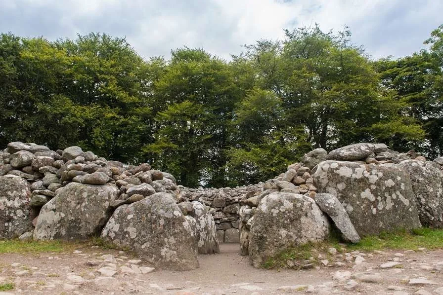
Clava Cairns - Bronze Age Burial Landscape
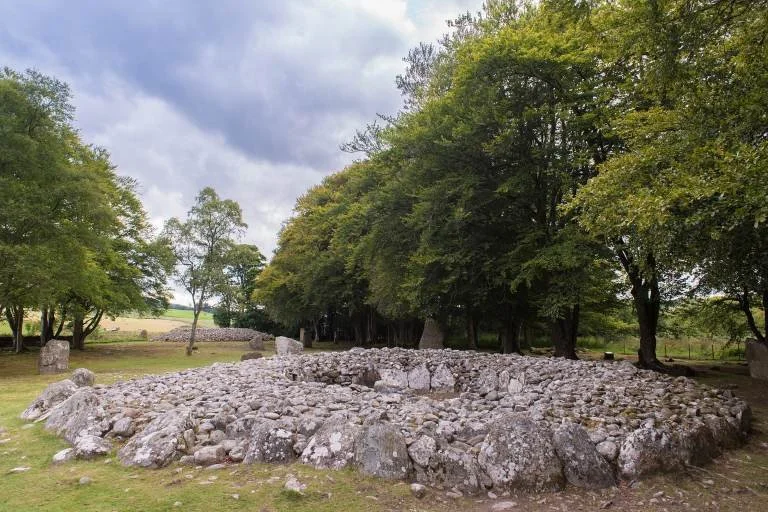
Nestled in the tranquil countryside just a few miles from Culloden Battlefield, the Clava Cairns stand as a remarkable testament to Scotland’s prehistoric heritage. Dating back around 4,000 years to the Bronze Age, these well-preserved burial cairns offer a glimpse into the rituals, beliefs, and astronomical knowledge of early Highland societies. Surrounded by standing stones and aligned with the winter solstice, Clava Cairns is more than just an archaeological site—it is a place of mystery, reflection, and historical intrigue. Whether you are drawn by its ancient significance, connections to folklore, or its inspiration for Outlander, visiting Clava Cairns is a unique experience that transports you deep into Scotland’s past.
-
The Clava Cairns, also known as the Prehistoric Burial Cairns of Balnuaran, are an exceptionally well-preserved Bronze Age burial site, dating back approximately 4,000 years. Located just a few miles southeast of Culloden Battlefield, the site provides a fascinating glimpse into Scotland’s ancient past and is considered one of the most significant archaeological sites in the Highlands.
This complex consists of three distinct burial cairns, each encircled by standing stones. The cairns were constructed using large stone slabs and were likely used for both burial and ceremonial purposes by the prehistoric communities that inhabited the region.
One of the most intriguing aspects of the Clava Cairns is their precise alignment with the winter solstice. The entrance passages of the cairns face the setting sun on the shortest day of the year, indicating that the site may have played an important role in solar rituals and seasonal ceremonies. This alignment suggests that the ancient builders had a deep understanding of astronomy and the cycles of nature, much like the builders of Stonehenge in England.
The Clava Cairns are also believed to have inspired Craigh na Dun, the fictional standing stones in Outlander, drawing fans of the series to the site.
-
1. Explore the Burial Cairns
Walk among the three large burial cairns, each featuring an internal chambered tomb.
Notice the different styles of cairns—two have passage graves (aligned with the solstice), while the third is a ring cairn without an entrance.
2. Discover the Stone Circles
Surrounding each cairn are standing stones, some of which may have had ceremonial or astronomical significance.
The stones are set in a peaceful wooded landscape, enhancing the site’s mysterious atmosphere.
3. Learn About Ancient Rituals and Traditions
Imagine how prehistoric people may have used the site for funerary rituals, ancestor worship, and celestial observations.
The site is believed to have been in use for centuries, with later Pictish and medieval peoples possibly reusing the stones for their own purposes.
4. Enjoy a Quiet, Reflective Visit
Unlike more tourist-heavy sites, Clava Cairns offers a tranquil and atmospheric experience where visitors can absorb the mystery of this ancient landscape.
-
Location and Accessibility
Address: Balnuaran of Clava, Inverness IV2 5EU, Scotland
Distance from Inverness: ~6 miles southeast
Distance from Culloden Battlefield: ~1.5 miles (a short drive or 30-minute walk)
Getting There
By Car:
A 15-minute drive from Inverness via the B9006.
A small car park is available on-site.
By Bus:
No direct bus service, but Bus 5A from Inverness stops near Culloden Battlefield. From there, you can walk or take a taxi.
By Taxi:
A taxi from Inverness costs around £15–£20 and takes about 15 minutes.
By Walking:
If visiting Culloden Battlefield, you can walk to Clava Cairns via a scenic country path (around 30 minutes).
Opening Hours and Entry Fees
Opening Hours: Open year-round, 24/7.
Entry Fees: Free (managed by Historic Environment Scotland).
Best Time to Visit
Winter Solstice (December 21st): A unique time to visit when the site aligns with the setting sun.
Spring and Summer: Longer daylight hours and lush greenery enhance the beauty of the site.
Autumn: A peaceful time with fewer visitors and golden foliage.
The Black Isle Peninsula
Optional Coastal Loop of Dolphins, Picts and Sheltered Shores - How This Fits Into Your Journey
While the main route north continues straight up the A9 from Inverness, many travellers choose to begin their coastal journey with a loop around the Black Isle Peninsula — a fertile and surprisingly mild stretch of land lying between the Moray Firth and the Cromarty Firth.
This optional loop adds half a day to a full day to your trip and starts just after crossing the Kessock Bridge from Inverness. It then circles the peninsula’s coastline before rejoining the main northbound route at Dingwall.
It is an ideal way to ease into the coastal landscapes of the north: gentler, greener and more settled than what comes later, but rich in wildlife, history and beautiful views.
The Black Isle
Despite its name, the Black Isle is not an island but a scenic peninsula between two great firths. It offers a wonderful mix of historic villages, sheltered coastline, wildlife watching and wide sea views.
This is one of the best places in Scotland to see bottlenose dolphins from shore, as well as explore Pictish heritage, small harbours and quiet beaches. It feels very different from the wilder landscapes further north, which is exactly why it works so well at the start of the journey.
Driving Route Overview
Total Distance: ~50 miles (80 km)
Driving Time: ~2 hours (without stops)
Recommended Time: Half-day to full day with stops
Route: Inverness → North Kessock → Fortrose & Rosemarkie → Chanonry Point → Cromarty → Jemimaville & Udale Bay → Dingwall → Continue north on A9
What to See and Do Along the Route
1. North Kessock – Gateway to the Black Isle - Just across the Kessock Bridge from Inverness, this small village marks the start of the loop and offers fine views across the Beauly Firth.
North Kessock Dolphin Viewing Point – One of the best land-based spots to see bottlenose dolphins.
A good place to pause and look back towards Inverness before heading further along the coast.
2. Fortrose & Rosemarkie – Historic Towns and Beachfront - These neighbouring towns sit on a beautiful stretch of coast overlooking the Moray Firth.
Fortrose Cathedral – A striking 13th-century red sandstone ruin in the heart of Fortrose.
Rosemarkie Beach – A lovely sandy beach, perfect for a quick stroll or a picnic.
Groam House Museum – A small but fascinating museum showcasing Pictish stones and carvings.
3. Chanonry Point – One of Scotland’s Best Dolphin Spots - Chanonry Point is famous for offering some of the best dolphin watching from land anywhere in the UK.
Dolphins are often seen at rising tide, when they come close to shore to feed.
Lighthouse, wide views across the Moray Firth and frequent wildlife sightings.
Boat trips also operate from nearby, including Ecoventures.
For the adventurous, Learnie Red Rocks mountain bike trails lie just east of the road before Cromarty.
4. Cromarty – A Seaside Village with Historic Charm - At the eastern tip of the peninsula, Cromarty is one of the most beautiful historic villages in the Highlands.
Cromarty Courthouse Museum – Local maritime and social history.
Hugh Miller’s Birthplace Museum – Celebrates the life of the famous geologist and writer.
Cromarty Harbour – Walk along the waterfront with views across the firth, where historic buildings sit alongside modern industry.
A seasonal ferry to Nigg operates from Cromarty if you want to extend your exploring.
5. Jemimaville & Udale Bay – Wildlife and Open Coast
Leaving Cromarty, the road follows the quieter side of the peninsula along the Cromarty Firth.
Udale Bay Nature Reserve – Excellent for seabirds and wading birds, especially in spring and autumn.
Long, peaceful coastal views and a strong sense of space, particularly at sunset.
6. Dingwall – A Highland Market Town
Dingwall marks the point where the Black Isle loop rejoins the main northbound route.
Shops, cafés and services if you need a break or supplies.
Dingwall Museum – Covers the town’s Viking and Highland history.
From here, continue north on the A9 towards Dornoch, Dunrobin Castle and the far north.
Optional Short Detour: Fairy Glen Falls
If you have extra time, a short detour from Rosemarkie leads to Fairy Glen Falls, a pleasant woodland walk with small waterfalls and pools, tied to local legends.
Why It’s Worth Doing
The Black Isle offers:
One of the best chances to see dolphins anywhere in Scotland
A gentle, scenic coastal introduction to the journey
A mix of wildlife, history and easy walking
A complete contrast to the much wilder landscapes that lie further north
From the Black Isle to the Far North
Leaving the Black Isle behind at Dingwall, the route returns to the main northbound line and begins to follow the long, curving shores of the Moray Firth. The land here still feels relatively gentle and open, but there is a clear sense that you are moving into a different Scotland — one that is broader, quieter and steadily more exposed to the sea and sky.
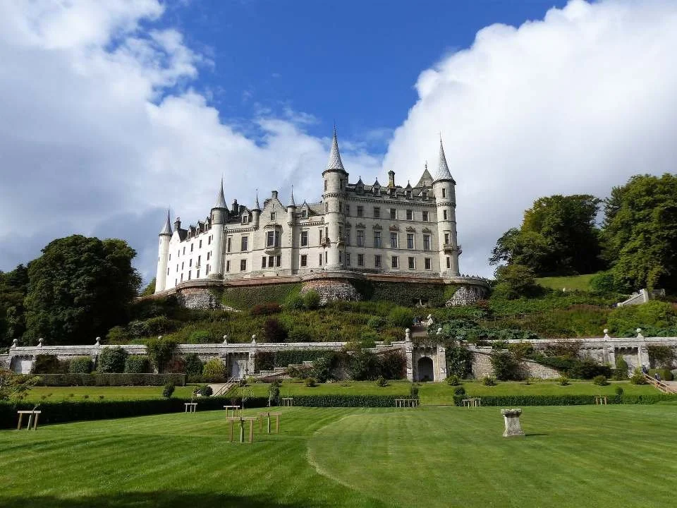
For a while, the road runs through wide farmland and along sheltered waters, with long views across the firth and the distant outline of hills ahead. Then, almost unexpectedly, one of the great landmarks of northern Scotland appears above the coast: Dunrobin Castle.
With its fairytale turrets and formal gardens, Dunrobin feels like the last great aristocratic statement of the northern Highlands. It stands at a natural threshold in the journey: behind you lie the more settled landscapes of the inner firths; ahead lies the far north, where the coast becomes rockier, the skies bigger, and the land older and more elemental.
Beyond Dunrobin, the character of the journey changes. The road begins to feel more exposed, settlements grow smaller and further apart, and the landscape starts to take on the raw, archaeological feel of Caithness. Cliffs, harbours, prehistoric sites and long stretches of open coast begin to define the days ahead, as the route pushes on towards Dunbeath, Lybster and Wick and the heart of the northern coast.
Dunrobin Castle – The Threshold of the Northern Highlands
Perched on the edge of the Dornoch Firth, Dunrobin Castle is one of Scotland’s most striking and elegant stately homes. Located near the village of Golspie, the castle’s French château-style turrets, grand façade, and immaculately landscaped gardens create a fairytale-like setting that stands in stark contrast to the rugged Highland landscape surrounding it. With 189 rooms, Dunrobin is not only one of Scotland’s largest castles, but also one of its most historically significant, serving as the ancestral seat of the Earls and Dukes of Sutherland. Whether exploring its sumptuous interiors, strolling through its Versailles-inspired gardens, or witnessing a spectacular falconry display, a visit to Dunrobin Castle is a journey into Scotland’s aristocratic past and architectural grandeur.
-
The origins of Dunrobin Castle date back to the 13th century, making it one of the oldest continuously inhabited houses in Scotland. Initially built as a medieval stronghold, it evolved over centuries from a fortified tower house into a luxurious stately home.
Throughout its history, the castle has been closely tied to the Clan Sutherland, one of the most powerful noble families in Scotland. The Sutherlands played a significant role in Scottish politics, landownership, and the Highland Clearances, during which many tenant farmers were displaced to make way for sheep farming.
The most dramatic transformation of Dunrobin Castle took place in the mid-19th century, when it was redesigned by Sir Charles Barry, the architect of London’s Houses of Parliament. Barry's redesign gave the castle its distinctive French château appearance, with its soaring spires, pointed towers, and elaborate stonework, inspired by European Renaissance palaces.
During World War I, the castle briefly functioned as a military hospital, before being restored to its former grandeur. Today, Dunrobin remains a privately owned residence, but is open to the public, offering a glimpse into its fascinating history, lavish interiors, and breathtaking gardens.
-
1. Explore the Grand Interiors
Walk through lavish state rooms, adorned with fine furniture, oil paintings, and ornate chandeliers.
Visit the drawing room, dining room, and library, each reflecting the elegance of Victorian aristocracy.
Discover the castle’s extensive collection of historical artefacts, including military memorabilia, weapons, and rare books.
2. Stroll Through the Versailles-Inspired Gardens
Designed in the French formal style, the manicured gardens were modelled after those of the Palace of Versailles.
Enjoy ornamental ponds, sculpted hedges, fountains, and vibrant flower beds.
Take in stunning views over the Dornoch Firth, particularly in the summer when the gardens are in full bloom.
3. Watch a Falconry Display
Dunrobin Castle hosts daily falconry demonstrations, where expert falconers showcase the skills of hawks, falcons, and owls.
These displays take place in the gardens, offering a unique experience reminiscent of traditional aristocratic hunting practices.
4. Visit the Castle Museum
Located in a former summer house, the museum houses an eclectic collection of hunting trophies, Pictish stones, and archaeological relics.
See taxidermy exhibits, antique weaponry, and artefacts related to the Sutherland family’s history.
5. Walk Along the Coastal Path
A scenic coastal walk near the castle offers spectacular views of the North Sea, with opportunities to spot seals, seabirds, and other wildlife.
-
Location and Accessibility
Address: Dunrobin Castle, Golspie, Sutherland, KW10 6SF, Scotland
Distance from Inverness: ~50 miles (80 km) northeast (~1 hour 15 minutes by car)
Distance from Urquhart Castle: ~85 miles (137 km) northeast (~2 hours by car)
Getting There
By Car: The castle is located just off the A9, making it easily accessible from Inverness, Dornoch, and further north.
By Train: The Dunrobin Castle railway station, located a short walk from the castle, is on the Far North Line, connecting Inverness to Thurso and Wick.
By Bus: Stagecoach buses run between Inverness and Golspie, with stops near the castle.
Opening Hours and Entry Fees
Open: Typically from April to October, but dates may vary.
Hours: 10:00 AM – 5:00 PM (last entry at 4:30 PM).
Entry Fees: Around £14 for adults, £8.50 for children (check the official website for updated prices).
Best Time to Visit
Spring and Summer (April–August): Best for garden visits and falconry shows.
Autumn (September–October): Fewer crowds, with stunning seasonal colours.
Winter: The castle is typically closed to the public, but the surrounding landscape remains breathtaking.
From Dunrobin to Dunbeath: The Sutherland Coast
Leaving the elegance of Dunrobin Castle behind, the journey changes character almost immediately. The coast becomes more exposed, the land feels broader and quieter, and the story of the Highlands shifts from aristocratic estates to something older, harsher and more elemental.
This stretch of the Sutherland coast is one of the most haunting and historically layered parts of the entire east coast. Here you’ll find Iron Age brochs, abandoned clearance villages, ruined castles and long, empty beaches facing the North Sea. It is a landscape shaped as much by loss and survival as by geology and weather.
Although this is not a long drive, it rewards a slow pace and frequent stops. Each headland, harbour and ruin adds another chapter to the story of how people have lived — and sometimes failed to live — on this demanding coastline.
Brora & the Open Coast
Brora Beach - Brora’s wide, golden beach is one of the most beautiful stretches of sand on this coast. Backed by dunes and scattered with Jurassic rocks, it runs for around two miles and feels open, bright and exposed to the North Sea. This is a good place to pause, stretch your legs and watch the sea. Dolphins, minke whales, and grey and common seals are sometimes seen offshore, especially in calm weather.
Crakaig Beach - A few miles north of Brora, Crakaig Beach is another fine sandy stretch of coast. Part of the beach is designated as a naturist beach, though there is plenty of space for everyone to enjoy the shoreline and wide coastal views.
The Wolf Stone - Near this part of the coast stands the Wolf Stone, marking the place where, according to tradition, the last wolf in Sutherland was killed around 1700. It is a small but evocative reminder of how different and wilder this landscape once was.
Helmsdale & the Story of the Clearances
Helmsdale Castle Monument - At Helmsdale, a monument marks the site of a castle originally built in 1488. The castle fell into ruin in the 19th century and was eventually removed entirely to make way for the road and bridge, but the monument preserves its memory and strategic importance.
Badbea Clearance Village - A short distance from Helmsdale lies Badbea, one of the most powerful and moving sites on this coast. Here, on a steep, exposed cliff top, you can still see the remains of stone houses from a village created during the Highland Clearances. Life here was brutally hard, and the village was eventually abandoned. Today, the ruins and the empty landscape around them tell a stark story of displacement, endurance and loss. There is a small car park and a short walk to the site.
The Ancient North: Brochs and Early Settlements
Cairn Liath Broch - Cairn Liath is an Iron Age broch standing close to the coast. Brochs are a uniquely Scottish type of drystone fortification, and this ruin gives a fascinating insight into the ingenuity and defensive priorities of Iron Age communities.
Ousdale Broch - Located between Helmsdale and Berriedale, Ousdale Broch is another impressive example of this ancient building tradition. Seen together, these sites show just how long people have been living and defending this coastline.
Ruined Strongholds
Berriedale Castle - Near the mouth of the Berriedale Water stand the ruins of Berriedale Castle, a 14th-century stronghold once held by Sir Reginald Cheyne. Though now heavily ruined, its position overlooking the river and coast shows how strategically important this narrow coastal corridor once was.
Onwards into Caithness
Beyond Berriedale, the route crosses into Caithness and the landscape begins to open out even further. The cliffs, harbours and ancient sites continue, but the scale becomes bigger, the horizons wider, and the feeling of the far north stronger — as the journey continues towards Dunbeath, Lybster and Wick.
The Caithness Coast - Cliffs, Harbours and the Ancient North
Beyond Dunbeath, the route enters Caithness and the landscape opens out into a broad, windswept coast of big skies and long horizons. Where the previous stretch feels like a threshold, this feels like arrival: a simpler, more exposed land shaped by the North Sea.
This is one of the most archaeologically rich parts of northern Scotland. Brochs, cairns, ruined castles and old harbours sit close to the road, telling a story that stretches from the Iron Age through the herring boom of the 19th century to the present day. Towns like Lybster and Wick still carry the marks of that maritime past.
This section follows the coast through Dunbeath, Lybster and Wick, a landscape that rewards a slow pace, frequent stops, and time spent away from the car before the journey continues towards John O’Groats and the far north.
Dunbeath – Gateway to Caithness
Nestled on the east coast of Caithness, Dunbeath is a small but historically rich village in the Scottish Highlands, located along the A9 road, approximately midway between Helmsdale and Wick. Known for its rugged coastal scenery, deep historical roots, and literary connections, Dunbeath offers visitors a glimpse into Scotland’s ancient past, Viking heritage, and Highland traditions.
Surrounded by rolling hills, cliffs, and the North Sea, Dunbeath has long been a fishing and agricultural settlement, shaped by the changing tides of Highland history. While today it is a quiet and picturesque village, its past tells a story of prehistoric settlements, medieval power struggles, and 19th-century industrial growth, making it an intriguing stop for those exploring Scotland’s northeast coast.
-
Prehistoric and Early Settlements
The Dunbeath area has been inhabited for thousands of years, with traces of prehistoric settlements, cairns, and brochs scattered across the landscape. Archaeological evidence suggests that early inhabitants of the region relied on farming, fishing, and trade, taking advantage of the fertile land and coastal access.
The village’s name itself—Dunbeath—comes from the Gaelic words "dùn" (fort) and "beath" (birch), indicating the possible presence of an ancient fort near a birch woodland, reinforcing its early strategic importance.
Medieval and Clan History
During the Middle Ages, Dunbeath was part of the Earldom of Caithness, an area historically influenced by both Scottish and Norse rulers. Like much of northern Scotland, the region saw periods of Viking settlement, with Norse culture leaving a lasting mark on place names, traditions, and seafaring practices.
By the 15th and 16th centuries, the area was under the control of Clan Sinclair, one of the most powerful families in Caithness. Their influence extended across northern Scotland, and they played a key role in defending the region from rival clans and external threats. Dunbeath Castle, perched on the cliffs above the village, became an important stronghold during this period.
18th and 19th Century Development
The 18th and 19th centuries saw significant changes in Dunbeath’s economy and society. The village became known for:
Fishing and Maritime Trade – Like many Highland coastal villages, Dunbeath had a thriving herring industry, with boats departing from the small harbour.
Farming and Crofting – Agriculture remained a key part of village life, though many local families were affected by the Highland Clearances, which forced tenant farmers off the land in favor of sheep farming.
Milling and Industry – The village had watermills and grain production, supporting both local consumption and trade.
Dunbeath’s Literary Connection
Dunbeath is closely associated with the writer Neil M. Gunn (1891–1973), one of Scotland’s most important 20th-century novelists. His novel "Highland River" was inspired by his childhood in Dunbeath, capturing the essence of Highland life, landscapes, and traditions. Today, Gunn’s legacy is celebrated in the village, and visitors can see the Neil M. Gunn Memorial on the Dunbeath Strath, a picturesque river valley near the village.
-
Although Dunbeath is a small village, it offers several points of interest and attractions for visitors. The village's small harbour is a charming spot to stroll and admire the fishing boats and coastal scenery. It offers views of the North Sea and is a peaceful place to relax and take in the maritime atmosphere.
Located in the former parish school building, the Dunbeath Heritage Centre provides insight into the history and heritage of the village and surrounding area. The centre features displays of local history, industry, culture, and the natural environment.
The ruins of Dunbeath Castle overlook the village and the North Sea coast. While the castle is not open to the public, visitors can explore the exterior and enjoy panoramic views of the surrounding countryside and coastline.
Dunbeath Strath is a picturesque river valley located just south of the village. Visitors can explore the scenic walking trails along the river, which offer opportunities for wildlife spotting and enjoying the natural beauty of the Highland landscape.
Laidhay Croft Museum and Tearoom are housed in a 250-year-old rush-thatched Caithness Long House. The cottage has been restored and illustrates the long history of this type of dwelling in northern Scotland. Also, see a free-standing thatched stone barn with a cruck roof.
Nearby, at Latheron, learn more about one of Scotland’s oldest clans at the Clan Gunn Heritage Centre. Explore the history and heritage of Clann Gunn and discover where it fits into the Highland history of Scotland.
-
Dunbeath is a small village with limited but accessible parking options for visitors. Whether you're stopping to explore the heritage sites, coastal walks, or the village itself, here are the best places to park:
1. Dunbeath Harbour Parking
Location: Near the harbour at the eastern end of the village.
Best for: Accessing Dunbeath Harbour, coastal walks, and the Dunbeath Heritage Centre.
Facilities: No official parking lot, but space is available for cars near the harbour and slipway.
2. Dunbeath Heritage Centre Car Park
Location: Beside the Dunbeath Heritage Museum, just off the A9.
Best for: Visiting the Heritage Centre, exploring Neil M. Gunn-related sites, and accessing the village amenities.
Facilities: Small parking area with visitor information nearby.
3. Dunbeath Strath Walk Car Park
Location: Near the Dunbeath Strath walking trail, accessed from the A9.
Best for: Starting the Dunbeath Strath and broch walk, a scenic route through the glen.
Facilities: Informal parking near the walking trail entrance.
4. Roadside Parking in the Village
Some on-street parking is available along the main road through Dunbeath, especially near the shop and post office.
Parking spaces are limited, so it's best to be mindful of local residents when stopping in the village centre.
-
1. Start at Dunbeath Harbour
Begin at the harbour, where you can see the old stonework of the harbour walls and the pebble beach.
Look for the sculpture commemorating local author Neil M. Gunn, who wrote vividly about life in Dunbeath.
The area is rich in sea views and wildlife – you might spot seals or seabirds.
2. Dunbeath Heritage Centre (Old School)
Head inland a short way to the heritage centre, located in the village’s former schoolhouse.
Inside, you'll find information about the history of the area, exhibits on crofting life, and displays about Neil M. Gunn, including manuscripts and family history.
There are also some interesting Pictish artefacts, including carved stones.
3. Dunbeath Strath Walk
Follow the footpath upstream along Dunbeath Water, entering a wooded gorge known as the Strath.
This peaceful riverside route includes small bridges and storytelling signs.
You can optionally walk as far as Prisoner’s Leap, a dramatic narrow gorge associated with local legend.
Along the way, you'll pass remains of Iron Age brochs and ancient settlement sites.
4. Viewpoint near Dunbeath Castle
From the village, head towards the coastal path to get a view of Dunbeath Castle, which is dramatically positioned on cliffs above the sea.
Although the castle is private, there is a good photo opportunity from the nearby fields or shoreline.
5. Return via the Village and Old Bridge
Loop back into the village via quiet residential lanes.
Cross the Telford Bridge over Dunbeath Water – an early 19th-century structure built as part of the Highland road improvements.
Finish where you started at the harbour, perhaps stopping for a snack or picnic.
Optional Additions
Laidhay Croft Museum: Located just north of the village on the A9, this traditional longhouse gives an insight into rural Highland life.
Dunbeath Cemetery: A short detour from the main walk, the old graveyard is perched on a hillside and offers historical interest and views across the valley.
Lybster - The Herring Harbour
Lybster is one of the most characterful villages on the Caithness coast, perched above a small, steep harbour and backed by open moorland. In the 19th century it was one of the busiest herring ports in Scotland, and although the industry has long since gone, the harbour, stone buildings and layout of the village still tell that story.
Today, Lybster is a quiet and appealing stop, with good coastal walking, dramatic sea views and a strong sense of place. It also works as an excellent base for exploring some of the most important prehistoric sites in northern Scotland, all within a short drive inland.
What to See and Do in Lybster
Lybster Harbour – A compact, atmospheric harbour carved into the cliff, with good views along the coast.
Waterlines Heritage Centre - A small museum dedicated to preserving Lybster’s fishing history.
Coastal Walking – Clifftop and coastal paths offer wide views over the North Sea.
Village Walk – A short wander through the village reveals its herring-era layout and buildings.
Lybster is also a good place to pause for supplies or a café stop before heading inland or continuing north along the coast.
-
History and Background
Origins and Fishing Heritage
Lybster was founded as a fishing village, with its natural harbour supporting small-scale fishing for centuries. However, the village saw rapid expansion in the 19th century, becoming one of the most important herring fishing ports in Scotland.
During its peak in the early to mid-19th century, Lybster had:
Over 300 fishing boats operating from its harbour.
A growing local economy based on fishing, fish processing, and associated trades.
A thriving community of fishermen, merchants, and shipbuilders.
The village’s prosperity was closely linked to the herring boom, when demand for Scottish-caught herring surged across the UK and Europe. However, like many coastal villages, Lybster’s economy declined in the 20th century as the herring industry collapsed due to overfishing, market changes, and economic downturns. This led to a decline in population, though the village remains an important part of Caithness’s fishing and cultural heritage.
Lybster in the Present Day
While the large fishing fleets are gone, Lybster still retains a working harbour and a strong connection to the sea. The village has become a tranquil retreat known for its scenic coastline, historic buildings, and connections to Highland and Norse history.
-
Getting There
By Car:
Located on the A99, just 12 miles southwest of Wick and 6 miles from Dunbeath.
A perfect stop on a North Coast 500 road trip.
By Bus:
Regular Stagecoach buses run between Wick, Lybster, and Dunbeath, connecting it to larger towns.
By Train:
The nearest train station is in Wick, from which visitors can take a bus or taxi to Lybster.
Parking in Lybster
Lybster Harbour has free parking for visitors exploring the waterfront.
Additional on-street parking is available throughout the village.
-
1. Start at Lybster High Street
Begin near the main junction where the road drops toward the harbour.
Walk along the High Street, passing traditional white cottages that reflect the village’s early 19th-century planned layout.
Look out for the old Free Church, now converted for local use, and small independent shops and homes.
2. Walk Down to Lybster Harbour
Follow the steep road downhill to reach the historic harbour, built in the late 1700s and once a thriving herring port.
Explore the quayside and see the restored harbour buildings, working fishing boats, and creel stacks.
Visit the Waterlines Heritage Centre if open — it includes local exhibits and a small café.
3. Coastal Path and Harbour Viewpoint
From the harbour, take the coastal track along the sea wall for wide views of the Moray Firth.
The small white lighthouse at the harbour entrance marks a great photo stop.
Depending on conditions, continue a short way along the shoreline or simply enjoy the fresh sea air before looping back inland.
4. Return to the Village via the Upper Path
Climb back into the village using the main road or a quiet parallel lane.
Pass croft houses and get a sense of the planned village design — originally laid out to support the herring fishing trade.
Rejoin the High Street, finishing where you began.
Optional Extension Walks
To Whaligoe Steps: A 10-minute drive or a longer walk south along the A99 takes you to the famous 365 steps carved into sea cliffs, leading to a historic landing site.
Grey Cairns of Camster: About 5 miles inland, you can visit two Neolithic chambered cairns, accessible via a rough trail.
Local Brochs: There are Iron Age remains in the surrounding countryside if you’re continuing your walk beyond the village.
Summary
Distance: Approx. 2.5–3 km
Time: 1.5 to 2 hours at a relaxed pace
Terrain: Mostly paved, with a hill to/from the harbour and optional rougher ground near the coast
Highlights:
Historic harbour and lighthouse
Waterlines Heritage Centre
Coastal views
Traditional village layout and architecture
Around Lybster: The Prehistoric Heart of Caithness
Stone, Silence and 5,000 Years of History
The broad, open moorland inland from Lybster hides one of the most remarkable prehistoric landscapes in northern Scotland. Within a short drive, you can visit monuments that are over 5,000 years old — chambered cairns, standing stones and ritual alignments that survive in a landscape that still feels vast, quiet and elemental.
This is a place of big skies and long views, where roads are few and the sense of space is overwhelming. The monuments here sit almost exactly where they were built, and visiting them is less about visitor centres and more about experiencing scale, silence and deep time.
Together, these sites form a powerful inland excursion from the Caithness coast, revealing just how important this landscape was to some of Scotland’s earliest communities.
Key Sites
Cairn o’ Get – A Neolithic Chambered Tomb
Just north of Lybster, the Cairn o’ Get is a well-preserved chambered cairn dating back around 5,000 years. Once covered by a much larger mound, it still clearly shows the stone-built chamber where the dead were laid to rest. It is an accessible and atmospheric introduction to the burial traditions of Neolithic Caithness and a reminder of how long people have been shaping this landscape.
Grey Cairns of Camster – Inside a 5,000-Year-Old World
The Grey Cairns of Camster are among the most important prehistoric sites in Caithness. Two large chambered cairns stand side by side on open moorland, both carefully restored and open to visitors. You can crawl inside the narrow stone passages and experience the interior spaces used for burial and ritual more than five millennia ago — one of the most immersive prehistoric experiences in the Highlands.
The Achavanich Standing Stones – A Ceremonial Landscape
The Achavanich Standing Stones form one of the most unusual stone circles in Scotland, arranged in a broad horseshoe shape rather than a complete ring. Dating from the late Neolithic or early Bronze Age, the stones stand in a stark, open setting that emphasises the ritual and ceremonial nature of the site. This is a place that feels designed for gathering, movement and observation rather than for burial.
Hill o’ Many Stanes – A Bronze Age Stone Alignment
Set high on open moorland, the Hill o’ Many Stanes is a long, tapering line of stones running across the hillside. Believed to date from the Bronze Age, it is thought to have been used for ceremonial or processional purposes rather than as a burial site. Like Achavanich, it feels less like a single monument and more like part of a much larger ritual landscape, where movement through space was as important as the stones themselves.
Whaligoe Steps – A Dramatic Coastal Detour
Although not prehistoric, the Whaligoe Steps fit naturally into this exploration of Caithness’s deeper landscape. A zig-zagging staircase of more than 300 steps descends sheer cliffs to a tiny hidden harbour, once used by fishing communities. The climb is steep and demanding, but the views and the sense of place are extraordinary, and it provides a powerful contrast between human effort, industry and the scale of the coastline.
Wick – Capital of Caithness
Wick is the largest town in Caithness and for much of the 19th century was one of the busiest herring ports in Europe. At the height of the fishing boom, hundreds of boats crowded the harbour and the town expanded rapidly to serve the industry. Although those days are long gone, Wick still carries the scale and character of a place that was once at the heart of the northern economy.
Today, Wick is a practical and useful stop as well as a place with real historical interest. The harbour, river and old town areas retain a strong maritime feel, and the town makes a good base for supplies, accommodation and exploring the surrounding coast.
What to See and Do
Wick Harbour and River Wick – A good place for a walk, with views of the harbour mouth and the bridges over the river.
Pulteney Distillery – One of the northernmost distilleries on the Scottish mainland, producing Old Pulteney whisky.
Town Walks – Short walks through the older parts of town reveal the scale and layout created during the herring boom.
Wick is also the natural jumping-off point for some of the most dramatic castle ruins on the Caithness coast.
-
Norse and Medieval Roots
Wick’s history dates back to the Norse era, when it was known as "Vik", meaning bay or inlet in Old Norse. The Vikings established a settlement here, taking advantage of its strategic coastal location for fishing, trade, and seafaring. Over time, the name evolved into the modern-day "Wick".
During the medieval period, Wick grew into a small fishing village and trading port, benefiting from its proximity to the North Sea. It became a key centre for commerce and maritime trade, particularly in connection with the Earldom of Caithness.
The Herring Boom and Economic Growth
By the 19th and early 20th centuries, Wick became one of Europe’s busiest herring fishing ports. The herring boom brought wealth and expansion, leading to:
The development of Wick Harbour, which became a hub for fishing boats, merchants, and traders.
The creation of Pulteneytown, a planned settlement built to house fishermen and their families.
Growth in industries such as fish processing, shipbuilding, and maritime services.
At its peak, Wick’s harbour was filled with hundreds of fishing vessels, and the town thrived on the herring trade. However, the decline of the herring industry in the mid-20th century led to economic challenges and a reduction in Wick’s role as a major fishing port.
Wick Today
Today, Wick is a vibrant town that has adapted to modern times while preserving its rich heritage. Although the large-scale fishing fleets are gone, the town remains a centre for commercial fishing, offshore energy, and tourism, with visitors drawn to its historic sites, scenic coastline, and whisky distillery.
-
Wick offers a range of attractions that highlight its rich maritime heritage, medieval history, and whisky-making tradition. Whether strolling along the harbourfront, exploring its heritage museum, or visiting the dramatic coastal ruins of the Castle of Old Wick, visitors will find plenty to discover in this historic Caithness town.
Wick Harbour remains an active fishing port and marina, where visitors can watch boats coming and going against the backdrop of the North Sea. A walk along the harbourfront offers panoramic views, while nearby Pulteneytown provides a glimpse into the town’s once-thriving herring industry. The waterfront is a particularly scenic spot for photography, with the best views at sunrise or sunset.
To delve into the town’s past, the Wick Heritage Museum, located on Bank Row, provides a fascinating insight into Wick’s transformation from a small fishing village to a major herring port. Housed in a historic building, the museum’s exhibits cover the herring boom and its impact on Wick, traditional fishing practices, and the town’s role in Highland culture and craftsmanship. A visit here offers an immersive experience of the daily lives of those who lived and worked along Wick’s waterfront during its peak years.
Whisky enthusiasts will want to visit Pulteney Distillery, one of Scotland’s northernmost whisky distilleries. Established in 1826, it is renowned for its Old Pulteney single malt whisky, which is often described as having a distinctive maritime character, influenced by the sea air surrounding Wick. Visitors can take a guided tour of the distillery to learn about the whisky-making process, followed by a tasting session to sample its award-winning spirits.
For those with an interest in medieval history, the Castle of Old Wick stands as one of Scotland’s oldest castles, dating back to the 12th century. Perched dramatically on a cliff overlooking the North Sea, the castle’s ruins offer a glimpse into the region’s medieval past while providing stunning views of the coastline. Its remote and rugged location makes it an atmospheric and photogenic site for visitors exploring Caithness’s ancient landmarks.
Modern history enthusiasts may enjoy a visit to the The Nuclear and Caithness Archives, which opened in 2017. This facility holds documents and materials related to Britain’s civil nuclear industry, with a particular focus on Dounreay, the UK’s first fast-breeder nuclear reactor. The archive provides valuable insights into the scientific, industrial, and economic impact of nuclear energy in Caithness, making it a unique attraction for those interested in the region’s more recent history.
With its coastal beauty, historic sites, and whisky tradition, Wick is an excellent base for exploring the far northeast of Scotland. Whether you are interested in heritage, nature, or whisky, the town offers a compelling mix of attractions that make it a worthwhile stop for visitors.
-
Getting There
Wick is well-connected by road, rail, and air, making it accessible for visitors traveling through Caithness and the Scottish Highlands.
By Car: Wick is located on the A99, which connects to the A9, the main road route through the Highlands. It is:
16 miles (25 km) south of John O’Groats (~30-minute drive).
104 miles (167 km) north of Inverness (~2.5-hour drive).
By Train: The Far North Line connects Wick to Inverness, with a journey time of around 4.5 hours. The Wick railway station is within walking distance of the town centre.
Trainline makes train and coach travel across the UK easy. Get the app to book tickets and get:
· Live times and disruptions info
· Split tickets price alerts for the cheapest tickets
· You won’t find cheaper same-day tickets than on our app or get the difference refunded.
Search tickets or download the app here
By Bus: Stagecoach operates regular bus services between Wick, Inverness, and surrounding towns, including Thurso and John O’Groats.
By Air: Wick John O’Groats Airport offers some domestic flights, though services are limited. Most visitors arrive via Inverness Airport and continue north by car or train.
Parking in Wick
Wick has several parking areas, making it convenient for visitors to explore the town.
Riverside Car Park (Wick Harbour) – Located near the harbour and marina, this car park is ideal for exploring the waterfront and Pulteneytown.
Market Square Car Park – A central location in the town, convenient for shops, cafés, and heritage sites.
Wick Heritage Museum Parking – Limited parking spaces are available near the museum for those visiting the exhibitions.
Pulteney Distillery Car Park – Free parking for distillery tour guests.
Castle of Old Wick Parking – Small parking area near the walking path leading to the castle ruins.
All major car parks in Wick are free, with some offering short-stay and long-stay options.
-
1. Start at Wick Harbour
Begin at Wick Harbour, one of the most historically important herring ports in Europe during the 19th century.
Walk along the quayside to see the Old Lifeboat Station, working boats, and restored harbour buildings.
The harbour still supports a small fishing industry and gives a strong sense of Wick’s maritime past.
2. Wick Heritage Museum (optional indoor stop)
A few minutes’ walk from the harbour, the Wick Heritage Museum offers insight into the town’s history, with exhibits on herring fishing, domestic life, and photography.
If open, it’s worth a 20–30 minute stop.
3. Walk along the River Wick
Head inland along Riverside Drive, following the River Wick upstream.
The riverside path offers peaceful views, bridges, and benches, passing old warehouses and residential areas.
You’ll cross over to the other bank via one of the pedestrian bridges, creating a small loop.
4. Old Pulteney Distillery
Just beyond the riverbank, visit the Old Pulteney Distillery, one of Scotland’s most northerly mainland whisky distilleries.
You can view the exterior, or if time permits, book a short tour and tasting.
It’s named after Pulteneytown, the planned extension of Wick for herring workers.
5. Pulteneytown and Lighthouse View
Head through Pulteneytown, developed by Thomas Telford in the early 1800s.
Walk up to Broun's Wharf or nearby points for sea views and a look at the North Baths (sea pool).
From here, you may spot the old Wick Harbour Lighthouse and see across Wick Bay.
6. Return via the Town Centre
Walk back through the centre of Wick, passing Bridge Street and the main shops.
You’ll see Ebenezer Place, once recognised as the world’s shortest street, just a few metres long.
End your walk back near the harbour or at a local café for a well-earned break.
Optional Extensions
Castle Sinclair Girnigoe: A dramatic cliffside ruin about 4 miles north of Wick. Requires a short drive or extended walk.
Wick Riverside Gardens: Add a gentle detour to enjoy green space and river views.
Trinkie Tidal Pool: Another sea pool south of the town, walkable from the lighthouse area.
Summary
Distance: ~3 km
Time: 1.5–2 hours
Terrain: Flat, with pavement and some gravel paths
Main Highlights:
Wick Harbour
Wick Heritage Museum
Old Pulteney Distillery
Pulteneytown and sea views
Riverside walk and town centre
Around Wick: Cliffs and Castle Ruins
A short drive north of Wick, the coastline becomes wilder and more dramatic, with high cliffs, sea stacks and long views over the North Sea.
Sinclair Girnigoe Castle - Perched on a narrow headland above the sea, Sinclair Girnigoe is one of the most atmospheric castle ruins in northern Scotland. The complex actually consists of two connected fortresses, clinging to the cliffs above a rocky inlet. The setting is as impressive as the history, with crashing waves, seabirds and huge views along the coast.
Keiss Castle - A little further along the coast stand the ruins of Keiss Castle, set on a cliff-top above Sinclair Bay. Although less extensive than Sinclair Girnigoe, its position and isolation make it a powerful and photogenic site, especially in clear weather.
Together, these castles show how strategically important this stretch of coast once was — and how exposed and dramatic it still is today.
-
A Clifftop Fortress on the North Sea
Situated on a narrow peninsula jutting into the North Sea, Sinclair Girnigoe Castle is one of the most dramatic castle ruins in Scotland. Built in the late 14th century, it served as the seat of the Sinclair Earls of Caithness, evolving over time into a formidable stronghold before being abandoned and partially demolished in the 17th century. Today, the ruins stand isolated on the cliffs, their weathered stone walls overlooking the waves crashing below.
Visitors can explore the remains of the tower house, great hall, and defensive walls, imagining what life might have been like in this windswept stronghold. The remote location and lack of modern alterations make it one of the most authentic and atmospheric castle ruins in Scotland. A short coastal walk from the parking area leads to the site, offering breathtaking views over Sinclair Bay, where seabirds nest along the rocky cliffs.
Distance from Wick: ~3 miles (10-minute drive)
Access: Free, via a signposted walking path from a small car park off the A99
-
A Towering Ruin Above Sinclair Bay
Just a few miles further north, Keiss Castle stands perched on sheer cliffs, looking out across the expansive sands and waters of Sinclair Bay. Built in the late 16th or early 17th century by George, Earl of Caithness, this partially ruined tower house remains an iconic feature of the Caithness coastline.
Unlike Sinclair Girnigoe, Keiss Castle is not accessible for close exploration, as it is unsafe due to cliff erosion. However, the best way to appreciate it is from the coastal walking trail nearby, which provides spectacular views of the castle ruins against the sea. For those interested in Caithness history, the village of Keiss, located just under a mile south, also offers insights into the area’s Norse and medieval heritage.
Distance from Sinclair Girnigoe Castle: ~5 miles (10-minute drive)
Best Viewing Spot: From the Keiss coastal path or the surrounding fields.
-
How to Include These Castles in Your Journey to John O’ Groats
Travelling north from Wick to John O’ Groats (a 17-mile journey), these castles provide scenic and historic stops along the way:
Start in Wick, heading north on the A99.
Turn off towards Sinclair Girnigoe Castle, just 3 miles outside of Wick, and take a short walk to the ruins.
Continue north on the A99 to Keiss Castle, stopping for photographs and a short coastal walk.
Rejoin the A99 and continue to John O’ Groats, completing the journey with iconic views of Scotland’s northernmost mainland coastline.
Leaving Caithness
By the time you leave Wick and its surrounding coast behind, you have seen the Caithness landscape at its best: open, ancient, shaped by sea and sky, and layered with thousands of years of human history.
From here, the journey turns towards something different again. The coast grows even more exposed, the land thins out, and the feeling of reaching the edge of the map becomes stronger with every mile.
The route now continues into The Far North — towards John O’Groats, Duncansby Head, and, for those who choose to go further, the Orkney Islands beyond.
The Far North - The Edge of the Mainland — and Beyond
Leaving Caithness behind, the road begins to feel different again. The land thins out, the settlements grow smaller, and the sense of travelling towards the very edge of the map becomes stronger with every mile. This is the far north of mainland Britain: a place of huge skies, restless seas, and coastlines shaped more by wind and waves than by roads and towns.
Here, the journey stops being about what lies ahead and starts to become about where you are. The landscape feels more elemental, the horizons wider, and the connection to sea and weather more immediate. At John O’Groats, you reach the symbolic end of the mainland — but the journey doesn’t have to stop there. Beyond the Pentland Firth lies Orkney, a world of its own, where some of the greatest prehistoric sites in Europe sit in a landscape that feels both remote and richly inhabited.
This final section is not just a destination, but a culmination: the point where the mainland runs out — and another, older world begins.
John O’ Groats: The Iconic Northeastern Tip of Scotland
John O’Groats is less about the village itself and more about what it represents. For many travellers, it marks the end (or the beginning) of one of Britain’s great journeys, and the famous signpost has become a symbol of reaching the far edge of the country.
The setting, however, is what really matters. The coast here is open and exposed, with long views across the Pentland Firth towards Orkney. The sea is often rough, the light constantly changing, and the sense of being at a true geographical limit is very real.
What to Do
John o'Groats signpost – The iconic photo stop marking distances to places around the world.
Coastal Walks – Short walks along the cliffs and shoreline give big views and a strong sense of scale. The John O'Groats Trail coastal walking route from Inverness to John O’Groats is still under development, it is possible to walk a completed section. Check out the walk that traverses shorelines, cliff tops, back lanes, and footpaths of the Scottish Highlands. One of the best walks in the area is the coastal path to Duncansby Head, about 2 miles southeast, which leads to the Duncansby Stacks (read more below)—two dramatic sea stacks rising from the North Sea, offering some of the most striking coastal views in Scotland.
Views to Orkney – On a clear day, the islands feel close enough to touch.
Ferry Terminal – John O’ Groats is also a key departure point for ferries to the Orkney Islands (read more below). The Ferry services provide seasonal passenger services, giving visitors the chance to explore Orkney’s Neolithic sites, historic towns, and rugged landscapes. Whether opting for a day trip or a longer stay, Orkney is a popular extension of a visit to John O’ Groats, offering a glimpse into Scotland’s ancient past and maritime heritage.
John O’Groats Brewery - A small craft brewery produces Highland-inspired ales, and visitors can enjoy a tasting experience that reflects the character of the region. Additionally, the village has a handful of gift shops and craft stores, selling Scottish souvenirs, local crafts, and wool products, making it a great place to pick up a Highland keepsake.
Caithness Tour Guides provide ancestry tours, walking, and driver-guided trike tours. Also nearby, Canisbay Kirk stands on the site of an older building mentioned in texts as early as 1222. Canisbay Kirk is the most northerly Kirk in Scotland, where you can see the tombstone of Jan De Groot whom John O’Groats is named after. Prince Charles has worshipped here, as has the Queen’s mother.
-
The origins of the name John O’ Groats trace back to a 15th-century Dutchman, Jan de Groot, who is believed to have operated a ferry service to the Orkney Islands. His name, along with the fare he charged (one groat), is thought to have inspired the village’s unusual title.
Historically, John O’ Groats was a fishing and farming community, serving as a coastal port for trade and transportation between Caithness and the Orkney Islands. Over the centuries, it remained a small and remote settlement, though its status as the northernmost end of the Land’s End to John O’ Groats journey gradually turned it into a landmark for travellers, explorers, and endurance challengers.
Today, the village is primarily a tourist destination, drawing visitors who want to experience its rugged remoteness, take photos at the iconic signpost, and explore the surrounding coastal landscapes. While retaining its secluded charm, it has developed facilities for visitors, including accommodation, cafes, and gift shops catering to those making the long journey north.
-
Despite its remote location, John O’ Groats is well-connected by road, bus, and seasonal ferry services.
By Car:
From Wick: ~17 miles (30-minute drive) via the A99.
From Thurso: ~20 miles (35-minute drive) via the A836.
From Inverness: ~120 miles (2.5 to 3-hour drive) via the A9 and A99.
By Bus:
Stagecoach operates regular bus services from Wick and Thurso to John O’ Groats.
Buses are less frequent in winter, so checking the schedule in advance is advised.
By Train:
The nearest train station is in Wick (17 miles away), with connections to Inverness via the Far North Line.
From Wick, visitors can take a bus or taxi to John O’ Groats.
Trainline makes train and coach travel across the UK easy. Get the app to book tickets and get:
· Live times and disruptions info
· Split tickets price alerts for the cheapest tickets
· You won’t find cheaper same-day tickets than on our app or get the difference refunded.
Search tickets or download the app
By Ferry:
Ferry services operate seasonal services to Orkney.
Larger vehicle ferries to Orkney depart from Scrabster (near Thurso) and Gills Bay (closer to John O’ Groats).
Where to Park in John O’ Groats
There is ample free parking available for visitors in John O’ Groats.
John O’ Groats Visitor Car Park – The main car park, located near the signpost, shops, and ferry terminal, is free to use and provides easy access to all attractions in the village.
Duncansby Head Car Park – Located 2 miles southeast, this parking area is the best starting point for the walk to Duncansby Stacks.
John O’ Groats Ferry Terminal Parking – For those catching the ferry to Orkney, parking is available at the ferry terminal.
Overnight Parking – While some campervans and motorhomes park overnight near John O’ Groats, there are designated campsites and caravan parks nearby for those staying longer.
-
1. Start at the John O’Groats Signpost
Begin at the famous signpost near the harbour — the must-visit photo spot marking the traditional end (or start) of the Land’s End to John O’Groats journey.
Take in views across the Pentland Firth, with clear skies offering glimpses of the Orkney Islands.
The harbour area also features quirky sculptures and colourful signage panels about the village’s history.
2. John O’Groats Harbour and Marina
Walk along the small harbour and marina area.
Look out for working boats and seabirds, and admire the rugged coastline.
Nearby cafés, craft shops, and the John O’Groats Brewery offer opportunities to stop or explore.
3. Coastal Path to Duncansby Head (optional short section)
From the harbour, walk part of the coastal path toward Duncansby Head.
Even a short 15-minute stretch gives stunning views across cliffs, waves, and heathland.
If you have more time and energy, the full walk to Duncansby Head Lighthouse and the sea stacks takes about 45 minutes one way (3.2 km), but you can simply turn back when ready.
4. John O’Groats Mill (exterior view)
Loop back inland toward the John O’Groats Mill, a restored 18th–19th century mill building (still under development as a visitor centre).
You can view the exterior and surrounding rural landscape — a contrast to the coastal side of the village.
5. Return via the Village Green
Head back through the village green, where you’ll pass brightly painted buildings, local makers’ shops, and the puffin mural by the car park.
Stop in the Craft Centre or browse handmade items and souvenirs in the small visitor shopping area.
Finish the walk with a drink or bite at one of the local cafés overlooking the sea.
Optional Add-ons
Wildlife Spotting: Keep an eye out for seals, seabirds, and even orcas (occasionally seen in summer months).
Ferry Terminal: See the terminal for Orkney ferries — even if not travelling, it marks the gateway to the Northern Isles.
Summary
Distance: 2–2.5 km (can extend to 6+ km with Duncansby Head)
Time: 1 to 1.5 hours
Terrain: Flat in the village; gentle slope on coastal path
Main Highlights:
Iconic signpost and sea views
Harbour and coastal walk
Mill building and village shops
Craft and café stops
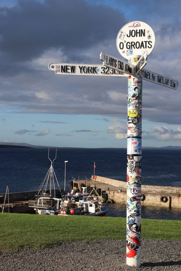
Duncansby Head: A Wild and Spectacular Coastal Landmark (Optional but Highly Recommended)
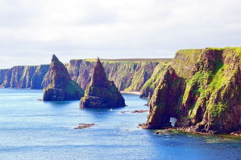
Just beyond John O’Groats, Duncansby Head is where the landscape becomes truly dramatic. High cliffs, huge sea stacks, and thriving seabird colonies make this one of the most spectacular coastal viewpoints in northern Scotland.
The walk out to the cliffs is short and easy, and the views over the Duncansby Stacks and the churning waters below are among the most memorable of the entire journey.
If you visit only one place beyond the signpost, make it this.
Bonus Information for Orkney Islands
The Orkney Islands are not part of the North Coast of Scotland route, but they are a popular extension for travellers who want to explore further north beyond the mainland.
Crossing the Pentland Firth to Orkney feels like stepping into a different country. The islands have their own distinct landscape, history and atmosphere, shaped by sea, stone and an almost unbelievable concentration of prehistoric sites.
How to Think About Orkney in This Journey
Orkney is not a quick add-on. It deserves at least two or three days, and more if you want to explore properly. Orkney is best seen not as a detour, but as an extension into a deeper, older world — a place where the prehistoric story you’ve been glimpsing all the way up the coast reaches its fullest and most extraordinary expression.
Orkney – A World Beyond the Mainland
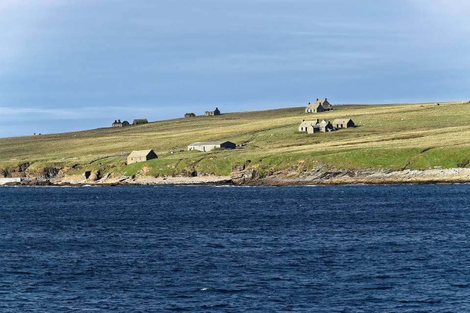
-
Two main ferry operators, NorthLink Ferries and Pentland Ferries, provide year-round services, while a seasonal ferry runs between John O’ Groats and Orkney. NorthLink Ferries also runs ferries to the Shetland Islands. Advance booking is recommended, especially during peak season.
John O’ Groats to Burwick Ferry (Passenger Only)
Operates seasonally (April to late September).
Crossing time: ~40 minutes.
The shortest crossing, ideal for a quick trip to Orkney’s southern islands.
Gills Bay to St. Margaret’s Hope Ferry (Car & Passenger)
Year-round service operated by Pentland Ferries.
Crossing time: ~1 hour.
Arrives in South Ronaldsay, with a road connection to Orkney’s Mainland, including Kirkwall and Skara Brae.
Gills Bay is located 4 miles west of John O’ Groats in Canisbay, Wick (KW1 4YB).
Scrabster to Stromness Ferry (Car & Passenger)
Year-round service operated by NorthLink Ferries.
Crossing time: ~90 minutes.
Arrives in Stromness on Orkney’s Mainland, convenient for exploring sites like Skara Brae, the Ring of Brodgar, and Maeshowe.
This route passes the Old Man of Hoy sea stack, offering a scenic ferry journey.
NorthLink Ferries to Shetland (Via Orkney)
NorthLink also operates longer ferry routes from Aberdeen to Orkney (Kirkwall) and onward to Shetland.
-
For those preferring to fly, Kirkwall Airport (KOI) is Orkney’s main airport, with Loganair operating regular flights from major Scottish cities.
Flights to Kirkwall Airport:
Aberdeen to Orkney (~1 hour)
Edinburgh to Orkney (~1 hour 15 minutes)
Glasgow to Orkney (~1 hour 15 minutes)
Some flights connect via Inverness.
There is also a small airport in Sumburgh, Shetland, for those travelling further north. Once in Orkney, car rentals, buses, and taxis are available for exploring the islands.
-
Renting a car is a convenient way to explore the Orkney Islands, as it provides flexibility and access to remote areas. Car rental companies operate in Kirkwall and Stromness, and booking in advance is advisable, especially during peak tourist season.
Orkney's public bus service, operated by Stagecoach, connects major towns and villages on the islands. Limited bus services operate in more remote areas, so it's essential to check schedules in advance.
Why Go to Orkney? Because this is one of the most important prehistoric landscapes in Europe.
Orkney Highlights
Skara Brae – A 5,000-year-old Neolithic village, preserved in astonishing detail.
Ring of Brodgar & Stones of Stenness – Two of the great ceremonial stone circles of the ancient world.
Maeshowe – A massive chambered cairn aligned with the winter solstice.
Yesnaby Cliffs – Wild Atlantic coast scenery and huge skies.
Kirkwall & St Magnus Cathedral – The cultural and historical heart of the islands.
Together, these sites form the Heart of Neolithic Orkney, a UNESCO World Heritage landscape that rivals anything in Europe.
-
The Orkney Islands are a remote and historically rich archipelago located off the northern coast of Scotland, separated from the mainland by the Pentland Firth. Comprising around 70 islands, of which 20 are inhabited, Orkney is known for its stunning landscapes, prehistoric sites, Norse heritage, and strong maritime traditions. The islands have been home to human settlements for over 5,000 years, with some of the best-preserved Neolithic, Pictish, and Viking remains in Britain. Today, Orkney is a thriving community, blending its ancient history with modern industries such as renewable energy, farming, fishing, and tourism.
Geography and Location
Orkney lies approximately 10 miles (16 km) north of the Scottish mainland, across the Pentland Firth, a stretch of water known for its strong tidal currents and unpredictable seas. The archipelago consists of:
Mainland Orkney – The largest and most populated island, home to Kirkwall (the capital) and Stromness.
Smaller Islands – These include South Ronaldsay, Hoy, Rousay, Westray, Sanday, and North Ronaldsay, each with its own unique landscape and cultural heritage.
The islands are low-lying, with gently rolling farmland, rugged sea cliffs, and expansive beaches. The highest point in Orkney is Ward Hill on Hoy, rising to 479 metres (1,571 ft). The surrounding waters of Scapa Flow, a natural harbour, have played a crucial role in maritime history and naval warfare.
The climate in Orkney is mild yet windy, influenced by the North Atlantic Drift. While temperatures are relatively moderate year-round, strong winds and storms are common, shaping the islands’ treeless landscapes.
History of the Orkney Islands
Prehistoric Orkney: The Neolithic Age (c. 4000–2000 BC)
Orkney’s history stretches back over 5,000 years, with some of the best-preserved Neolithic sites in Europe. The "Heart of Neolithic Orkney", a UNESCO World Heritage Site, includes:
Skara Brae – A remarkably well-preserved Stone Age village, often referred to as Scotland’s Pompeii.
Maeshowe – A chambered tomb aligned with the winter solstice, later carved with Viking runes.
Ring of Brodgar and Standing Stones of Stenness – Massive stone circles that may have served as ritual or ceremonial sites.
These sites suggest that Orkney was a flourishing centre of Neolithic life, with advanced farming communities and elaborate stone structures that predate Stonehenge and the Great Pyramids.
The Picts and Early Scots (c. 2000 BC – AD 800)
Following the Neolithic period, Orkney became home to the Picts, a mysterious Celtic-speaking people who built brochs (stone towers), hill forts, and elaborate carvings. Pictish influence can still be seen in sites such as the Brough of Birsay.
Christianity arrived in Orkney around the 6th or 7th century AD, likely brought by missionary monks from Ireland and Scotland.
The Viking Age (AD 800–1468): Orkney Under Norse Rule
From the 9th century, Orkney was settled by Vikings from Norway, who established Norse earldoms and made the islands an important maritime power in the North Atlantic. The Orkneyinga Saga, a medieval Norse text, details the exploits of the Viking Earls of Orkney, who ruled with strong ties to Norway.
Kirkwall’s St. Magnus Cathedral, built in the 12th century, stands as a lasting reminder of Orkney’s Norse heritage. Even today, many Orcadian place names, dialect words, and cultural traditions reflect their Scandinavian roots.
In 1468, Orkney was ceded to Scotland as part of a dowry payment when King Christian I of Denmark and Norway married his daughter Margaret to James III of Scotland. Despite this transfer, Orkney retained a strong Norse identity.
Early Modern and Industrial Orkney (16th–19th Century)
During the 16th to 19th centuries, Orkney remained a rural farming and fishing community, with trade links to northern Europe and the Scottish mainland. Stromness developed into a major port, supplying whaling and Hudson’s Bay Company ships heading for the Arctic.
Orkney in the World Wars (20th Century)
Orkney played a pivotal role in both World Wars, particularly in Scapa Flow, one of Britain’s most important naval bases. Key events include:
The scuttling of the German fleet in Scapa Flow in 1919, one of the largest acts of naval destruction in history.
The sinking of HMS Royal Oak by a German U-boat in 1939, leading to the construction of the Churchill Barriers to prevent further attacks.
The construction of the Italian Chapel, built by Italian prisoners of war during WWII, which remains a poignant historical site.
Orkney Today: A Thriving Island Community
Today, Orkney is a thriving and modern island community, known for its sustainable energy production, strong agricultural industry, and rich tourism sector. Many Orcadians work in farming, fishing, renewable energy, and creative industries. The islands are particularly famous for:
Orkney Whisky (Highland Park & Scapa distilleries)
Traditional crafts (wool products, jewellery, and pottery)
Orkney cheese and seafood
Tourism continues to grow, with visitors drawn to the islands’ archaeological wonders, Viking history, coastal beauty, and abundant wildlife.
Final Thoughts on Orkney
With a history stretching back over 5,000 years, Orkney is a land where Neolithic stone circles, Viking settlements, and wartime relics sit alongside thriving modern communities. The islands offer stunning landscapes, a rich cultural heritage, and an adventurous spirit, making them one of the most fascinating destinations in Scotland. Whether visiting for a day trip or an extended stay, Orkney provides an unforgettable journey through Scotland’s ancient and maritime past.
-
Explore Orkney's ancient history by visiting UNESCO World Heritage Sites such as Skara Brae, Maeshowe, Standing Stones of Stenness and the Ring of Brodgar. Don't miss St. Magnus Cathedral in Kirkwall and the Italian Chapel on Lamb Holm.
Skara Brae - Skara Brae is a Neolithic village located on the west coast of Mainland, the largest island in the Orkney archipelago. It is one of the most well-preserved Neolithic settlements in Europe and is designated as a UNESCO World Heritage Site. Skara Brae dates back to around 3200 BCE, making it older than Stonehenge and the Great Pyramids of Egypt. It was inhabited for several centuries during the Neolithic period. The village was buried under sand dunes for thousands of years until it was uncovered by a severe storm in 1850. Excavations conducted in the 20th century revealed the remarkably well-preserved remains of the village. Skara Brae consists of several stone-built houses connected by passageways, forming a clustered village. The houses are constructed from flat stone slabs and divided into separate rooms for living, sleeping, and storage.
Maeshowe - Maeshowe is located on the mainland of Orkney, near the village of Stenness. It is part of the Heart of Neolithic Orkney UNESCO World Heritage Site, which also includes nearby sites such as Skara Brae, the Ring of Brodgar, and the Standing Stones of Stenness. Maeshowe is a Neolithic chambered cairn dating back over 5,000 years, making it one of the finest examples of Neolithic architecture in Scotland. It was built around 2800 BCE and served as a burial tomb for ancient inhabitants of Orkney. Maeshowe is renowned for its well-preserved interior, which contains Viking graffiti carved into the walls. These carvings, dating back to the 12th century, provide valuable insights into Viking culture and history.
Ring of Brodgar - The Ring of Brodgar is located on the mainland of Orkney, near the village of Stenness. It is part of the Heart of Neolithic Orkney UNESCO World Heritage Site, which also includes nearby sites such as Skara Brae, Maeshowe, and the Standing Stones of Stenness. The Ring of Brodgar is a Neolithic stone circle dating back over 4,500 years, making it one of the largest and most impressive stone circles in the British Isles. It consists of 27 standing stones arranged in a circular formation, with a diameter of approximately 104 metres. The Ring of Brodgar is surrounded by a circular ditch and bank, which may have had symbolic or practical significance for its builders.
Standing Stones of Stenness - The Standing Stones of Stenness are located on the mainland of Orkney, near the village of Stenness. They are part of the Heart of Neolithic Orkney UNESCO World Heritage Site, which also includes nearby sites such as the Ring of Brodgar, Skara Brae, and Maeshowe. The Standing Stones of Stenness are a Neolithic stone circle dating back over 5,000 years, making them one of the oldest stone circles in Scotland. The site originally consisted of 12 standing stones arranged in an elliptical formation, with some stones reaching over 5 meters in height. Today, only four of the original standing stones remain standing, along with a large stone known as the "Watch Stone" located nearby. The other stones are believed to have been removed or destroyed over the centuries. The site is surrounded by a circular ditch and bank, which may have had symbolic or practical significance for its builders.
-
The Orkney Islands in Scotland are home to several museums that showcase the rich history, culture, and heritage of the archipelago. Here are some notable museums in Orkney:
Orkney Museum: Located in Kirkwall, the Orkney Museum offers insights into the history and archaeology of Orkney. The museum's exhibits cover a wide range of topics, including prehistory, Norse heritage, maritime history, and the islands' natural environment.
St. Magnus Cathedral: Although primarily a place of worship, St. Magnus Cathedral in Kirkwall also houses a museum with displays on the cathedral's history, architecture, and religious significance. Visitors can explore the cathedral's interior and learn about its medieval origins.
Scapa Flow Visitor Centre and Museum: Located in Lyness on the island of Hoy, this museum focuses on the naval history of Scapa Flow during both World Wars. Exhibits cover topics such as naval warfare, shipwrecks, and the lives of servicemen stationed in Orkney.
Italian Chapel: Situated on the island of Lamb Holm, the Italian Chapel is a unique museum housed within a chapel built by Italian prisoners of war during World War II. The museum showcases the chapel's history and features exhibits on its construction and decoration.
Orkney Wireless Museum: Located in Kirkwall, this museum celebrates the history of wireless communication in Orkney. Exhibits include vintage radio equipment, telecommunication devices, and displays on the role of wireless communication during wartime.
Kirbuster Farm Museum: Situated on the island of Orkney Mainland, Kirbuster Museum offers a glimpse into traditional Orkney farm life. Visitors can explore a preserved farmhouse and learn about traditional farming practices, domestic life, and crafts.
-
Other archaeological sites:
Ness of Brodgar: The Ness of Brodgar is an ongoing archaeological excavation located between the Ring of Brodgar and the Standing Stones of Stenness. It is one of the largest and most significant Neolithic excavations in Northern Europe, revealing a complex settlement dating back over 5,000 years.
Cuween Hill Chambered Cairn: Cuween Hill Chambered Cairn is a Neolithic burial chamber located near Finstown on Mainland Orkney. Dating back over 5,000 years, the chambered cairn is notable for its well-preserved interior and archaeological finds, including human and animal remains.
Tomb of the Eagles: The Tomb of the Eagles, also known as Isbister Chambered Cairn, is a Neolithic chambered tomb located on South Ronaldsay. Discovered in the 1950s, the tomb contained a large collection of human bones and eagle talons, providing valuable insights into Neolithic burial practices and symbolism. This attraction was closed at the time of writing. Please check directly before travelling.
Outdoor Activities: Enjoy outdoor pursuits such as hiking, cycling, birdwatching, and wildlife spotting. Orkney's rugged coastline, sandy beaches, and dramatic cliffs provide opportunities for exploration and photography.
Whisky Tasting: Visit local distilleries such as Highland Park Distillery and Scapa Distillery to sample Orkney's distinctive single malt whiskies and learn about the whisky-making process. (It’s not just whisky, Orkney Wine Company provides handcrafted, Sulphur-free, vegan-friendly, fruit wine and liqueur. Made in Orkney using 100% natural ingredients.)
Guided Tours: Join guided Archaeological Tours led by knowledgeable local guides to explore Orkney's ancient sites and learn about its fascinating history. Take a Wildlife Tour boat trip to spot seals, seabirds, and marine wildlife around Orkney's coastline. Puffin-watching trips are popular during the summer months. Take a tour with an STGA Green Badge holder guide to learn more with a tour from Orkney Heritage Tours.
-
The Orkney Islands are rich in World War II history, with numerous points of interest that showcase the islands' strategic significance during the conflict. Here are some key World War II points of interest on the Orkney Islands:
Scapa Flow: Scapa Flow is a natural harbour in Orkney that served as a major naval base for the British Royal Navy during both World Wars. It was the main anchorage for the British fleet in the North Sea and played a crucial role in protecting Allied shipping routes.
Visit the Scapa Flow Museum, located in Lyness on the island of Hoy, the Scapa Flow Visitor Centre and Museum provides insights into the naval history of Scapa Flow during World War I and World War II. The museum features exhibits on naval warfare, shipwrecks, and the lives of servicemen stationed in Orkney.
Several blockships were scuttled in Scapa Flow during both World Wars to block navigational channels and prevent enemy ships from entering the anchorage. Some of these blockship wrecks are still visible in the waters of Scapa Flow and are popular dive sites for wreck diving enthusiasts.
Churchill Barriers: The Churchill Barriers are a series of causeways constructed during World War II to block the eastern approaches to Scapa Flow and improve its defenses against enemy submarines. Today, the barriers serve as roadways connecting the Orkney mainland with several islands. Following the sinking of the British battleship HMS Royal Oak by a German U-boat in 1939, it became evident that the existing defenses of Scapa Flow were inadequate. To enhance the protection of Scapa Flow, the British government initiated the construction of barriers to block the eastern approaches to the anchorage. Construction of the barriers began in May 1940 and was completed in 1944. The project involved the labour of thousands of military personnel and civilian workers, including Italian prisoners of war.
The barriers consist of four causeways: Barrier No. 1 (Churchill Barrier), Barrier No. 2 (Churchill Barrier), Barrier No. 3 (Glimps Holm), and Barrier No. 4 (Burray). The primary purpose of the Churchill Barriers was to restrict access to Scapa Flow and prevent enemy submarines from entering the anchorage.
Italian Chapel: The Italian Chapel is a remarkable chapel located on the island of Lamb Holm, constructed by Italian prisoners of war during World War II. Using salvaged materials, the prisoners transformed two Nissen huts into a beautiful chapel adorned with intricate artwork and decorations.
Orkney is home to numerous war memorials commemorating the servicemen and women who served and lost their lives during World War II. These memorials can be found in towns and villages across the islands, serving as poignant reminders of the sacrifices made during the conflict.
Visiting these World War II points of interest on the Orkney Islands provides a deeper understanding of the islands' wartime history and the role they played in the defense of the United Kingdom during World War II.
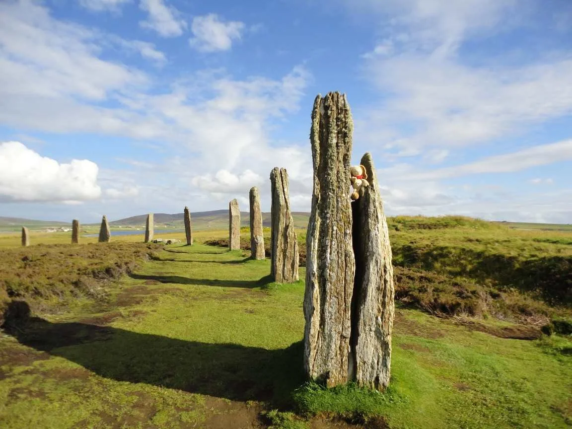
-
It is possible to visit Orkney as a day trip, particularly from John O’ Groats, where the John O’ Groats Ferry offers a short crossing (about 40 minutes) to Burwick on South Ronaldsay. From there, visitors can explore Orkney’s highlights on an organised day tour or with a self-guided itinerary. However, to fully experience Orkney’s rich history, stunning landscapes, and vibrant local culture, a 2- or 3-day visit is ideal.
What Can You See in One Day on Orkney?
A one-day trip is best suited for those wanting to experience Orkney’s most famous historical and archaeological sites, as well as some of its beautiful coastal landscapes. Many visitors opt for a guided tour, which allows for efficient travel between attractions.
Is a Day Trip Worth It?
A one-day visit allows you to see Orkney’s most famous sites, particularly the Neolithic Heart of Orkney (a UNESCO World Heritage Site). However, it is a fast-paced itinerary, and you won’t have time to explore Orkney’s islands, nature, or more remote sites. If you have the flexibility, a longer stay is highly recommended.
-
Morning: Arrival and Neolithic Orkney
Take the early ferry from John O’ Groats to Burwick (about 40 minutes).
Drive or take a tour bus across Orkney’s dramatic landscapes, crossing the famous Churchill Barriers, built during WWII.
Visit Skara Brae, a 5,000-year-old Neolithic village that is one of Europe’s best-preserved prehistoric settlements. Walk through the stone-built houses, marvel at the original furniture, and learn about its history at the visitor centre.
Midday: Orkney’s Ancient Wonders
Stop at the Ring of Brodgar, a massive Neolithic stone circle, older than Stonehenge.
Visit the Standing Stones of Stenness, another prehistoric monument with an atmospheric setting.
Explore the Maeshowe Chambered Cairn, an ancient burial tomb famous for its Viking-era runic inscriptions.
Afternoon: Kirkwall and Return Ferry
Spend time in Kirkwall, the capital of Orkney, visiting the St. Magnus Cathedral, the impressive Earl’s Palace, and the Orkney Museum.
Browse local shops and craft stores, picking up Orkney cheese, whisky, or handmade crafts.
Return to Burwick for the afternoon ferry back to John O’ Groats.
-
Day 1: Neolithic Orkney and Kirkwall
Skara Brae, Ring of Brodgar, Standing Stones of Stenness, and Maeshowe (as in the one-day itinerary).
Explore Kirkwall more thoroughly—visit its shops, cafés, and historic sites at a relaxed pace.
Take a whisky tour at Highland Park or Scapa Distillery.
Stay overnight in Kirkwall or Stromness.
Day 2: The Orkney Coast and Scapa Flow
Visit Brough of Birsay, a tidal island with Viking and Pictish ruins, accessible at low tide.
Explore Yesnaby Cliffs, known for their dramatic sea stacks and rugged coastal scenery.
Discover Scapa Flow, a historic naval site from both World Wars, with wartime relics and fascinating stories.
Stop at Italian Chapel, a beautifully decorated church built by Italian POWs during WWII.
Return to Kirkwall or Stromness for the ferry back to mainland Scotland.
-
With three days, you can explore one of Orkney’s outer islands, which offer a completely different experience from the main island.
Day 3: Visit an Outer Island
Rousay: Known as the "Egypt of the North" due to its huge number of prehistoric sites, including Midhowe Broch and Cairn.
Hoy: Home to the Old Man of Hoy, a dramatic sea stack, and Scapa Flow’s war history sites.
Westray or Papa Westray: Great for birdwatching, with spectacular clifftop scenery and rare seabird species.
-
Where to Stay on Orkney
For those staying overnight, the best places to base yourself are:
Kirkwall – The capital, with hotels, guesthouses, restaurants, and easy access to mainland attractions.
Stromness – A charming coastal town with historic streets and ferry connections.
Rural Retreats – Options in South Ronaldsay, Birsay, or along the coast for a quieter experience.
In one day, you can experience Orkney’s most famous historic landmarks, including the Neolithic village of Skara Brae, the Ring of Brodgar stone circle, and St. Magnus Cathedral in Kirkwall. A day trip is ideal for those looking to see key archaeological sites and get a taste of Orkney’s heritage.
With two days, you can explore more of Orkney’s coast and wartime history, including the Italian Chapel, Scapa Flow naval sites, and the dramatic sea cliffs of Yesnaby or Brough of Birsay. This allows for a more relaxed pace, with time to visit local distilleries, craft shops, and scenic coastal walks.
A three-day visit lets you venture beyond Orkney’s Mainland to discover its smaller islands, such as Hoy, Rousay, or Westray, each offering remote landscapes, birdwatching, and Viking or Pictish sites. You’ll also have time to explore Stromness, Orkney’s second-largest town, with its charming narrow streets and maritime history.
Where Next?
Reaching John O’Groats feels like an ending, but it is really a decision point in the journey.
From here, you have three very different and equally valid options, depending on your time, energy and priorities.
Option 1: Cross to Orkney
If you have the time, crossing the Pentland Firth to Orkney is one of the most rewarding extensions you can add to this journey. The islands are home to some of the most important prehistoric sites in Europe, dramatic coastal scenery, and a culture with a strong identity of its own. Orkney deserves at least two or three days, and more if you want to explore it properly.
Option 2: Turn South Along the East Coast
If your time has come to an end, this is the natural place to begin the journey back south. You can return down the east coast, either retracing part of your route or taking a faster, more direct line south through Caithness, Sutherland and Easter Ross towards Inverness and beyond.
Option 3: Continue the Journey West
If you are following the full northern route, the adventure is far from over. From John O’Groats, the road now turns west and begins one of the most dramatic stretches of the entire journey: the north coast.
The next chapter takes you from John O’Groats to Durness, through some of the wildest and most open landscapes in mainland Britain.
Next Chapter: The North Coast
John O’Groats to Durness
Route: The North - John O’Groats to Durness Includes: Mey > Dunnet > Thurso > Scrabster > Bettyhill > Tongue > Durness
Drivetime: 3 hours 40 mins to 4 hours 10 mins. Approx length: 101 miles (163km).
This section trades the North Sea for the Atlantic, and the feeling of reaching the edge for the feeling of crossing into something even bigger and wilder.
Uncover More Map
The Uncover More map highlights key points of interest, scenic viewpoints, hidden gems, and much more along the recommended route. To make the most of it, use the map in conjunction with the destination information, and explore additional options in the area you’re visiting to discover even more experiences.
If your iPhone doesn’t load via the Google Map App via the button, check out the Help page for how to update your phone or copy and paste the link into your browser: https://bit.ly/nc500-uncover-more
North Coast 500 (Scotland) Last updated: 28 January 2026
Some links may earn Uncover Britain a small commission at no extra cost to you. This helps support the ongoing creation, review and presentation of our road trip guides.
Route information and listings are provided for general guidance only. Always use your preferred navigation system and check official websites to confirm suitability, opening times and the latest details before travelling.
Our guides are reviewed regularly and supported by a mix of editorial research and digital tools to help keep content clear and up to date. If you spot anything that needs updating, we’re always glad to hear from you.