

19 miles (30 km) with drive time approx. 40 minutes
Customisable and Live Navigation via Google Maps –
click here:
Or use the link to jump to the destinations in the guide below
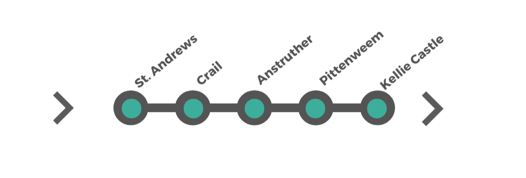
St. Andrews →
Crail →
Anstruther →
Pittenweem →
Kellie Castle
East Neuk of Fife: Fishing Villages, Harbours & a Creative Coast
The East Neuk is one of the most distinctive stretches of coastline in Scotland — a compact corner of Fife where small fishing villages sit close together, each shaped by the sea but quietly different in character. Harbours, shore paths and narrow streets tell a story of work, trade and daily life that has unfolded here for centuries.
This section follows the coast east from St Andrews through Crail, Anstruther and Pittenweem before turning inland to Kellie Castle. It’s a journey that moves gently between land and sea: from open beaches and working harbours to quieter lanes, gardens and woodland beyond the shoreline.
What makes the East Neuk special is its scale. Distances are short, the pace is unhurried, and the reward comes from slowing down rather than covering ground. You can linger on harbour walls, follow short coastal paths, browse small galleries or simply watch the rhythm of the tide and boats coming and going.
Ending inland at Kellie Castle adds contrast to the coastal villages, revealing another layer of Fife’s story — one shaped by estates, craftsmanship and creative life away from the water. Together, these places form a natural opening chapter to the wider Fife journey: intimate, characterful and rooted in everyday history rather than grand spectacle.
How to Spend Your Time in East Neuk
East Neuk of Fife is a coastal gem brimming with historic charm, breathtaking sea views, and quaint fishing villages. Whether you have just a single day, a leisurely weekend, or an extended stay, this pocket of Scotland promises a captivating blend of heritage and natural beauty. St Andrews is enchanted with its centuries-old university, iconic golf courses, and medieval ruins, while Crail, Anstruther, and Pittenweem offer picturesque harbours and mouthwatering seafood. The grandeur of Kellie Castle adds a dash of medieval intrigue to the region’s scenic allure. Explore one of our tailored itineraries to experience the best of the East Neuk—at your own pace.
-
Morning: St Andrews
St Andrews Castle & Cathedral
Arrive early to beat the crowds and explore the iconic ruins, learning about St Andrews’ medieval past.
Stroll the Town & University Area
Wander through the historic streets and the University of St Andrews campus. Grab a quick coffee or pastry from a local café.
Midday: Anstruther
Drive or Bus to Anstruther (approx. 15–20 minutes from St Andrews)
Harbour Walk & Scottish Fisheries Museum (optional)
If time allows, pop into the museum to discover the region’s maritime heritage.
Lunch at the Harbour
Sample the famous fish and chips from a local chippy—often cited among the best in Scotland.
Early Afternoon: Pittenweem
Short Hop to Pittenweem (approx. 5 minutes by car from Anstruther)
Art Galleries & Harbour
Explore the narrow lanes dotted with local galleries and studios, then take a leisurely stroll along the charming harbour.
Late Afternoon: Kellie Castle
Drive to Kellie Castle (approx. 10 minutes from Pittenweem)
Historic House & Gardens
Tour the 14th-century tower house, admire the period interiors, and enjoy a quick walk through the walled garden (check seasonal opening times).
Evening: Crail or Return to St Andrews
Option A: Finish in Crail
Head to Crail (approx. 10 minutes from Kellie Castle) for a tranquil harbour walk and sunset views. If you’re staying overnight, enjoy a relaxed evening meal at a local pub or café.
Option B: Return to St Andrews
Drive back to St Andrews (approx. 20–25 minutes) for dinner. Stroll along West Sands or explore more of the town’s night-time atmosphere before departing.
-
Day 1: St Andrews Highlights
Morning: Stroll through the historic town center. Visit St Andrews Cathedral ruins and St Andrews Castle perched on the cliffs.
Afternoon: Explore the Old Course—the Home of Golf—and the British Golf Museum to learn about the game’s storied past. Walk along West Sands for sea views.
Evening: Enjoy dinner in one of the many restaurants or pubs. Taste local seafood or traditional Scottish fare.
Day 2: Crail & Anstruther
Morning: Drive or take a bus to Crail, a quaint fishing village with a picturesque harbour. Wander the narrow streets and pop into local craft shops.
Afternoon: Head to Anstruther. Savour award-winning fish and chips at the harbour, then visit the Scottish Fisheries Museum to learn about the region’s maritime heritage.
Evening: Enjoy a seaside stroll or relax in a cosy pub along the waterfront in Anstruther.
Day 3: Pittenweem & Kellie Castle
Morning: Short drive to Pittenweem. Explore local art galleries and the charming harbour area. If time allows, take a leisurely coastal walk between villages on the Fife Coastal Path.
Afternoon: Venture to Kellie Castle, a beautifully preserved 14th-century tower house with stunning walled gardens. Delve into its history and admire the period interiors.
Evening: Return to St Andrews or stay in one of the East Neuk villages for a final night of relaxed dining and coastal views.
-
Day 1: St Andrews Old Town
Dive deeper into St Andrews:
Morning: Tour the University of St Andrews campus, one of the oldest in the English-speaking world.
Afternoon: Explore the shops and cafés around South Street and Market Street.
Evening: Enjoy local nightlife or a sunset walk on East Sands.
Day 2: Golf & Museums
Morning: Tee off at one of the other St Andrews Links courses (if you’re a golfer), or take a guided walking tour about the town’s history.
Afternoon: Visit the St Andrews Botanic Garden or spend extra time at the British Golf Museum and Wardlaw Museum (University-run, focusing on local history and art).
Evening: Sample fresh seafood at a local restaurant, or experience a whisky tasting.
Day 3: Crail & Anstruther
Morning: Travel to Crail. Enjoy a leisurely brunch overlooking the harbour.
Afternoon: Head to Anstruther for the Scottish Fisheries Museum and a classic harbour walk. Indulge in fish and chips or explore local cafés.
Evening: Stay overnight in Anstruther or return to St Andrews.
Day 4: Pittenweem & Kellie Castle
Morning: Explore Pittenweem, known for its thriving arts scene. Visit independent galleries and studios.
Afternoon: Tour Kellie Castle. Wander through its walled garden and discover its medieval architecture.
Evening: Relax in a traditional pub, reflecting on the day’s heritage discoveries.
Day 5: Coastal Path & Relaxation
Morning: Walk a section of the Fife Coastal Path between Anstruther and Pittenweem or Crail. Enjoy panoramic sea views and look out for wildlife.
Afternoon: Return to St Andrews or pick another East Neuk village to unwind. Browse local shops for souvenirs, or sit by the harbour soaking up the coastal ambience.
Evening: End your trip with a memorable meal in St Andrews or your chosen village.
-
Day 1: St Andrews – History & Architecture
Morning: Begin at St Andrews Cathedral and Castle for an in-depth historical tour.
Afternoon: Walk the University of St Andrews quad areas and explore local museums like the Wardlaw Museum.
Evening: Stroll along West Sands and dine with a view of the sea.
Day 2: Golf & Leisure in St Andrews
Morning: If golf is your passion, book a round at a local course. Otherwise, continue exploring the town’s unique shops.
Afternoon: Visit the St Andrews Botanic Garden or relax at a café.
Evening: Enjoy a pub crawl or whisky tasting, discovering traditional Scottish hospitality.
Day 3: Crail
Morning: Head to Crail, exploring the harbour and stepping into Crail Pottery for local crafts.
Afternoon: Lunch at a harbour café, then meander through the village streets. You might also enjoy a scenic walk to nearby beaches.
Evening: Stay overnight in Crail, enjoying its peaceful atmosphere once day-trippers depart.
Day 4: Anstruther
Morning: Take a short drive or bus to Anstruther. Explore the Scottish Fisheries Museum in depth.
Afternoon: Indulge in the renowned fish and chips, then walk along the pier. If you’re visiting in season, check out boat tours or special events along the harbour.
Evening: Relax at a local pub or catch a beautiful East Neuk sunset.
Day 5: Pittenweem & Kellie Castle
Morning: Stroll around Pittenweem, meeting local artists and visiting galleries.
Afternoon: Drive to Kellie Castle to admire its medieval tower house architecture and lush gardens.
Evening: Return to St Andrews or stay locally; enjoy dinner at a nearby inn or restaurant.
Day 6: Coastal Path Exploration
Morning: Hike the Fife Coastal Path between any two East Neuk villages (e.g., Crail to Anstruther or Anstruther to Pittenweem).
Afternoon: Break for a seafood lunch and continue the walk at a leisurely pace, taking photographs of the dramatic coastline.
Evening: Unwind in a cosy B&B or guesthouse, savoring a quiet night in the East Neuk.
Day 7: Final Day in St Andrews
Morning: Wrap up any missed attractions—perhaps a guided tour of the Old Course or a visit to the British Golf Museum if you haven’t gone yet.
Afternoon: Enjoy shopping in the town’s independent boutiques for Scottish gifts and souvenirs.
Evening: Depart Fife or extend your stay if you’ve fallen in love with this coastal haven.
The Fife Coastal Path along the East Neuk
Running for 116 miles around the Fife coastline, the Fife Coastal Path is the quiet thread that links St Andrews, Crail, Anstruther and Pittenweem together. You don’t need to “walk the path” in any formal sense to benefit from it. In this part of Fife, it simply provides a series of short, easy, memorable stretches that help you understand how the coastline and villages connect.
Throughout this section of the guide, you’ll see suggestions for dipping into the path for 20–60 minutes at a time. These aren’t hikes — they’re short coastal wanderings that add atmosphere, views and breathing space between harbour stops, cafés and historic sights.
Below is where the path is most rewarding to use as you travel this route.
St Andrews — Cliffs, dunes and big sea views
Best stretch: East Sands heading south along the cliffs
Character: Open views, dramatic coastline, dunes and skyline views back to town
Ideal for: A 30–45 minute out-and-back before leaving St Andrews
This is where the coastline first feels expansive and sets the tone for what follows.
Crail — Harbour to Roome Bay
Best stretch: Crail Harbour to Roome Bay
Character: Clifftops, wildflowers, seabirds and views back to the village
Ideal for: A gentle pre- or post-coffee harbour walk
This is one of the prettiest, most photogenic short sections of the whole route.
Anstruther → Pittenweem — Working shoreline
Best stretch: Anstruther → Cellardyke → Pittenweem
Character: Fishing cottages, boats, nets, real harbour life
Ideal for: A one-way shoreline walk between villages
This is where you understand the East Neuk as a connected coastal community rather than separate stops.
Pittenweem — Shoreline, rocks and harbour edges
Best stretch: Either direction from the harbour along the rocks
Character: Rocky shoreline, small caves, sea textures
Ideal for: A short exploratory wander rather than a set walk
This section feels rugged and close to the water.
Kellie Castle — Woodland contrast
Estate paths and woodland walks rather than coastal scenery
A deliberate shift in landscape after the shoreline villages
This change of setting rounds off the day and shows a different side of Fife.
How to use this
You might not want to walk the full path, but this guide gives you options. You’re being shown where to step onto it briefly to add views, air and atmosphere to the journey between villages.
St Andrews — Ruins, Learning & the Edge of the Sea
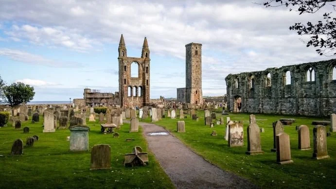
St. Andrews is where Fife’s story feels most concentrated. Cathedral ruins sit above the shoreline, university streets run down towards the sea, and the famous links stretch out beside a vast beach. Nowhere else in Scotland combines medieval religion, intellectual life and sporting heritage in such a small, walkable space.
This is not just a historic town to “see”. It’s a place to wander slowly, where views open up between buildings, the sea is never far away, and the past feels layered rather than preserved.
One of Scotland’s most important medieval religious centres
Home to Scotland’s oldest university (founded 1413)
The spiritual home of golf beside a vast sandy beach
Cathedral, castle and coastline within easy walking distance
A town that rewards slow wandering rather than rushing
A natural starting point for exploring the East Neuk coast
What to See & Do
British Golf Museum & St Rule's Tower — The cathedral ruins show the scale of what was once the largest church in Scotland. Climb St Rule’s Tower for wide views over the town, harbour and coastline.
St Andrews Castle — Perched on the cliffs, this is one of the most atmospheric sites in town, with siege tunnels, underground passages and views out across the North Sea.
West Sands Beach — A vast, open stretch of sand backed by the Old Course. Ideal for a long walk, especially in the evening light.
University of St. Andrews streets & quads — The historic buildings of the university are woven through the town. Wandering here is part of the experience rather than a checklist.
St. Andrews Botanic Garden — A calm, green break from the stone and sea.
St. Andrews Aquarium & East Sands Leisure Centre — Useful options for families or poor weather.
Golf in St Andrews
St Andrews is inseparable from golf, but you don’t need to play to appreciate it.
Walk beside the Old Course and St. Andrews Links and watch play unfold against the beach backdrop
Visit the British Golf Museum to understand why this place matters globally and learn more about the St. Andrews Links
If you do play, book well in advance — this shapes your day here
-
St Andrews began as an early religious settlement linked to the cult of Saint Andrew, Scotland’s patron saint. By the 12th century it had become the centre of the medieval church in Scotland, drawing pilgrims from across Europe to its cathedral.
The town later became home to the University of St Andrews in 1413, shaping Scotland’s intellectual life for centuries. During the Reformation, figures such as John Knox preached here, marking the town as a focal point of religious change.
Alongside this religious and academic history, golf developed on the links beside the town from the 1400s, eventually making St Andrews the recognised home of the sport.
-
Parking
Peterson Street Car Park — central, good for cathedral/castle/university exploring
Argyle Street Car Park — convenient for town centre wandering
West Sands Car Park — best if you want beach and golf views first
East Sands Car Park — useful for families and quieter access to the shore
Getting around
Best explored on foot once parked — everything is close together
Arrive earlier in peak season; the town is compact and fills quickly
Tip for your day
Park once, explore the cathedral and castle area on foot, wander through town, then finish with a long walk on West Sands before leaving. -
This is a simple loop that lets you understand St Andrews without needing a map or rushing between sights. Park once, then follow this on foot.
Start: Cathedral & Harbour
Begin at St Andrews Cathedral. Walk through the ruins and, if open, climb St Rule’s Tower for the view. From here, follow the path down towards the small harbour and look back at the cathedral from sea level — one of the best perspectives in town.
Clifftop to the Castle
Follow the coastal path north for a few minutes to St Andrews Castle. Even without going inside, the clifftop position and sea views are worth the stop.
Into the University Streets
Head inland along North Street and South Street, passing university buildings, stone lanes and small courtyards. This is where the town’s academic character really shows.
Finish: The Links & West Sands
Continue west until the streets open onto the famous links beside the Old Course. Cross towards West Sands Beach and take a short walk along the sand with the course behind you.
You’ll have seen cathedral, castle, university, golf and coastline in one gentle loop — which is exactly how St Andrews is best experienced.
-
No place in the world is more closely associated with golf than St Andrews Links.
Golf has been played here since at least the early 1400s, when townspeople used the rough coastal ground known as the Links for informal games. The land was common ground — shared for grazing, walking and recreation — which is why the course still feels open and woven into the town rather than enclosed.
By the 1500s, the layout that would become the Old Course had begun to take shape. Its double greens, shared fairways and natural hazards were not designed but evolved over time, shaped by wind, sand, rabbits and repeated play. This is why the course feels organic rather than engineered.
In 1754, the Royal and Ancient Golf Club of St Andrews was formed here. The R&A went on to codify the rules of golf that are still followed across most of the world today, cementing St Andrews’ role not just as a place to play golf, but as the place that defined how the game is played.
The Old Course at St Andrews is widely regarded as the oldest golf course in the world and remains a working public course. Locals walk dogs across it on Sundays. Visitors cross its fairways to reach the beach. It is both sacred sporting ground and everyday landscape.
The famous Swilcan Bridge, Hell Bunker and the long final approach to the 18th green beside the town are among the most recognisable scenes in global sport.
Even if you never pick up a club, walking beside the Links or visiting the British Golf Museum makes it clear why St Andrews is known, without exaggeration, as the Home of Golf.
Around St Andrews, the Fife Coastal Path feels wide, open and expansive. Leaving the town from East Sands, the path follows low cliffs and grassy edges with constant views over the North Sea and back towards the skyline of St Andrews. This stretch is less about harbours and more about space — dunes, sea air and long coastal views that immediately shift you into a slower pace. Even a short 20–30 minute walk here gives a strong sense of how the coastline begins to unfold before you reach the East Neuk villages further south.

From Coast to Cold War — Crossing Fife’s Quiet Interior
Leaving the shoreline behind, the road inland from St Andrews feels unexpectedly rural. Fields roll gently towards low horizons, farm tracks split off into quiet corners, and there is very little to suggest that anything unusual lies ahead. This is part of the surprise. You move through ordinary Fife countryside before arriving at one of the most extraordinary places on the entire route.
Hidden beneath an unremarkable farmhouse near Troywood is a relic of the Cold War that most people drove past for decades without ever realising it was there.
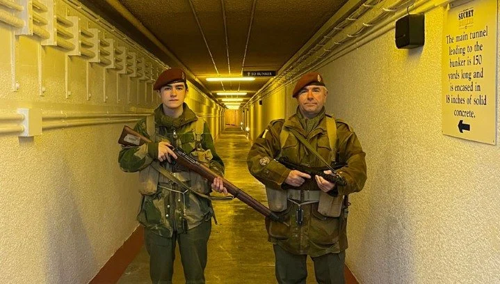
Scotland’s Secret Bunker
An innocent-looking farmhouse conceals the entrance to what was, for over 40 years, Scotland’s hidden command centre in the event of nuclear war.
Scotland’s Secret Bunker (Image copyright Scotland’s Secret Bunker) was built in 1951 and operational until 1993, the bunker sits 100 feet underground, protected by 15 feet of reinforced concrete. This is where senior government officials, military commanders and civil servants would have relocated to run Scotland — and potentially the UK — if the unthinkable had happened.
Inside, the scale is astonishing. Long corridors lead to dormitories, communications rooms, a BBC broadcasting studio, RAF control centre, nuclear operations room, cafeterias and even a small cinema. Maps still line the walls. Equipment remains in place. It feels less like a museum and more like a facility that was simply switched off and left.
It’s one of the most unexpected and memorable stops in Fife, and a striking contrast to the medieval towns and coastal villages you’ll visit next.
Onwards to the East Neuk Coast
From the bunker, the route gently returns you towards the sea. Quiet country roads thread through farmland before the landscape begins to open out again. The air changes. You catch glimpses of the Firth of Forth between hedgerows. The feeling of space returns as you approach the coast.
This is where Fife shifts character once more — from Cold War secrecy and inland stillness to one of Scotland’s most charming and historic fishing villages.
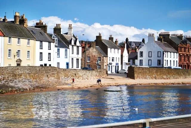
Crail
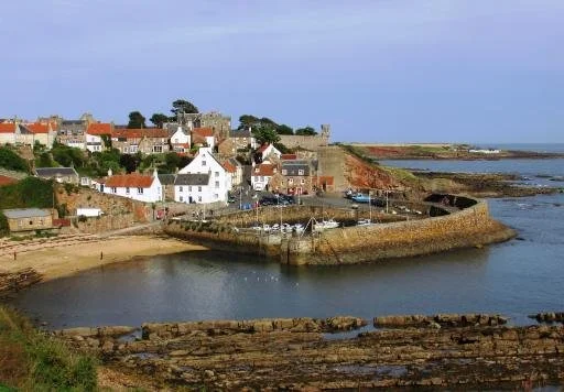
Crail is often the first true East Neuk village visitors encounter, and it sets the tone perfectly.
Pantiled roofs, crow-stepped gables and narrow lanes lead down to a small, perfectly formed harbour where fishing boats still work from the quayside. It’s easy to wander here without a plan — browsing small galleries, independent shops and cafés before drifting back towards the sea.
One of the prettiest and most intact fishing villages in Fife
Compact, walkable and full of character
Strong mix of harbour life, crafts and coastal walking
Easy access to beaches and the Fife Coastal Path
What to See & Do in Crail
Harbour & Shoreline Walks – Wander the historic harbour, watch fishing boats come and go, and follow short stretches of the Fife Coastal Path (see below) for clifftop views and sea air.
Crail Museum and Heritage Centre – Set in a 17th-century tollbooth, this small museum gives excellent context to the village’s maritime history, fishing traditions and everyday life.
Crail Parish Church & Churchyard – A striking medieval kirk with centuries of gravestones and a peaceful setting above the harbour.
Roome Bay – A sandy, sheltered bay just beyond the village, ideal for a short coastal detour, beachcombing or a quiet pause by the water.
Crail Pottery – Working studio and shop producing traditional ceramics; a good place to browse for locally made pieces.
Crail Golfing Society (Balcomie & Craighead Links) – One of the world’s oldest golf clubs, with dramatic true-links courses overlooking the sea, even if you’re just walking past for the views.
-
Crail’s history is deeply tied to fishing, trade and seafaring. The harbour has operated for centuries, and many of the buildings you see today reflect the prosperity brought by maritime trade. Traditional pantiles, crow-stepped gables and narrow wynds give the village a distinctive architectural feel. Over time, artists and craftspeople have been drawn here, adding a creative layer to its working coastal heritage.
-
Harbour car park and on-street parking available
Several cafés, shops and public toilets in the village
Easy walking terrain, mostly level
Beach access at Crail Roome Bay
Good stop for lunch before continuing to Anstruther and Pittenweem
Around Crail, the Fife Coastal Path becomes more intimate and textured. The route threads past the harbour, then quickly leaves the village behind for clifftop paths, rocky inlets and open views across the Firth of Forth. This is where you start to feel how closely the villages sit to the sea. Short sections north or south of Crail reveal quiet coves, seabirds and changing light on the water, making it an ideal place to sample the path without committing to a long walk.
Leaving Crail, the road and the coastal path run almost side by side along the cliffs. The sea stays with you, the views barely change, and within minutes you arrive somewhere that feels noticeably different. Where Crail is quiet and compact, Anstruther, just a few miles away — feels busier and more purposeful — a harbour still working, boats moving, and a waterfront with more energy. The coastline hasn’t changed, but the rhythm of the villages has.
This is one of the shortest hops on the East Neuk — about 2 miles / 5 minutes — and if you weren’t watching for the village sign, you could almost miss where one ends and the next begins.
The harbour road gently becomes narrower, the buildings closer to the sea, and the feel shifts again. Anstruther is open and active; Pittenweem feels tighter, older and more tucked into the shoreline. The Fife Coastal Path links them directly, and walking between the two is one of the nicest short sections anywhere on this coast.
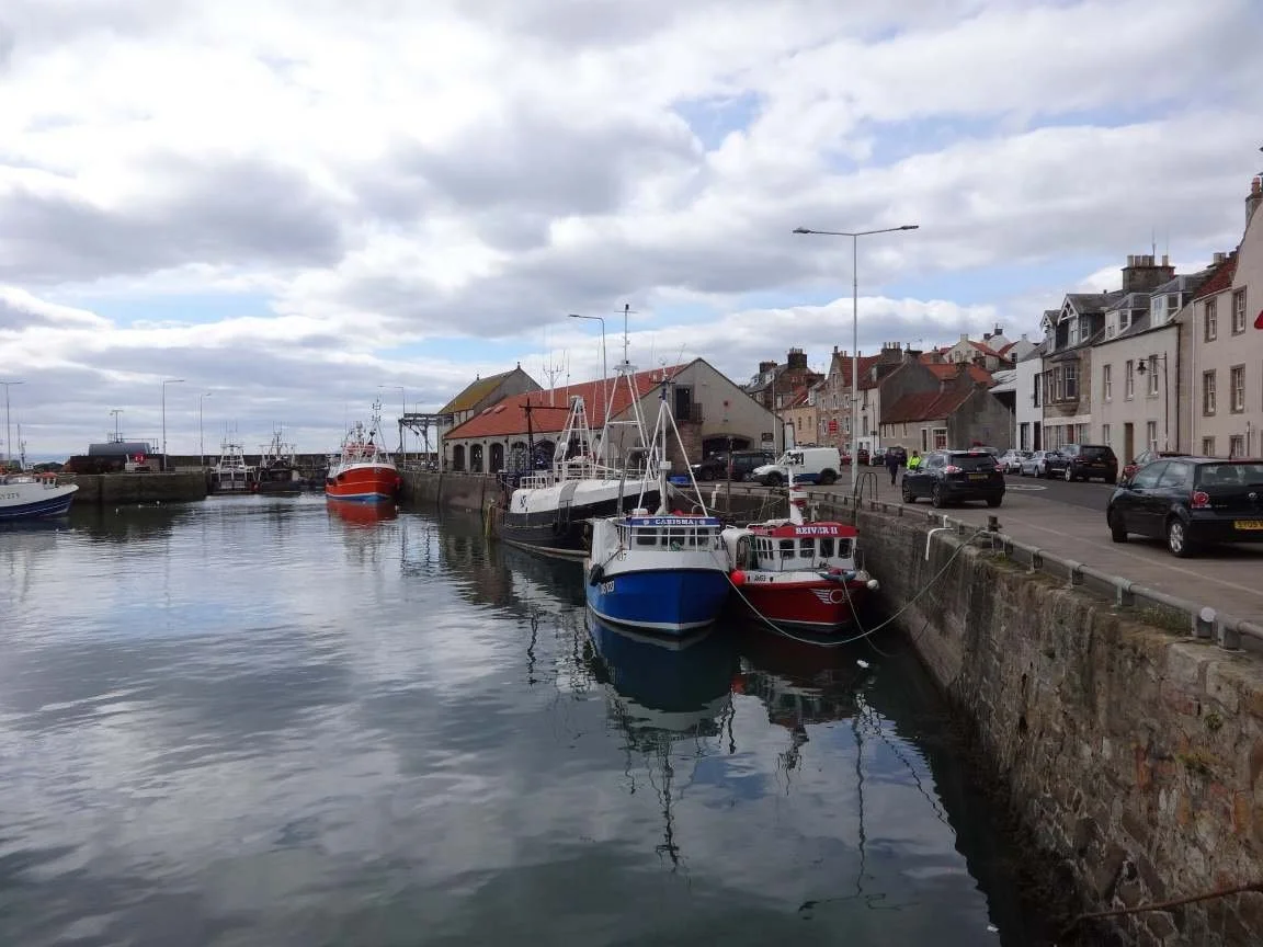
Anstruther — Harbours, Fisheries & Sea Life
Anstruther is one of the liveliest and most characterful stops along the East Neuk. Two small harbours, a strong fishing heritage and a busy waterfront give the town a sense of movement and purpose that contrasts with the quieter villages nearby. It’s a place where you can watch boats, explore maritime history, take to the water, and enjoy some of the best seafood on this stretch of coast.
Active working harbour with constant maritime activity
Excellent insight into Scotland’s fishing heritage
Boat trips to seabird islands and coastal landmarks
Attractive old streets, tolbooths and harbour buildings
Famous fish and chips and good café stops
Easy access to short coastal walks and shoreline views
What to See & Do
Scottish Fisheries Museum — One of the best places in Scotland to understand the history of fishing communities and the boats, tools and lives behind them.
Anstruther Harbour & Billow Ness Beach — Walk the quayside, then cross to this quiet shell beach on the west side of the harbour.
Anstruther Pleasure Cruises — Boat trips out towards the Isle of May and views to the Bass Rock for seabirds, seals and open sea views.
Anstruther Lifeboat Station — Learn about modern sea rescue and the realities of coastal life.
James Street & the Tollbooth — Historic street running along the shore with 16th-century civic buildings.
Cellardyke Harbour — A smaller, quieter harbour just round the corner, still used by local creel boats.
Anstruther Fish Bar,— A well-known stop for freshly landed fish and chips.
Town Trail & Anstruther Golf Club — Self-guided town trail and a compact coastal golf course with wide sea views.
The Fife Coastal Path from Anstruther
Here the Fife Coastal Path feels busy, varied and full of interest. The path threads directly past both harbours before climbing onto open clifftops where the views stretch towards the Isle of May. Walking south towards Pittenweem or north towards Crail quickly leaves the town behind and returns you to quieter shoreline, rocky inlets and seabird cliffs. It’s one of the most rewarding places to sample the path because you move so quickly from harbour life to open coast.
-
Anstruther is a picturesque coastal town in the East Neuk of Fife. The area around Anstruther has been inhabited since ancient times, with evidence of prehistoric settlements and early Celtic communities. Its location on the coast made it ideal for fishing and maritime activities.
Anstruther grew in importance during the medieval period as a fishing village and trading port. It was granted burgh status in the 14th century, allowing it to establish markets and conduct trade with other towns in Scotland and beyond.
By the 16th and 17th centuries, Anstruther had become one of the most prosperous fishing ports in Scotland. Its fleet of fishing boats, known as "drifters," ventured out to the North Sea to catch herring and other fish, contributing to the town's economic success.
Anstruther has a long maritime heritage, with a history of shipbuilding, boat repair, and seafaring. The town's harbour was a bustling hub of activity, with fishermen, sailors, and merchants plying their trade along the coast.
Like many coastal towns in Scotland, Anstruther was affected by wars and conflicts throughout history. During the Anglo-Scottish Wars and the Wars of Scottish Independence, it faced threats from English raids and naval incursions. The town also played a role in the smuggling trade during the 18th century.
In the 19th century, Anstruther continued to thrive as a fishing and trading port. The development of new fishing techniques and technologies, such as steam-powered boats and refrigeration, helped to sustain the local fishing industry.
In the 20th century, Anstruther began to attract tourists drawn to its scenic coastal setting, historic architecture, and maritime charm. The town's picturesque harbour, lined with colourful fishing boats and historic buildings, became a popular destination for visitors exploring the East Neuk of Fife.
Today, Anstruther remains a vibrant community with a strong connection to its maritime heritage.
Pittenweem — Artists’ Harbour & Hidden Corners
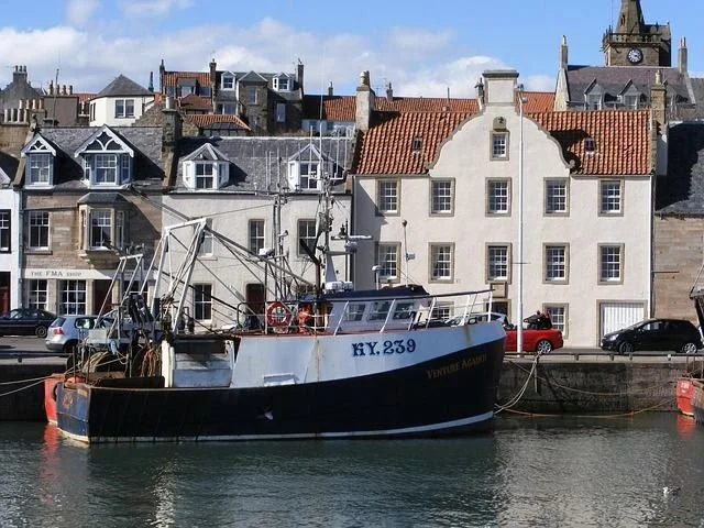
Pittenweem feels like the most intimate of the East Neuk villages. Houses crowd the harbour edge, narrow lanes climb steeply away from the sea, and the whole place has a strong sense of being shaped by fishing and later by artists drawn to its light and atmosphere. It’s a village to explore slowly on foot rather than pass through.
One of the most characterful harbours on the East Neuk
Strong creative and arts community
Compact, atmospheric streets and historic buildings
Excellent access to coastal walking
A sense of everyday life still centred on the sea
What to See & Do
Pittenweem's harbour & Shoreline – Watch boats unloading creels and wander the tight harbour edge.
Pittenweem Priory– Remains of the village’s medieval religious past tucked into the streets.
St. Fillan's Cave – A small, atmospheric cave linked to early Christian pilgrimage, reached via the coastal path.
Galleries & Studios – Numerous small studios and artists’ spaces, especially lively during the August Arts Festival.
Coastal Path Walks (see below) – Excellent clifftop walking in both directions from the village.
Seafood cafés – Ideal stop for a relaxed lunch by the harbour.
Kellie Law– Short inland climb for wide views over the coastline.
The Fife Coastal Path from Pittenweem
From Pittenweem, the Fife Coastal Path feels dramatic and varied. Clifftop sections lead to hidden coves, rocky shelves and long views back towards Anstruther and forward towards St Monans. It’s a particularly rewarding place to walk because the village sits so tightly against the sea — within minutes you feel completely away from roads and settlements, with only the sound of waves and seabirds for company.
Leaving Pittenweem, the road gently pulls away from the sea for the first time since St Andrews. The harbours and cliff paths fall behind and farmland begins to open out ahead. Within ten minutes, you’re in a quieter, greener landscape of hedgerows, fields and estate tracks — a marked contrast to the shoreline villages.
Kellie Castle sits tucked into this countryside, hidden from the coast you’ve just been following, and it feels deliberately removed from the fishing life of the East Neuk. It’s the natural inland full stop to this coastal stretch of the journey.
Kellie Castle — Arts, Craft & Quiet Estate Life
Kellie Castle is a layered mix of medieval tower house and later Arts & Crafts home, rescued from ruin by a family of artists in the late 19th century. Inside, historic rooms sit alongside decorative ceilings, murals and exhibitions that tell the story of creativity as much as defence. Outside, the walled garden and orchard provide a peaceful contrast to the sea you’ve just left behind.
A complete contrast to the coastal villages
Strong Arts & Crafts story alongside medieval fabric
Quiet gardens and estate setting
Compact, unhurried National Trust property
What to See & Do
Explore the tower rooms and historic interiors
See the 16th-century plaster ceiling and Phoebe Anna Traquair mural
Visit exhibitions in the former stables, including work by Hew Lorimer
Wander the Arts & Crafts garden and orchard
Optional Detour: Lower Largo — The Real Robinson Crusoe
A short detour west brings you to Lower Largo, birthplace of Alexander Selkirk, the castaway whose story inspired Robinson Crusoe. It’s a quick, interesting coastal stop if you want one last glimpse of the shore before turning fully towards the Forth.
Transition to the Next Chapter: Towards East Wemyss
From Kellie, the route no longer follows the sea. You begin to cross Fife rather than trace its edge, heading towards the Firth of Forth and a very different story — one of crossings, industry, royal towns and the historic corridor of the south coast.
This is where the East Neuk chapter ends and Historic Fife & the Forth begins.
Uncover More Map
The Uncover More map highlights key points of interest, scenic viewpoints, hidden gems, and much more along the recommended route. To make the most of it, use the map in conjunction with the destination information, and explore additional options in the area you’re visiting to discover even more experiences.
If your iPhone doesn’t load via the Google Map App via the button, check out the Help page for how to update your phone or copy and paste the link into your browser: bit.ly/Fife-Uncover
Kingdom of Fife Last updated: 25 March 2026
Some links may earn Uncover Britain a small commission at no extra cost to you. This helps support the ongoing creation, review and presentation of our road trip guides.
Route information and listings are provided for general guidance only. Always use your preferred navigation system and check official websites to confirm suitability, opening times and the latest details before travelling.
Our guides are reviewed regularly and supported by a mix of editorial research and digital tools to help keep content clear and up to date. If you spot anything that needs updating, we’re always glad to hear from you.