


Customisable and Live Navigation via Google Maps –
click here:
Or use the link to jump to the destinations in the guide below
Peel →
Port Erin →
The Sound →
Port St. Mary →
Castletown →
Port Soderick
The West Coast & Southern Return
From the open landscapes of the north, the route turns south and begins to follow the island’s western coastline, where the character shifts once again. This section brings together some of the Isle of Man’s most distinctive coastal scenery, combining historic towns, harbours and more dramatic stretches of shoreline.
Starting at Peel, with its castle and strong maritime heritage, the journey continues along the west coast before rounding the southern edge of the island. From Port Erin, the route reaches The Sound, where views extend across to the Calf of Man, before continuing through Port St. Mary and the historic capital of Castletown.
The final stretch follows the quieter eastern coastline towards Port Soderick, completing the loop back towards Douglas. It’s a varied and rewarding final section, bringing together many of the island’s defining landscapes and offering a natural, satisfying close to the journey.
31 miles (50km) with drive time approx. 1 hour 20 mins
Connecting from Jurby - total 45 miles (73km) with drive time approx. 1 hour 45 mins
How to Spend Your Time
This section of the Isle of Man is rich in history, coastal beauty, and charming seaside towns, offering a perfect mix of historic landmarks, scenic walks, and breathtaking views. Whether you have one, two, three, or four days, you can explore Peel’s Viking heritage, the sandy shores of Port Erin, the dramatic cliffs at The Sound, and the historic capital of Castletown. From tranquil glens to coastal drives and heritage railways, these itineraries provide a memorable journey through the island’s stunning southwest region.
-
For a short but fulfilling visit, this itinerary covers the top sights in Peel, Castletown, and The Sound.
Peel Castle & Harbour – Start your day at Peel Castle, then take a harbour walk and visit the House of Manannan museum.
Castletown & Castle Rushen – Drive to Castletown, explore Castle Rushen, and walk through the historic town centre.
The Sound & Calf of Man Views – End your day at The Sound, where you can enjoy coastal views, spot wildlife, and visit the Sound Visitor Centre.
-
This itinerary adds Port Erin, Port St. Mary, and more time to explore each location.
Day 1: Peel & Port Erin
Peel Castle & Harbour – Explore Peel Castle, the harbour, and the House of Manannan.
Port Erin Beach & Erin Heritage Trail – Drive south to Port Erin, enjoy a beach walk, and follow the Erin Heritage Trail for a look at the town’s past.
Day 2: The Sound, Port St. Mary & Castletown
The Sound & Calf of Man – Visit The Sound, take in the views of the Calf of Man, and look out for seals and dolphins.
Port St. Mary Breakwater Walk – Explore Port St. Mary’s harbour and breakwater, a great spot for birdwatching and coastal scenery.
Castletown & Castle Rushen – End the day in Castletown, visiting Castle Rushen and the Old Grammar School.
-
This itinerary adds Port Soderick and scenic countryside exploration.
Days 1 & 2: Follow the 2-day itinerary above.
Day 3: Port Soderick & Southern Coastline
Port Soderick Beach & Glen – Start the day with a peaceful walk along Port Soderick Bay, then explore the woodland trails of Port Soderick Glen.
Isle of Man Steam Railway – Board the historic steam train, passing through scenic countryside and charming villages.
Glen Maye & Niarbyl Coastal Walk – Spend the afternoon visiting Glen Maye and Niarbyl, known for dramatic cliffs and sea views.
-
For those wanting extra time to explore at a relaxed pace, this itinerary includes scenic drives and more off-the-beaten-path locations.
Days 1-3: Follow the 3-day itinerary above.
Day 4: Scenic Drives & Final Highlights
Niarbyl & Dalby – Take a scenic coastal drive, stopping at Niarbyl Bay and Dalby, known for rugged cliffs and quiet countryside.
Fleshwick Bay or Glen Helen Walk – Choose between a hidden beach at Fleshwick Bay or a woodland walk at Glen Helen.
Leisure Time in Peel or Castletown – Spend your final afternoon revisiting your favourite spots, relaxing at a local café, or taking a scenic drive back to Douglas.
Peel: Harbour Town, Castle Views & Manx Heritage

-
Peel is one of the easiest places on the Isle of Man to visit and explore, with good road access, regular bus connections and everything within walking distance once you arrive. Whether you’re stopping briefly or spending a few hours, planning is straightforward and flexible.
Getting There
By Car
Peel is well connected by road and easy to reach from all parts of the island:From Douglas – approx. 25 minutes via the A1
From Castletown – approx. 30 minutes via the A3 and A27
From Ramsey / North Coast – approx. 30–40 minutes via the A3
The drive into Peel opens out with views across the west coast, making it one of the more scenic approaches.
By Bus
Regular bus services connect Peel with Douglas, Ramsey and the south of the island.Direct routes run frequently throughout the day
The main stop is in the town centre, just a short walk from the harbour and castle
Parking in Peel
Parking is straightforward, with several well-located options depending on what you want to explore:
Peel Promenade Car Park – Best for the beach and seafront, with easy access to Peel Castle
Peel Harbour Car Park – Ideal for the marina, cafés and town centre
Fenella Beach Car Park – Smaller but closest to Peel Castle and quieter beach access
House of Manannan Car Park – Convenient for the museum and central Peel
On-street parking – Available in town, but can be limited in peak periods
Getting Around
Peel is compact and easily explored on foot:
Harbour, town centre, beach and castle are all within a short walk
Most key sights are within 5–10 minutes of each other
Ideal for a relaxed visit without needing to move your car
Best Time to Visit
Spring & Summer
Best for clear coastal views and warmer weather
Livelier atmosphere around the harbour and seafront
Ideal for walking, beach time and exploring the castle
Autumn & Winter
Quieter and more atmospheric
Dramatic skies and coastal scenery
Good for photography and a more relaxed experience
How Long to Spend
Quick stop – 45–60 minutes (harbour + castle views)
Half day – 2–3 hours (add museum, beach, short walk)
Longer visit – 3–4+ hours (include Peel Hill, food stops and coastal paths)
Practical Tips
Peel Castle is reached via a short causeway — check conditions in poor weather
Combine harbour + castle + beach in one loop for an easy visit
Great place to stop for lunch or an early evening meal on the west coast
Works well as a base or key stop on the west coast section of the route
Peel sits on the Isle of Man’s west coast, where a working harbour, sandy beach and historic skyline come together in one of the island’s most characterful towns. Once a Viking stronghold and later a thriving fishing port, Peel still carries that layered history – visible in its streets, its food and its connection to the sea.
Today, it’s both lively and relaxed. Fishing boats still land their catch, smokehouses continue the tradition of Manx kippers, and the seafront offers one of the most scenic places on the island to slow down and explore.
Historic Harbour Setting – A working fishing port with strong Viking roots and maritime character
Peel Castle & Coastal Views – One of the island’s most iconic landscapes, with castle, beach and open sea
Walkable & Relaxed Atmosphere – Everything close together, from heritage sites to cafés and the seafront
Peel Town
The heart of Peel is centred around its harbour and compact town centre, where everything is easily explored on foot. It’s a place to wander — moving between historic buildings, small museums and places to eat, all within a short distance.
What to See & Do
Peel Harbour & Marina – This is the focal part of the town, with views across to the castle and plenty of places to stop along the waterfront. Walk around the harbour to watch fishing boats and yachts come and go.
House of Manannan Museum – A well-presented museum bringing Manx history, folklore and maritime life to life through immersive displays – one of the best introductions to the island’s story.
Leece Museum – A smaller, traditional museum offering a local perspective on Peel’s past, from Viking settlement through to its Victorian period.
St. German's Cathedral - A striking Gothic-style cathedral in the centre of town, known for its architecture and peaceful interior.

Manx Transport Heritage Museum – A small collection of historic trams, buses and transport artefacts, offering a more niche look at how people and goods once moved around the island.
Food & Local Produce - Peel is one of the best places to try Manx kippers and fresh seafood. Cafés, pubs and restaurants around the harbour make it easy to pause and take in the atmosphere.
Peel Castle & Coast
Just beyond the town centre, Peel opens out into one of the island’s most recognisable coastal landscapes — where castle ruins, sandy beach and open sea come together.
What to See & Do
Peel Castle (St Patrick’s Isle) – Explore the atmospheric ruins of this Viking-founded castle set on a small tidal island. Walk through medieval walls, towers and open courtyards, with views back towards Peel and along the coastline.
Peel Beach – A long sandy beach stretching alongside the town, ideal for a relaxed walk or simply taking in the view of the castle rising behind.
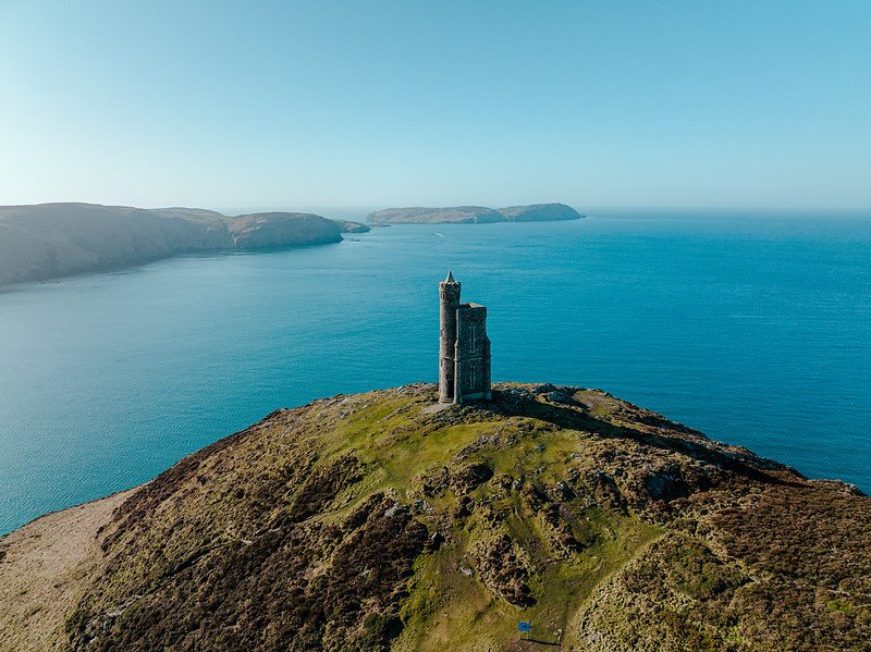
Peel Hill & Corrin's Tower – Climb Peel Hill for panoramic views over the town, castle and Irish Sea. Corrin’s Tower at the summit provides a clear viewpoint and a recognisable landmark.
Peel Coast Path & Glen Walks - Follow coastal paths or explore nearby glens for a mix of sea views, woodland and quieter walking routes just beyond the town.
Peel: A Viking Harbour Town
Peel began as a Viking settlement known as “Holmgarðr”, centred around the fortress on St Patrick’s Isle. Over time, it grew into an important fishing port and trading town, later becoming a popular Victorian seaside destination.
Today, that history is still visible in the harbour, the town layout and its strong maritime character, with fishing and local produce remaining part of everyday life.
- Viking Origins – Settlement dating back to the Norse period
- Fishing Heritage – Long-standing maritime traditions
- Victorian Revival – Growth as a seaside destination
Peel Coast Path
The Peel Coast Path follows the shoreline in both directions from the harbour, linking beach, headland and wider walking routes.
The route combines promenade sections with more rugged coastal paths, offering a mix of easy walks and longer options along the west coast.
- Flexible Routes – Short walks or longer coastal sections
- Varied Terrain – Promenade, beach and cliff paths
- Castle Views – Some of the best viewpoints on the island
Peel Castle
Set on St Patrick’s Isle, Peel Castle is one of the Isle of Man’s most significant historic landmarks, with origins dating back to the Viking era.
Expanded through the medieval period, the site includes fortress walls, towers and the ruins of St German’s Cathedral, all set against a dramatic coastal backdrop.
- Viking Foundations – Originally built as a Norse stronghold
- Medieval Expansion – Cathedral, towers and defensive walls
- Coastal Setting – One of the island’s most iconic views
Nearby: Around Peel & the West
Just beyond Peel, the surrounding countryside offers a mix of quiet rural stops, local produce and lesser-known historical sites. These nearby locations are easy to include as short detours, adding depth to the route without taking you far from the west coast.
From ancient trees and working farms to stories from the island’s wartime past, this area reveals a different side of the Isle of Man — slower, more local and often overlooked.
Ballacosnahan Elm
A centuries-old survivor, the Ballacosnahan Elm stands as one of the Isle of Man’s last great elm trees — a rare reminder of a landscape largely lost to disease elsewhere.
- One of the island’s oldest surviving trees
- A rare elm unaffected by widespread disease
- Set in peaceful countryside near St John’s
Ballacosnahan Wool & Farm Shop
The Ballacosnahan Wool & Farm Shop offers a genuine taste of Manx farming heritage, centred around the island’s distinctive Loaghtan sheep.
- Locally produced wool and traditional crafts
- Manx Loaghtan meat and farm produce
- Small-scale, authentic rural setting
Centre for WWI Internment
The Centre for WW1 Internment explores the story of Knockaloe Camp — once one of Britain’s largest internment camps during the First World War.
- Major WWI internment site with global significance
- Artefacts, letters and personal stories
- A lesser-known chapter of island history
On the Route: Peel to Port Erin
Heading south from Peel along the A27 coastal route, this section brings together wooded glens, upland viewpoints and a handful of unusual roadside stops. It’s a varied stretch where short detours reveal waterfalls, folklore and wide-open views above the west coast.
Most stops sit just off the main road between Glen Maye and Dalby, with a few inland diversions towards the southern hills. It’s best explored at a relaxed pace, allowing time to pause along the way.
Glen Maye Waterfall
~5 mins south of Peel (A27)
Glen Maye
is a peaceful woodland glen with one of the island’s most accessible waterfalls, set within dense trees and flowing streams.
- Short walk to a dramatic waterfall
- Woodland trails and footbridges
- Easy stop just off the main road
The Dalby Spook
~10 mins south of Peel (near Dalby)
The story of
Gef the Talking Mongoose
— known locally as the Dalby Spook — is one of the island’s strangest and most famous folklore tales.
- One of the Isle of Man’s most unusual legends
- Linked to a remote farmhouse
- A quirky and lesser-known stop
Dalby Mountain Nature Reserve
~15 mins south of Peel
Dalby Mountain
offers open upland scenery with some of the best coastal views on the west side of the island.
- Panoramic views across the Irish Sea
- Quiet walking routes and wildlife
- Peaceful upland setting
South Barrule Hillfort
~20 mins inland from Peel
South Barrule
is one of the island’s most important Iron Age sites, set high above the surrounding landscape.
- Ancient hillfort over 2,000 years old
- Elevated panoramic views
- Short but rewarding walk
Magnetic Hill
~25 mins south of Peel (A27 near Ronague)
Magnetic Hill
is a gravity illusion where vehicles appear to roll uphill when placed in neutral.
- A quick and unusual roadside stop
- Classic optical illusion
- Fun, short experience

Port Erin: Sheltered Bay, Coastal Views & Seaside Heritage
-
Port Erin is one of the most accessible and rewarding stops on the Isle of Man’s southwest coast. Whether you arrive for a short coastal stop or spend a few hours exploring, everything is easy to navigate, with beach, promenade and key sights all within walking distance.
Getting There
By Car (Scenic Coastal Route)
The most rewarding route follows the west coast before crossing into the south:Take the A27 from Peel towards Dalby
Continue onto the A36 (Sloc Road) via Round Table and Cronk ny Arrey Laa
Descend into Port Erin via the A31
Distance: 16 miles (26 km)
Drive time: 30–35 minutes
This is one of the island’s most scenic drives, with elevated views across the west coast.
Alternative Route (Better in Poor Weather)
Take the A1 to St John’s, then follow the A3 and A7 via Foxdale and Ballabeg
Distance: 17 miles (27 km)
Drive time: ~30 minutes
More sheltered and reliable if visibility is poor on the Sloc.
By Bus
No direct route from Peel
Travel via Douglas:
Bus 4 or 5 (Peel → Douglas)
Change to Bus 1, 1A, 2 or 2A (Douglas → Port Erin)
Total journey time: 1.5–2 hours
By Bicycle
The A36 Sloc Road offers a challenging but rewarding ride
Expect steep climbs and exposed sections
Approximate time: 1.5–2 hours
Parking in Port Erin
Port Erin Promenade Car Park – Best for beach access and seafront
Railway Station Car Park – Convenient for museum and town centre
Bradda Glen Car Park – Ideal for coastal walks and Bradda Head
Town Centre Parking – Mix of free and pay-and-display options
On-street parking – Available but limited in peak periods
Getting Around
Port Erin is compact and easy to explore on foot:
Beach, promenade and railway station all within 5–10 minutes walk
Coastal paths begin directly from the town
Ideal for a relaxed visit without needing to move your car
Best Time to Visit
Spring & Summer
Best for beach use, water activities and coastal walks
Calmer sea conditions in the sheltered bay
Livelier atmosphere along the promenade
Autumn & Winter
Quieter and more atmospheric
Strong coastal scenery and dramatic light
Ideal for walking and photography
How Long to Spend
Quick stop – 45–60 minutes (beach + promenade)
Half day – 2–3 hours (add coastal walk or museum)
Longer visit – 3–4+ hours (include Bradda Head and surrounding walks)
Practical Tips
The bay is sheltered, making it one of the best swimming spots on the island
Combine beach + promenade + coastal walk for an easy visit
Bradda Head walks start close to town — no need to drive
Works well as a key stop before The Sound and the southern coastline
On Foot: Coastal Walks from Port Erin
Port Erin connects directly to one of the most scenic stretches of the Isle of Man Coastal Path, where dramatic headlands, historic landmarks and quieter coastal landscapes come together. This is a place to slow down and explore beyond the town, with rewarding walks in both directions.
Isle of Man Coastal Path & Bradda Head
The Isle of Man Coastal Path passes through Port Erin, offering access to one of the island’s most dramatic coastal sections. Heading towards Bradda Head, the route follows high cliffs and open sea views, with a strong sense of space and exposure.
This stretch is ideal for a short walk or a longer coastal hike, with well-defined paths leading out of the bay and into more rugged terrain.
- Bradda Head Walk – One of the island’s most scenic short coastal routes
- Milner’s Tower – Distinctive landmark overlooking the bay
- Cliffs & Coves – Expansive views with quieter beaches below
North Bradda Mines: Coastal Industrial Heritage
Set along the cliffs near Bradda Head, North Bradda Mines are the remains of a once-thriving 19th-century mining site. Today, engine houses, shafts and stone structures sit quietly within the landscape, blending industrial history with coastal scenery.
Reached via the coastal path, the site offers a more rugged and atmospheric stop, combining history, walking and wide sea views.
- Historic Mine Ruins – Remains of lead and zinc extraction
- Cliffside Setting – Dramatic position above the sea
- Quiet & Atmospheric – A lesser-visited extension of the walk
Port Erin sits on the Isle of Man’s southwest coast, centred around a wide, sheltered bay backed by hills and open sea views. It feels immediately different to Peel — softer, more enclosed, and shaped around its beach rather than a working harbour.
Originally a small fishing settlement, Port Erin developed into one of the island’s key Victorian seaside resorts. That legacy remains in its promenade, railway connection and relaxed coastal atmosphere, making it one of the most accessible and easy-going stops on the route.
Sheltered Sandy Bay – One of the island’s best beaches, ideal for swimming and relaxing
Victorian Seaside Character – Promenade, railway and traditional coastal feel
Easy Coastal Access – A great base for walking, boat trips and exploring the south
What to See & Do
Port Erin Beach & Bay - A wide, sandy beach set within a sheltered bay, making it one of the safest and most popular spots for swimming on the island. Ideal for walking, relaxing or simply taking in the coastal views.
Promenade & Seafront - The promenade runs along the curve of the bay, lined with cafés, restaurants and small shops. It’s an easy place to slow down, with views across the water and a relaxed, traditional seaside feel.
Water Activities & boat trips - Port Erin is one of the best places on the island to get out onto the water.
Kayaking and paddleboarding in the calm bay
Boat trips along the coast or towards the Calf of Man
Opportunities to spot marine life and seabirds
Port Erin Railway Museum - Located at the end of the Isle of Man Steam Railway line, this small museum offers a look at the island’s railway heritage, with vintage locomotives, memorabilia and exhibits.
Coastal Walks & self-guided walks (downloads PDF) - Port Erin links directly to some of the island’s best walking routes, including sections of the coastal path. Self-guided town walks also provide a simple way to explore its history and surroundings.
Port Erin Golf Club - Set above the coastline, the course offers wide views over the bay and Irish Sea. Even if you’re not playing, the setting alone makes it worth noting.
Marine Biological Station - A quieter point of interest connected to the island’s marine research and coastal environment, adding another layer to Port Erin’s relationship with the sea.
The Sound: Cliffs, Currents & Open Sea
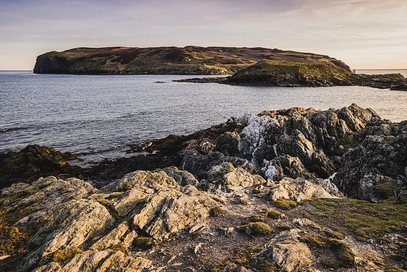
At the southwestern tip of the Isle of Man, The Sound is one of the island’s most dramatic coastal locations. Here, the land narrows and the sea dominates — with powerful tidal currents rushing between the mainland and the Calf of Man, a small island just offshore.
It’s a place defined by movement and exposure. Cliffs drop into fast-moving water, seabirds ride the wind, and the views stretch far beyond the coastline. Despite its wild setting, it’s also one of the easiest places to stop and take in the scale of the island’s landscape.
Powerful Tidal Waters – Fast-moving currents and swirling eddies between the island and Calf of Man
Cliff-top Views – One of the most dramatic and accessible viewpoints on the island
Wildlife & Open Sea – Seabirds, seals and wide coastal horizons
What to See & Do
Coastal Views & The Calf of Man - The main viewpoint looks directly across to the Calf of Man, separated by a narrow but fast-moving stretch of water. It’s one of the most iconic views on the island, with constant movement in the sea below.
Cliff-top Walks - Short walks lead along the cliffs in both directions, offering different angles on the coastline. Even a brief walk adds a sense of scale beyond the main viewpoint.
Wildlife Watching - The area is known for seabirds and marine life:
Seals are often visible along the shoreline
Seabirds circle the cliffs and headland
Occasional sightings of larger marine life offshore
Sound Cafe - A well-placed stop overlooking the water, offering indoor and outdoor seating with direct views across to the Calf of Man. A good place to pause and take in the setting.
Lighthouses & Coastal Landmarks - The waters around The Sound are marked by historic navigation points:
Calf of Man Lighthouse
Chicken Rock Lighthouse
Both reflect the importance of this stretch of sea for maritime navigation.
Sir Percy Cowley Memorial & Thousla Cross - Smaller but meaningful landmarks:
Sir Percy Cowley Memorial – Honouring a key figure in conservation
Thousla Cross – Commemorating a dramatic maritime rescue involving the schooner Jeaune St. Charles

On the Route: The Sound to Port St Mary
As the route rounds the southern tip of the Isle of Man, the landscape shifts dramatically. The gentler west coast gives way to exposed cliffs, fast-moving tidal waters and some of the island’s most striking coastal scenery.
This is one of the most rewarding sections of the journey, where several of the island’s standout locations sit close together — from heritage sites and traditional villages to cliff-top viewpoints and walking routes. It’s a place to slow down, step out of the car and take in the detail of the landscape.
Whether you choose a short stop at The Sound, a longer visit to Cregneash, or time on the coastal paths, this stretch offers a strong sense of place — where nature, history and open sea meet.
The Sound & Calf of Man
~15 mins from Port Erin • Allow 10–20 mins
At the southernmost tip, the
Calf of Man
sits just offshore, separated by fast-moving tidal waters.
- Views across to a protected wildlife island
- Strong tidal currents and dramatic seascapes
- One of the island’s most iconic viewpoints
Cregneash Folk Village
Next to The Sound • Allow 45–60 mins
Cregneash
is a preserved village offering a glimpse into traditional Manx life, with thatched cottages and working demonstrations.
- Living museum of 19th-century Manx life
- Traditional crafts and farming
- Scenic coastal setting
Spanish Head
Short walk from Cregneash • Allow 20–30 mins
Spanish Head
is a dramatic cliff-top viewpoint with sweeping views over the Sound and Calf of Man.
- Towering cliffs and exposed headland
- Part of the coastal walking route
- Excellent photography viewpoints
Raad ny Foillan Coastal Path
Runs through this section • Allow 20–60 mins (short walk)
Raad ny Foillan
links many of the island’s most scenic coastal stretches.
- 100-mile coastal walking route
- Well-marked and accessible in sections
- Includes Spanish Head and The Sound
The Chasms
Before Port St Mary • Allow 20–30 mins
The Chasms
are a series of deep coastal fissures carved into the cliffs, creating one of the island’s most striking natural features.
- Dramatic rock formations and narrow gorges
- Cliff-top paths with sea views
- Unique geological landscape
Port St Mary: Working Harbour, Coastal Walks & Maritime Heritage
-
Getting There
By Car
Port St Mary is well connected and easy to reach from across the island:From Port Erin – approx. 5 minutes via the A5
From Castletown – approx. 10 minutes via the A5
From Douglas – approx. 25–30 minutes via the A5
This section of the route follows the southern coastline, with open sea views and easy driving conditions.
By Bus
Regular bus services run between Douglas, Castletown and Port Erin
Port St Mary sits directly on the main southern route
Journey time from Douglas: ~40 minutes
By Train (Steam Railway)
Port St Mary is served by the Isle of Man Steam Railway
Scenic journeys run between Douglas, Castletown and Port Erin
A slower but memorable way to arrive.
Parking in Port St Mary
Port St Mary Harbour Car Park – Best for harbour views and seafront access
Railway Station Parking – Convenient for town centre and railway
High Street Car Park – Ideal for shops, cafés and village centre
Beach & Shore Road Parking – Limited spaces near coastal areas and walking routes
On-street parking – Available but can be limited in peak periods
Getting Around
Port St Mary is compact and easy to explore on foot:
Harbour, village centre and coastal areas within 5–10 minutes walk
Coastal paths begin directly from the village
Ideal for a relaxed stop without needing to move your car
Best Time to Visit
Spring & Summer
Best for coastal walks, boat trips and calmer sea conditions
Livelier atmosphere with more activity around the harbour
Autumn & Winter
Quieter and more atmospheric
Strong coastal scenery and changing light
Ideal for walking and photography
How Long to Spend
Quick stop – 45–60 minutes (harbour + short walk)
Half day – 1.5–3 hours (add coastal walk or heritage trail)
Longer visit – 3+ hours (combine with The Sound, Spanish Head or nearby sites)
Practical Tips
A quieter alternative to Port Erin, with a more local feel
Combine with The Sound and southern coastal stops for a fuller experience
Easy to include as a short stop or part of a longer day along the south coast
From Port St. Mary to Castletown
Leaving Port St Mary, the route turns north along the A5, where the coastline begins to soften and the landscape opens out into lower, gentler terrain. The rugged cliffs and exposed headlands of the south give way to wider views across farmland and shoreline, creating a quieter, more settled feel.
This is a short and easy drive, but one that marks a clear shift in character — from coastal drama to history and heritage. As you approach Castletown, the skyline changes again, with the outline of Castle Rushen and the harbour coming into view.
It’s a natural next step in the journey, moving from sea to story, where one of the island’s most historic towns begins to take shape.
Port St Mary sits quietly along the island’s southern coastline, centred around a traditional fishing harbour and framed by sheltered bays and open sea. Compared to Port Erin, it feels more local and less resort-like — a place shaped by everyday maritime life rather than tourism.
Originally a small fishing village, it grew during the 19th century as part of the island’s herring industry, with boatbuilding, trade and salvage all playing a role in its development. Today, that working heritage remains visible, with boats still using the harbour and a slower, more authentic coastal atmosphere.
Traditional Fishing Harbour – A working harbour with strong maritime character
Quieter Coastal Setting – Less busy than Port Erin, with a more local feel
Easy Access to Coastal Walks – Close to The Sound, Spanish Head and The Chasms (see above)
What to See & Do
Harbour & Village Centre – The focal point of Port St Mary, where fishing boats and small vessels still come and go. Walk around the harbour to take in the working maritime atmosphere and views across the water.
Beaches & Coastal Edge – A mix of small sandy bays and rocky shoreline offering quieter alternatives to nearby Port Erin, ideal for short walks, beachcombing or simply enjoying the sea views.
Fishing, Boat Trips & Marine Life – Opportunities to fish from the pier or rocks, take boat trips along the southern coast or towards the Calf of Man, and spot seabirds and seals along the shoreline.
Heritage Trail – A self-guided route linking harbour, historic buildings and coastal viewpoints, offering an easy and informative way to explore the village. Allow around 1–2 hours.
Alfred Pier & Coastal Views – A historic pier extending into the bay, providing wide views across the sea and back towards the village, with opportunities to spot wildlife.
Railway Station & Steam Railway – Part of the Isle of Man Steam Railway, offering a scenic and historic journey to Douglas or Castletown.
Golf Club – Set above the coastline, offering elevated views across the southern coast and surrounding countryside.
The Sound, Spanish Head & The Chasms (see above) – Easily reached from Port St Mary, these locations offer some of the island’s most dramatic coastal scenery, from cliff-top walks to striking rock formations.
TSS Mona's Queen III Anchor Memorial – A coastal memorial dedicated to those lost at Dunkirk in 1940, with the anchor facing out to sea as a place of reflection.
Castletown: Medieval Stronghold, Harbour & Manx History
-
Castletown is one of the Isle of Man’s most historically rich towns, but it’s also compact and easy to explore. Centred around Castle Rushen and the harbour, most key sights sit within a short walking distance, making it an ideal stop to explore at a relaxed pace.
Getting There
By Car
Castletown is well connected and easy to reach from across the island:From Port St Mary – approx. 10 minutes via the A5
From Port Erin – approx. 10–15 minutes via the A5
From Douglas – approx. 20–25 minutes via the A5
This is a straightforward coastal route with open views and easy driving conditions.
By Bus
Regular bus services run between Douglas, Port Erin and the south of the island
Castletown sits on the main southern route
Journey time from Douglas: ~30 minutes
By Train (Steam Railway)
Castletown is served by the Isle of Man Steam Railway
Direct connections to Douglas and Port Erin
A scenic and historic way to arrive directly into the town centre.
Parking in Castletown
Castle Rushen Car Park – Best for the castle and town centre
Castletown Harbour Car Park – Ideal for harbour views and waterfront walks
Old Grammar School Car Park – Convenient for historic sites and market square
Train Station Car Park – Useful for railway access and edge-of-centre parking
On-street parking – Available but can be limited during peak times
Getting Around
Castletown is compact and easy to explore on foot:
Castle, harbour and main attractions within 5–10 minutes walk
Flat and walkable layout
Ideal for a relaxed visit without needing to move your car
Best Time to Visit
Spring & Summer
Best for exploring the castle, harbour and coastal areas
Livelier atmosphere with cafés and attractions open
Good conditions for walking and sightseeing
Autumn & Winter
Quieter and more atmospheric
Ideal for exploring historic sites at a slower pace
Dramatic coastal light around the harbour and bay
How Long to Spend
Quick stop – 45–60 minutes (castle exterior + harbour)
Half day – 2–3 hours (castle interior, town and nearby sites)
Longer visit – 3–4+ hours (add Balladoole, Hango Hill or surrounding area)
Practical Tips
Castle Rushen is the focal point — start here and explore outward
Combine castle + harbour + Old House of Keys in one easy loop
Works well paired with Port St Mary or southern coastal stops
A strong history stop before continuing north towards Douglas
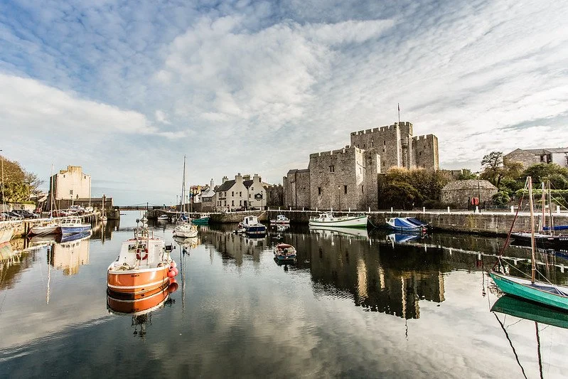
Castletown sits at the heart of the Isle of Man’s history, once serving as the island’s capital and centre of political life. Today, it remains one of the best places to understand the island’s past, with its medieval castle, historic buildings and harbour all within a compact and walkable setting.
Unlike the coastal resort feel of nearby towns, Castletown is defined by its heritage. The presence of Castle Rushen dominates the skyline, while the surrounding streets and harbour reflect centuries of governance, trade and maritime activity. It’s a place where the island’s story feels close and tangible.
Medieval Heritage – One of the most historically important towns on the island, centred around Castle Rushen
Compact & Walkable – Key landmarks all within a short distance of each other
Harbour & Coastal Setting – A mix of historic townscape and open views across Castletown Bay
What to See & Do
Castletown Town
Castle Rushen – One of the best-preserved medieval castles in Europe, with towers, halls and dungeons to explore, offering a deep insight into the island’s Viking, medieval and political history.
Old House of Keys – The former meeting place of the Isle of Man’s parliament, now a museum where you can explore the island’s political history through interactive exhibits and guided tours.
Castletown Harbour & Town Centre – A compact historic area centred around the harbour, ideal for walking between key landmarks, with views across the bay and a strong sense of the town’s maritime past.
The Nautical Museum – Located in a former sail loft by the harbour, showcasing Castletown’s maritime heritage, including shipbuilding, fishing and seafaring traditions.
Old Grammar School – Founded in 1701, this is the oldest surviving roofed building on the island, offering a glimpse into early education and Manx history.
Nearby & Around Castletown
Manx Aviation and Military Museum – Located at Ronaldsway Airport, featuring the Museum of the Manx Regiment and one of the most comprehensive collections dedicated to a British Army Light Anti-Aircraft unit.
Castletown Golf Links – One of the oldest golf courses in the British Isles, set along the coastline with wide views across the sea and surrounding landscape.
Silverdale Glen – A peaceful wooded valley just outside town, with walking paths, a stream and open green space, ideal for a short nature stop.
Scarlett Nature Discovery Centre – A scenic coastal area with views across Castletown Bay, combined with a visitor centre explaining the peninsula’s geology, quarrying history and fossil landscape.
Nearby: Around Castletown
Castletown was once the island’s capital and remains one of the Isle of Man’s most historically rich locations. While the town itself is compact, the surrounding area reveals layers of Manx history — from medieval strongholds and Viking sites to ancient burial grounds and quieter coastal viewpoints.
Many of these locations sit just a few minutes from the centre, making them easy to explore as short stops or combined into a relaxed half-day around Castletown.
Castle Rushen
In Castletown • Allow 60–90 mins
Castle Rushen
is one of the best-preserved medieval castles in Europe, standing at the heart of the town.
- Medieval fortress with towers, halls and dungeons
- Former royal residence and prison
- Panoramic views from the battlements
Hango Hill
Walk from Castletown • Allow 20–30 mins
Hango Hill
is a historic coastal viewpoint with links to Viking activity and later Manx history.
- Historic lookout above Castletown Bay
- Linked to Viking and later execution history
- Wide coastal views
Balladoole Heritage Site
~5 mins from Castletown • Allow 30–45 mins
Balladoole
is one of the island’s most important archaeological sites, with layers of history spanning thousands of years.
- Viking boat burial site
- Iron Age hillfort and early chapel remains
- Panoramic countryside and coastal views
Knock Rushen Burial Mound
On the edge of Castletown • Allow 10–15 mins
Knock Rushen
is a Bronze Age burial site dating back over 3,000 years.
- Ancient burial mound and archaeological site
- Evidence of early Manx rituals
- Quiet and lesser-known stop
Ronaldsway Battlefield & Derby Fort
~5 mins north of Castletown • Allow 15–25 mins
The
Battle of Ronaldsway
marked the end of Norse rule on the Isle of Man, while nearby
Derby Fort
reflects later Civil War history.
- Site of a key medieval turning point
- Links to Viking, Scottish and English rule
- Later Civil War defensive position
On the Route: Castletown to Port Soderick
Leaving Castletown and heading north along the A5, the route passes through the parish of Santon — a stretch shaped by folklore, motorsport heritage and quieter coastal viewpoints. It’s an easy drive, but one where a few well-chosen stops add depth to the journey.
From the traditions of the Fairy Bridge to hidden coastal forts and classic motorcycle collections, this section offers a mix of quick roadside stops and short detours before the route continues towards Douglas and Port Soderick.
Fairy Bridge
~5 mins from Castletown (A5 Santon) • Allow 5–10 mins
The
Fairy Bridge
is one of the island’s most well-known traditions — where visitors greet the “Little People” for good luck.
- A famous Manx folklore stop
- Notes and tokens left by visitors
- Still observed by TT riders and locals
Murray’s Motorcycle Museum
~2 mins from Fairy Bridge • Allow 20–40 mins
Murray’s Motorcycle Museum
houses a collection of classic bikes and racing memorabilia, reflecting the island’s deep connection to motorcycling.
- Vintage motorcycles from major manufacturers
- TT and racing heritage displays
- Compact and easy to visit
Cronk ny Merriu Fort
~10 mins from Santon (coastal detour) • Allow 30–45 mins
Cronk ny Merriu
is a coastal promontory fort overlooking Port Grenaugh, with roots in the Iron Age and later Norse occupation.
- Celtic Iron Age fort with Viking reuse
- Earthwork defences and settlement remains
- Wide views over the coastline and Irish Sea
Port Soderick: Coastal Walks, Hidden Beach & Victorian Echoes
Port Soderick sits just south of Douglas, where wooded glens meet a small, sheltered bay and rugged coastline. Once a lively Victorian seaside resort, it has since become a quieter, more atmospheric stop — known for its scenic walks, coastal views and traces of its past.
Today, the remains of pleasure grounds, old railway routes and coastal paths create a layered landscape. It’s less about a single attraction and more about the setting — a place to pause, walk and explore one of the island’s more understated coastal corners.
Hidden Coastal Setting – A secluded bay framed by cliffs, woodland and open sea
Victorian Heritage – Remnants of pleasure grounds, railway routes and a former resort
Great for Walking – Coastal paths, woodland trails and scenic viewpoints
What to See & Do
Coast & Walking
Marine Drive – A scenic coastal road passing above Port Soderick, offering elevated views across the Irish Sea with several places to stop and take in the landscape.
Coastal Paths & Cliff Walks – Follow sections of the Raad ny Foillan coastal path, with routes ranging from easy shoreline walks to more exposed cliff-top paths with wide sea views.
Port Soderick Beach – A small, sheltered beach tucked between cliffs, ideal for a quiet stop, short walk or simply taking in the sound of the sea.
Beachcombing & Rock Pools – At low tide, explore the shoreline for shells, sea glass and small rock pools where marine life can often be spotted.
Heritage & Local Interest
Victorian Pleasure Grounds – Remnants of the area’s past as a popular seaside resort, where gardens, a pier and attractions once drew visitors from across the island.
Former Railway Line Walk – A converted trail following the old Douglas to Port Soderick railway line now a peaceful route through woodland and along the coast.
Isle of Man Steam Railway (Port Soderick Station ) – A nearby stop on the historic steam railway line, offering a nostalgic journey between Douglas, Castletown and Port Erin.
Crogga Valley Railway – A small-scale miniature railway nearby, featuring a narrow-gauge steam train and adding a quieter, niche point of interest.
Activities & Experiences
Walking & Hiking – One of the best ways to explore the area, with routes linking coastal views, woodland paths and nearby glens.
Fishing from Shore & Rocks – A popular local spot for sea fishing, particularly along the rocks and deeper water areas around the bay.
Wildlife Spotting – Look out for seabirds, seals and occasional marine life, especially along quieter stretches of the coastline.
-
Getting There
By Car (Easiest Option) – Located just south of Douglas along the A5. Turn off onto Port Soderick Road and follow it down to the coast. The final stretch is narrow and winding.
From Douglas – Around 10 minutes (3 miles / 5 km) via the A5, making it an easy short detour from the main route.
By Bus – Services between Douglas and Castletown/Port Erin (routes 1, 1A, 2, 2A) stop along the A5. From there, it’s a short but steep walk down to the bay.
On Foot (Coastal Path) – Accessible via the Raad ny Foillan coastal path from Douglas or from the south, offering one of the most scenic approaches.
Parking
Port Soderick Beach Car Park – Small car park near the shoreline, best for direct beach and coastal path access.
Roadside Parking – Limited on-street parking along Port Soderick Road.
Layby Parking (A5) – Some visitors park along the main road and walk down, though care is needed due to traffic and limited space.
How Long to Spend
30–60 minutes – Enough for a short walk, beach stop or quick explore.
1–2 hours – Ideal if combining coastal walks, beachcombing or exploring the old railway path.
Half Day – If linking with Douglas coastal walks or extending further along the coastline.
Best Time to Visit
Spring & Summer – Best for calmer seas, clearer views and enjoying the beach or coastal paths.
Autumn – Quieter, with strong coastal atmosphere and good walking conditions.
Winter – More dramatic scenery, though paths can be exposed and weather conditions change quickly.
Low Tide – Best for beach access, rock pools and exploring the shoreline.
Visiting Tips
Access Road – The road down to the bay is narrow, so take it slowly and be prepared for limited passing places.
Facilities – Very limited on-site, so it’s best to arrive prepared.
Footwear – Coastal paths can be uneven and exposed, so sturdy footwear is recommended.
Route Planning – Works best combined with Douglas, Santon or Castletown as part of a wider route.
From Port Soderick to Douglas
Leaving Port Soderick, the route continues north along the A5, following the coastline back towards Douglas. It’s a short but scenic stretch, where glimpses of the sea open up between wooded slopes and the road gradually reconnects with the island’s capital.
Along the way, the landscape feels more settled and familiar again, marking the transition from the quieter southern coastline back into a more active part of the island. If time allows, you can follow sections of the old Marine Drive, a historic coastal route offering elevated views back across the bay and towards the southern cliffs.
As you approach Douglas, the coastline becomes more developed, with the long promenade coming into view — a clear signal that the journey is drawing to a close.
End of Chapter: Return to Douglas
Arriving back into Douglas completes the final section of the route, bringing the journey full circle. From here, the island’s capital offers a natural place to pause, reflect or extend your stay.
After travelling through coastal villages, open landscapes and historic towns, Douglas feels both familiar and different — a reminder of where the journey began, now seen with a fuller understanding of the island as a whole.
End of Road Trip: Isle of Man Complete
This route has taken you around the Isle of Man as a complete loop — connecting coastlines, landscapes and places that together define the island.
From the sheltered bays of the east to the wide, open north, through the quieter west coast and into the dramatic southern headlands, each section reveals a different character. What makes the journey stand out is how quickly those changes unfold — often within just a few miles.
The route is designed to be flexible. It can be followed in full, explored in sections, or adapted depending on how you like to travel. Whether you’ve focused on history, scenery, walking or simply the drive itself, the experience builds as you move around the island.
Many of the most memorable moments aren’t always the headline stops, but the quieter stretches in between — coastal roads, hidden viewpoints and unexpected pauses along the way.
This guide provides the structure. The journey itself is yours to shape.
Uncover More Map
The Uncover More map highlights key points of interest, scenic viewpoints, hidden gems, and much more along the recommended route. To make the most of it, use the map in conjunction with the destination information, and explore additional options in the area you’re visiting to discover even more experiences.
If your iPhone doesn’t load via the Google Map App via the button, check out the Help page for how to update your phone or copy and paste the link into your browser: https://bit.ly/iom-uncover
Isles & Islands > Last updated: 30 March 2026
Some links may earn Uncover Britain a small commission at no extra cost to you. This helps support the ongoing creation, review and presentation of our road trip guides.
Route information and listings are provided for general guidance only. Always use your preferred navigation system and check official websites to confirm suitability, opening times and the latest details before travelling.
Our guides are reviewed regularly and supported by a mix of editorial research and digital tools to help keep content clear and up to date. If you spot anything that needs updating, we’re always glad to hear from you.