


20 miles (32km) with drive time approx. 45 mins
Connecting from Dhoon Glen - total 27 miles (44km) with drive time approx. 60 mins
Customisable and Live Navigation via Google Maps –
click here:
Or use the link to jump to the destinations in the guide below
Maughold →
Ramsey →
Point of Ayre →
Jurby
The West Coast & Southern Return
Continuing north from the eastern coastline, the character of the Isle of Man begins to shift as the landscape opens out and the sense of space becomes more pronounced. This section follows the island’s northern edge, where longer stretches of coastline, fewer settlements and wider horizons create a quieter, more expansive feel.
From Maughold, the route passes through Ramsey before reaching the Point of Ayre, the island’s northernmost tip. From here, the journey continues west across the open plains around Jurby, setting up the transition towards the west coast.
While this chapter follows the coastal route, the island’s interior offers a more dramatic alternative via the TT Mountain Road between Douglas and Ramsey. This is covered separately in the TT Route chapter, allowing you to experience it either alongside or independently from the main journey
How to Spend Your Time
This section offers a blend of history, coastal beauty, and scenic countryside. Maughold is perfect for discovering ancient Viking crosses and rugged coastal walks, while Ramsey combines Victorian charm, a bustling harbour, and nearby nature reserves. Head north to the Point of Ayre, the island’s northernmost tip, where the lighthouse and nature reserve provide stunning sea views and wildlife spotting. In Jurby, explore the island’s motorsport and aviation heritage, visit the Jurby Transport Museum, or take a quiet coastal walk along Jurby Bay.
-
Morning: Maughold & Ramsey
Maughold Church & Viking Crosses – Start the day with a visit to this historic site, home to ancient Viking cross-slabs and beautiful coastal views.
Maughold Head Walk – Take a short clifftop walk for stunning views over the Irish Sea.
Ramsey Promenade & Harbour – Drive to Ramsey, stroll along the Victorian promenade, and visit the Ramsey Heritage Centre to learn about the town’s history.
Afternoon: Point of Ayre & Jurby
Point of Ayre Lighthouse & Nature Reserve – Head to the northernmost tip of the Isle of Man to see sweeping sea views, a historic lighthouse, and the wild dunes of the Ayres Nature Reserve.
Jurby Transport Museum – Explore a quirky collection of vintage buses, cars, and motorcycles, a great stop for motor enthusiasts.
Jurby Bay & Beach Walk – End your day with a peaceful coastal walk at Jurby Bay, enjoying panoramic views of the Irish Sea.
-
Day 1: Exploring Maughold & Ramsey
Maughold – Visit Maughold Church, famous for its Viking cross-slabs and coastal views. Take a scenic walk along Maughold Head for breathtaking seascapes.
Raven Glen – Enjoy a peaceful woodland walk with native flora and birdlife.
Ramsey – Explore Ramsey Promenade and Ramsey Heritage Centre for local history.
Milntown Estate – Tour this historic manor house, stroll through the gardens, and enjoy tea at the café.
Day 2: Point of Ayre & Jurby
Point of Ayre – Visit the northernmost point of the Isle of Man, featuring a historic lighthouse and sweeping coastal views.
Ayres Nature Reserve – Take a nature walk through sand dunes and heathland, perfect for birdwatching and photography.
Jurby – Stop at Jurby Church, then visit the Jurby Transport Museum, home to vintage buses, motorcycles, and classic cars.
Jurby Bay – End your day with a relaxing beach walk, taking in the views of the Irish Sea.
Day 3: Deeper Exploration of Ramsey & Surrounding Areas
Lewaigue & Ballure Reservoir – Take a morning countryside walk near Ramsey for beautiful rural scenery.
Ramsey’s Mooragh Park – Enjoy a lake walk, cycling trails, or a relaxing picnic in this scenic park.
Albert Tower Walk – Hike up to this historical tower, offering panoramic views over Ramsey and the northern coastline.
Evening in Ramsey – Explore the town’s cafés and restaurants, or take a relaxing stroll along the promenade at sunset.
-
Days 1-3: Follow the 3-day itinerary above.
Day 4: More Remote Beauty & Relaxation
Glen Auldyn & Tholt-y-Will Glen – A beautiful nature walk inland, leading through woodland trails, waterfalls, and hidden streams.
Blue Point Beach & Jurby Coastline – A lesser-visited beach ideal for quiet reflection and scenic walks.
Ramsey Golf Course or Local Market Visit – Enjoy a round of golf with coastal
Maughold Lighthouse: A Remote Beacon on the Northern Coast

Perched just offshore on Conister Rock, Maughold Lighthouse is one of the Isle of Man’s most striking coastal landmarks — a solitary structure set against the open sweep of the Irish Sea. Located around 3 kilometres northeast of Maughold village, it sits slightly apart from the coastline, adding to its sense of isolation and quiet drama.
First established in 1914 to replace an earlier 19th-century light, the current lighthouse is a simple white-painted tower, built for function rather than ornament. Its steady presence reflects the importance of this stretch of coastline, where changing weather and rocky outcrops have long made navigation challenging.
While Maughold Lighthouse itself is not open to the public due to its offshore location, visitors can view the lighthouse from various vantage points along the coastline near Maughold village. Access to Conister Rock, where the lighthouse is located, is restricted and requires special permission.
A distinctive offshore lighthouse set on its own rocky outcrop
A working navigational beacon with a recognisable flashing pattern
Wide coastal views from nearby cliffs and headlands
What to See & Do:
View the lighthouse from coastal paths and viewpoints near Maughold village
Look out for its characteristic white flash every 5 seconds
Explore the surrounding coastline for elevated vantage points
Take in the contrast between the exposed rock and open sea
-
. By Road (Driving from Douglas to Maughold)
✔ Route: Take the A2 Coast Road north from Douglas through Onchan, Laxey, and Baldrine, following signs for Maughold.
✔ Distance & Time: Approximately 14 miles (22 km), around 30 minutes by car.
✔ Final Stretch: Turn onto Dreemskerry Road, which leads to Maughold village and the church.2. By Bus (Douglas to Maughold)
✔ Bus Route:
Take Bus 3 or 3A from Douglas to Ramsey, which stops near Maughold.
✔ Journey Time: Around 45 minutes.
✔ Bus Stop: The nearest stop is along the A2 road, approximately 1 mile from Maughold village, requiring a 15-20 minute walk down country lanes to the church and key sites.
Where to Catch the Bus in Douglas:
Douglas Bus Station (Lord Street).
Additional stops along the A2 coast road through Onchan and Laxey.
3. By Train (Manx Electric Railway from Douglas to Maughold)
✔ Route:
Board the Manx Electric Railway (MER) at Derby Castle Station in Douglas.
Take the northbound tram toward Ramsey.
Disembark at Maughold Halt – a request stop just outside the village.
✔ Journey Time: Approximately 50 minutes.
✔ Walking Distance: The Maughold Halt stop is about 15 minutes on foot from the village.
Why Take the Train? – The Manx Electric Railway offers a scenic coastal journey, passing through Laxey and providing fantastic views of the coastline before arriving near Maughold.
Best Way to Get to Maughold?
✔ By Car – The fastest and most direct option with convenient parking at the church and coastline.
✔ By Train – The most scenic journey, though requiring a short walk from Maughold Halt.
✔ By Bus – The cheapest public transport option, but requires walking from the A2. -
Car Parking in Maughold:
Maughold Church Car Park – Located near the churchyard, ideal for those visiting the Celtic crosses and historic sites.
Maughold Head Car Park – Provides access to coastal walks and scenic viewpoints.
Limited on-road parking in the village.
From Maughold to Ramsey
Leaving Maughold, the route follows the coastline north towards Ramsey, where the landscape opens out and the headlands soften into a broader bay. Along the way, a series of quieter stops reveal layers of history shaped by both ancient settlement and the sea.
Maughold – Norse Roots & Viking Legacy
Maughold is one of the Isle of Man’s strongest links to its Viking past, shaped during the Norse occupation between the 9th and 13th centuries. The name itself is believed to derive from Old Norse, reflecting the influence of settlers who established communities along this exposed northern coastline.
The parish is home to one of the island’s most important collections of early Christian and Viking crosses, many carved with intricate Norse designs and runic inscriptions — rare physical evidence of a culture blending pagan and Christian traditions.
Local legend tells of Maughold himself, a Viking warrior who converted to Christianity and became a bishop, symbolising the island’s transition from Norse rule to a Christian society.
On the Route: Coastal History Between Maughold and Ramsey
As the route curves north towards Ramsey, the coastline becomes more rugged and exposed, revealing layers of history shaped by both ancient settlement and maritime events. These quieter stops sit just off the main drive, offering a chance to pause, walk and take in the landscape beyond the road.
Gob ny Rona: Iron Age Fort on a Wild Headland
Set on a dramatic coastal outcrop near Ramsey, Gob ny Rona is one of the Isle of Man’s most atmospheric prehistoric sites.
- A coastal Iron Age fort with over 2,000 years of history
- Dramatic headland setting with expansive sea views
- A rewarding coastal walk from Maughold Head
S.T Cevic Shipwreck
The remains of the S.T Cevic shipwreck lie along Ramsey Bay, revealed at low tide.
- Visible remains of a 20th-century shipwreck
- A quiet, atmospheric coastal stop
Ramsey: Harbour Town, TT Corner & Northern Coast Gateway

Set on the island’s northern coast, Ramsey feels more open and expansive than much of the Isle of Man — shaped by its wide bay, working harbour and long-standing role as a coastal hub. With roots in Norse settlement and a later history as a key port, it’s a place where maritime life still plays a visible role.
Today, that mix defines the town. Victorian buildings sit alongside active quaysides, the beach stretches out along the bay, and during TT season, Ramsey becomes one of the most iconic viewing points on the course.
The Town
Ramsey’s centre is compact but characterful, built around a series of squares and streets that reflect its Victorian growth and earlier importance as a port town.Ramsey’s centre is compact but characterful, built around a series of squares that reflect both its civic importance and its later growth as a seaside town.
Parliament Square – The focal point of the town and one of the most famous TT viewing locations, where bikes sweep through at speed. The square is framed by Georgian and Victorian buildings, including the prominent Ramsey Courthouse
St. Paul's Square & St. Paul's Church – A quieter historic area centred around St Paul’s Church, with elegant architecture and a strong sense of Ramsey’s social and community life
Shops, cafés and pubs – A mix of independent spots and traditional venues that give the town a relaxed, lived-in feel
Harbour & Coast
Running alongside the town, Ramsey’s harbour and coastline provide its strongest sense of place — open, active and shaped by both trade and the sea.
Ramsey Harbour & Swing Bridge – A working harbour where fishing boats and yachts come and go, with the distinctive 1892 swing bridge connecting both sides
Queen's Pier – A long Victorian pier stretching into the bay, currently under restoration but still one of the town’s defining landmarks
Ramsey Beach & Promenade – A wide sandy beach with open views across the Irish Sea, ideal for walking and taking in the scale of the coastline
Mooragh Lake Park – A large park just behind the coast, offering walking paths, water views and space to relax

Nearby & Worth the Detour
Just outside the centre, a few quieter spots add depth to a visit and are easy to include as short detours.
Milntown Estate and Gardens – A historic country house with gardens and woodland walks just outside Ramsey
Grove Museum – A preserved Victorian house offering a glimpse into domestic life on the island from the 19th to 20th century
The Fynoderee Distillery – A local craft distillery producing small-batch spirits inspired by Manx folklore, using traditional methods and local ingredients

-
✔ By Car
Take the A15 Coast Road north, which joins the A2 into Ramsey.
Distance: About 5 miles (8 km).
Driving Time:10-15 minutes.
Parking in Ramsey: Available in Mooragh Park Car Park, Ramsey Quay, and along the promenade.
✔ By Bus
Take Bus 3 or 3A northbound from the A2 near Maughold.
Journey Time:10-15 minutes.
Bus Stop in Ramsey:Ramsey Bus Station near the town center.
✔ By Train (Manx Electric Railway)
Board the Manx Electric Railway (MER) at Maughold Halt.
Journey Time:20 minutes.
Arrival Station:Ramsey Tram Station, a short walk from the town centre.
-
Car Parking in Ramsey, Isle of Man
Ramsey has several parking options, including free and pay-and-display car parks, as well as on-street parking in key areas of the town.
1. Free Public Car Parks
✔ Mooragh Park Car Park (Best for Leisure & Outdoor Activities)
Located near Mooragh Park and Ramsey Beach.
Ideal for walks, the boating lake, and coastal views.
Free parking available.
✔ Ramsey Swimming Pool Car Park (Best for Central Access)
Located next to the swimming pool on Queen’s Promenade.
Close to the town centre and beach area.
Free parking available.
✔ Ramsey Bus Station Car Park (Best for Shopping & Town Centre)
Situated next to Ramsey Bus Station on West Quay.
Convenient for shops, restaurants, and local businesses.
Free parking available but can get busy.
✔ Ramsey Courthouse Car Park (Best for Short Visits & Quick Stops)
Located at Ramsey Courthouse in Parliament Square.
Close to the market area and town centre.
Limited spaces, but free parking is available.
2. Pay-and-Display Car Parks
✔ Ramsey Promenade Car Park
Located along Queen’s Promenade.
Ideal for beach access and town centre visits.
Pay-and-display system in place.
✔ Ramsey Harbour Car Park (West Quay)
Situated near Ramsey Quay and the harbour area.
Good for access to cafés, shops, and scenic walks.
Pay-and-display parking.
3. On-Street Parking
✔ Parliament Square & Market Place
Short-stay parking available (often time-restricted).
Convenient for quick shopping trips or visiting cafés and local businesses.
✔ Bowring Road & Other Side Streets
Some on-street parking available in residential areas near the town centre.
Check for any parking restrictions or time limits.
Best Car Parking Options in Ramsey
For town centre shopping & quick stops: Ramsey Courthouse, Bus Station, or Parliament Square.
For longer stays & outdoor activities: Mooragh Park or Ramsey Swimming Pool Car Park.
For the beach & promenade: Queen’s Promenade Car Park.
Most parking in Ramsey is free, but some pay-and-display areas apply, particularly near the harbour and promenade.
Ramsey to the Northern Coast
Leaving Ramsey, the route begins to quieten almost immediately, with the town giving way to open shoreline and low-lying coastal landscapes. This stretch feels slower and more natural, where the focus shifts from harbour life to wetlands, wildlife and wide views across the Irish Sea.
Just beyond the edge of town, a series of nature-rich stops offer a different perspective on the island — less about landmarks, more about landscape and atmosphere.
Poyll Dooey Nature Reserve: Wetlands on the Edge of Ramsey
Located just outside town along the banks of the Sulby River, Poyll Dooey Nature Reserve is one of the island’s most accessible and rewarding natural spaces — a quiet contrast to Ramsey’s busier centre.
This is a place shaped by water and changing tides, where salt marsh, woodland and meadow come together to create a rich and varied habitat. It’s particularly good for birdlife, with wading birds feeding along the mudflats and seasonal wildlife appearing throughout the year.
- A peaceful wetland reserve just minutes from Ramsey
- A mix of salt marsh, woodland and open meadow habitats
- One of the best easy-access wildlife spots in the north
Ramsey Marine Nature Reserve: Coastal Walks & Open Horizons
As the road continues along the coast, you pass through the Ramsey Marine Nature Reserve, a protected stretch of shoreline known for its rich marine life and unspoilt coastal scenery.
This section of coast is best experienced slowly, either by stopping along the roadside or walking sections of the beach. The landscape shifts between sand, rock and tidal pools, with wide views that feel increasingly remote as you move away from town.
- A protected coastal area rich in marine and birdlife
- Quiet shoreline walks with expansive sea views
- A chance to experience the island’s wilder coastline
Continuing to Point of Ayre
Beyond the nature reserves, the landscape becomes even more open and elemental. The coastline flattens, the views stretch further, and the sense of exposure increases as you approach the island’s northernmost point.
This final stretch towards Point of Ayre feels distinctly different — quieter, wider and more remote — leading to one of the Isle of Man’s most striking and unexpected coastal landscapes.
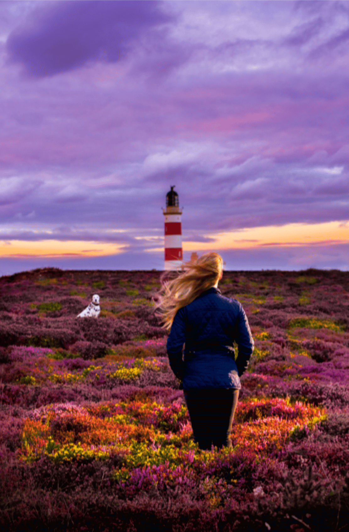
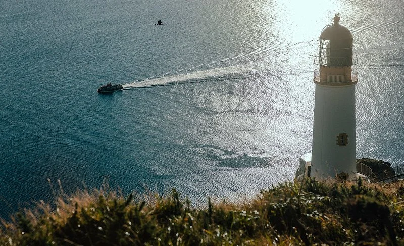
Point of Ayre: The Isle of Man’s Northern Edge
At the very northern tip of the Isle of Man, the Point of Ayre feels exposed, remote and elemental — where shifting dunes, open sea and wide skies define the landscape. Bordered by the Irish Sea and the North Channel, this is a place shaped by wind, tides and time.
It’s less about a single attraction and more about the experience of being here — a mix of lighthouse heritage, protected nature reserves and raw coastal scenery that feels far removed from the rest of the island.
Point of Ayre Lighthouse
Marking the island’s northernmost point, the distinctive red and white Point of Ayre Lighthouse has stood here since 1818. Designed by Robert Stevenson, it has guided vessels through this challenging stretch of water for over 200 years, where tides and shifting sandbanks have long made navigation difficult.
- The oldest lighthouse on the Isle of Man (built 1818)
- Designed by the renowned Stevenson lighthouse family
- Set in one of the island’s most exposed coastal locations
The Ayres & Point of Ayre Reserves
Stretching along the northern coastline, The Ayres National Nature Reserve and the nearby Manx BirdLife Point of Ayre National Reserve protect one of the island’s most important coastal ecosystems — a landscape of dunes, heathland and open habitats rich in wildlife.
- Extensive dune system and coastal heathland
- Rich birdlife including waders, terns and migratory species
- One of the Isle of Man’s key protected habitats
MWT Cronk y Bing Nature Reserve
The MWT Cronk y Bing Nature Reserve offers a quieter stretch of coastline, where heathland, dunes and shoreline combine to create a varied and wildlife-rich landscape.
- Rare dune and heathland ecosystem
- Excellent birdwatching and coastal wildlife spotting
- Part of the Raad Ny Foillan coastal walking route
Getting There & Parking
The Point of Ayre sits at the end of the A10, with a straightforward route north from Ramsey. The final stretch becomes increasingly open and exposed, with long straight roads leading towards the lighthouse and coastline.
Access is simple, but facilities are limited — this is a remote area, so it’s worth arriving prepared, especially in changeable weather.
- Point of Ayre Car Park – Direct access to the lighthouse, beach and coastal paths
- A10 Lay-bys – Small roadside stops for viewpoints and short coastal detours
- Cronk y Bing Access – Track south of Lhen Bridge with parking near the shoreline
Point of Ayre to Jurby
Leaving the Point of Ayre, the landscape begins to shift again — from exposed dunes and open sea to flatter, more agricultural ground. The sense of remoteness softens, replaced by long straight roads, low fields and big skies that stretch across the northern plain.
This section is less about defined stops and more about the feeling of space. It’s a quieter drive, where the coastline gradually gives way to inland farmland, with only occasional glimpses back towards the sea.
There aren’t any major headline stops along this stretch, but it’s worth slowing down briefly to take in the changing landscape — particularly where the dunes transition into open fields. Otherwise, it’s best enjoyed as a simple, uninterrupted drive towards Jurby.
Jurby: Open Coastlines & Aviation Heritage

Continuing west from the Point of Ayre, the route reaches Jurby — a quieter stretch of the northern plain where wide skies, open farmland and long sandy beaches define the landscape. This is a place that feels spacious and unhurried, with the coastline never far from view.
Once settled by the Vikings and later shaped by farming and fishing, Jurby retains a strong sense of its past. Today, it blends rural character with unexpected highlights — from historic churches to aviation heritage and coastal walks along one of the island’s most open shorelines.
Wide sandy beaches and open coastal scenery
A mix of rural heritage and WWII aviation history
A quieter, less visited part of the Isle of Man
What to See & Do:
Visit the Jurby Transport Museum for classic vehicles and military exhibits
Explore St Patrick’s Church dating back to the 12th century
Walk along Jurby Beach and the surrounding coastline
Combine with nearby airfield and coastal stops
-
From Point of Ayre to Jurby
✔ By Car (Fastest Route)
From Point of Ayre, take the A10 south towards Bride.
Continue through Bride village, following signs for Jurby.
After approximately 1 mile, turn right onto the A14 (Jurby Road).
Follow the A14 westward, which takes you directly to Jurby.
Distance: 5 miles (8 km).
Driving Time: 10-15 minutes.
✔ By Bicycle or On Foot
Cycling is a great option, with the A10 and A14 offering a quiet, flat route.
Walking is possible but takes around 1.5-2 hours from Point of Ayre.
✔ By Bus (Not Direct)
No direct bus from Point of Ayre to Jurby.
The nearest bus route runs from Ramsey to Jurby, requiring a trip to Ramsey first.
From Douglas to Jurby
✔ By Car (Fastest Route)
Take the A3 north from Douglas to Ramsey (~30 minutes).
At Ramsey, turn left onto the A9 towards Ballaugh.
At Sandygate crossroads, turn right onto the A14 (Jurby Road).
Follow signs to Jurby, arriving in about 15 minutes from Ramsey.
Distance: 18 miles (29 km).
Driving Time: 35-40 minutes.
✔ By Bus
Take Bus 5 from Douglas to Ramsey (~1 hour).
Transfer to Bus 18 in Ramsey, which runs to Jurby (~30 minutes).
Total journey time: ~1.5 hours.
✔ By Bicycle
Cyclists can take the A3 Mountain Road or A2 Coast Road to Ramsey, then follow the A14 to Jurby.
Car Parking in Jurby
✔ Jurby Transport Museum Car Park – Located near the museum, airfield, and village centre, with ample free parking.
✔ Jurby Church Car Park – Ideal for those exploring the historic church and surrounding countryside.
✔ Jurby Airfield Parking – Limited parking near the former RAF base and motorsport events.
Jurby Airfield: RAF Heritage & Open Runways
Just inland from the coast, Jurby Airfield is one of the Isle of Man’s most significant aviation sites, originally established in 1939 as an RAF training base. During World War II, thousands of aircrew trained here before joining Bomber Command, with aircraft including Wellingtons, Ansons and Spitfires operating from its runways.
Today, the airfield remains active in a different way — its wide, open runways now host general aviation, motorsport events and occasional air displays, giving the site a unique mix of historic significance and modern-day use.
- Former WWII RAF training base with strong aviation heritage
- Active site hosting aviation events and motorsport
- Large open landscape with visible wartime remnants
Passages Shipwreck: A Hidden Relic in the Sands
Along the coast near Jurby, the remains of the Passages shipwreck lie partially buried in the sand, revealed only at low tide. Wrecked here in 1931 after running aground, the vessel was returning from a successful herring voyage when it met its fate in the shifting coastal shallows.
Today, the exposed structure appears and disappears with the tide — a subtle but evocative reminder of the island’s fishing heritage and the risks once faced at sea.
- A partially exposed shipwreck visible at low tide
- A link to the island’s fishing and maritime history
- A quiet, atmospheric coastal stop
Jurby to Spooyt Vane Waterfall
Leaving Jurby, the route turns south and the landscape begins to change once again — from flat coastal plains to the rising ground of the island’s interior. Fields give way to glens and wooded valleys, with the road becoming more enclosed as it approaches the hills above Sulby.
Tucked just off the main route, Spooyt Vane Waterfall is one of the Isle of Man’s more unexpected natural features — easy to miss if you don’t know it’s there. Located near the A14 between Sulby and Tholt-y-Will, the waterfall sits just a short walk from the roadside, where a small parking area and footpath lead down into the glen.
It’s a brief but worthwhile detour, offering a contrast to the open landscapes around Jurby — a shaded, more intimate setting where water cuts through the rock and woodland surrounds the falls.
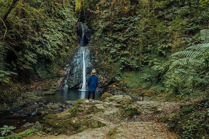
The Glen Mooar valley stretches from the main road connecting Peel to Kirk Michael southwards, leading to a small plantation beyond the Spooyt Vane ('White Spout') in Manx Gaelic) waterfall. Spooyt Vane Waterfall is a breathtaking sight just beyond the glen's boundary, however, visitors are permitted to view it by the owner. Please be respectful. This majestic waterfall cascades in three distinct stages from the ledge above, gracefully descending through the surrounding trees and rocky walls to the tranquil pool below. Tucked away in a secluded hollow, the waterfall offers a serene ambience, allowing visitors to immerse themselves in its natural beauty before continuing their journey through the glen.

Tholt-y-Will Glen: Woodland Drives & Hidden Valleys
Set in the hills above Sulby, Tholt-y-Will Glen offers a quieter, more enclosed landscape — a contrast to the open coastlines further north. Winding roads, woodland and streams combine to create one of the Isle of Man’s most peaceful inland routes.
This is a place to slow down — whether driving through, stopping for a short walk, or exploring deeper into the glen’s trails and surrounding hills.
A Scenic Drive Through the Glen
One of the best ways to experience Tholt-y-Will is simply to drive through it. Narrow country lanes wind between woodland, streams and open hills, with views that unfold gradually rather than all at once.
- Start near Sulby Reservoir and follow the glen road south
- Quiet, winding lanes with very little traffic
- Connects through to the A18 Mountain Road
Walking Trails & Woodland Routes
For those exploring on foot, the glen offers a mix of shorter woodland walks and longer routes linking into the surrounding landscape, including Sulby Reservoir and the higher ground beyond.
- Short woodland paths suitable for a gentle walk
- Longer hikes connecting to the reservoir and uplands
- Quiet, less-visited walking routes
Getting There & When to Visit
Tholt-y-Will Glen sits inland between Ramsey and the central hills, with easy access from both the north and south. The entrance is signposted, with parking available near the glen and reservoir.
- From Ramsey or Sulby – follow the A3 towards Sulby Reservoir
- From Douglas – take the A1 to Ballaugh, then the A14 inland
- Parking available near the glen entrance
Uncover More Map
The Uncover More map highlights key points of interest, scenic viewpoints, hidden gems, and much more along the recommended route. To make the most of it, use the map in conjunction with the destination information, and explore additional options in the area you’re visiting to discover even more experiences.
End of This Section
This northern stretch brings together some of the Isle of Man’s most contrasting landscapes — from exposed coastline and shifting dunes to open farmland and quieter inland glens. It’s a section defined by space and subtlety, where the experience comes as much from the journey as the stops themselves.
As the route turns away from the north, the landscape begins to change once again — leaving behind the flat plains and heading towards a more defined coastline.
Next: The West Coast & Southern Return
The next section follows the island’s western and southern edges, where the character shifts noticeably. The coastline becomes more dramatic, with cliffs, bays and coastal roads replacing the wide openness of the north.
From Peel to Port Erin and around to Castletown and Port Soderick, this part of the journey brings together some of the Isle of Man’s most recognisable seaside towns, historic harbours and sweeping coastal views — a more varied and often more visually striking stretch of the route.
If your iPhone doesn’t load via the Google Map App via the button, check out the Help page for how to update your phone or copy and paste the link into your browser: https://bit.ly/iom-uncover
Isles & Islands > Last updated: 30 March 2026
Some links may earn Uncover Britain a small commission at no extra cost to you. This helps support the ongoing creation, review and presentation of our road trip guides.
Route information and listings are provided for general guidance only. Always use your preferred navigation system and check official websites to confirm suitability, opening times and the latest details before travelling.
Our guides are reviewed regularly and supported by a mix of editorial research and digital tools to help keep content clear and up to date. If you spot anything that needs updating, we’re always glad to hear from you.