

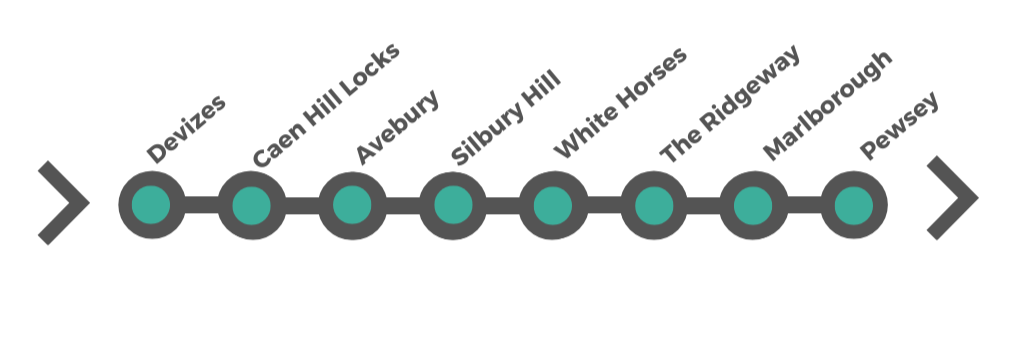
53 miles (85 km) with drive time approx. 1 hour 50 minutes
Devizes > Caen Hill Locks > Avebury > Silbury Hill > White Horses > The Ridgeway > Marlborough > Pewsey
Part 2 - North Wessex Downs & Ancient Landscapes
Leaving the market towns of West Wiltshire behind, the landscape opens out into the rolling chalk hills and wide valleys of the North Wessex Downs, one of southern England’s most distinctive and historic landscapes. Recognised as a National Landscape (formerly an Area of Outstanding Natural Beauty), this region is defined by sweeping downland, ancient trackways and some of the most remarkable prehistoric monuments in Britain.
This section of the journey weaves together three interconnected stories.
The first is the engineering achievement of the Kennet and Avon Canal, where the remarkable flight of locks at Caen Hill Locks and the historic Crofton Beam Engines reveal the ingenuity behind one of Britain’s most ambitious waterways.
The second story stretches much further back in time. The vast stone circle at Avebury, the mysterious mound of Silbury Hill, and ancient burial chambers scattered across the hills form one of the richest prehistoric landscapes in Europe.
Finally, the chalk hills themselves shape the character of the Downs. Along the ridges runs The Ridgeway, often described as Britain’s oldest road, while the famous Wiltshire White Horses cut into the hillsides provide some of the most recognisable landmarks in the region.
Together these landscapes create a journey through thousands of years of human history set against the wide horizons and quiet valleys of the North Wessex Downs.
How to Spend Your Time Here
This road trip explores Wiltshire’s historic landscapes, from Avebury’s prehistoric wonders and Caen Hill Locks to the market towns of Devizes and Marlborough and the villages of Aldbourne, Ramsbury, Great Bedwyn, and Pewsey. Whether you have one day or a week, these itineraries offer a flexible way to experience stone circles, historic houses, canal walks, and rural charm at your own pace.
-
Ideal for a short visit covering the most significant sites.
Morning in Avebury: Explore the Avebury Stone Circle, visit the Alexander Keiller Museum, and walk to Silbury Hill and West Kennet Long Barrow.
Midday in Marlborough: Stroll through the historic market town, visit Marlborough College, and enjoy lunch in one of its historic coaching inns.
Afternoon at Caen Hill Locks & Devizes: Walk along the Caen Hill Locks, visit the Wiltshire Museum in Devizes, and explore the town’s historic streets.
-
Day 1 – Avebury & Marlborough
Spend the morning exploring Avebury, including the stone circle, Silbury Hill, and West Kennet Long Barrow.
Have lunch in Avebury’s Red Lion Pub, one of the only pubs inside a stone circle.
Drive to Marlborough, stroll along the Broadway, visit Marlborough College, and explore the Merchant’s House.
Day 2 – Devizes & Caen Hill Locks
Start in Devizes, visit the Wiltshire Museum, and learn about the town’s medieval roots.
Enjoy a walk along the Caen Hill Locks, one of Britain’s most impressive canal staircases.
Visit Wadworth Brewery for a tasting and brewery tour.
Day 3 – Pewsey, Ramsbury & Aldbourne
Drive through the scenic Pewsey Vale, stopping at the Pewsey White Horse for a countryside walk.
Explore the villages of Ramsbury and Aldbourne, both steeped in history.
Visit Great Bedwyn, an ancient settlement along the Kennet & Avon Canal.
-
Day 1 – Calne & Avebury
Start in Calne, visiting the Heritage Centre to learn about the town’s connection to the discovery of oxygen.
Drive to Avebury, explore the stone circle, Silbury Hill, and West Kennet Long Barrow.
Day 2 – Marlborough & Pewsey Vale
Spend time in Marlborough, exploring Marlborough College and The Merchant’s House.
Visit Pewsey, see the White Horse, and walk along the Kennet & Avon Canal.
Day 3 – Devizes & Caen Hill Locks
Visit Devizes, explore the Wiltshire Museum, and see the Devizes Castle ruins.
Walk along the Caen Hill Locks, enjoying the scenic canal views.
Day 4 – Aldbourne & Ramsbury
Discover Aldbourne, known for its role in World War II as a training ground for Easy Company (Band of Brothers).
Explore Ramsbury, visiting Holy Cross Church and enjoying a village walk.
Day 5 – Great Bedwyn & Savernake Forest
Spend the morning in Great Bedwyn, exploring its historic canal locks.
Visit Savernake Forest, a former royal hunting ground with ancient trees.
-
Day 1 – Calne & Cherhill White Horse
Visit the Calne Heritage Centre and learn about the town’s role in the discovery of oxygen.
Walk up to the Cherhill White Horse and explore the Lansdowne Monument.
Day 2 – Avebury & Prehistoric Wiltshire
Spend the morning at Avebury, visiting the stone circle, Silbury Hill, and West Kennet Long Barrow.
Explore the Alexander Keiller Museum and enjoy a countryside walk.
Day 3 – Marlborough & Savernake Forest
Tour Marlborough College, explore the Merchant’s House, and browse the market.
Take an afternoon walk in Savernake Forest, home to some of Britain’s oldest oak trees.
Day 4 – Devizes & Caen Hill Locks
Explore Devizes, visiting the Wiltshire Museum and the Market Place.
Take a Kennet & Avon Canal boat trip or walk the Caen Hill Locks towpath.
Day 5 – Aldbourne & Ramsbury
Visit Aldbourne, known for its role in World War II history and the Band of Brothers.
Drive to Ramsbury, see Holy Cross Church, and walk through the village’s scenic streets.
Day 6 – Great Bedwyn & Pewsey Vale
Explore Great Bedwyn, walk along the canal locks, and visit St Mary’s Church.
Spend the afternoon in Pewsey Vale, visiting the Pewsey White Horse and exploring the surrounding countryside.
Revisit a favourite spot, enjoy a countryside walk, or spend a relaxed morning in Marlborough before heading home.
Devizes – Historic Market Town, Museum & Canal Heritage
Devizes is one of Wiltshire’s most characterful market towns, known for its handsome Market Place, rich architectural heritage and strong links to both the prehistoric landscape of Wessex and the Kennet & Avon Canal. With around 500 listed buildings, Devizes has an impressive historic core and is often regarded as one of the county’s most attractive towns.
The town has medieval origins, although there was earlier Roman settlement in the area. Devizes Castle was first built in the 11th century, and although little now survives above ground, traces of the original mound, moat and keep can still be seen. Over the centuries Devizes grew into an important market and coaching town, and today it remains a lively centre with museums, independent shops, cafés and cultural venues.
Its position also makes it a useful base for exploring the wider prehistoric and canal landscapes of this part of Wiltshire.
• Attractive historic market town with a striking medieval layout
• Excellent museum covering Stonehenge, Avebury and prehistoric Wessex
• Good base for Caen Hill Locks and the Kennet & Avon Canal (Read more below)
What to See and Do
Wiltshire Museum – one of the best museums in the region, with outstanding displays on the Stonehenge and Avebury World Heritage Site, including remarkable prehistoric gold.
Market Place – the heart of Devizes and one of the town’s most attractive historic spaces, lined with handsome buildings, shops and cafés.
Devizes Castle remains – see the earthworks and surviving traces of the original Norman castle site.
Roundway Down Iron Age Hill Fort – open downland with far-reaching views and a layered military and archaeological history. See the accordion for more.
Devizes White Horse – a modern chalk horse created to mark the Millennium.
Kennet and Avon Canal Museum – located at Devizes Wharf, this small museum explains the history of the canal, its construction, trade, restoration and life on the waterways. It adds useful context before or after visiting the locks.
Kenavon Boat Trips – for a different perspective on the canal, Kenavon Boat Trips offers boat trips from Devizes, allowing visitors to experience the Kennet & Avon Canal from the water rather than just from the towpath.
Drews Pond Nature Reserve – a peaceful spot for walking trails and wildlife close to the town.
Hillworth Park – a pleasant Victorian park with a café, aviary and landscaped grounds.
Wharf Theatre – a small independent theatre with a varied programme.
Palace Cinema – for a classic evening out in town.
Food and Drink
• Wharf Canal Trust Café – set in the historic bonded warehouse beside the canal museum.
• Caen Hill Café– a handy stop if visiting the locks.
• Bear Hotel – a historic coaching inn on the Market Place and a well-known Wadworth pub.
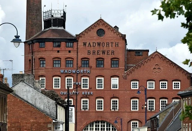
Visit the Wadworth Brewery visitor centre in the original Victorian brewery based in Devizes. The Tower Brewery, built in 1885, is a real landmark in the town. Here you can sample their famous 6X beer and meet the Shire horses that still deliver to pubs in the town today. The Visitor Centre at Wadworth Brewery offers an engaging experience for those interested in learning about the brewing process and the history of the brewery. The centre provides guided tours where visitors can explore the various stages of brewing, from the raw ingredients to the finished product. Guided tours typically include visits to the brewhouse, fermentation room, and the iconic Wadworth shire horses. The shire horses play a traditional role in delivering beer to local pubs, and visitors may have the opportunity to meet them. Wadworth Brewery is known for its commitment to traditional brewing methods. The tours showcase the use of traditional brewing equipment and techniques that have been passed down through generations.
-
How long to visit
Allow 1–2 hours to explore the town centre and museum. Add more time if also visiting Caen Hill Locks.Getting there / finding it
Devizes lies in central Wiltshire, around 11 miles (18 km) east of Chippenham and close to the A361 and A342. It does not have its own railway station, so most visitors arrive by car or bus.Parking
• Central Car Park (SN10 1AH) – about 162 spaces
• The Wharf Car Park (SN10 1EA) – about 106 spaces
• Station Hill Car Park (SN10 1BZ) – about 226 spaces
• Caen Hill Car Park (SN10 1RF) – about 45 spacesAll are useful depending on whether you are exploring the town centre or heading straight to the locks.
-
Fought on 13 July 1643, the Battle of Roundway Down was one of the most decisive Royalist victories of the English Civil War. The battle took place on the high chalk downland just north of Devizes, after Parliamentarian forces under Sir William Waller attempted to trap the Royalists in the town.
At the time, Devizes was being held by Royalist troops led by Lord Hopton. Waller’s Parliamentarian army had advanced into Wiltshire and believed it could defeat the Royalists before reinforcements arrived. However, Royalist cavalry under Sir Ralph Hopton and Lord Wilmot moved quickly to relieve the town, leading to a confrontation on the open downs above Devizes.
The battle is particularly remembered for the dramatic collapse of the Parliamentarian cavalry. As Royalist horsemen charged across the high ground, many of Waller’s troops were driven towards the steep escarpment at Bloody Ditch, where some fell to their deaths while others were cut down in retreat. The defeat was devastating for Parliament’s forces in the west.
Roundway Down was significant because it secured Wiltshire for the Royalists and strengthened their position across much of south-west England during this phase of the war. Today the landscape still offers sweeping views across the surrounding countryside, and although little visible evidence of the fighting remains, the site is one of the most important Civil War battlefields in Wiltshire.
Leaving Devizes, the route heads west out of town towards one of the most striking canal landscapes in England. Caen Hill Locks lies just 2 miles (3 km) from the centre of Devizes, and the drive usually takes 5–10 minutes.
As the town gives way to the edge of the canal, the landscape opens out into the long flight of locks climbing the hillside. This is where the Kennet & Avon Canal becomes one of the great engineering spectacles of the journey, with narrowboats, towpaths and wide views across the Wiltshire countryside.
Caen Hill Locks – One of Britain’s Great Canal Landmarks

Just outside Devizes, Caen Hill Locks is one of the most impressive sights on the Kennet and Avon Canal. The famous flight forms part of the canal route between Bristol and London and is celebrated for its dramatic staircase of locks climbing the hillside west of Devizes. The canal was completed in 1810 to designs by engineer John Rennie, and Caen Hill became one of its greatest engineering achievements.
The locks are not just historic; they are also one of the best places to experience the canal in action. Narrowboats rise and fall through the chambers, side ponds help manage water levels, and the long stepped line of locks creates one of the most distinctive canal landscapes in England. It is a place to walk, pause, watch boats working through the flight and appreciate the scale of early 19th-century engineering.
• One of the most spectacular lock flights on the Kennet & Avon Canal
• A striking piece of historic canal engineering with boats, towpaths and wide views
• Easy to explore on foot, with café, parking and waterside walks nearby
What to See and Do
• Walk the lock flight – follow the towpath alongside the famous stepped sequence of locks and watch boats moving through the chambers.
• See the main 16-lock flight – this is the best-known section and the most visually dramatic part of Caen Hill.
• Look out for side ponds and canal engineering features – these helped conserve water and are part of what makes Caen Hill historically important.
• Visit the Welcome Hub / Admiral boat – a useful place for information, local walks and background on the locks.
• Stop at Caen Hill Café – a good waterside break if you are walking the locks.
• Explore Jubilee Woodland – a short walk from the canal with trails and views over the wider landscape.
• Continue along the towpath towards Devizes Wharf – an easy extension if you want a longer walk linking the locks with the town.
-
How long to visit
Allow 1–2 hours for a relaxed visit, which is the Canal & River Trust’s own suggested timeframe. Add longer if walking further along the towpath towards Devizes or spending time at the café.How to get there / best way to visit
Caen Hill Locks is best reached by car from Devizes. The main visitor parking is the Canal & River Trust car park off Marsh Lane, with sat nav postcode SN10 1RF. From there, it is easiest to explore on foot along the towpath, either taking a short stroll for the views or walking more of the flight for the full effect. The towpath is open year-round.Parking
• Canal & River Trust Car Park, The Locks, Rowde, Devizes, SN10 1RF – main car park for visiting the flight; pay and display, £3 all day.Useful to know
• The locks can take 5–6 hours to traverse by boat, so if you are lucky enough to see boats working through the full flight, it is worth pausing to watch.
• Toilets are available for customers of the local café/pub.
From Caen Hill Locks, the route leaves the canal valley and heads deeper into the North Wessex Downs, where the story shifts from Georgian engineering to one of the richest prehistoric landscapes in Britain, centred on Avebury, Silbury Hill and the ancient tracks of the chalk downs.
Nearby Detour – Bowood House & Gardens
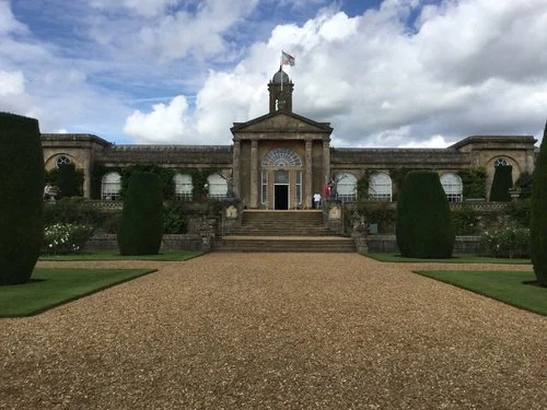
Image copyright: Bowood House & Gardens
Before the route moves fully into the ancient landscapes of the North Wessex Downs, a worthwhile detour leads to Bowood House and Gardens. Set between Chippenham and Calne, Bowood combines a grand Georgian house with beautifully designed gardens and sweeping parkland.
The house was bought in 1754 by the 1st Earl of Shelburne, who extended and remodelled it over the following decades. Bowood is also known for its place in scientific history: it was here, in one of the house’s rooms, that Joseph Priestley discovered oxygen on 1 August 1774.
The gardens are among Bowood’s main highlights. The Italian-inspired terrace gardens create a formal setting beside the house, while beyond them lies parkland landscaped by Capability Brown, with a curving lake, sloping lawns and mature trees. Further embellishments followed in the 1780s, when cascades, grottoes and a hermit’s cave were added around the lakeside. In late spring and early summer, the estate is especially well known for its long Rhododendron Walk.
Bowood makes a rewarding contrast to the canal and prehistoric sites nearby, adding art, landscape design and country house history to this part of the route.
The drive to Avebury from Caen Hill Locks is around 11 miles (18 km) and usually takes 20–25 minutes, following quieter roads out of the canal valley and into a very different landscape of rolling downs, wide skies and ancient earthworks.
This marks a clear shift in the journey. The story moves away from Georgian engineering and market towns into one of the richest prehistoric landscapes in Britain, where vast stone circles, burial mounds and ancient trackways have shaped the hills for thousands of years.
Avebury – Stone Circle Village in the Heart of Ancient Wessex

Avebury is one of the most remarkable prehistoric sites in Britain. Unlike Stonehenge, where the stones stand apart within a managed monument landscape, Avebury is woven into everyday village life. Roads, cottages and fields sit within and around the vast circle, creating a place where ancient history and the modern landscape exist side by side.
Built during the Neolithic period, Avebury forms part of a much wider ceremonial landscape that includes Silbury Hill, Windmill Hill, West Kennet Long Barrow, The Sanctuary and West Kennet Avenue. Together these monuments form one of the most important prehistoric landscapes in Europe and are part of the Stonehenge and Avebury World Heritage Site.
Today Avebury is one of the best places to experience the ancient landscape of Wessex at close quarters. You can walk among the stones, follow footpaths across the downs and explore a setting that still feels deeply connected to the rhythms of the land.
• The largest prehistoric stone circle in Britain
• Ancient stones, village streets and open countryside all in one place
• Part of a wider prehistoric landscape including Silbury Hill and ancient burial sites

What to See and Do
• Avebury Stone Circle – walk among the standing stones and around the great earthwork that surrounds the village.
• Avebury Manor Garden – a peaceful National Trust garden in the centre of the village.
• Alexander Keiller Museum – displays prehistoric finds from the Avebury landscape and explains the excavation of the monument.
• St James’s Church – the historic parish church standing within the circle itself.
• Village walks – wander through the village lanes and footpaths linking the stones, church and manor.
• West Kennet Avenue – traces of the ancient stone avenue that once linked Avebury with the wider ceremonial landscape.
• The Sanctuary – the site of a prehistoric stone and timber circle at the end of West Kennet Avenue, marked out today to show its original layout.
• Windmill Hill – one of the most important Neolithic causewayed enclosures in Britain, lying just outside Avebury and helping reveal the great antiquity of this ceremonial landscape.
• Silbury Hill viewpoint – continue a short distance to see the great prehistoric mound nearby. Read more below.
• West Kennet Long Barrow – a notable Neolithic burial chamber a short drive or walk from Avebury.
-
How long to visit
Allow 1.5 to 2 hours for the stone circle and village, or longer if also visiting the museums, Silbury Hill or West Kennet Long Barrow.Getting there / finding it
Avebury lies on the A4361, around 8 miles (13 km) west of Marlborough and 11 miles (18 km) north-east of Devizes.Parking
• National Trust Avebury Car Park (SN8 1RF) – main visitor car park for the stone circle, museum and villageThe National Trust car park is the easiest place to start and is within easy walking distance of the main sites.
Explore the North Wessex Downs’ Ancient Landscape
This section of the route passes through one of the most important prehistoric landscapes in Europe — where ancient monuments, burial mounds and ceremonial sites are spread across open countryside.
Together, these sites form one of Britain’s most remarkable prehistoric landscapes — often quieter and more immersive than Stonehenge, yet just as significant.
With Stonehenge typically around £25 per person, visiting just one or two additional sites in this area can quickly make an English Heritage membership worthwhile.
Annual membership starts from £53 — with 15% off using code AFFEH1526 until 31.12.2026.
Membership often pays for itself in just 2–3 visits, especially in this concentrated landscape.
Get 15% Off MembershipJust north of Avebury, a short detour leads to the Hackpen Hill White Horse, one of Wiltshire’s most striking chalk figures. Cut into the hillside in 1838, the horse stretches across the chalk slope and is best viewed from the surrounding roads and footpaths. The hilltop also offers wide views across the North Wessex Downs, making it a rewarding viewpoint stop when exploring the Avebury landscape. Visitors can park nearby at Hackpen Hill and walk a short distance onto the downs for the best perspective of the figure and the surrounding countryside.
Leaving Avebury, the route stays within the same extraordinary prehistoric landscape but shifts from stones you can walk among to a monument best understood at a distance. Silbury Hill lies just 1.5 miles (2.4 km) south of Avebury, and the drive takes only 5 minutes via the A4.
Although close by, it offers a different experience. Where Avebury invites exploration on foot through a village threaded with standing stones, Silbury Hill rises as a vast, mysterious earth mound beside the road — monumental, isolated and still not fully understood. Together, the two sites show the scale and ambition of Neolithic Wiltshire, and make clear that this was not a single monument, but an entire sacred landscape.
Silbury Hill – Monumental Prehistoric Mound in the Avebury Landscape
Silbury Hill is the largest artificial prehistoric mound in Europe and one of the great mysteries of the Avebury landscape. Built between about 2470 and 2350 BC, it rises dramatically from the valley floor and is best experienced as part of the wider ceremonial landscape around Avebury, rather than as a stand-alone stop.
Unlike Avebury, Silbury Hill is not a site you climb or enter. The monument is protected, and the best way to visit is to stop briefly at the viewing area or combine it with a longer walk linking Avebury, West Kennet Avenue and the surrounding prehistoric sites. English Heritage notes that there is a viewing area next to the car park, and that visitors cannot walk on the hill itself in order to protect the monument.
What to See and Do
• View Silbury Hill from the designated area – the mound is most impressive when seen from a little distance, rising unexpectedly from the flat valley floor.
• Walk to Waden Hill viewpoint – National Trust guidance highlights this as a good place to appreciate both Silbury Hill and the wider Avebury landscape.
• Combine it with the wider prehistoric landscape – Silbury Hill works especially well alongside Avebury, West Kennet Avenue and West Kennet Long Barrow, all within the same remarkable landscape.
• Pause for photographs and orientation – this is less about a long visit and more about appreciating the scale, mystery and setting of one of Britain’s most extraordinary prehistoric monuments.

Image copyright: National Trust
Wiltshire White Horses – Chalk Figures on the Downs
Scattered across the chalk hills of Wiltshire are a series of striking hillside figures known as the Wiltshire White Horses. Cut into the bright chalk beneath the grass, these large horse shapes have become iconic features of the county’s landscape. Many date from the 18th and 19th centuries and were created as local landmarks or symbols of pride for nearby villages.
Travelling east from Silbury Hill, a few of these white horses appear on the hillsides of the Downs. They are best appreciated from a distance, where the sweeping curves of the figures stand out against the green chalk slopes
• Distinctive chalk hillside figures unique to Wiltshire’s landscape
• Scenic viewpoints across the North Wessex Downs
• A chance to see historic local landmarks created over 200 years ago
The Cherhill White Horse is the closest to this route and the easiest to visit from the Avebury area. Carved into the hillside below Lansdowne Monument, the horse dates from 1780 and can be seen clearly from the surrounding countryside.
Further along the Downs near the village of Alton Barnes lies the Alton Barnes White Horse, another striking example cut into the chalk hillside. The horse overlooks the wide Pewsey Vale and sits close to the ancient route of the The Ridgeway, which continues east across the chalk downs.
Both sites are short scenic detours from the main route and offer wide views across the surrounding countryside, making them worthwhile stops before continuing towards the Ridgeway and Marlborough.
-
How long to visit
Allow 15–30 minutes for viewpoints and photographs, or longer if walking on the surrounding downs.How to find them
Cherhill White Horse lies just southeast of Calne on the A4 between Avebury and Marlborough.
Alton Barnes White Horse is located south of Pewsey within the Vale of Pewsey.Parking
Cherhill White Horse Car Park (near Cherhill Down, SN11 8UU) provides easy access and views of the figure.
For Alton Barnes White Horse, park in Alton Barnes village (SN8 4LB) and walk up onto the downs for the best viewpoint.
The Ridgeway – Britain’s Oldest Road Across the Downs

Running along the high chalk ridge of the Downs, The Ridgeway is often described as Britain’s oldest road. This prehistoric route has been used for more than 5,000 years, linking communities across southern England long before modern roads existed. Travellers chose the high ground to avoid the dense forests and marshy valleys below, creating a natural corridor across the landscape.
Today the Ridgeway is a long-distance walking and riding trail, stretching for around 87 miles (139 km) from Wiltshire to Buckinghamshire. In the North Wessex Downs it offers sweeping views over rolling chalk hills, wide valleys and ancient farmland — a landscape that feels remarkably unchanged.
• One of Britain’s oldest roads, used for over 5,000 years across the chalk downs
• Sweeping views across the North Wessex Downs National Landscape
• Surrounded by prehistoric sites including hill forts, burial mounds and ancient trackways
Along the Downs surrounding the Ridgeway are several important prehistoric hill forts, including Beacon Hill, Liddington Hill and Fosbury Camp. These elevated sites offered strategic viewpoints across the valleys and helped control ancient routes across the landscape. Later Roman roads also crossed these hills, continuing the long tradition of travel through the Downs.
Further east along the Ridgeway lie some of the most famous prehistoric monuments in Britain, including the Uffington White Horse and the Neolithic chambered tomb known as Wayland’s Smithy. Together they form part of a remarkable ancient landscape that stretches across the chalk hills of southern England.
-
How long to visit
Allow 30 minutes to 1 hour for a short walk and views, or longer if following part of the trail.Where to access the Ridgeway
Several access points exist across the North Wessex Downs. A convenient nearby access point is at Barbury Castle, where paths lead directly onto the Ridgeway.Parking
Barbury Castle Car Park (SN4 0QH) provides easy access to both the Ridgeway and the Iron Age hill fort, with wide views across the surrounding countryside.Good to know
The Ridgeway is a National Trail used by walkers, cyclists and horse riders. Surfaces vary from chalk tracks to grassy paths, so sturdy footwear is recommended if exploring beyond the viewpoint areas. -
Aldbourne Circular Route: This 12-mile circular route in the north Wiltshire Downs, just 5½ miles (9km) southeast of the centre of Swindon, is suitable for walkers, horse riders and cyclists. The route mainly follows broad tracks through rolling downland countryside rich in history from prehistoric to recent times. The route is waymarked with ‘Ridgeway Circular Route’ waymarks.
Ashbury Circulars: The Ashbury Circular Main walk is 7¾ miles (12½ km) with a shortcut reducing it to 6 miles (9½ km) - allow 4 hours (3 hours for shortcut route). The Ashbury Circular Short Walk is 2½ miles (4 km) – allow 1¼ hours
These walks are within the North Wessex Downs Area of Outstanding Natural Beauty. They start on The Ridgeway and take you through classic chalk countryside with wonderful views of rolling downland and the Thames Valley. They include the attractive spring line village of Ashbury at the foot of the scarp and provide some fascinating historical and natural features to explore.
Bishopstone Circular Walk: This circular walk is 4½ miles (7¼ km) long - allow 2 hours. The walk is within the North Wessex Downs Area of Outstanding Natural Beauty and starts from the small, picturesque, spring-line village of Bishopstone at the foot of the downs in Wiltshire about 5½ miles (9km) east of Swindon. It takes you through a lovely coombe up onto the downs and along a stretch of The Ridgeway before descending the scarp slope and returning to the start via the hamlet of Idstone.
Liddington Hill Literary circular walk: Follow in the footsteps of great writers who found inspiration in this landscape on this 4.5 miles walk. Allow at least 2.5 hours. Follow a route used by seemingly forgotten poet Charles Hamilton Sorley (1895-1915). He studied at Marlborough College from 1908 to 1913 and his experiences on the downs inspired poems such as Barbury Castle. (Sorley’s memorial stone lies further west along The Ridgeway, near Ogbourne St George).
Leaving The Ridgeway, the route descends from open chalk downland into the more settled landscape around Marlborough. The drive is short, but the change in character is noticeable: ancient trackways and sweeping hilltop views give way to a handsome market town with broad streets, old coaching inns and a long history as a stopping place on the route east and west through Wiltshire.
This transition works well because Marlborough feels like a natural pause after the prehistoric landscapes and high downs. After barrows, chalk figures and ridge-top panoramas, the town introduces a more domestic scale — part historic high street, part old road-route hub — while still sitting close to the ancient landscape that surrounds it.
Marlborough – Broad High Street, Old Coaching Town & Downland Gateway

Image copyright: Marlborough Town Council
Marlborough is one of Wiltshire’s most appealing market towns, sitting between the ancient landscapes of the North Wessex Downs and the old east–west route of the A4. Its famously broad High Street, lined with handsome old buildings, coaching inns, independent shops and cafés, gives the town an immediate sense of scale and character. Today it remains a lively shopping and market centre, while still feeling rooted in its long history.
The town has medieval origins and grew in importance as a market and coaching stop on the main route between London and Bath. Marlborough is also known for The Merchant’s House, one of the finest surviving 17th-century middle-class houses in England, and for St Peter’s Church, a historic building now used as a community and arts venue. Within the grounds of Marlborough College lies the mysterious Merlin’s Mound, an ancient mound long associated with local legend.
• One of Wiltshire’s most attractive historic market towns
• Wide High Street with shops, cafés, inns and old buildings
• Good base for nearby downs, Savernake Forest and Crofton Beam Engines
What to See and Do
• High Street – stroll along one of the widest high streets in the country, lined with historic buildings, shops and places to eat.
• Merchant's House – a beautifully restored 17th-century house with remarkable period features and decorative interiors.
• Hilliers Yard and Hughenden Yard – two small historic courtyards tucked just off the High Street, home to independent boutiques, galleries and cafés. They offer a quieter corner of Marlborough and are perfect for browsing local crafts and gifts.
• St Peter’s Church – a 15th-century church with strong local history, now serving as a community and arts venue; tower tours sometimes run for wider views over the town.
• Marlborough College and Merlin’s Mound – the college grounds contain the ancient mound linked by tradition to Merlin. The mound is not generally a full visitor attraction, but it adds to the town’s sense of mystery and antiquity.
• Independent shops and cafés – Marlborough is especially good for browsing, with a stronger retail feel than many small Wiltshire towns.
• Market days – Marlborough remains a market town, with regular markets adding to the atmosphere of the High Street.
Rick Stein at Marlborough provides a taste of Cornwall in the Wiltshire countryside serving the best fresh and sustainable Cornish seafood.
• Savernake Forest – just outside town, this ancient woodland offers a different landscape of long straight drives, veteran trees and quieter walks.
• Crofton Beam Engines – a worthwhile nearby heritage stop if continuing east towards Great Bedwyn and Pewsey.
• West Wood – about 4 miles (6 km) from Marlborough, this beautiful woodland is especially popular in spring when the forest floor fills with bluebells. It is also crossed by the Wansdyke Path, an ancient earthwork route that can be followed on longer walks.
• Marlborough White Horse – carved into Grantham Hill, this chalk horse can be seen when exploring the surrounding downs or following parts of the White Horse Trail.
-
How long to visit
Allow 1–2 hours for a walk along the High Street and main sights, or longer if visiting The Merchant’s House and stopping for lunch.Getting there / finding it
Marlborough lies on the A4, between Avebury and Hungerford, and works well as a natural stop after the prehistoric landscapes of the downs. It is also close to Savernake Forest and the eastern side of this chapter.Parking
Wiltshire Council lists both short- and long-stay parking in Marlborough. Useful central options include:
• George Lane Car Park – central and convenient for the High Street
• Hyde Lane Car Park – useful for longer stays
• Kennet Place Car Park – another central option near the town centreFor The Merchant’s House, there is also short-stay parking on the High Street and long-stay parking behind Waitrose at SN8 4BY.
-
Marlborough played a role in the English Civil War (1642–1651) as the town's strategic location made it a focal point for military activities during this turbulent period.
In 1642, Marlborough's tranquillity was shattered by the outbreak of the English Civil War. The Seymours, loyal to the King, held the Castle, while the town sided with Parliament. With King Charles based in nearby Oxford, Marlborough posed a challenge. Described as "the most notoriously disaffected" town in the region, its location was deemed unsuitable for a garrison, presenting difficulties for the King.
To address this, King Charles dispatched Lord Digby, who left Oxford with four hundred horsemen on 24 November 1642. Upon arrival, Digby opted for parley, allowing the town's inhabitants to fortify and gather roughly seven hundred poorly armed men. In response to Digby's overture, the town declared that the King, in a non-hostile manner, would be welcomed, but surrendering to a perceived traitor like Lord Digby was out of the question — they would rather face death.
Despite early skirmishes, Royalist forces infiltrated the town through its narrow passages. Marlborough fell, enduring looting, arson, and the march of one hundred twenty prisoners in chains to Oxford. Subsequently, the King abandoned the town, and Marlborough played no further role in the Civil War.
The battles in and around Marlborough were part of the broader conflict between Royalists and Parliamentarians. The town's strategic significance and its changing hands during the war left a mark on its history. Today, visitors can explore the historic town and learn about its role in the English Civil War through various monuments, landmarks, and historical sites.
Nearby, Chisbury Chapel
Chisbury Chapel is a 13th-century chapel that was originally constructed by the Lord of Chisbury Manor allowing those attending – including the household of the manor and local people, to pay their taxes without having to travel to the parish church at Great Bedwyn. The chapel has been used as a barn for the past three centuries, however, it is worth a visit to see the pretty thatched and flint-walled construction.
Leaving Marlborough, the route continues east through the rolling countryside of the North Wessex Downs, following quiet rural roads through chalk downland, farmland and traditional villages.
The first village along the route is Aldbourne, a classic Downland settlement clustered around a wide village green and historic church. During the Second World War, Aldbourne became the base of the US 506th Parachute Infantry Regiment, part of the 101st Airborne Division, famously portrayed in the television series Band of Brothers. Plaques and memorials around the village commemorate the soldiers who were stationed here. Visitors can also stop at the Aldbourne Heritage Centre, located in the Memorial Hall, a small museum displaying local history from prehistoric finds to wartime memorabilia.
Continuing east, the road reaches Ramsbury, an attractive village set along the River Kennet. A highlight here is Holy Cross Church, also known as St Mary’s, a Norman parish church with origins in the 12th century. Inside are Norman arches, a striking font and a rare 14th-century fresco of St Christopher, while the churchyard contains an ancient yew tree believed to be more than a thousand years old. Ramsbury is also known for the nearby Ramsbury Estate, which produces local gin, vodka and other spirits alongside its well-known Ramsbury Brewery.
A little further along lies Great Bedwyn, a peaceful village beside the Kennet and Avon Canal. The restored Great Bedwyn Wharf is a pleasant place to begin a canal walk, watch narrowboats passing through the locks or enjoy a quiet picnic by the water. Just outside the village, Bedwyn Brail Woods offers walking trails and views across the surrounding countryside, particularly beautiful in spring when the woodland floor is filled with bluebells.
From here the route continues through the valley of the River Kennet as the chalk hills rise gently on either side, leading towards the next destination on the journey.
Crofton Beam Engines – Remarkable Canal Engineering Near Great Bedwyn
Just outside Great Bedwyn, Crofton Pumping Station is one of the most unusual and rewarding heritage stops on this stretch of the route. Built between 1807 and 1812, the pumping station was created to solve a major challenge on the Kennet & Avon Canal: how to supply enough water to its summit level at Crofton. To do this, water was pumped uphill from nearby Wilton Water, allowing boats to continue along one of the most important inland trade routes between Bristol and London.
The site is home to two historic beam engines, including a Boulton and Watt engine dating from 1812. Remarkably, Crofton is one of the oldest steam pumping stations in the world still operating in its original location. It stands as a striking reminder of the ingenuity of the Industrial Revolution and the engineering ambition behind Britain’s canal network.
For visitors, Crofton offers something quite different from the prehistoric monuments and market towns elsewhere on the route. This is a place of iron, steam and industry, but set within the quiet downland landscape of the canal corridor.
Why visit Crofton Beam Engines?
• One of the oldest working steam pumping stations in the world
• A fascinating part of the Kennet & Avon Canal story
• Atmospheric industrial heritage in a rural setting
What to See and Do
See the beam engines – the great highlight of the site is the pair of historic steam engines housed within the pumping station.
Visit on a steam day – on selected open days, the engines are fired up and visitors can see them operating as they once did, pumping water for the canal.
Explore the engine house – step inside the original pumping station and experience the scale and atmosphere of this early industrial building.
Learn how the canal worked – exhibits and interpretation help explain why the pumping station was needed and how the summit of the canal was supplied with water.
Take a guided tour – when available, guided visits offer a useful introduction to the machinery, the canal and the people who worked here.
Combine it with Crofton Locks or Great Bedwyn Wharf – the site works particularly well as part of a wider canal-themed stop in this part of the route.
-
How long to visit
Allow around 45 minutes to 1.5 hours, depending on whether the site is open, whether tours are running and if you are combining it with nearby canal walks.Getting there / finding it
Crofton Beam Engines is located near Great Bedwyn, close to Crofton Locks and the Kennet & Avon Canal. It is best visited by car as a short detour from the main route.Useful to know
The site is especially rewarding on steam days, when the engines are in operation. Opening is usually seasonal rather than daily, so this is best treated as a worthwhile heritage stop if timings align with your visit.
From Great Bedwyn and Crofton Beam Engines, the route continues west into the Vale of Pewsey, where the landscape begins to open into a broad chalk valley framed by rolling downs. This is one of the most distinctive parts of Wiltshire: a place of quiet villages, ancient trackways, white horses and wide rural views.
The drive into Pewsey is gentle and scenic, following the line of the valley through farmland, canal corridors and rising chalk hills. After the prehistoric monuments, hilltop tracks and canal engineering of the previous section, Pewsey feels like a natural point of arrival — a lived-in village at the heart of this ancient landscape, and a useful base for exploring the surrounding downs.
Pewsey – Vale Village, White Horse & Gateway to the Downs
Pewsey sits at the heart of the Vale of Pewsey, surrounded by chalk hills, ancient earthworks and some of the most recognisable landscapes in Wiltshire. Although often seen as a practical stopping point between larger headline sites, Pewsey is more than just a base. It is a large village with a long history, a strong sense of place and immediate access to the downland scenery that defines this part of the county.
Its setting is one of its biggest strengths. The village lies beneath the sweeping slopes of Pewsey Hill, overlooked by the Pewsey White Horse, and close to walking routes, canal stretches and prehistoric landscapes that spread out across the wider vale. With shops, cafés, a station and local services, Pewsey also makes a useful hub for visitors wanting to explore the area at a slower pace.
Pewsey works best as both a stop in its own right and a gateway. It brings together the themes of this chapter — chalk downland, canal heritage, white horses and ancient landscapes — in one accessible place.
• A useful base in the heart of the Vale of Pewsey
• Surrounded by chalk hills, ancient landscapes and walking routes
• Home to the Pewsey White Horse and close to canal and countryside scenery
What to See and Do
• Pewsey White Horse – the chalk horse above the village is one of the best-known landmarks in the vale and gives Pewsey an immediate connection to Wiltshire’s white horse tradition.
• Walk in the surrounding downs – the hills around Pewsey offer wide views across the valley and connect with the broader chalk landscape of this chapter.
• Explore the village centre – browse local shops, pause in a café and enjoy the atmosphere of a working Wiltshire village rather than a purely tourist stop.
• Kennet and Avon Canal nearby – the canal remains part of the wider Pewsey landscape and can be explored on foot at nearby points along the route. The Pewsey Wharf is a notable location along the canal.
• Pewsey Downs National Nature Reserve – the surrounding downs are one of the finest examples of chalk downland in southern England, with wide views, flower-rich grassland and important wildlife habitats.
• Use Pewsey as a base – the village is well placed for exploring the wider Vale of Pewsey, including nearby white horses, downland viewpoints and prehistoric sites.
Pewsey Heritage Centre - provides insights into the local history and heritage
-
How long to visit
Allow 30 minutes to 1 hour for a short stop in the village, or longer if using it as a lunch stop or base for walks and local exploring.Getting there / finding it
Pewsey lies in the Vale of Pewsey on the A345, roughly between Marlborough and Upavon, and is also served by a railway station, which makes it one of the more accessible places in this chapter.Parking
Use central village parking where available, or station parking if combining the stop with a walk or a longer stay.Useful to know
Pewsey is often most useful as a practical pause in the route — somewhere to eat, regroup or stay overnight while still remaining closely connected to the surrounding downland landscape.
End of Chapter – North Wessex Downs & Ancient Landscapes
This chapter brings together some of the oldest and most distinctive landscapes in Wiltshire: canal engineering at Caen Hill, the vast prehistoric ceremonial world of Avebury and Silbury Hill, the chalk figures and trackways of the downs, and the broad valley settlements of places such as Marlborough, Great Bedwyn and Pewsey. It is a part of the county where human history is written directly into the land, from Neolithic monuments to canal locks, village churches and hillside horses.
From here, the journey moves on to the final section of the route: Stonehenge and Salisbury, where the landscape shifts once again from downland tracks and valley villages to one of Britain’s most iconic prehistoric monuments and one of its finest cathedral cities.
Uncover More Map
The Uncover More map highlights key points of interest, scenic viewpoints, hidden gems, and much more along the recommended route. To make the most of it, use the map in conjunction with the destination information, and explore additional options in the area you’re visiting to discover even more experiences.
If your iPhone doesn’t load via the Google Map App via the button, check out the Help page for how to update your phone or copy and paste the link into your browser: bit.ly/Wilts-map-uncover
Stonehenge and the Wonders of Wiltshire Last updated: 12 January 2026
Some links may earn Uncover Britain a small commission at no extra cost to you. This helps support the ongoing creation, review and presentation of our road trip guides.
Route information and listings are provided for general guidance only. Always use your preferred navigation system and check official websites to confirm suitability, opening times and the latest details before travelling.
Our guides are reviewed regularly and supported by a mix of editorial research and digital tools to help keep content clear and up to date. If you spot anything that needs updating, we’re always glad to hear from you.