
West Coast Scotland Road Trip Map
West Coast Scotland Road Trip Map: Explore Our Scenic Route
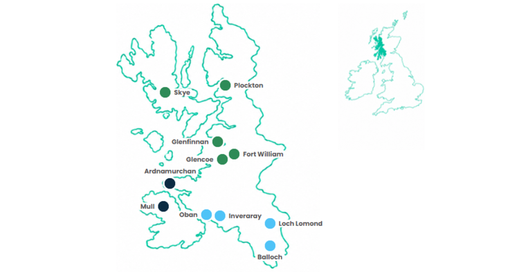
Looking for a West Coast Scotland road trip map? Our route map shows how a journey through western Scotland fits together, from Loch Lomond and Argyll to Mull, Ardnamurchan, Glencoe, Fort William, the Isle of Skye and Plockton.
Scotland’s west coast is shaped by sea lochs, islands, mountain barriers, peninsulas and ferry crossings, so the route is rarely as simple as following one coastal road. The map helps you see the geography before you start planning the detail.
The full Uncover Britain guide brings the route to life with destination information, attractions, scenic stops, ferry-aware planning, overnight ideas and optional detours along the journey.
The route explained
Where Does a West Coast Scotland Road Trip Go?
Our West Coast of Scotland road trip begins around Loch Lomond before travelling west through Argyll towards Inveraray and Oban. From here, ferries and coastal roads open up the island and peninsula landscapes of Mull and Ardnamurchan.
The route then moves into the West Highlands around Glencoe and Fort William before continuing north towards Glenfinnan, the Isle of Skye and Plockton.
This is a road trip shaped as much by water as by roads. Sea lochs create long diversions, ferries connect islands and peninsulas, and mountain ranges determine how one part of the west coast connects with another.
A West Coast Scotland route map therefore makes it much easier to understand how Argyll, Mull, Ardnamurchan, the West Highlands and Skye fit into one journey.
Inside the journey
See How the West Coast Scotland Route Fits Together
The journey is divided into three connected sections, moving from the sea lochs of Argyll through the islands and remote Atlantic peninsulas before reaching the mountains of the West Highlands and the Isle of Skye.
What the full guide adds
The full guide brings the route to life with:
- Destination information
- Attractions & experiences
- Scenic stops & viewpoints
- Ferry-aware route planning
- Places worth exploring
- Overnight ideas
- Optional detours
- Flexible itinerary planning
Inside the full guide
See the Route, Then Explore What’s Along It
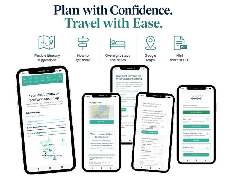
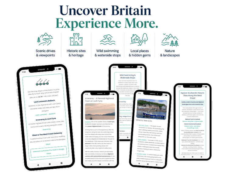
The full digital guide goes beyond the West Coast Scotland map, helping you follow each section and discover the destinations, attractions, scenic roads, islands and experiences along the journey.
Want to see more before you buy?
Visit the full road trip page to see how the West Coast of Scotland route is structured, what you can experience along the way and the highlights included in the guide.
Three connected stages
Explore the Main Sections of the West Coast Scotland Route
Each stage has its own geography, atmosphere and way of travelling.
Argyll & the Sea Lochs
A gentle road into the western Highlands through Loch Lomond, sea lochs, forests, castles and historic towns, gradually opening out towards Inveraray and Oban.
Mull & Ardnamurchan
Ferry crossings, island landscapes, remote roads, wide skies, wildlife-rich coast and the wild Atlantic-facing scenery of Mull and Ardnamurchan.
Skye & the West Highlands
The journey moves into its biggest landscapes, with Glencoe, Ben Nevis, Glenfinnan, the Isle of Skye and the dramatic Atlantic Highlands around Plockton.
Beyond the map
The Map Tells You Where. The Guide Helps You Decide What Is Worth Your Time.
A West Coast Scotland road trip is not simply about joining Loch Lomond, Oban, Mull, Glencoe and Skye on a map.
The experience comes from deciding which islands and peninsulas fit your trip, where worthwhile attractions and viewpoints are found, when a ferry crossing makes sense and which coastal roads deserve more time.
The guide helps you turn the geography into a practical journey, with destination information, scenic context, route structure, ferry-aware planning and ideas that can be adapted to your own pace.
Use the map to understand western Scotland. Use the guide to decide how you want to experience it.
Inside the full guide
Discover the places behind the route
- Written route chapters
- Destination information
- Planning maps
- Attractions and experiences
- Scenic road moments
- Island and ferry planning
- Itinerary ideas
- Overnight and base ideas
- Optional attractions
- Places worth exploring
- Flexible trip planning
- Mobile-friendly access
Distance
How Long Is Our West Coast Scotland Road Trip?
The complete Uncover Britain West Coast of Scotland road trip covers approximately 480 miles, or around 770 kilometres.
The mileage only tells part of the story. Roads on Scotland’s west coast frequently follow sea lochs and mountain contours, while ferries and single-track sections mean relatively short distances can take longer than they appear on a map.
Allowing more time means you can stop for scenery, take ferry crossings without rushing, spend time on Mull or Skye and explore places such as Ardnamurchan, Glencoe and Plockton rather than simply driving through them.
Choose your pace
How Many Days Do You Need for a West Coast Scotland Road Trip?
The route can be adapted from a shorter highlights trip to a slower two-week Highlands and islands holiday.
3–5 days
Focus on selected highlights around Argyll, Glencoe, Fort William and Skye rather than trying to include every island and peninsula.
5–7 days
Follow the core west coast route with more realistic driving days, scenic stops and time for ferry planning.
7–10 days
Add Mull, Ardnamurchan and deeper Skye exploration, with more time for walking, beaches, harbours and wildlife.
10–14+ days
Travel slowly, linger on islands and peninsulas and build weather flexibility into a more immersive west coast journey.
Route geography
Places on Our West Coast Scotland Road Trip Map
These destinations and regions show how the route moves from the southern Highlands towards the islands and dramatic landscapes of northwest Scotland.
Before you go
Planning a West Coast Scotland Road Trip
The geography of western Scotland means a little planning makes a big difference to how relaxed the journey feels.
When shaping your route, think about:
- how many days you have
- which islands and peninsulas you want to include
- ferry crossings and timings
- how much time you want on Mull or Skye
- where you want to stay overnight
- walking, wildlife, castles, beaches or scenic drives
- weather flexibility
- whether this forms part of a longer Scotland road trip
More Scotland inspiration
Continue Planning Your Scotland Road Trip
Explore more free inspiration and related routes while you decide how the west coast fits into your wider Scotland journey.
Quick answers
West Coast Scotland Road Trip Map FAQs
Can I see a West Coast Scotland road trip route on a map?
Yes. The West Coast Scotland road trip map on this page shows the broad geography of our route from Loch Lomond and Argyll through Mull and Ardnamurchan to Glencoe, Fort William, Skye and Plockton.
Where does the West Coast Scotland road trip start?
Our route begins around Loch Lomond before moving west through Argyll towards Inveraray and Oban, then continuing through the islands, peninsulas and West Highlands.
Does the route include Mull and Skye?
Yes. The complete guide includes both the Isle of Mull and the Isle of Skye as part of the wider West Coast of Scotland journey, although the route can be adapted if you have less time.
Does the West Coast Scotland route involve ferries?
Yes. Ferries form part of the geography of this journey, particularly around the island and peninsula sections. The full guide helps explain how those crossings fit into the route.
How long is the West Coast Scotland road trip?
The complete Uncover Britain route covers approximately 480 miles, although your actual mileage will vary depending on detours, accommodation and the islands or additional stops you include.
How many days do you need for the West Coast of Scotland?
A shorter highlights journey can be done in around 3–5 days, but 7–10 days gives a better pace for Argyll, Mull or Ardnamurchan, Glencoe, Fort William and Skye. A slower 10–14+ day trip allows more time for islands, walking, wildlife and weather flexibility.
What does the full guide add to the West Coast Scotland map?
The map shows how the journey fits together geographically. The full guide adds destination information, attractions, scenic stops, ferry-aware route planning, overnight ideas, optional detours and practical information to help you decide what to include.
Turn the West Coast Scotland Map Into Your Road Trip
See how the journey fits together, then use the full West Coast of Scotland Road Trip Guide to discover the destinations, islands, attractions, scenic stops and route ideas that can make the trip your own.