

143 miles (230km) with approx. drive time 4 hours and 30 min
Customisable and Live Navigation via Google Maps – bit.ly/skye-custom-coast
Part 1: Trotternish & the Cuillin Loop — Skye’s Great Landscapes
This first part of the journey is Skye at its most dramatic and unforgettable.
Starting from the Skye Bridge at Kyleakin, the route loops through the island’s most powerful scenery: the harbour town of Portree, the towering cliffs and landslip landscapes of the Trotternish Peninsula, and the dark, jagged mountain wall of the Cuillin.
Here you’ll walk beneath the Old Man of Storr, drive the extraordinary Quiraing, follow empty coastal roads around the north of the island, and cross into the heart of Skye’s mountain country at Sligachan and Glen Brittle.
This is not a fast route. Distances are modest, but the scale of the landscape, the number of short walks, and the constant pull of viewpoints mean this section rewards time and patience.
It is the geological and visual heart of Skye — the part of the island that gives it its worldwide reputation.
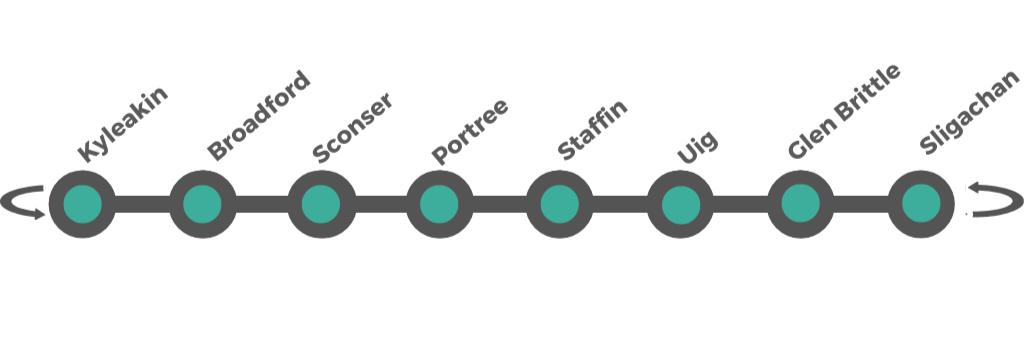
Part 1: Trotternish & the Cuillin Loop Kyleakin > Broadford > Sconser > Portree > Staffin > Uig > Glenbrittle > Sligachan > Broadford
143 miles (230km) with approx. drive time 4 hours and 30 min
The island’s most dramatic and iconic scenery: cliffs, pinnacles, landslips and mountain walls.
The route is broken down into smaller segments:
Arrival on Skye — Kyleakin > Broadford > Sconser > Portree
Central Trotternish — Trotternish Ridge > Old Man of Storr > Kilt Rock & Lealt Falls
West Coast of Skye — Dunvegan Castle > Neist Point > MacLeod’s Tables & Talisker Distillery
The Cuillin & Glen Brittle — Glen Brittle > Fairy Pools > Sligachan
How to Spend Your Time
The Isle of Skye is one of Scotland’s most stunning destinations, known for its dramatic landscapes, rugged coastline, and rich history. This itinerary focuses on the key locations on the island for this coastal section, ensuring a mix of scenic drives, hikes, castles, and iconic viewpoints. Additional days cover hiking the Old Man of Storr, exploring the Quiraing, visiting Dunvegan Castle, Neist Point, Fairy Pools, and other highlights.
-
4-Day Isle of Skye Itinerary (Best of Skye in a Short Trip)
Ideal for: Travelers who want to see the major highlights without long hikes.
Day 1: Arrival & Southern Skye (Kyleakin, Broadford, Sconser, Sligachan)
Arrive via Skye Bridge, stopping in Kyleakin for views of Castle Moil.
Visit Broadford, a great place to stop for lunch and admire views over Beinn na Caillich.
Drive to Sconser, the departure point for ferries to Raasay (optional detour).
Continue to Sligachan and stop at Sligachan Waterfalls, with views of the Cuillin Mountains.
Stay overnight in Portree, the island’s main town, where you can explore its colorful harbor.
Day 2: Northern Skye (Old Man of Storr, Quiraing, Staffin, Uig, Fairy Glen)
Start the day with a hike around the Old Man of Storr, one of Skye’s most iconic rock formations.
Continue to the Quiraing, a landslip with surreal, otherworldly landscapes.
Visit Staffin Beach, where you can see dinosaur footprints at low tide.
Drive to Uig, the ferry port for the Outer Hebrides, and explore the Fairy Glen, a mysterious landscape of small, rounded hills.
Return to Portree for the night.
Day 3: Western Skye (Dunvegan Castle, Neist Point, Coral Beach)
Visit Dunvegan Castle & Gardens, home of Clan MacLeod.
Take a short walk to Coral Beach, known for its white shell sand and clear waters.
Drive to Neist Point, one of the most famous viewpoints in Skye, with a dramatic lighthouse and sea cliffs.
Stay overnight in Dunvegan or Portree.
Day 4: Southern Skye (Glenbrittle & Fairy Pools)
Drive to Glenbrittle and hike to the Fairy Pools, beautiful blue and green waterfalls at the base of the Cuillins.
Stop for a final meal in Broadford or Sligachan before heading back.
-
5-Day Isle of Skye Itinerary (Adding More Scenic Walks)
Follow the 4-day itinerary, then add:
Day 5: Raasay or Extended Exploration
Take the ferry from Sconser to Raasay, a peaceful island with fantastic viewpoints over Skye.
Walk up to Dùn Caan, Raasay’s highest point.
Alternatively, stay on Skye and explore more of Trotternish Peninsula, including the Brother’s Point coastal walk.
-
7-Day Isle of Skye Itinerary (Fully Exploring the Region)
Ideal for: Travelers who want to experience everything Skye has to offer, with time for additional hikes and cultural sites.
Follow the 5-day itinerary, then add:
Day 6: Extended Trotternish Exploration (Rubha Hunish & Kilt Rock)
Walk to Rubha Hunish, the northernmost point of Skye, for stunning coastal views.
Visit Kilt Rock and Mealt Falls, a dramatic sea cliff waterfall.
Explore hidden gems such as the Lealt Falls Viewpoint.
Day 7: Cuillin Mountains or Boat Trips
For adventurous travelers, consider a guided hike into the Cuillin Mountains.
Alternatively, take a boat trip from Elgol to Loch Coruisk, a remote glacial loch surrounded by dramatic peaks.
-
Hiking the Old Man of Storr
Duration: 2–3 hours round trip
One of Skye’s most iconic landscapes, featuring towering rock pinnacles.
Exploring the Quiraing
Duration: 2–3 hours round trip
A surreal landslip with dramatic cliffs, plateaus, and rock formations.
Visiting the Fairy Glen
A unique landscape of grassy mounds and stone formations, often linked to Skye’s folklore.
Dunvegan Castle & Gardens
The ancestral home of Clan MacLeod, offering historic interiors and beautiful gardens.
Neist Point
A lighthouse at the end of dramatic sea cliffs, perfect for photography at sunset.
Fairy Pools
A series of crystal-clear waterfalls and pools at the base of the Cuillin Mountains.
Sligachan Waterfalls
Situated near the Sligachan Hotel, with fantastic views of the Cuillins.
Arriving on Skye
Most journeys to Skye arrive from the mainland via Kyle of Lochalsh, either as part of a wider west coast route or after travelling through the Highlands from Inverness, Fort William or Glencoe.
For many travellers, this crossing marks a real psychological shift. The mountains fall away behind you, the sea opens out ahead, and Skye begins to assert its own character — wilder, more elemental, and more exposed to the Atlantic.
The Skye Bridge carries you across Loch Alsh to Kyleakin, and from here the road immediately begins to trace the island’s coastline and bays. It’s worth slowing down almost straight away — the first few miles already offer a sense of Skye’s scale, light and openness.
Before crossing, there’s an excellent Kyle of Lochalsh viewpoint on the mainland side, which makes a fitting pause to take in your first wide views of the island.
Once on Skye, the route heads north-east towards Broadford, easing you gently into the landscape before the bigger scenery of the Trotternish and Cuillin begins.
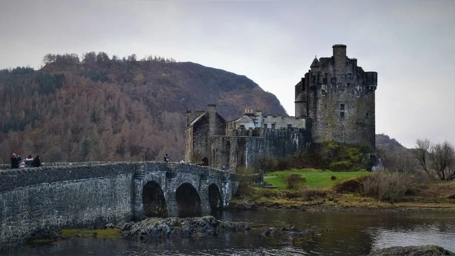
Arrival on Skye: Kyleakin
Cross the Skye Bridge at Kyleakin — the main road entrance to the island and the symbolic start of your Skye journey.
Kyle of Lochalsh Viewpoint (before crossing, optional) — A great first overview of Skye, with wide views across Loch Alsh to the Cuillin and the island’s mountainous interior.
Kyleakin — Gateway to Skye
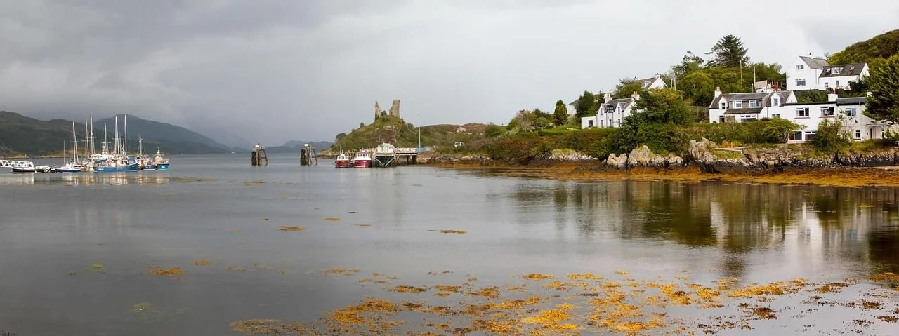
The symbolic arrival point on Skye via the Skye Bridge
Castle Moil ruins with panoramic views over Loch Alsh
Peaceful harbour and waterfront walks
Boat trips into the Inner Sound and Loch Alsh
A calm, human-scale first stop before the bigger landscapes ahead
What to See & Do
Castle Moil (Caisteal Maol) – The atmospheric ruins of a 15th-century castle standing on a rocky promontory above the village, with superb views over Kyleakin, the Skye Bridge, and the surrounding sea lochs. It’s a short, steep walk up, but well worth it for the viewpoint alone.
Kyleakin Waterfront & Harbour Walk – A pleasant stroll along the shoreline with views across to Kyle of Lochalsh, fishing boats in the harbour, and the bridge stretching across Loch Alsh. A good place to stretch your legs after the crossing or take a boat tour from Kyleakin.
Boat Trips on Loch Alsh & the Inner Sound – Local operators offer boat trips exploring the surrounding waters, often spotting seals, seabirds, and occasionally dolphins, while also sharing stories of the area’s maritime and clan history.
Local Cafés & Pubs – A good first stop for food, coffee or a relaxed meal before heading further into the island.
Kyleakin is the first village most travellers reach on the Isle of Skye, sitting right at the eastern edge of the island beside the Skye Bridge and facing the mainland village of Kyle of Lochalsh across Loch Alsh.
It’s a small place, but an important one — not just geographically, but emotionally. This is where Skye begins to feel like an island, where the mainland falls away behind you and the landscape starts to open out into sea, mountains and wider horizons.
Kyleakin makes a gentle, unhurried introduction to Skye, with coastal walks, historic ruins, and wide views across the water before the road leads you deeper into the island.
-
Kyleakin is compact and easy to explore on foot, and a short walk here makes a great way to stretch your legs after crossing the Skye Bridge.
Start at the harbour area, where you can follow the shoreline path with views back across Loch Alsh to Kyle of Lochalsh and the bridge itself. From here, continue along the waterfront promenade, watching fishing boats and seabirds in the sheltered bay.
The walk’s main highlight is the path up to Castle Moil (Caisteal Maol). The route climbs fairly steeply from the village, but it’s short, and the reward is one of the best viewpoints in this part of Skye. From the ruins, you get wide views over the bridge, the village, and the surrounding sea lochs.
After visiting the castle, you can either return the same way or make a small loop through the upper part of the village before descending back towards the harbour. The whole walk takes around 60–90 minutes at an easy pace, including time at the viewpoints.
-
Parking:
There are several small public parking areas around the harbour and village centre in Kyleakin, suitable for cars and small vans. The most convenient places to look are:Harbour / waterfront parking area near the main village centre
Roadside parking bays along the seafront and near the start of the Castle Moil path
Spaces are limited in high season, so it’s best to arrive earlier in the day if visiting in summer.
Facilities:
Kyleakin has cafés, pubs, accommodation, and small shops. It’s a good place for a first food stop or coffee after arriving on Skye.Time Needed:
Allow 1–2 hours for a relaxed visit, or longer if you’re taking a boat trip or stopping for a meal.Boat Trips:
Seasonal boat trips operate from Kyleakin into Loch Alsh and the Inner Sound. These usually need to be booked in advance in busier months.Driving On:
Kyleakin is right at the island entrance, so it works best as a short, atmospheric first stop before continuing towards Broadford, Portree and the north of the island.
On the Road: Kyleakin → Broadford
Leaving Kyleakin, the road begins to follow the coast and low hills towards Broadford. This is a beautiful, easy-paced stretch of driving that gently opens out Skye’s landscape before the road climbs further north.
Scenic Stops Along the Way
Ashaig Beach – A quiet, often overlooked pebble beach with open views across the water, ideal for a short pause and a first taste of Skye’s shoreline.
Loch Ainort viewpoint – A roadside viewpoint overlooking the long, narrow sea loch that cuts deep into the island, with changing light and reflections that often make this a surprisingly photogenic stop.
Eas a’ Bhradain (Salmon Waterfall) – A small but attractive waterfall beside the road near Luib. The name means “Salmon Waterfall” in Gaelic, a reminder of how important fishing has been in Highland life for centuries.
Highland Cows Viewpoint (seasonal and occasional) – You may be lucky enough to spot Highland cattle grazing near the road here — one of those classic Skye photo opportunities when they’re present.
Continuing to Broadford
From here, the road continues on to Broadford, Skye’s second-largest settlement and a practical hub with fuel, shops, food and accommodation. Even if you don’t stop on this first pass, you’ll naturally return here later in the journey as the route loops back from the west.
Broadford also makes a sensible place to:
Re-stock supplies
Stay overnight
Or simply pause before continuing north towards Portree and the Trotternish Peninsula
Broadford — The Island’s Main Hub & Natural Base
Broadford sits on the A87, the main road that runs the length of Skye from the Skye Bridge to Portree and the north of the island. Set around a wide, open bay on the island’s south-east coast, it is Skye’s second-largest settlement and one of its most useful.
While it doesn’t have the dramatic scenery of the north or the Cuillin, Broadford plays an important role in any Skye journey. It’s a natural resupply point and overnight base, with fuel, shops, cafés, accommodation and services — and a good place to pause before heading deeper into the island or turning south towards the Sleat Peninsula.
Historically, Broadford was an important local centre for trade, fishing and farming, and today it remains a practical hub for exploring both the Cuillin mountains and the wider island.
The setting is calmer and more open than much of Skye, with long views across Broadford Bay towards the mainland and the islands offshore — a gentler landscape that provides a good contrast to what lies ahead.
One of the best places on Skye for supplies, fuel and services
A sensible first or last overnight stop on the island
Easy access to the Cuillin, Sleat Peninsula and the main northbound route
Wide bay views and a more settled, spacious feel
Several easy walks and viewpoints nearby
What to See & Do
Broadford Bay — A broad, open bay with long coastal views and a peaceful atmosphere. Good for gentle shoreline walks, watching light and weather move across the water, and, in calm conditions, kayaking or paddleboarding.
Pabay Viewpoint — A quiet roadside viewpoint looking out to the small island of Pabay and across Broadford Bay. Especially good in early morning or evening light.
Breakish Coastal Walk — An easy, flat shoreline walk just outside Broadford, ideal for stretching your legs after driving and enjoying open coastal scenery without committing to a long hike.
Skye Serpentarium — A small but interesting attraction showcasing reptiles, amphibians and invertebrates, with informative displays and talks.
Broadford Community Woodland — A peaceful local nature reserve with gentle walking trails just outside the town.
Nearby detours — From Broadford you can also reach places like Kilchrist Church and the Torrin Pools with a short drive.
Broadford is not about big sights — it’s about making the rest of Skye work smoothly. It’s a place to pause, prepare, and reset before the island becomes wilder, quieter and more dramatic.
-
Parking:
Broadford has several public parking areas and on-street spaces around:The main village centre and shops
Near the waterfront / bay area
Around the Co-op, fuel station and local services
Parking is generally easier here than in Portree or the northern parts of Skye, even in busy seasons.
Facilities:
Broadford is one of the best places on Skye for fuel, food shopping, cafés, takeaway food, accommodation and basic supplies.Time Needed:
Allow 1–2 hours for a short stop, or use it as an overnight base before heading north or south.Good to Know:
This is the last major resupply point before heading into more remote parts of the island, especially if you’re going towards the Cuillin, Trotternish or Sleat. -
Broadford isn’t a walking destination in itself, but it’s surrounded by easy, low-level walks that are perfect for arrival or departure days.
The Breakish Coastal Walk offers a flat, scenic stroll along the shoreline with open views across the bay and towards the mainland. It’s ideal if you want something gentle after a long drive.
The Broadford Community Woodland provides short, peaceful woodland circuits on the edge of town, good for a quiet break or a leg stretch.
Along the bay itself, informal shoreline walking is possible at various points, with wide views and changing light making this a surprisingly relaxing place to wander.
Sconser - Gateway to Raasay & The Red Cuillin Coast
Sconser is a small, scattered settlement stretched along the eastern shore of Skye, sitting between Broadford and Portree with wide views across the Sound of Raasay. It’s not a town in the conventional sense, but it plays an important role in the journey: this is where Skye starts to feel more open, more mountainous, and more distinctly “island”.
The coast here is dominated by views of the Red Cuillin and the long, low outline of Raasay across the water. The road hugs the shoreline, with frequent glimpses of sea, skerries and distant hills, and it feels very different from the gentler landscapes around Broadford.
Sconser is best known as the ferry crossing point to the Isle of Raasay, making it an optional but very rewarding side trip if you have the time. Even if you’re not crossing, this stretch of coast is a beautiful, unhurried drive and a good place to stop, breathe, and take in your first big mountain views on Skye.
Ferry crossing point to the Isle of Raasay (and Raasay Distillery)
Excellent views across the Sound of Raasay to the Red Cuillin
Coastal walks and quiet shoreline scenery
Skye’s only golf course, with dramatic mountain and sea views
A calm, scenic pause between Broadford and Portree
What to See & Do
Raasay Ferry & Raasay Distillery – The small ferry from Sconser takes you across to the Isle of Raasay. Once there, the Raasay Distillery offers guided tours and tastings of its island whisky, as well as beautiful views back towards Skye.
Coastal Walks – The shoreline around Sconser offers gentle, open walks with constant views across the water to Raasay and the Red Cuillin. These are ideal for short, informal strolls rather than big hikes.
Isle of Skye Golf Course – A beautifully located 9-hole course with wide views over sea and mountains. Even non-golfers often stop here just for the scenery.
Red Cuillin Views – This stretch of coast gives some of the best roadside views of the Red Cuillin mountains, especially in changing light.
From Broadford, the road north towards Portree becomes more dramatic and more mountainous. Sconser is a natural halfway point on this leg of the journey — either as a short stop, or as a longer pause if you’re taking the ferry to Raasay.
As a side note: you’ll encounter Sligachan later in the journey, when the route loops back down the west side of the island towards Broadford via Glen Brittle — not on this east coast stretch.
-
Parking:
Small informal lay-bys along the coast
Parking near the Raasay ferry terminal
Parking at the Skye Golf Course
Ferry to Raasay:
Short crossing (around 25 minutes)
Check CalMac timetables in advance, especially in summer
Time Needed:
20–40 minutes for a short scenic stop
Half a day if including a trip to Raasay
Facilities:
Limited locally — better services in Broadford or Portree
-
The ferry from Sconser to the Isle of Raasay offers an easy and rewarding island side-trip, taking you across the Sound of Raasay to one of the Inner Hebrides’ quietest and most characterful islands.
Crossing time:
The ferry takes around 25 minutes each way.How long to allow:
Half day minimum – enough for a visit to Raasay Distillery and a short walk or lunch stop.
Full day – if you want to explore more of the island, enjoy coastal walks, or travel at a relaxed pace.
What you’ll find on Raasay:
Raasay Distillery with tours, tastings and a café
Quiet roads, coastal walks and big views back to Skye
A much calmer, less-visited island atmosphere than Skye itself
Booking & planning:
The ferry is operated by CalMac and should be booked in advance in peak season.
Check sailing times carefully, as services are less frequent than main island routes.
If taking a car, availability can be limited in summer.
Who it’s best for:
Those with extra time in their schedule
Whisky fans, slow travellers, and anyone wanting a quieter island experience
Less suitable if you’re trying to complete the Skye loop in a tight timeframe
This is a beautiful but optional detour — easy to add if you have the time, and easy to skip if you’re focusing on the main Skye route.
On the Road: Sconser → Portree
Leaving Sconser, the road continues north along Skye’s eastern side, with increasingly dramatic mountain views and a growing sense that you’re entering the island’s core landscapes.
Note on Sligachan: Although Sligachan lies on the road between Sconser and Portree, we visit it later in the loop when approaching from Glen Brittle and the west. This allows you to experience it as part of the Cuillin mountain section of the journey, when its landscape and setting make more sense in the story of the route. You’ll pass through it now — but the proper stop comes later.
Scenic Stop Along the Way
Isle of Skye Candle Co. Visitor Centre — Just before reaching Portree, this small visitor centre offers a short, interesting stop where you can watch candles being made and browse locally produced goods.
Las (formerly the Aros Centre) - A high roadside viewpoint just above Portree offering one of the best panoramic views over the town, the harbour, and the surrounding cliffs of the Trotternish coastline. It’s an easy stop with minimal walking and gives a brilliant sense of Skye’s scale, sea cliffs and layout before you descend into Portree itself. It works perfectly as a first Skye “wow” moment and a photo stop.
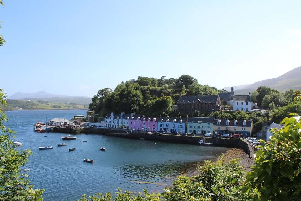
Portree — Skye’s Capital & Natural Base
What to See & Do
Portree Harbour — The heart of the town, lined with colourful buildings and backed by cliffs. It’s a great place for an evening walk, watching boats come and go, and enjoying the changing light.
Town Walks & Viewpoints — Short walks around the edge of town and above the harbour offer lovely views back across the bay and out towards the hills.
Shops, Galleries & Local Crafts — Portree is the best place on Skye for browsing local art, crafts, gifts and outdoor gear.
William Somerset Maugham Statue — A small literary footnote near the harbour, marking the writer’s connection to Skye.
Kiltaraglen Track — A nearby walking and cycling route that provides an easy, scenic way to stretch your legs without committing to a mountain hike.
Scorrybreac Trail (see accordion below) – A superb circular coastal walk from Portree climbing above the town to cliffs and headlands, with big views back over the harbour and across to the Cuillin on clear days.
Loch Leathan & Loch Leathan Dam Viewpoint (see accordion below) – A short drive or walk south of Portree to a quiet loch and dam with open views towards the Red Cuillin and a peaceful, less-visited walking area.
Portree is where Skye shifts from transit to exploration. From here, the route branches out into the heart of the Trotternish Peninsula — to the Old Man of Storr, the Quiraing, and Skye’s most famous landscapes.
Most travellers will spend at least two nights here before continuing the loop
Portree is the largest town on Skye and the island’s main centre for accommodation, food, shops and services. Set around a sheltered harbour and backed by rising hills, it feels both busy and beautifully placed.
For most travellers, Portree becomes the main base for exploring the Trotternish Peninsula and northern Skye — and it’s easy to see why. It combines practicality with scenery in a way few other places on the island do.
Skye’s main service centre and accommodation hub
A natural base for exploring Trotternish, Storr and the Quiraing
One of the island’s most photogenic harbours
Excellent choice of restaurants, cafés, shops and galleries
-
Loch Leathan lies just 3 miles (5 minutes’ drive) south of Portree and makes a quiet, scenic stop away from the busier parts of Skye. It sits in open moorland with wide views towards the Red Cuillin, giving you a real sense of Skye’s big, open landscapes without needing a long hike.
The Loch Leathan Dam is part of a small hydroelectric scheme and is easy to reach by car. There is informal roadside parking near the dam, from where you can walk along the loch shore or across the dam itself for different viewpoints.
It’s ideal for:
A short, peaceful walk
A quick photo stop in changing light
A quiet break from Portree before or after exploring the Trotternish area
Time needed: 20–60 minutes
Best for: Easy walking, views, photography, and a calm pause in the journeyIt works especially well combined with Portree or as a gentle stop on your way south or west across the island.
-
If you’re staying in Portree, the Scorrybreac walk is one of the most rewarding short walks you can take straight from the town centre. This circular trail offers stunning views over Portree Bay, the Isle of Raasay, and the dramatic landscapes of northern Skye – all without the need for a car.
Distance: Approx. 2.5 km (1.5 miles). Duration: 1 to 1.5 hours at a gentle pace. Difficulty: Easy to moderate. Start/End Point: Portree harbour (near the Cuillin Hills Hotel entrance)
The trail begins just east of Portree Harbour and climbs gently along a well-maintained path through heathland and coastal moor. You’ll pass through Scorrybreac, the ancestral lands of Clan Nicolson, where a cairn and information board mark the clan’s heritage.
As you walk, the route hugs the coast with spectacular sea views across to Raasay and sometimes as far as the Applecross peninsula on the mainland. You might spot seabirds and, with luck, even seals basking on the rocks below.
About halfway along, the trail turns inland through native woodland and open grassland before looping back to town. There are several benches along the route, ideal for soaking in the peaceful setting.
Highlights
Gorgeous sunset or early morning light over the bay
Views of The Lump, a small peninsula with the Apothecary’s Tower
Local flora and birdlife along the coastal edge
Clan Nicolson memorial cairn
Perfect as a pre-dinner stroll or a gentle outing on a rest day
Central Trotternish — Storr, Lealt & Kilt Rock
This is where Skye begins to show its most instantly recognisable shapes.
Leaving Portree, the road runs north beneath the long wall of the Trotternish Ridge, where huge landslips have torn the landscape into cliffs, pinnacles and broken terraces. This short stretch of coast packs some of the island’s most famous sights into just a few miles, but it never feels crowded once you step away from the car.
Here you’ll walk beneath the towering rock needle of the Old Man of Storr, look down into the deep sea-cut gorge at Lealt Falls, and stand on the edge of Kilt Rock where a waterfall drops straight from cliff-top into the Sound of Raasay. Across the water, the mountains of the mainland rise like a distant wall, giving constant scale and drama to the views.
It’s an easy half-day of short walks and big scenery — a perfect introduction to the geological drama that defines the whole of the Trotternish Peninsula.
-
The Trotternish Loop is the name commonly given to the circular drive around the northern peninsula of Skye, usually described as:
Portree → Storr → Staffin → Quiraing → Uig → back to Portree
It is a spectacular half-day or full-day circuit focused entirely on the Trotternish Peninsula and its unique landslip landscape.
This road trip uses part of that famous loop — but goes much further.
Instead of returning to Portree after Uig, this route continues:
Along Skye’s wild west coast
To Dunvegan and Neist Point
Past Talisker and Glen Brittle
Beneath the Cuillin mountains
And back via Sligachan
In other words, this guide includes the best of the Trotternish Loop as the northern section of a much larger and more varied circuit: The Trotternish & Cuillin Loop.
If you only have half a day, the classic Trotternish Loop works well. If you want to experience Skye as part of a wider west coast journey, this longer route shows how all of Skye’s great landscapes connect together.
-
The Trotternish Ridge is the long, broken spine of cliffs and escarpments that runs down the eastern side of the Trotternish Peninsula.
It was formed by one of the largest landslip systems in Europe, where huge sections of the plateau have slowly collapsed towards the sea over thousands of years. This is what creates Skye’s most dramatic shapes: pinnacles, terraces, hidden basins, vertical cliffs and strange, tilted landscapes.
Famous landmarks like the Old Man of Storr, The Quiraing, Lealt Falls and Kilt Rock all sit along this unstable geological edge.
What makes the ridge so special is not just its scale, but its constant sense of movement and change — cliffs fracture, slopes creep, and the whole landscape feels alive and unsettled in a way that is unique in Britain.
It is this geology that gives the Trotternish Peninsula its unmistakable, almost otherworldly character.
Trotternish Ridge
The Trotternish Peninsula is a rugged and scenic area located on the northern end of the Isle of Skye in Scotland. It is characterised by its distinctive landscape, featuring dramatic cliffs, rocky coastlines, and unique geological formations. One of the most notable features of the Trotternish Peninsula is the Trotternish Ridge, a series of steep cliffs and escarpments running along the peninsula's eastern side. The ridge is home to several iconic geological formations, including the Old Man of Storr and the Kilt Rock.
Old Man of Storr
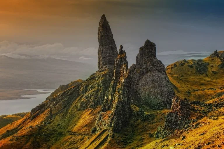
The Old Man of Storr is the most famous rock formation on Skye and one of the most recognisable landscapes in Scotland. This huge stone pinnacle stands isolated beneath the cliffs of the Trotternish Ridge, rising dramatically above the Sound of Raasay and the mainland mountains beyond.
The walk to the viewpoint is one of Skye’s classic short hikes and rewards you with one of the best panoramas on the island. From the upper path, the view stretches across the sea to Applecross and Torridon, with the cliffs and landslip terraces of the ridge towering behind you.
Visiting the Old Man of Storr
Walk length: Around 3.8 km return
Time needed: 1.5–2.5 hours depending on pace and conditions
Difficulty: Moderate, with a steady uphill climb on a well-made path
Parking: Large dedicated car park beside the A855
Good footwear is essential, as the path can be wet and slippery after rain. The weather changes quickly here, and cloud can wrap around the cliffs even on clear days elsewhere on the island.
Early morning and late afternoon are the best times to visit, both for quieter conditions and for the changing light on the cliffs and sea.
The Old Man of Storr is not just a photo stop — it’s one of the finest short walks in Scotland, and a true introduction to Skye’s dramatic geology.
Kilt Rock & Mealt Falls
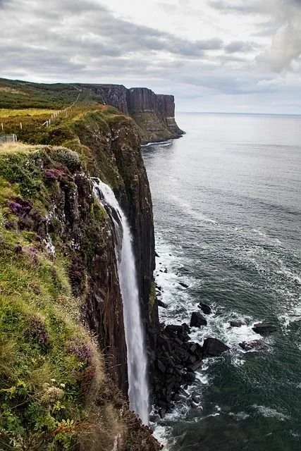
This is the cliff-edge finale of the east coast Trotternish stretch before heading north to Staffin and the Quiraing.
Kilt Rock is one of Skye’s most striking coastal cliffs, named for the vertical columns of basalt that resemble the pleats of a tartan kilt. Beside it, Mealt Falls drops directly from the clifftop into the Sound of Raasay below — one of the few waterfalls in Scotland that falls straight into the sea.
The viewpoint sits high above the water, with huge open views across to the mainland mountains of Torridon and Applecross. On a clear day, the sense of space and exposure is extraordinary, and the sound of the waterfall carries up from the cliff face below.
Visiting Kilt Rock & Mealt Falls
Access: Direct from the A855 with a large, dedicated car park
Walk: Very short, flat walk to the fenced viewpoint
Time needed: 10–20 minutes
Facilities: Toilets usually available at the car park (seasonal)
Safety: Stay behind barriers — the cliffs are extremely exposed
It’s a perfect short stop: high impact, minimal effort, and a natural punctuation point before the route turns north towards the wild landscapes of Staffin and the Quiraing.
Northern Trotternish — Staffin & the Quiraing
Beyond Kilt Rock, the road begins to feel quieter and more open. The traffic thins, the cliffs pull back, and the landscape starts to widen into long views, empty moorland and distant horizons. The drive north becomes less about individual viewpoints and more about space, light and scale.
This is the northern end of the Trotternish Peninsula, where the island feels less visited and more elemental. Here, Skye’s deep past becomes visible — from dinosaur footprints on the shoreline to the vast, slowly collapsing landslip scenery of the Quiraing. Across the water, the mountains of the mainland form a constant backdrop, reinforcing the sense that you are now on the outer edge of the island.
It’s a stretch of coast that invites you to slow down and absorb the landscape before the route climbs into one of the most extraordinary geological formations in Britain.
Staffin & An Corran
Staffin sits on the northeast coast of Skye beneath the towering walls of the Trotternish Ridge and makes a natural base for exploring this wild corner of the island. It’s a place of wide views, open shoreline and huge geological presence rather than a traditional village centre.
Just outside the village lies An Corran Beach, one of Skye’s most remarkable and historically important coastal spots. Backed by dark dolerite cliffs and facing the Quiraing across the water, this long, rocky-sandy shore has been inhabited by humans since around 7,000 BC.
It is also one of the few places in the UK where dinosaur footprints can sometimes be seen on the shoreline at low tide, preserved in the ancient rock. Even when the prints aren’t visible, the sense of deep time here is extraordinary.
What to see & do around Staffin
An Corran Beach — dramatic coastal views, geology, and occasional dinosaur footprints at low tide
Staffin Dinosaur Museum — a small, family-run museum explaining Skye’s Jurassic fossils, dinosaur footprints, and the island’s extraordinary geological history
Staffin cliffs & viewpoints — wide views across the Sound of Raasay and up towards the Quiraing
Skye Museum of Island Life (Kilmuir) — a beautifully preserved crofting township showing how life on Skye looked a century ago
Staffin is less about ticking off sights and more about absorbing scale, light and landscape — a quiet pause before the drama that comes next.
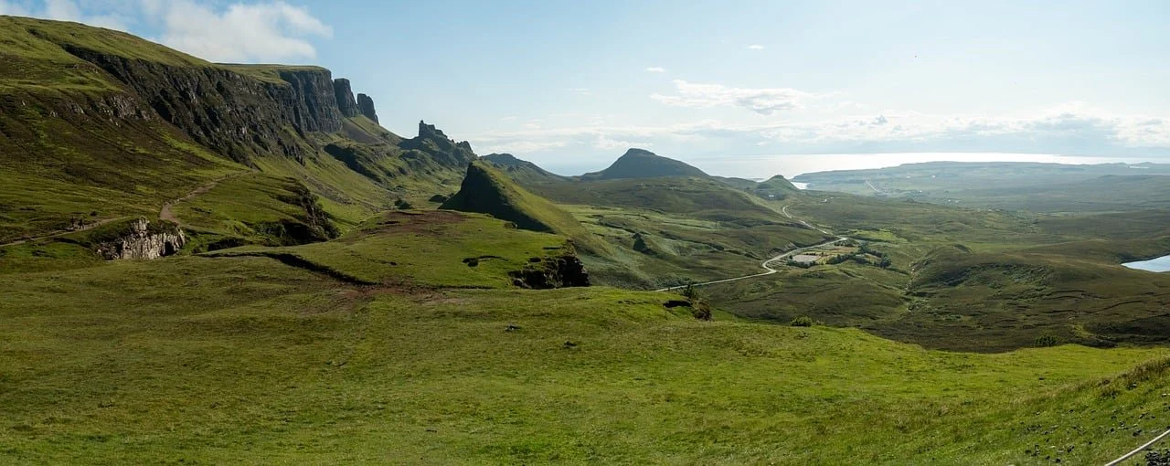
The Quiraing
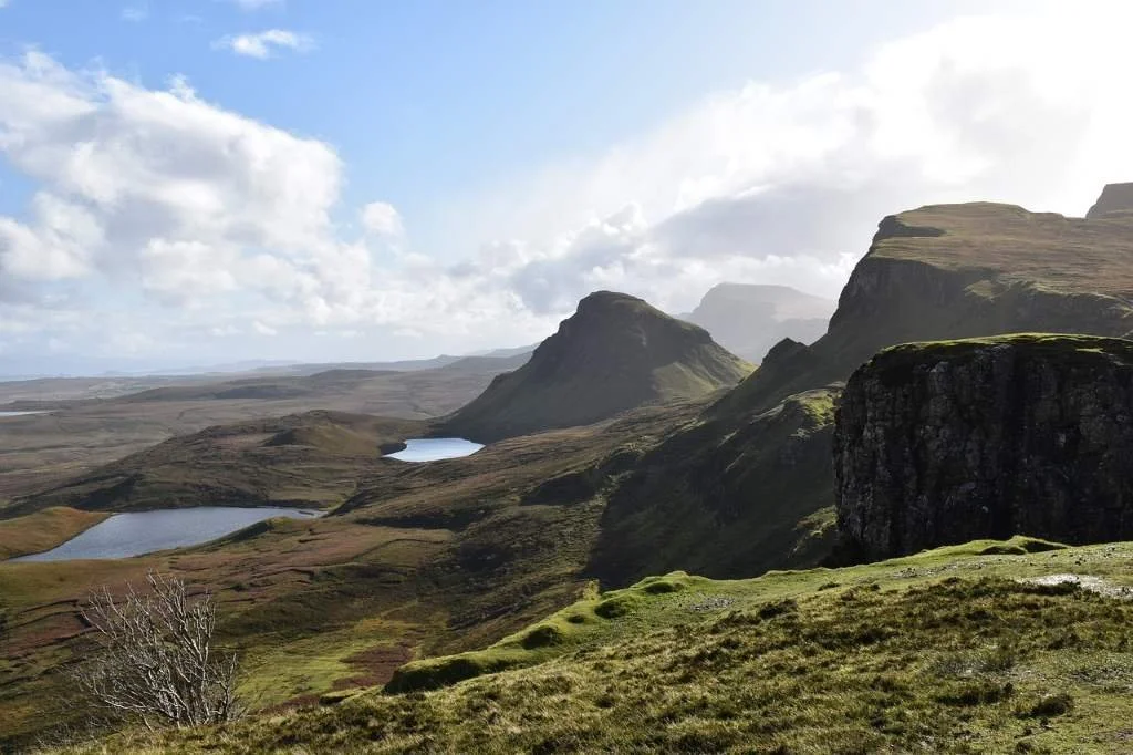
The Quiraing is one of the most extraordinary landscapes in Britain.
Formed by a massive landslip that is still slowly moving today, this high plateau and cliff system has collapsed into a maze of pinnacles, hidden basins, sheer walls and tilted terraces. The result is a landscape that feels more like Iceland or the Faroes than mainland Britain.
From the road alone, the views are astonishing — but the real experience comes from walking into the heart of it.
Walking the Quiraing
Main route: The Quiraing Circuit
Time needed: 2–3 hours (longer if you linger)
Difficulty: Moderate, with some steep and uneven sections
What you’ll see: The Prison, The Needle, The Table, vast cliffs and rolling plateaus
On clear days, the views stretch across the Sound of Raasay to the mainland mountains and out towards the Outer Hebrides. In mist or cloud, the Quiraing becomes something else entirely — moody, enclosed and almost theatrical.
This is not just one of Skye’s highlights — it’s one of the most unforgettable landscapes anywhere in Scotland.
Practical notes for this section
Weather: The Quiraing is very exposed — cloud and wind can arrive quickly
Footwear: Good boots essential, even in dry weather
Parking: Small car parks near the Quiraing road pass; arrive early in busy seasons
Tides: Check tide times if hoping to see dinosaur footprints at An Corran
West Trotternish & Uig — Fairy Glen, Coast & Duntulm
After the vast scale of the Quiraing, the road turns west and the character of the island changes again. The cliffs begin to face the Atlantic, the traffic thins further, and the landscape becomes more open, greener and quieter. This is the outer edge of the Trotternish Peninsula — a place of long views, scattered ruins, hidden beaches and a strong sense of being on the far side of the island.
The route here is less about ticking off famous sights and more about discovery — small detours, quiet viewpoints and short walks that reveal a softer, but no less dramatic, side of Skye.
On the route towards Uig
A short distance west of the Quiraing road, Idrigill Viewpoint makes an excellent first stop. This small, easily missed lay-by gives wide, open views across the Minch and along the broken coastline, and is one of those places that rewards simply pulling over and standing still for a few minutes.
Further on, just south of Uig, lie the ruins of Hugh’s Castle (Caisteal Uisdein), a small coastal stronghold tucked away on a rocky headland. It’s not a major stop, but it adds to the sense of layered history that runs through this part of Skye.
Uig
Uig sits at the head of a wide bay on Skye’s northwest coast and feels both remote and connected at the same time. It is one of the island’s main ferry ports, with sailings to the Outer Hebrides, but it remains a quiet, small settlement surrounded by big landscapes.
The bay itself is a lovely place for a short walk or picnic, with long views across the water and frequent sightings of seabirds and seals. Uig also makes a useful pause point for supplies, food and accommodation before continuing into the quieter western side of the island.
What to see & do around Uig
Uig Bay — wide, open shoreline with long coastal views and good chances of spotting wildlife
The Fairy Glen (see below) — a short inland detour into a strange, otherworldly landscape of grassy cones and twisted rock formations
Rha Waterfalls — a gentle, scenic stop where water cascades through mossy rock steps close to the road
Uig Woodland Walk — a peaceful, waymarked forest walk near the village
Uig Tower (Captain Fraser’s Folly) — a romantic 19th-century ruin with wide views over the surrounding countryside
Loch Fada — a quiet freshwater loch ideal for a short walk or peaceful pause
The Isle Of Skye Brewing Company — a popular local stop for tours and tastings just outside the village
Ferries from Uig (CalMac)
CalMac Ferries operate regular sailings from Uig to the Outer Hebrides, including Tarbert (Harris) and Lochmaddy (North Uist).
The ferry terminal is located right in the village and is clearly signposted.
Advance booking is strongly recommended, especially in peak season and for vehicles.
Even if you’re not crossing, the harbour area is worth a short stop to watch ferries arrive and depart and to get a sense of Skye’s wider island connections.
The Fairy Glen
Just inland from Uig lies one of Skye’s strangest and most playful landscapes. The Fairy Glen is a tumble of grassy mounds, twisted rock formations and miniature-looking hills that feel completely different from the rest of the island.
There’s no formal path — you simply wander — and that’s part of the charm. It’s an easy, short stop that contrasts beautifully with the epic scale of the Quiraing and the cliffs of the coast. Wander the Glen or follow this walk.
On the coastal route north
As you continue north along the coast:
Clachan Erisco Standing Stones (Borve) — an accessible prehistoric stone circle dating back thousands of years
Clach Ard Pictish Symbol Stone (Skeabost Bridge area) — an important carved stone offering a glimpse into early medieval Pictish culture
These quiet archaeological sites are easy to miss but add depth and time-scale to the journey.
Duntulm Castle — The Wild End of Trotternish
Perched on a sheer cliff edge at the far northern tip of the Trotternish Peninsula, Duntulm Castle feels less like a ruin and more like a fragment of Skye’s raw geology given walls.
This was once the stronghold of the MacDonalds of Sleat, one of the most powerful Highland clans, and for centuries it controlled the sea routes between Skye and the Outer Hebrides. Today, what remains is a roofless, broken shell — but its setting is the real spectacle: huge Atlantic skies, crashing seas far below, and a sense of standing at the very edge of the island.
This is one of the most remote-feeling, atmospheric stops on Skye — less about ticking off a castle and more about experiencing space, exposure and silence.
-
Location: Northern tip of the Trotternish Peninsula, north of Uig
Parking: Small informal roadside parking area near the access track
Walk: Around 10–15 minutes each way on a rough grassy path
Terrain: Uneven, often muddy, and exposed to wind — sturdy footwear essential
Access note: The castle itself is fenced for safety due to unstable masonry, but the viewpoints and headland walk are the real reason to come
How Long to Allow
Allow: 30–60 minutes
More if:
You want to walk the headland properly
You’re photographing or just soaking up the atmosphere
Best Time to Visit
Good light or broken cloud makes this place exceptional
On stormy days it is wild and dramatic, but be cautious near cliff edges
Sunset and late afternoon can be spectacular
-
The Castle Ruins
Duntulm was the seat of the MacDonalds of Sleat until the 18th century. The structure was deliberately dismantled after being abandoned, leaving behind dramatic fragments of walls clinging to the cliff top.You can’t enter the ruin itself, but you can walk around the headland and view it from multiple angles — each more dramatic than the last.
The Headland & Cliffs
This is the real highlight. The cliffs drop steeply into the sea, and on a clear day you can see:The Outer Hebrides
The north coast of Skye stretching away behind you
Endless Atlantic horizons
It’s a superb place for:
Photography
Quiet walking
Simply standing still and taking in the scale of the place
Wildlife & Atmosphere
This is a good spot for:Seabirds riding the cliffs
Occasionally seals offshore
Huge skies, fast-moving weather, and dramatic light
-
Duntulm Castle stands on a cliff-top promontory at the northern end of the Trotternish Peninsula and was once the principal stronghold of the MacDonalds of Sleat, one of the most powerful branches of Clan Donald. Its position gave it strategic control over sea routes between Skye and the Outer Hebrides, making it both a defensive fortress and a symbol of clan authority in the north of the island.
The site was probably fortified from an early period, but the stone castle that survives in ruins today dates mainly from the 16th and 17th centuries. For a time, Duntulm served as the main seat of the MacDonalds of Sleat before they moved their centre of power south to Armadale Castle on the Sleat Peninsula.
Duntulm is closely associated with some of the more violent and turbulent episodes of Highland clan history. According to tradition, one of its most notorious residents was Sir James MacDonald, known as “Black James,” whose rule in the late 16th century became synonymous with cruelty and oppression. One well-known local story tells of a woman being imprisoned and left to starve to death within the castle walls, an episode that has become part of Skye’s folklore and illustrates the harsh realities of clan power in this period.
By the early 18th century, Duntulm was no longer considered a suitable or comfortable residence. The MacDonalds abandoned it in favour of Armadale, and the castle was deliberately dismantled, with stone reused elsewhere, to prevent it being occupied by rivals or government forces. This was a common practice in the Highlands following periods of unrest.
Today, the remains of Duntulm Castle are fragmentary, but its dramatic location and historical associations make it one of the most atmospheric sites on Skye. More than a military structure, it represents the rise and decline of clan authority, the brutal realities of Highland power struggles, and the shift from medieval strongholds to more modern forms of residence and governance.
West Coast of Skye — Clans, Cliffs & Atlantic Light
Leaving the Trotternish Peninsula behind, the route turns west into a broader, more open landscape shaped by sea and weather. The scenery becomes greener and more spacious, the horizons widen, and the Atlantic begins to dominate the mood of the journey.
This side of Skye feels calmer and more settled, but no less dramatic. Instead of landslips and sharp ridges, you’ll find long sea views, powerful headlands and some of the island’s deepest historical roots. This is Clan MacLeod country, where castles, table-shaped hills and sea lochs tell stories that stretch back centuries.
The driving here is slower and more relaxed, linking two of Skye’s great highlights: Dunvegan Castle and the wild headland of Neist Point, with a few tempting detours along the way.
From Uig to Dunvegan — Crossing the Heart of Western Skye
Leaving Uig, the road turns south and west, cutting across the interior of Skye rather than following the coast. The landscape changes almost immediately. The steep, broken cliffs of Trotternish give way to wider moorland, open hills and long, empty glens, with fewer houses and a growing sense of space.
This is a quieter crossing of the island, where the road feels less like a destination route and more like a journey through Skye itself. You’ll pass lochs, peatland and wide views back towards the Cuillin on clear days, before gradually descending into the greener, more settled lands of Duirinish.
As you approach Dunvegan, the sea returns to the horizon and the landscape softens again, with fields, stone walls and scattered crofts replacing the raw geology of the north. The road finally curves around Loch Dunvegan, delivering you directly to one of Skye’s great historical anchors: Dunvegan Castle, home of Clan MacLeod for over 800 years.
This crossing marks a clear shift in mood — from Skye’s wild north to its clan heartland and Atlantic-facing west coast.
Dunvegan Castle & Gardens — Clan MacLeod’s Stronghold
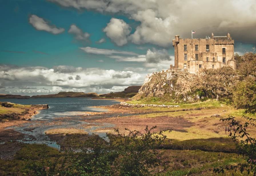
Dunvegan Castle & Gardens is one of the great historical anchors of the Isle of Skye and one of the oldest continuously inhabited castles in Scotland. Set on a rocky outcrop overlooking Loch Dunvegan, it has been the ancestral home of the Chiefs of the MacLeod Clan for over 800 years. Unlike many Highland castles, Dunvegan is not a ruin — it is a living stronghold, gradually expanded and adapted over centuries, and today forms one of Skye’s most rewarding cultural visits.
The setting is as impressive as the building itself, with formal gardens, woodland walks, and long views across the loch adding to the sense of arrival and occasion.
Visiting Tips
Allow 2–3 hours to explore the castle and gardens properly
The site is seasonal (typically open spring to autumn) — check opening dates
Good visitor facilities: café, shop, toilets and parking
Combines very well with a slower west coast day before or after Neist Point
Dunvegan works as the historical heart of the west coast section of Skye — a counterpoint to the raw landscapes that follow.
-
The site has been fortified since at least the 13th century, when the MacLeods established their power base in Duirinish and Waternish. Over the centuries, the castle was expanded from a simple defensive stronghold into a layered complex of towers, halls and residential wings.
Dunvegan has witnessed clan conflicts, royal visits and changing Highland fortunes. It has hosted figures including King James V and Queen Elizabeth II, and remains a rare example of a Highland clan seat that has never fallen out of family ownership.
-
What to See Inside
The interior rooms are rich with clan history and artefacts, including:
The Fairy Flag — the most famous treasure of Clan MacLeod, said to possess protective powers in times of danger
Historic arms and armour — including swords, shields and muskets from clan battles
Family portraits and state rooms — telling the story of the MacLeod chiefs across centuries
The Dunvegan Cup — a ceremonial drinking vessel dating back to medieval times
Guided or self-guided tours take you through the main rooms and towers, with interpretation focused on clan life, politics and Highland history rather than just architecture.
Gardens & Grounds
The gardens are a major part of the visit and are often a highlight in their own right:
Formal walled gardens and woodland walks
A sheltered glen garden with waterfalls and streams
Coastal viewpoints over Loch Dunvegan
There are also boat trips from the castle jetty to see the Dunvegan seal colony, adding a wildlife element to the visit.
Leaving Dunvegan, the road turns steadily west and the landscape begins to open out again. The shelter of lochs and gardens gives way to higher, emptier ground, with long views across moorland and sea.
The drive to Neist Point feels like a journey to the edge of the island. Houses thin out, the road narrows, and the sense of exposure grows with every mile. By the time you reach the car park, Skye no longer feels like a place of valleys and settlements, but a raw Atlantic headland — where land, sky and ocean meet without interruption.
It is a natural progression from clan stronghold to cliff edge: from history and inheritance to one of the wildest coastal viewpoints in Scotland.
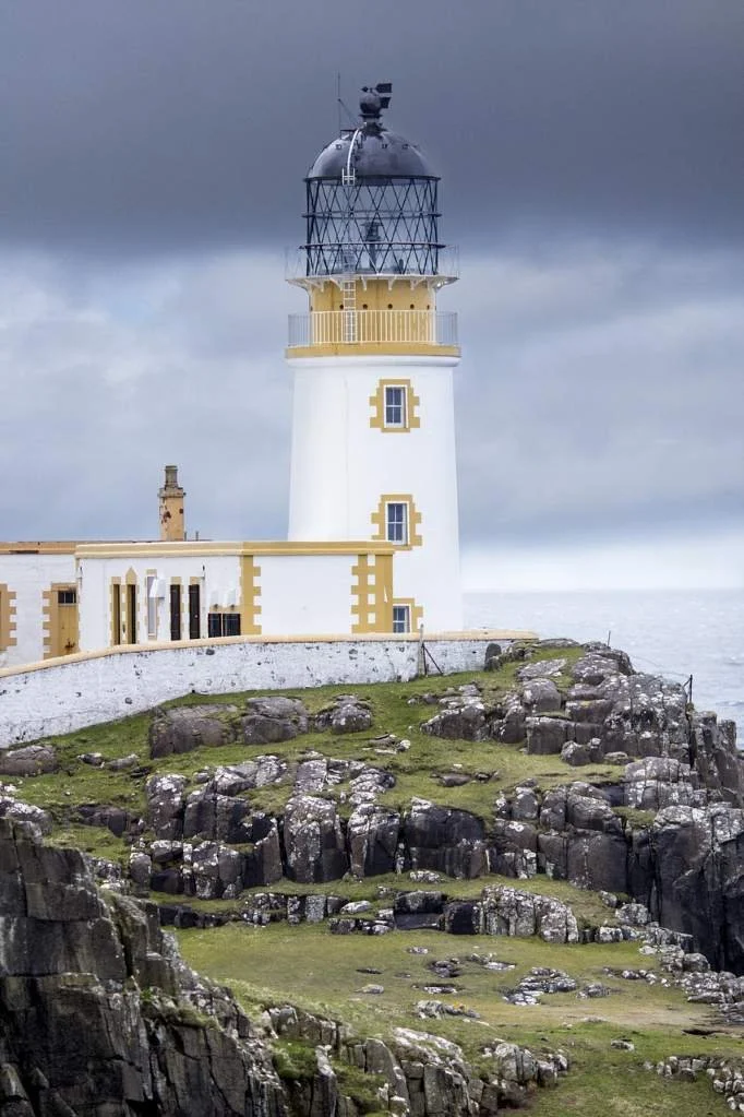
Neist Point — Skye’s Atlantic Edge
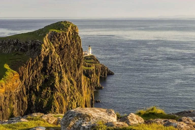
Neist Point is one of the most dramatic headlands in Scotland and one of the great scenic highlights of Skye’s west coast. Here, sheer cliffs drop into the Atlantic, waves crash far below, and the landscape feels exposed, vast and elemental.
The road ends in a small car park, and from there a steep footpath leads out onto the headland and down towards the lighthouse. This is not a place you simply stop and photograph from the car — it is a short but committed walk into one of Skye’s most powerful coastal landscapes.
The Lighthouse & Cliffs
The Neist Point Lighthouse was built in 1909 by David A. Stevenson of the famous Stevenson lighthouse-building family. It sits dramatically on a cliff-edge platform, reached by a path with steps cut into the rock.
From the headland you’ll see:
Towering vertical cliffs plunging into the sea
Long views across the Minch towards the Outer Hebrides
Constantly changing light, weather and sea conditions
Sunset is particularly spectacular here, when the cliffs glow and the Atlantic horizon feels endless.
-
Neist Point is one of the best places on Skye for seabird watching and marine life spotting:
Gannets, razorbills, guillemots and other cliff-nesting birds
Seals are often seen in the waters below
Dolphins and whales are occasionally spotted offshore
Bring binoculars if you have them — the cliff edges offer superb vantage points.
-
The walk is short but steep and exposed in places
Strong winds are common — wear sturdy footwear and warm layers
Keep well back from cliff edges, especially in wet or windy conditions
Allow 60–90 minutes for a relaxed visit with time to explore viewpoints
From Neist Point to the Cuillin — Coast to Mountains
Leaving the cliffs of Neist Point behind, the route turns south and begins a steady transition from Skye’s wild Atlantic edge into its mountainous heart. The road passes quieter stretches of coastline and open moorland, with short detours to places like the ancient stone structure of Dun Beag Broch and wide viewpoints over Gesto Bay.
The flat-topped silhouettes of MacLeod’s Tables soon appear ahead, before the route reaches Talisker Distillery at Carbost — a natural pause point on the shores of Loch Harport and the last taste of coastal Skye.
Beyond here, the landscape tightens and rises quickly. The peaks of the Black Cuillin dominate the horizon as the road drops into Glen Brittle, marking the start of Skye’s most dramatic mountain scenery and the gateway to the Fairy Pools and the Cuillin heartland.
-
Macleod's Tables are two flat-topped hills located on the Isle of Skye in Scotland. They are named Healabhal Mhòr (Big Macleod's Table) and Healabhal Bheag (Little Macleod's Table). These distinctive hills are characterised by their flat, plateau-like summits, which stand out against the rugged landscape of Skye. The Tables are popular hiking destinations, offering stunning panoramic views of the surrounding countryside and coastline from their summits. They are named after the Macleod clan, who have historical connections to the Isle of Skye.
Hiking up Macleod’s Tables entails a 7-mile (11 km) trek with an ascent of 682 meters, typically lasting between 4 to 6 hours. The journey begins through pathless, rugged moorland, with the Tables' steep grassy slopes greeting hikers. Upon reaching the summit, one gains a newfound appreciation for the surprisingly flat terrain. On clear days, the panoramic view from Healabhal Beag across Loch Bracadale to the Cuillin Mountains is truly spectacular, while Healabhal Mhòr offers vistas of Loch Dunvegan adorned with numerous islands.
Several legends shroud the history of the Tables.
In the 16th century, during a banquet hosted by King James V of Scotland, the Chief of the Clan MacLeod purportedly boasted of possessing a grander table than the King's. To prove his claim, the Clan Chief later invited the King and his guests to a banquet atop Healabhal Mhòr, solidifying his assertion.
Consider bringing along a picnic, complete with a plentiful supply of Scottish tablets, and reenacting the banquet yourself while revelling in the breathtaking views. You can almost envision the echoes of the Clan's festivities carried by the wind at the summit of the Table.
Another tale, dating back to the 6th century, involves the creation of the flat summits of Macleod’s Tables. Legend has it that upon his arrival on Skye, St Columba was denied hospitality. As a result, divine intervention purportedly removed the tops of the mountains, providing him with a bed for rest and a table for sustenance.
-
Talisker Distillery sits on the shores of Loch Harport, in the small village of Carbost, and is the only whisky distillery on the Isle of Skye. Founded in 1830, it produces one of Scotland’s most distinctive single malts — famous for its peppery, maritime character and subtle smoky notes.
Even if you’re not a big whisky drinker, the setting alone makes this a worthwhile stop: white buildings, sea loch views, and the Cuillin mountains rising behind.
Why it’s a good stop on this route
It sits perfectly on the west coast drive between Dunvegan / Neist Point and Glen Brittle
It provides a civilised pause between wild coastal scenery and mountain landscapes
Easy access, good parking, café/shop, toilets
What to see & do
Distillery tours (book ahead in peak season) explaining the Skye whisky-making process
Tasting sessions of Talisker expressions
Visitor shop with distillery exclusives and gifts
Short walks around Loch Harport for photos and a leg stretch
Practical notes
Parking available on site
Allow 45–90 minutes depending on whether you tour or just visit the shop
Very popular in summer — booking recommended
Talisker works best as a mid-journey anchor point before heading into the Cuillin heartland.
The Cuillin & Glen Brittle — Into Skye’s Mountain Heart
This is the moment the journey leaves Skye’s coast behind and enters its most dramatic interior. The road folds inward beneath the Black Cuillin, where sharp ridges, dark corries and fast-running rivers dominate the landscape.
Here, distances are short but the scenery is intense. You move from whisky shores and sea lochs into one of the wildest mountain regions in Britain, with short walks, powerful viewpoints and some of Skye’s most iconic landscapes packed into a relatively small area.
This section links the west coast back to the island’s interior, before returning east via Sligachan towards Broadford and the Sleat Peninsula.
Glen Brittle — The Gateway to the Cuillin
Glen Brittle sits beneath the highest and most dramatic section of the Black Cuillin. It feels immediately different from the rest of Skye: steeper, darker, more enclosed, and far more mountainous.
The glen is framed by razor-edged ridges and deep corries, with a single road running down to Loch Brittle and its wild beach. It is one of the main access points for walkers and climbers heading into the Cuillin, but also works beautifully as a scenic destination in its own right.
Short walks, waterfalls and shoreline views make this a rewarding stop even if you have no intention of climbing.
Cuillin Mountains
-
The Cuillin Mountains are one of the most dramatic and demanding mountain ranges in the UK, famous for their jagged ridges, steep corries and dark volcanic rock. They are a magnet for experienced mountaineers and climbers, but they also offer several superb lower-level and mid-level walks that don’t require technical skills.
From Glen Brittle, a network of paths leads into the heart of the Black Cuillin, climbing towards high corries, waterfalls and mountain lochans. One of the finest classic walks is into Coire Lagan, a spectacular corrie with a dark lochan sitting beneath the towering peaks of Sgurr Alasdair, Skye’s highest mountain. Even without climbing any summits, this walk gives you a true sense of the scale and drama of the Cuillin.
For shorter or less demanding outings, there are excellent walks to features such as Eas Mòr, a powerful waterfall on the Allt Coire na Bannachdich, and to viewpoints on lower surrounding hills like Bidein Druim nan Ramh (869 m), which offers wide views without the technical terrain of the main ridge.
Important to know:
The Cuillin are serious mountains. Weather changes fast, paths can be rough or unclear, and rock can be slippery.
Proper footwear, waterproofs and navigation skills are essential, even for shorter walks.
The full Cuillin Ridge and many summit routes are scrambling or climbing routes and should only be attempted by experienced mountaineers or with a guide.
For most visitors, the best experience is to enjoy one or two of the classic corrie walks or waterfall routes — enough to feel the power of the Cuillin without taking unnecessary risks.
-
Rubha an Dùnain is an ancient settlement. Resting at the base of the towering Cuillin mountains and boasting sweeping vistas of The Hebrides, Rubh’ an Dùnain (Gaelic: Promontory of the little fort; Pron: roo-an-doonan) is a secluded landscape that remained largely concealed from public sight for over 160 years. This coastal peninsula is home to ancient archaeological sites, including Neolithic chambered cairns, Iron Age forts, and Viking settlements, reflecting the area's long-standing human presence. Historically, Rubha an Dùnain served as a strategic location for trade, fishing, and defence, shaping its cultural significance over time.
Today, visitors can explore the historic ruins and scenic landscapes of Rubha an Dùnain on foot to discover a fascinating glimpse into Skye's past. As you wander through the rugged terrain, you'll encounter remnants of ancient structures and stunning coastal vistas, providing a tangible connection to the island's storied history.
The Fairy Pools — Skye’s Most Famous Mountain Walk
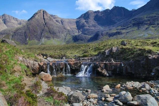
The Fairy Pools sit in the lower reaches of Glen Brittle, where clear mountain water cascades through a series of turquoise pools and waterfalls beneath the Cuillin.
This is one of Skye’s most visited spots, and for good reason: the combination of jagged peaks, constantly changing light and vivid water colours is extraordinary.
For most visitors, this is best treated as a scenic walk and photography stop, rather than a swimming destination.
Practical notes
Return walk: approx 2.4 km
Time: 40 minutes to 1.5 hours depending on pace and conditions
Best time: early morning or later afternoon
Footwear: waterproof boots strongly recommended
Weather: Cuillin conditions change fast
Across the Cuillin Foothills — The High Road to Sligachan
Leaving Glen Brittle, the road climbs and curves eastward, skirting the northern flanks of the Black Cuillin. This is one of Skye’s most scenic interior drives, with constant views of steep ridges, hanging corries and long glacial valleys.
This section is less about specific stops and more about the sense of crossing through a mountain landscape — slow, winding and visually powerful.
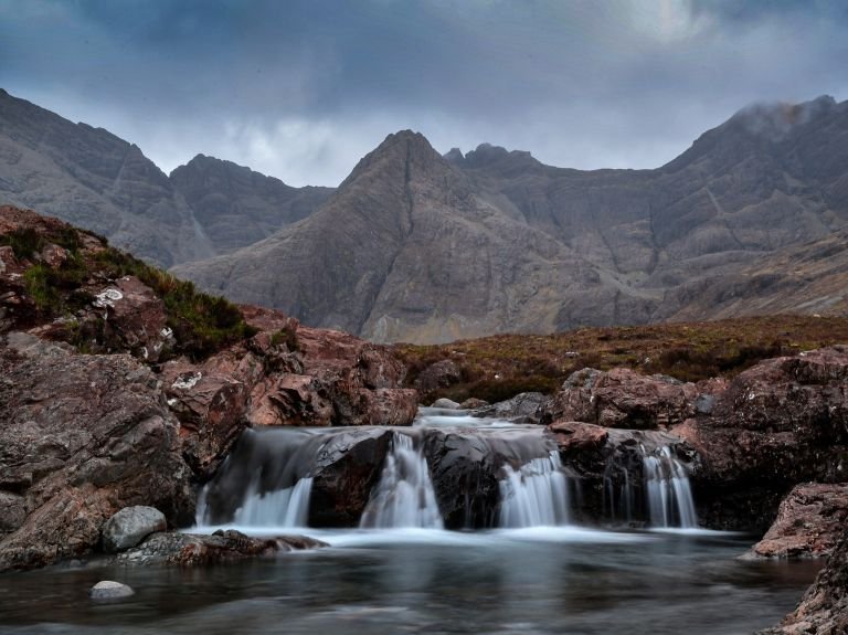
Sligachan — Water, Mountains and a Natural Crossing Point
Sligachan sits at the meeting point of several of Skye’s great landscapes and has long been a natural crossroads.
The old stone bridge and river pools beneath the Cuillin make a perfect final stop in this section. The views here — back towards the jagged ridge — are some of the most recognisable on the island.
A short walk around the bridge and river gives you a last close look at the Cuillin before the road continues east towards Broadford and the Sleat Peninsula.
Sligachan — Water, Mountains and a Natural Crossing Point

Sligachan is one of Skye’s great meeting places — where roads, rivers and mountain routes come together beneath the dark wall of the Cuillin. For centuries it has been a natural crossing point, a resting place, and a gateway into the heart of the island’s wildest landscapes.
The old stone bridge over the River Sligachan is the focal point. From here, the views back towards the jagged Cuillin ridge are among the most iconic on Skye — a final, powerful reminder of the mountains you’ve just travelled through. Below the bridge, clear pools and fast-flowing water spill over smooth rocks, creating a scene that is both dramatic and strangely peaceful.
A short wander around the bridge and riverbanks brings you to the Sligachan Waterfalls, where the river breaks into a series of cascades and pools beneath the open sky. It’s an easy and rewarding stop, though care is needed on wet or slippery rocks.
Sligachan also marks a psychological shift in the journey. The high drama of the Cuillin begins to soften, the roads open out, and the landscape starts to change character again.
From here, the route turns south and east, heading back towards Broadford and onward to the Sleat Peninsula, leaving the mountains behind and moving into a greener, gentler corner of Skye.
This is a natural place to pause, reflect — and then continue the journey with the next part - click here to jump to the Sleat Peninsula.
Uncover More Map
The Uncover More map highlights key points of interest, scenic viewpoints, hidden gems, and much more along the recommended route. To make the most of it, use the map in conjunction with the destination information, and explore additional options in the area you’re visiting to discover even more experiences.
If your iPhone doesn’t load via the Google Map App via the button, check out the Help page for how to update your phone or copy and paste the link into your browser: https://bit.ly/Skye-Uncover
Isle of Skye Last updated: 24 March 2026
Some links may earn Uncover Britain a small commission at no extra cost to you. This helps support the ongoing creation, review and presentation of our road trip guides.
Route information and listings are provided for general guidance only. Always use your preferred navigation system and check official websites to confirm suitability, opening times and the latest details before travelling.
Our guides are reviewed regularly and supported by a mix of editorial research and digital tools to help keep content clear and up to date. If you spot anything that needs updating, we’re always glad to hear from you.