

Distance: 160 miles (258 km) with drive time of around 5 hours, 30 minutes
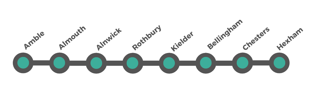
Amble > Alnmouth > Alnwick > Rothbury > Harbottle > Simonside valley road > Kielder > Bellingham > Chesters > Hexham
Customisable and Live Navigation via Google Maps - click here.
Plus the following spurs / detours are included:
Rothbury Spur > National Park Scenic Spur adds ≈ 20 miles to the loop with drive time of about 40–50 minutes
Rothbury Spur > Cragside Britain’s First Electric House
Hadrian’s Wall Spur > From Hexham adds ≈ 42 miles to the loop with drive time of about 1 hour 15 minutes
Newcastle upon Tyne Spur > From Hexham adds ≈ 55 miles to the loop with drive time of about 1 hour 30 minutes
For Castles & Coast - this loop connects at Amble or Alnwick
Northumberland Inland Valleys, Roman Frontier & Forest Loop
This inland Northumberland circuit is inspired by the landscapes and quiet backroads that have made the Northumberland 250 a favourite with touring drivers — but presented here as a coherent loop that begins and ends at the coast.
Leaving Amble behind, the road quickly trades beaches for river valleys, sheep-dotted hillsides and empty B-roads. It winds through Coquetdale, climbs into heather moorland around Simonside, enters the deep forests of Kielder, follows the North Tyne south, and meets Hadrian’s Wall where Roman history sits high above sweeping views. From Hexham, gentle country lanes lead you back east to the sea.
It’s not a drive for ticking off landmarks. It’s a drive for enjoying the road itself — the spaces between places — and seeing a side of Northumberland many visitors never reach.
Before arriving in Amble, pause at the wide, dune-backed sands of Druridge Bay. This long, open stretch of beach is often quiet, with marram grass, rolling surf and big skies — a calming introduction to Northumberland’s coast.
From here, it’s a short, easy drive north into Amble’s friendly harbour, where fishing boats, seabirds and estuary views welcome you to the start of the route.
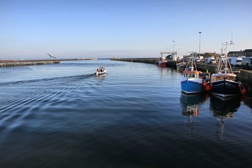
Amble — Harbour Life, Islands and Wide Sands
Amble is a friendly working harbour at the mouth of the River Coquet where fishing boats, seabirds and big coastal skies set the tone for this road trip. It’s an easy place to arrive, park, wander and breathe in the sea air before heading inland. With a small marina, a sweep of sandy beach at Little Shore, and views across the water to Warkworth Castle, Amble feels both open and compact — a perfect starting point.
What to see and do
Browse the harbourside seafood pods for fresh, local lunches
Walk the pier for views toward Coquet Island and its lighthouse
Stroll along Little Shore beach and the dunes south of the harbour
Follow the River Coquet path for views back to Warkworth Castle (included on the coast route)
Visit the marina and watch fishing boats unload the day’s catch
Enjoy cafés, ice cream and easy harbourfront wandering before setting off inland
Leaving Amble, the road hugs the coast for a few easy miles, with dunes, open fields and wide sea views to your right. It’s a gentle, unhurried stretch that keeps the water in sight before the River Aln estuary begins to open out ahead.
Soon the pastel houses and grassy dunes of Alnmouth come into view — a soft, colourful pause between harbour life and the inland hills beyond.
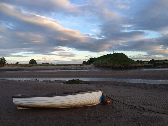
Alnmouth—Estuary Colours, Dunes and Big Skies
Set where the River Aln meets the North Sea, Alnmouth is a postcard-bright village of pastel houses, grassy dunes and a vast sandy beach that seems to stretch forever at low tide. It’s calm, airy and beautifully positioned between coast and countryside — a gentle pause before the road turns inland toward the hills. The wide estuary, the soft light and the sense of space make this one of the most photogenic stops on the route.
What to see and do
Walk out across the expansive Alnmouth Beach and dune grasses
Follow the estuary edge for reflections and birdlife along the River Aln
Wander the colourful village streets and small independent shops
Pause at a café overlooking the estuary and boats on the tide
Take in sunset light across the sands before continuing to Alnwick
Leaving Alnmouth, the road gently follows the River Aln inland. The dunes and wide sands give way to open farmland and hedgerows, and within a few quiet miles the first hints of stone walls and rooftops appear ahead.
This short stretch is a natural change in character — from sea air and estuary light to market-town streets and medieval history — as you arrive in Alnwick, the inland gateway to Northumberland’s hills.
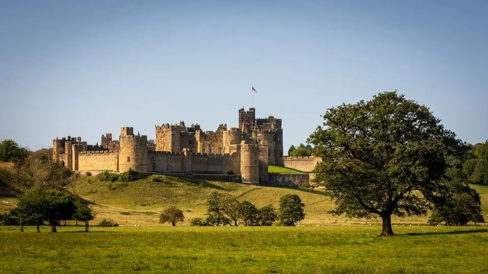
Alnwick — Cobbled Streets, Books and Gardens
Alnwick is a handsome market town of stone buildings, cobbled lanes and independent shops, sitting neatly between coast and countryside. It’s an easy place to slow down for an hour or two — browse, wander and enjoy the atmosphere — before the road begins to climb inland toward the hills. With cafés, bookshops and gardens, Alnwick offers a relaxed pause that feels distinctly Northumbrian without needing to rush.
What to see and do
Visit Alnwick Castle (see below)
See Bondgate Tower (Hotspur Gate), a 15th-century stone gatehouse built after Henry V granted the town a licence to crenellate its walls in 1434
Explore the stories of the border conflicts at Bailiff Gate Museum, home to artefacts, documents and audio-visual displays
Catch a performance or film at Alnwick Playhouse, a lively arts venue with an eclectic programme
Browse Barter Books in the old railway station, complete with model railway, poetry lines and the popular Station Buffet café
Wander through Alnwick Garden with its themed planting, water features and contemporary design
Walk in Hulne Park, a vast walled estate of parkland, woodland, priory ruins and Brizlee Tower viewpoints
Ride a heritage diesel service with the Aln Valley Railway, restoring part of the old Alnwick–Alnmouth line
Alnwick Castle - Medieval Power, Film Fame and Living History

Alnwick Castle, located in the market town of Alnwick in Northumberland, is one of the most iconic and historically significant castles in the country. Alnwick Castle has a rich history dating back to the Norman period, with the earliest parts of the castle constructed in the 11th century. It was built to defend the northern border of England against Scottish invaders and served as a formidable stronghold during the medieval period.
Since 1309, Alnwick Castle has been the ancestral seat of the Percy family, who are the Earls and Dukes of Northumberland. The castle has been continuously inhabited by the Percy family for over 700 years, making it one of the oldest inhabited castles in England.
In addition to its historic significance, Alnwick Castle is surrounded by beautifully landscaped gardens and grounds. The Alnwick Garden, adjacent to the castle, features stunning formal gardens, water features, and contemporary art installations, offering visitors a tranquil oasis to explore and enjoy.
The Castle has a starring role as Hogwarts School of Witchcraft and Wizardry casts a hint of magic over the grounds. Have a guided tour led by Ron Weasley and take a broomstick lesson on the very spot where Harry, Ron, and Hermione learned to fly. Harry Potter aside, get lost in the history of medieval architecture and opulent Italianate State Rooms of the Duchess of Northumberland’s family home.
Today, Alnwick Castle is open to the public as a major tourist attraction, offering guided tours, historical reenactments, and family-friendly activities. Visitors can explore the castle's grand interiors, including the State Rooms, Percy Tenantry Museum, and medieval dungeons, and learn about its fascinating history through interactive exhibits and displays.
Leaving Alnwick, the road begins to trade market-town streets for open countryside. Hedgerows give way to wider views, the land starts to rise, and before long the Cheviot foothills appear ahead. This is where the character of the journey changes noticeably — from coast and castles to river valley, sheep pastures and quiet B-roads — as you arrive in Rothbury, the gateway to Coquetdale.
Rothbury — River Valley Gateway to the Hills
Rothbury sits in a wide bend of the River Coquet, surrounded by green hills and open skies. It’s a peaceful, attractive village that feels properly rural without being remote — a natural pause before the road narrows and begins to follow the river deeper into Coquetdale. With cafés, small shops and riverside walks, Rothbury is an ideal place to slow down before continuing along one of the quietest and most scenic roads in Northumberland.
What to see and do
Stroll along the River Coquet for open valley views and stepping stones
Browse independent shops and cafés on the high street
Enjoy the village green and surrounding hill scenery
Take a short walk into the foothills for wider views back across Coquetdale
Visit Cragside nearby (included in this guide as a spur detour)
Rothbury National Park Scenic Spur
Incorporating Coquetdale Valley and Simonside Moorland Road
From Rothbury, you have a rare opportunity to experience the same landscape from two completely different perspectives — first from the quiet river valley floor, then from the high heather moorland above.
This scenic spur explores the heart of Northumberland National Park without adding complicated mileage to your route. Instead, it offers two short, memorable out-and-back drives that reveal why this part of Northumberland feels so wild, spacious and unspoilt.
Part 1 — Coquetdale Valley (valley floor)
Leave Rothbury on the B6342 and follow the River Coquet upstream into Coquetdale. This is a peaceful stretch of road where sheep graze in open fields, wooded riverbanks line the tarmac, and the Cheviot foothills rise gently ahead.
Pause near Thrum Mill, where stepping stones cross the river and the valley feels at its most tranquil. This spot is marked on the map as:
Coquetdale Scenic Road – B6342 - 55.3349, -2.0616
Return to Rothbury after enjoying the valley views.
Part 2 — Simonside Moorland Road (ridge views)
Back in Rothbury, take the minor road that climbs quickly onto the open moorland of the Simonside Hills. Within minutes the river valley drops away behind you and the landscape opens into sweeping heather, rocky outcrops and far-reaching views across Northumberland.
Look out for:
Lordenshaw Hillfort
The Drake Stone
This spot is marked on the map as: Simonside Moorland Road View 55.3083, -1.9957
After taking in the moorland scenery, descend back to Rothbury and continue the main inland loop toward Harbottle.
Together, these two short drives show Coquetdale from below and above — a perfect introduction to the scale, space and beauty of Northumberland National Park.
Spur off route — Cragside: Britain’s First Electric House
Where to leave the Northumberland 250 loop
As you pass through Rothbury on the B6342, do not continue straight toward Harbottle just yet. Instead, turn south following signs for Cragside. Within minutes, the road climbs into wooded hills and you enter the Cragside estate.
This is a short, simple out-and-back detour. After your visit, return the same way to Rothbury and rejoin the inland loop toward Harbottle.
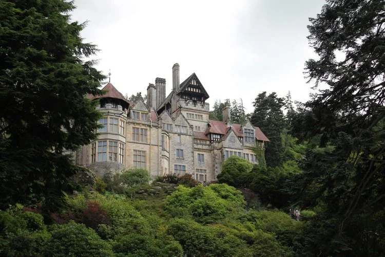
National Trust’s Cragside sits in a steep, wooded valley above Rothbury and feels completely different from the open river landscapes you’ve just driven through. Lakes, winding estate roads, conifer forests and rocky outcrops surround a remarkable Victorian house that changed the course of modern living.
This is one of the most fascinating country houses in Britain — not just for its setting, but for its story.
Drive the scenic estate carriage road around lakes and forest viewpoints
Explore the house where many modern technologies were first demonstrated
Walk woodland trails through rhododendrons, conifers and rocky crags
Visit the Power House to understand how the estate generated its own electricity
Picnic beside the lakes or at designated viewpoints
Spot red squirrels and woodland birds in the surrounding forest
-
The vision of William Armstrong
Cragside was the home of Victorian inventor and industrialist William Armstrong, later Lord Armstrong, whose engineering work helped power the Industrial Revolution.The first house lit by hydroelectricity
In the 1870s, Armstrong used water from the estate lakes to generate hydroelectric power, making Cragside the first house in the world to be lit by electricity.A laboratory for modern living
Many innovations were tested here first, including early central heating, hydraulic lifts, and advanced plumbing systems — turning the house into a working experiment in future living.Designed with the landscape
Rather than imposing on the valley, Cragside was built to blend into it. The surrounding forests were largely planted by Armstrong himself, transforming a rocky hillside into the wooded estate you see today.
Leaving Rothbury, the road quickly narrows as it joins the B6342 and begins to follow the River Coquet upstream. This is where the drive settles into a gentle rhythm: sheep in the fields, wooded riverbanks, rolling hills ahead and very little traffic.
You’re now on what many consider one of the finest quiet-road stretches in Northumberland — the Coquetdale Scenic Road. About halfway along this section (the spot marked on your map as Coquetdale Scenic Road – B6342), the tarmac runs tight beside the river with open valley views in both directions.
As the valley widens and the hills begin to rise, the tiny hamlet of Harbottle comes into view, sitting quietly at the edge of the Cheviot foothills and marking the point where this peaceful river drive begins to turn toward moorland and forest beyond.
Harbottle — Edge of the Cheviots, Quiet and Remote
Harbottle is little more than a scattering of stone cottages, a church and open pasture at the foot of the Cheviot Hills — and that’s exactly its charm. After the gentle river valley drive from Rothbury, arriving here feels like reaching the edge of something wilder. The hills begin to close in, the road feels smaller, and the sense of remoteness grows.
This is a natural pause point before the landscape changes again, as the route leaves the Coquet valley behind and begins to climb toward moorland and forestry.
What to see and do
Walk a short stretch along the quiet lane for views up into the Cheviot foothills
Explore the ruins of Harbottle Castle overlooking the village
Enjoy the peaceful setting and open skies before continuing west
Take a moment to appreciate how traffic-free this part of Northumberland feels
From here, the road begins to rise gently and the character of the drive shifts from river valley to heather moorland as you head toward Simonside and beyond.
Leaving Harbottle, the road narrows and begins to feel wonderfully remote. This is one of the quietest stretches of the entire journey, where sheep outnumber cars and the River Coquet slips in and out of view beside the tarmac. You are now travelling along the B6342 through Coquetdale, a section often described as one of the most scenic rural drives in Northumberland.
A little further on, the landscape subtly changes. The valley begins to rise, the hills close in, and the heather-covered slopes of Simonside Hills appear ahead. If you glance at your map, this is where you pass the Simonside Moorland Road View — an open stretch of road with big skies and wide views across the Cheviot foothills.
From here, the route turns westward and the scenery shifts again. Moorland gives way to forestry, the air cools, and long straight roads begin to cut through dense woodland as you approach the vast landscapes surrounding Kielder Water & Forest Park.
This section — Coquetdale river valley, Simonside moorland, then forest approach — is a perfect example of why this inland route feels so varied and memorable.
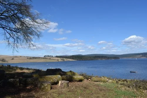
Kielder Water & Forest Park — Forest Roads, Dark Skies and Vast Water
Kielder is where the landscape turns big, quiet and immersive. Home to the largest man-made lake in Northern Europe and some of the darkest skies in England, this is a place designed for exploration. Long forest roads thread between water, woodland and art installations, creating a playground for walkers, cyclists and anyone who simply enjoys being outdoors.
The scale of the forest, the stillness of the water and the quality of the night sky make Kielder feel wonderfully remote — a striking contrast to the river valleys and moorland you’ve driven through to reach it.
What to see and do
Start at Tower Knowe Visitor Centre near the dam for orientation, views and lakeside walks
Explore the forest and art installations around Kielder Castle with trails, facilities and information
Visit Bakethin Nature Reserve for wildlife watching and peaceful lakeside views
Learn about migrating salmon at the Kielder Salmon Centre
Walk or cycle sections of the lakeside trails with expansive views across the water
Look out for red squirrels, ospreys and other wildlife along the trails
Return after dark for stargazing at Kielder Observatory, one of the best places in England to experience the night sky
Camping at Kielder: Inside the Park - for seasonal pitches and all tourers stay at Kielder Waterside Caravan Park. Nearer to the Castle is Kielder Caravan and Camping Site– a riverside site for tents, touring caravans, and campers. Please note - there is no wild camping allowed at Kielder. Find a range of campsites just outside the park here.
Dark Skies: The Campaign for the Protection of Rural England (CPRE) says that the star-studded skies above Kielder Water & Forest Park are the darkest in England. They have been awarded Gold Tier Dark Sky Park status by the International Dark Skies Association (IDA) in December 2013 – the highest accolade the IDA can give. See below for more details on star gazing in Northumberland.
Leaving Kielder, the route joins the B6320 and begins to follow the River North Tyne south toward Bellingham. This is one of the loveliest hidden stretches of the drive, where the road runs beneath trees, the river appears beside you in flashes, and the pace feels calm and unhurried.
This area is marked on the map as: North Tyne Valley Scenic Road – B6320
55.1647, -2.4452
Look out for:
Tree-lined riverside bends
Reflections on still water
Occasional open views across the valley
Almost no traffic
This is the forest giving way to settled river valley again before you arrive in Bellingham.
Bellingham — Riverside Calm and Stone Bridges
Bellingham sits neatly on the River North Tyne, surrounded by woodland and gentle hills. After the forest roads of Kielder, arriving here feels like returning to a settled, lived-in landscape. Stone cottages, a graceful bridge and riverside walks make this a relaxed and welcoming pause before the route continues south toward Hadrian’s Wall.
What to see and do
Walk along the River North Tyne and across the stone bridge for classic views
Browse small shops and cafés in the village centre
Visit Bellingham Heritage Centre to learn about the area’s rural and border history
Enjoy the calm riverside setting before rejoining the road toward the Roman frontier
Hareshaw Linn - A Hidden Waterfall
Hareshaw Linn is a picturesque waterfall nestled near the village of Bellingham, approximately 17 miles north of Hexham. This scenic woodland trail and waterfall is one of Northumberland’s most beautiful hidden gems, offering a peaceful walk through ancient forests, across wooden bridges, and along a gently flowing burn leading to the dramatic cascade.
Highlights of Hareshaw Linn include a scenic waterfall – A breathtaking 30-foot cascade, surrounded by moss-covered rocks and lush greenery and woodland walk – The 3-mile (4.8 km) round-trip walk takes about 2 hours to complete and features six charming bridges along the route.
Home to red squirrels, great spotted woodpeckers, and rare bats, along with over 300 species of mosses and lichens, making it a Site of Special Scientific Interest (SSSI). Rest along the trail at designated seating areas, perfect for a break surrounded by nature.
How to Get to Hareshaw Linn: From Hexham (17 miles | 35 minutes) take the B6320 road north towards Bellingham. Once in Bellingham, follow signs to the Hareshaw Linn car park, located just off the main road. From Kielder (17 miles | 35 minutes) take the C200 road southeast towards Bellingham. Upon arrival, follow signs to the Hareshaw Linn trailhead, where the walk begins.
Bellingham to Chesters (river valley to Roman frontier)
Leaving Bellingham, the road continues to follow the River North Tyne south on the B6320. Trees line the roadside, the water appears and disappears beside you, and the drive feels calm and shaded after the openness of moorland and forest.
Gradually, the valley widens and signs of the Roman frontier begin to appear. As you approach the Tyne crossing near Chollerford, the landscape opens out and you arrive at one of the most atmospheric sites along Hadrian's Wall — Chesters Roman Fort.
Chesters Roman Fort — Riverside Ruins on Hadrian’s Wall
Chesters is one of the best-preserved Roman cavalry forts in Britain, set in a peaceful riverside location that feels far removed from modern roads. The remains of bathhouses, barracks and command buildings sit among trees and open grassland beside the River North Tyne, giving a real sense of how this frontier once functioned.
It’s a quieter, more contemplative Hadrian’s Wall stop than the dramatic escarpments further west, but no less fascinating for it.
What to see and do
Explore the extensive fort remains and bathhouse complex
Walk down to the River North Tyne for peaceful views
Visit the museum displaying Roman artefacts found on site
Follow short walking paths along the line of the Wall before continuing to Hexham
Leaving Chesters Roman Fort, the road follows the River North Tyne a little further before gently widening and returning to more familiar countryside. The Roman frontier slips quietly into the background as fields, hedgerows and open views reappear.
Within a few easy miles, the handsome streets and abbey towers of Hexham come into view — a welcoming market town pause after the calm riverside ruins.
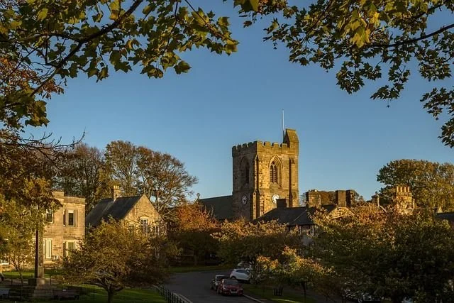
Hexham — Abbey Town on the Roman Frontier

Image credit: Hexham Abbey
Hexham sits handsomely on the south bank of the River Tyne and makes a natural pause point on the inland loop, especially for those exploring Hadrian's Wall nearby. Stone streets cluster around a magnificent abbey, independent shops line the market square, and riverside parks provide gentle places to wander after time on the road.
This is a town shaped by Romans, monks, border wars and industry — and that layered history is visible everywhere you look.
What to see and do
Visit Hexham Abbey, one of the earliest seats of Christianity in England, with Norman architecture, intricate carvings and peaceful cloisters
Explore crime and punishment history at the Hexham Old Gaol, one of the oldest purpose-built prisons in England
Wander the lively market square for independent shops, cafés and regular markets
Stroll through Sele Park and along the River Tyne at Tyne Green Country Park
Experience race day at Hexham Racecourse, set in a natural amphitheatre of countryside
Begin National Park exploration at The Sill: National Landscape Discovery Centre, a gateway to walks along the Wall including routes to Steel Rigg and Cawfields
Take a short trip to Museum of Classic Sci-Fi in nearby Allendale for a quirky, memorable visit
-
Hexham’s story reaches back to Roman times when Dere Street passed nearby and forts guarded the frontier. In AD 674, St Wilfrid founded the original abbey here, establishing Hexham as a major religious centre in Anglo-Saxon England. The town endured Viking raids, Norman rebuilding, medieval market prosperity and centuries of Anglo-Scottish border conflict, all of which left their mark.
Today, Hexham blends this deep history with a welcoming market-town atmosphere, making it an ideal place to pause before continuing east toward the coast.
-
Hexham is compact and easy to explore on foot once parked. Most key sights — the Abbey, market square, Old Gaol and riverside parks — are within a few minutes’ walk of each other.
Best places to park
Wentworth Car Park
Large, central, and ideal for the Abbey, market square and Old Gaol. Very convenient for short visits.Beaumont Street Car Park
Close to the town centre shops and cafés. Good alternative if Wentworth is busy.Tyne Green Country Park Car Park
Best if you want riverside walks or a picnic stop before/after exploring the town. A pleasant 10-minute walk into the centre.Railway Station Car Park
Often quieter and only a short walk into town.
Tips
Hexham can be busier on market days and weekends in summer — aim to arrive before late morning if possible.
Most car parks are pay-and-display with card/contactless options.
Toilets are available near the main car parks and in the town centre.
If you’re continuing to the Hadrian’s Wall spur, it’s easy to rejoin the road network from any of these car parks without navigating back through tight streets.
Park once, explore on foot, and enjoy the relaxed pace of this historic market town.
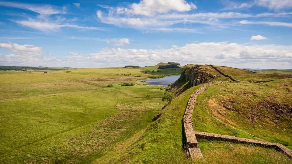
Spur Detour — Hadrian’s Wall Escarpment & Forts
Leave the inland loop just after Hexham and head west on the B6318 (Military Road) — the road that runs along the crest of the Whin Sill following the line of Hadrian's Wall.
This is the most dramatic, best-preserved and most walkable section of the Wall. The main loop covers Chesters Roman Fort, which is peaceful and riverside.
This spur takes you to the high escarpment Wall — the iconic views, cliff-top walking, milecastles and turrets that most people picture when they think of Hadrian’s Wall.
The key stops in order (westbound from Hexham)
Housesteads Roman Fort
One of the most complete Roman forts in Britain, sitting directly on the Wall with wide views.Steel Rigg and Sycamore Gap
The most photographed stretch of the Wall. Although the famous sycamore tree was felled in 2023, this remains the most dramatic viewpoint along the frontier.Cawfields Quarry / Walltown Crags
Crags, lakes and long surviving lengths of Wall in open scenery.
Explore Northumberland’s Inland Heritage with English Heritage
Northumberland’s inland landscapes are rich in historic sites — from Roman forts along Hadrian’s Wall to castles and priory ruins hidden within valleys and countryside.
These sites sit naturally within the inland section of the route, making them easy additions as you explore valleys, market towns and the Roman frontier.
Annual membership starts from £53 — with 15% off using code AFFEH1526 until 31.12.2026.
Membership often pays for itself in just 2–3 visits, especially when exploring multiple sites along your route.
Get 15% Off MembershipClosing the Inland Loop — Hexham back to the Coast
Leaving Hexham, the road turns gently eastward and the landscape begins to soften once more. After river valleys, moorland ridges, forest roads and the stone line of Hadrian's Wall, this final stretch feels calm and spacious.
Country lanes and open farmland lead you gradually back toward the coast. The hills fall away behind you, hedgerows replace heather, and before long the familiar sea air returns as you approach Amble.
You’ve now seen Northumberland from the inside — its quiet National Park landscapes, hidden valleys, forest roads and Roman frontier. From here, the journey changes character completely as you prepare to follow the shoreline north into one of the most spectacular coastal drives in England.
The next section takes you from harbour towns to ruined castles, fishing villages to tidal islands — the classic Castles & Coast route that contrasts beautifully with the solitude of the inland loop.
Spur Detour — Newcastle upon Tyne: Bridges, Quayside and Culture
Where to leave the inland loop
The easiest and most logical point to detour for Newcastle is from Hexham.
Instead of turning east back toward Amble at the end of the inland loop, follow the A69 eastbound for around 25 miles straight into Newcastle. It’s a fast, simple road with no complicated navigation, and it drops you directly into the city on the River Tyne.
After your visit, you can rejoin the coastal section by taking the A1 north to re-enter the route near Morpeth / Druridge Bay / Amble.
If you’d like to add a city contrast to Northumberland’s wild landscapes, Newcastle upon Tyne makes an easy and rewarding detour. Famous for its elegant bridges, lively Quayside, historic streets and cultural venues, the city offers a completely different pace before you return to coast and castles.
A short run along the A69 from Hexham brings you from Roman frontier countryside to one of northern England’s most characterful cities in under an hour.
-
Newcastle-upon-Tyne, often simply referred to as Newcastle, is a vibrant city in northeastern England with a rich and fascinating history. The city's name originates from its location along the River Tyne and the presence of a medieval castle built by the Normans in the 12th century. The "New Castle" served as a defensive stronghold, strategically positioned to protect the northern border of England against Scottish invasions.
During the Middle Ages, Newcastle grew in importance as a bustling market town and a prominent centre for trade. Its proximity to the North Sea and the navigable River Tyne made it a vital hub for maritime commerce. The city thrived on industries such as coal mining, shipbuilding, and manufacturing, fueling its economic prosperity.
Newcastle played a significant role in the Industrial Revolution, particularly in the 18th and 19th centuries. The city's abundance of coal reserves fueled the growth of the coal mining industry, leading to advancements in steam power and the development of the railway network. The famous engineer George Stephenson, a native of the region, played a pivotal role in the creation of the world's first locomotive, the "Blucher," which operated in the collieries around Newcastle.
The iconic Tyne Bridge, a symbol of the city, was completed in 1928. Designed by Mott, Hay, and Anderson, it spans the River Tyne, connecting Newcastle with its neighbouring town, Gateshead. The bridge stands as a testament to the city's engineering prowess and serves as a vital transportation link.
Newcastle has a proud cultural heritage and is renowned for its vibrant arts and music scene. The city is home to esteemed cultural institutions such as the Theatre Royal, which opened in 1837 and is one of the oldest working theatres in the country. Additionally, Newcastle is famous for its lively nightlife, with numerous bars, clubs, and music venues that have fostered a thriving music and entertainment culture.
Today, Newcastle is a modern metropolis that seamlessly blends its industrial past with contemporary urban development. Visitors to the city can explore its historic architecture, including the medieval St. Nicholas' Cathedral, the Grainger Town area with its elegant Georgian buildings, and the revitalised Quayside, lined with trendy bars, restaurants, and cultural venues.
-
Morning: Historic Landmarks & River Views
Newcastle Castle – Explore the fortress that gave the city its name. Climb to the top for panoramic views of the Tyne.
Grey Street & Grainger Town – Wander through Newcastle’s most beautiful Georgian architecture, home to shops and cafés.
Quayside & The Tyne Bridges – Walk along the River Tyne, admire the iconic Tyne Bridge, and cross the Gateshead Millennium Bridge.
Midday: Culture & Local Flavours
The Baltic Centre for Contemporary Art – A free art gallery in a converted flour mill with rooftop views over the city.
Lunch at the Quayside or Grainger Market – Try Geordie comfort food like a stottie cake or fresh seafood at a riverside restaurant.
Afternoon: Museums & Unique Experiences
Victoria Tunnel – Take a guided tour through this underground 19th-century coal tunnel used as an air raid shelter in WWII.
Discovery Museum – Learn about Newcastle’s industrial past, including the world’s first steam turbine ship, the Turbinia.
Ouseburn Valley – Explore Newcastle’s creative quarter, home to street art, indie cafés, and the Ouseburn Farm.
Evening: Food, Drink & Views
Dinner on Grey Street or High Bridge – Enjoy modern British cuisine, international dining, or traditional pub grub.
The Tyne Bar or The Free Trade Inn – Relax with a local ale while overlooking the River Tyne.
The Sage Gateshead – If time allows, catch a live music performance at this world-class venue.
This itinerary gives you a well-rounded taste of Newcastle, combining history, culture, and great food in just one day.
Uncover More Map
The Uncover More map highlights key points of interest, scenic viewpoints, hidden gems, and much more along the recommended route. To make the most of it, use the map in conjunction with the destination information, and explore additional options in the area you’re visiting to discover even more experiences.
If your iPhone doesn’t load via the Google Map App via the button, check out the Help page for how to update your phone or copy and paste the link into your browser: https://bit.ly/northumberland-uncover
There are over 40 English Heritage properties in Northumberland, including WARKWORTH CASTLE, DUNSTANBURGH CASTLE, LINDISFARNE PRIORY, SEVERAL HADRIAN'S WALL SITES, INCLUDING CHESTERS ROMAN FORT AND MUSEUM AND HOUSESTEADS ROMAN FORT, EDLINGHAM CASTLE.
It makes sense for this road trip alone, plus enjoy unlimited access to hundreds of historic places and free child places with an annual membership, starting from £53 a year.
Northumberland Castles & Coast Last updated: 25 March 2026
Some links may earn Uncover Britain a small commission at no extra cost to you. This helps support the ongoing creation, review and presentation of our road trip guides.
Route information and listings are provided for general guidance only. Always use your preferred navigation system and check official websites to confirm suitability, opening times and the latest details before travelling.
Our guides are reviewed regularly and supported by a mix of editorial research and digital tools to help keep content clear and up to date. If you spot anything that needs updating, we’re always glad to hear from you.