Viewing as a member

Stargazing in Wales: Mid Wales

(From Brecon) 49 miles (79 km) with drive time approx. 2 hours
Rhayader > Elan Valley > Cambrian Mountains
Customisable via Google Maps (If not loading, copy into a browser: https://bit.ly/Stars-MidWales – click here
From Brecon to the Empty Heart of Wales
Rhayader, Elan Valley & the Cambrian Mountains
49 miles (79 km) from Brecon | approx. 2 hours driving (excluding detours)
Leaving Brecon, the landscape begins to open, thin out, and quieten. Roads become smaller, villages fewer, and the sense of space grows with every mile. This is the point in the journey where Wales starts to feel genuinely empty.
This chapter takes you into the Elan Valley and the Cambrian Mountains — one of the largest, wildest, and least populated regions in Britain. It is a land of reservoirs, moorland, high plateaus, and huge skies, where the day feels expansive and the night feels almost limitless.
If the Brecon Beacons are the first dark heart of the route, this is the deep wilderness.
Or copy and paste https://bit.ly/Stars-Route
Rhayader: A Practical Base at the Edge of the Wild (By Day)
Rhayader is the natural gateway town to the Elan Valley and the western Cambrian Mountains, and it works perfectly as a base for this section of the journey.
Closest & Best Night Options from Rhayader: Rhayader sits right on the edge of the Elan Valley Dark Sky Park, so it’s actually one of the best-placed towns on the whole route. Read more below on Elan Valley.
How to Use This Section of the Route
Base yourself in Rhayader for comfort, food, and supplies
Explore the Elan Valley by day
Choose your stargazing site based on weather, energy, and how far you want to drive
Expect very quiet roads, very dark skies, and very big landscapes
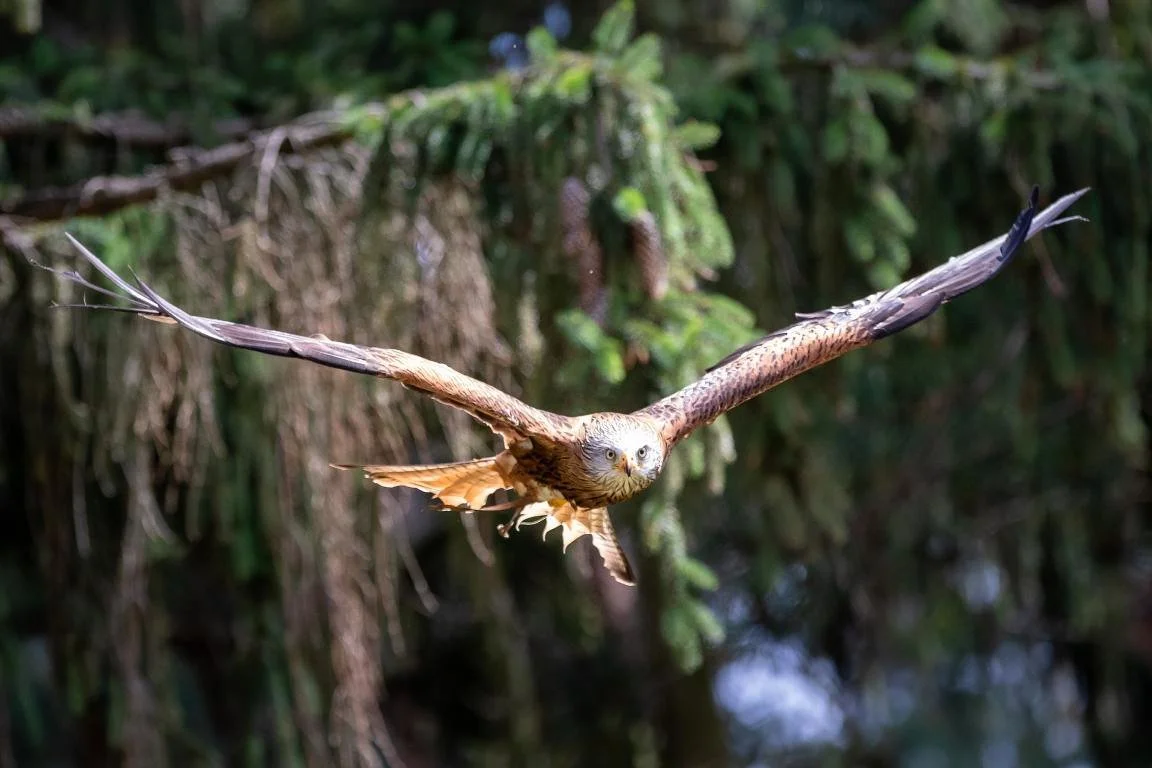
Red Kite in flight
What to See and Do
Watch the daily red kite feeding sessions at the Red Kite Feeding Station & Rehabilitation Centre
Explore Gilfach Nature Reserve with its meadows, rivers, waterfalls, and valley views
Visit The Wilderness Project on the banks of the River Wye for bushcraft, navigation training, and outdoor skills workshops
Try outdoor activities including mountain biking trails, Lion Royal Pony Trekking Centre, Pump Track Wales and Valley View Rhayader
Visit the Carad Rhayader Museum and Gallery to learn about the area’s social, cultural, and natural history
Tour Welsh Royal Crystal, Wales’ only hand-crafted crystal glass maker, and watch master craftsmen at work
Rhayader is an excellent base for exploring the Elan Valley and the wider Cambrian Mountains. The town is especially famous as the home of the red kite and has played a major role in the conservation of this once-rare bird of prey in Wales.
One of the main attractions is the Red Kite Feeding Station & Rehabilitation Centre, where you can watch red kites being fed daily from a purpose-built hide, often just a few feet away as the birds swoop overhead.
Rhayader also works well as a hub for walking, cycling, and outdoor activities, with easy access to rivers, reservoirs, forests, and open moorland.
-
Rhayader has several convenient places to park depending on what you plan to visit.
There are public car parks in and around the town centre, all within easy walking distance of shops, cafés, and local attractions.
If you are visiting the Red Kite Feeding Station, there is dedicated parking at the site.
Gilfach Nature Reserve also has its own parking areas for visitors using the walking trails.
For Elan Valley trips, additional parking is available at the dams and visitor centre once you leave the town.
Tips:
If you are spending time in the town itself, use one of the central car parks and explore on foot.
If you are heading straight into the Elan Valley or to a specific attraction, it is often easier to park at the destination itself.
-
The area around Rhayader has been inhabited for thousands of years. The nearby hills and valleys provided fertile land for farming and attracted early settlers.
Rhayader grew in importance during the medieval period, becoming a market town and trading centre. The town's strategic location along the River Wye contributed to its prosperity and development.
In the 18th and 19th centuries, Rhayader thrived as an agricultural hub and centre for wool production. The town's mills and workshops played a vital role in the local economy, attracting workers from surrounding areas.
Rhayader's location on major trade routes, including the historic drovers' roads and the Elan Valley Railway, further bolstered its importance as a transportation hub. The railway connected Rhayader to nearby towns and cities, facilitating the movement of goods and people.
Beyond its historical significance, Rhayader is renowned for its stunning natural beauty. Nestled amidst the Cambrian Mountains and bordered by the Elan Valley, the town is surrounded by picturesque landscapes, including rolling hills, lush forests, and tranquil lakes.
Today, Rhayader is a popular destination for outdoor enthusiasts, offering a wide range of recreational activities such as hiking, cycling, fishing, and birdwatching. Visitors can explore the nearby Elan Valley Reservoirs, known for their scenic beauty and abundant wildlife.
-
Rhayader is one of the most important places in Wales for the conservation of the red kite.
By the late 20th century, the red kite had become extremely rare in Britain due to persecution and habitat loss. The area around Rhayader became a key centre for conservation efforts, helping to protect and re-establish the species in Wales.
The Red Kite Feeding Station was established to support these efforts and to allow visitors to see the birds at close range without disturbing them in the wild. Today, red kites are once again a common sight across much of Wales, and Rhayader remains one of the best places in the country to see them in large numbers.
Watching dozens of red kites circling and diving for food is one of the most memorable wildlife experiences in mid Wales.
Rhayader by Night: Stepping Off the Edge of the Map
Rhayader is not a stargazing destination in itself — but it is one of the best launch points into darkness anywhere in Wales.
Within minutes of leaving town, streetlights and settlements fall away and the road climbs into the Elan Valley, where the landscape opens into one of the UK’s only International Dark Sky Parks.
By Day: Elan Valley
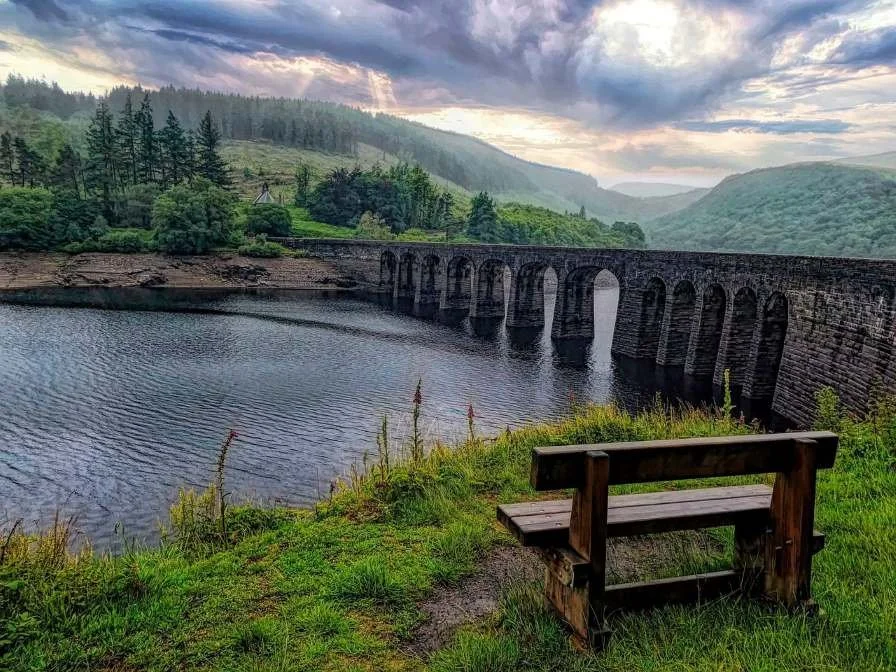
Elan Valley Lakes is one of the most spectacular and unspoilt landscapes in Wales. Set deep in the Cambrian Mountains, it is a vast estate of reservoirs, dams, moorland, and empty mountain roads, created over 100 years ago to supply water to Birmingham via a 73-mile aqueduct.
This is a place of big skies, long views, quiet roads, and dramatic engineering, where Victorian ambition meets wild Welsh scenery. It is ideal for slow exploration by car, bike, or on foot.
The main hub for visitors is the Visitor Centre, where you’ll find information, maps, bike hire, a café, and a gift shop. Nearby is Penbont House Tea Room a popular stop for food and drinks.
What to See and Do
Discover the reservoirs and dams, including:
Caban Coch Dam
Garreg Ddu Dam
Pen y Garreg Dam
Craig Goch Dam
Claerwen Dam
Drive or cycle the spectacular mountain roads linking the reservoirs
Walk around the lakes and into the surrounding hills
Visit the Visitor Centre for maps, exhibitions, and bike hire
Discover the story of the “lost valleys” flooded to create the reservoirs
Stop at Penbont House Tea Room or the visitor centre café
Activities include: Walking and cycling, Scenic driving, Wildlife watching, Stargazing, Fishing and angling and Kayaking (in permitted areas)
-
Getting there:
The Elan Valley is best explored by car or bike.
The main access is via Rhayader, from where a scenic road leads directly into the estate.
Visitor centre:
The Elan Valley Visitor Centre is the best starting point and has:
Parking
Maps and information
Bike hire
Café and toilets
Parking:
There are multiple car parks around the dams and reservoirs, including at:
Claerwen Dam
Craig Goch Dam
Near the main reservoirs and viewpoints
These make it easy to explore the valley in sections rather than all at once.
Good to know:
Roads are narrow and winding in places, but quiet and very scenic
Mobile signal can be limited or absent
Weather can change quickly — even in summer
-
Human activity in the Elan Valley goes back over 4,000 years, but the landscape you see today was shaped most dramatically at the end of the 19th century.
In the 1890s, Birmingham Corporation chose this remote valley as the site for a massive engineering project to supply clean water to the growing industrial city. Entire valleys were flooded, farms and settlements were abandoned, and a chain of huge dams and reservoirs was built.
The project also created:
The 73-mile aqueduct to Birmingham
The iconic stone dams
Model villages and worker housing
A new, carefully managed estate landscape
Today, the Elan Valley remains owned and managed by Welsh Water, and it stands as one of the greatest examples of Victorian civil engineering in Britain, set within a landscape that still feels wild and remote.
-
The Elan Valley sits within one of the oldest and most complex landscapes in Wales.
Here you can learn about:
The Ice Age and how glaciers shaped the valleys
Ancient seas and continental drift
Earthquakes and submarine canyons
The mineral-rich geology that helped shape the wider Cambrian Mountains
This deep geological history is part of what gives the Elan Valley its dramatic, sweeping forms and wide open character.
Elan Valley: One of the Darkest Places in the UK (By Night)
The Elan Valley is designated an International Dark Sky Park and was the first privately owned estate in the world to receive this status (in 2015). Covering around 45,000 acres, the entire area is protected against light pollution and holds Silver-tier status with the International Dark Sky Association. Read more about star gazing at Elan Valley.
This is one of the darkest landscapes in Britain.
On clear nights, the Milky Way is often visible to the naked eye, and in 2016 the Northern Lights were even seen here.
Excellent stargazing locations include:
The area around Cwmdauddwr Common
The car parks at Graig Goch and Claerwen Dam
Here, stargazing is not something squeezed into the margins of the day — it is the main event.
The Claerwen Mountain Road: Driving into Darkness
One of the most memorable ways to experience the Elan Valley is simply to drive through it as evening falls.
The high road that loops past the Claerwen Dam and across the uplands is often described as one of the loneliest and most atmospheric drives in Wales. There are long stretches with no settlements, no streetlights, and no other traffic — just the road, the reservoirs, and the dark hills.
On a clear evening, you don’t even need to stop to feel the scale of the night sky here. The stars appear gradually as the last light fades, and by the time you reach the higher points of the route, the landscape is completely swallowed by darkness.
It’s not a road to rush. Drive slowly, watch for wildlife, and treat the journey itself as part of the stargazing experience. Mobile signal is limited in places, so make sure you’re fuelled up and know your route before setting out.
The Cambrian Mountains
Beyond the Elan Valley lies the vast upland plateau of the Cambrian Mountains — often described as the backbone of Wales.
This is one of the wildest and least populated regions in the country, stretching across parts of Powys, Ceredigion, and Gwynedd. Peaks rise to over 700 metres, including Plynlimon, and this is the source region of some of Wales’ great rivers: the Wye, Severn, and Teifi.
It is a land of:
Empty roads
Sweeping moorland
Big reservoirs
Dramatic weather
And an overwhelming sense of space
Geographically, the Cambrian Mountains are a high plateau with numerous peaks over 600 metres, rising to Plynlimon (752 m), the highest point in the range. This region is the source of some of Wales’ greatest rivers, including the Wye, Severn, and Teifi, which flow outwards into deep valleys and across the country.
This is a land of big skies, empty roads, sweeping moorland, reservoirs, forests, and dramatic weather — one of the true wilderness areas of Wales.
Heritage in the Wilderness (By Day)
Despite its emptiness, this is a landscape deeply marked by human history.
The Cambrian Mountains are often described as the backbone of Wales, and their landscape is steeped in history.
Explore the historic lead mines of Cwmystwyth, among the oldest in Europe, revealing the region’s long industrial past.
Visit Soar y Mynydd, a remote Calvinist Methodist chapel deep in the mountains, still holding services today.
Discover Strata Florida Abbe near Pontrhydfendigaid, one of the most important medieval monastic sites in Wales, once home to Cistercian monks who shaped much of the surrounding landscape.
Walking & Exploring
The region is ideal for walking, quiet exploring, and slow travel.
There are 11 scenic local footpaths crossing moorland, valleys, forests, and river landscapes.
Many walks link into villages and small towns with cafés, pubs, and tearooms along the way.
This is walking for people who like space, silence, and big horizons rather than crowds.
The Cambrian Mountains by Night: The Darkest Heart of Wales

Mynydd Llanllwni Mountain, Llanllwni, Carmarthenshire
The Cambrian Mountains are not just another range on the map — they are one of the last true wilderness areas in Britain.
Vast, high, and thinly populated, this upland plateau stretches across the centre of Wales in a great sweep of moorland, reservoirs, forests, and empty roads. By day it feels remote. By night, it feels almost limitless.
This is one of the darkest regions in the entire country. There are no cities here, few towns, and long distances between any real sources of artificial light. On a clear night, the sky is not just something above you — it becomes the dominant feature of the landscape.
To protect and celebrate this, nineDark Sky Discovery Sites have been designated across the region, linked together as the Cambrian Mountains Astro Trail. Rather than a single destination, this is a journey through darkness: a chain of places spread across roughly 50 miles (80 km), designed for slow, multi-night exploration.
Driving here after sunset is part of the experience. Roads wind through empty valleys and over high passes, with long stretches of complete blackness between settlements. When you stop and step out of the car, the scale of the sky becomes immediately obvious: the Milky Way often arches overhead, constellations like Orion and the Great Plough are sharply defined, and on the best nights the sky feels almost three-dimensional.
What makes the Cambrians special is not just the quality of the stars, but the setting in which you see them. Many of these sites sit beside remote chapels, abbey ruins, old mines, reservoirs, and lonely hostels — places that already feel far from the modern world by day, and utterly removed from it by night.
This is not casual stargazing. This is travelling into one of the quietest and darkest landscapes left in Wales — and staying long enough to let it sink in.
-
These combine naturally with a day in the Elan Valley.
Pont ar Elan Car Park (Cwm Elan) – Inside the Dark Sky Park itself
Y Star Inn Car Park, Dylife – A perfectly named pub stop for stargazingon text goes here
-
These sit deep in the mountains, among abbeys, mines, and empty valleys.
Y Bwa (The Arch), Cwmystwyth – Near Devil’s Bridge and the historic mines
Coed y Bont, Pontrhydfendigaid – Near Strata Florida Abbey
Hostel Dolgoch, Tregaron – Close to the source of the River Tywi
Hostel Ty’n y Cornel, Llanddewi Brefi – Near Soar y Mynydd chapel
-
These work well if approaching from or heading towards South-West Wales.
Llyn Brianne Reservoir Car Park – One of the loneliest and darkest-feeling locations
Mynydd Llanllwni Mountain – A superb viewpoint by day and night
Llanerchaeron (National Trust) – On the River Aeron near the Georgian villa
Together, these form a multi-night stargazing route through one of the emptiest landscapes in the country.

Leaving the Cambrians
From here, the route begins to climb again, becoming steeper, more rugged, and more dramatic.
The next chapter takes you into North Wales — where Wales rises sharply into its most famous mountains, and the journey reaches its most vertical and spectacular stage.
Wales Stargazing: Dark Skies Last updated: 21 January 2026
Some links may earn Uncover Britain a small commission at no extra cost to you. This helps support the ongoing creation, review and presentation of our road trip guides.
Route information and listings are provided for general guidance only. Always use your preferred navigation system and check official websites to confirm suitability, opening times and the latest details before travelling.
Our guides are reviewed regularly and supported by a mix of editorial research and digital tools to help keep content clear and up to date. If you spot anything that needs updating, we’re always glad to hear from you.